close
-
Layers w
- Weather Layers
- Pro
- Pro
- Pro
- Pro
- Pro
- Pro
- More Layers
- Pro
- Pro
- Pro
- Pro
-
Upgrade to

3D
Trail Conditions
- Unknown
- Snow Groomed
- Snow Packed
- Snow Covered
- Snow Cover Partial
- Freeze/thaw Cycle
- Icy
- Prevalent Mud
- Wet
- Variable
- Ideal
- Dry
- Very Dry
Trail Flow (Ridden Direction)
Trailforks scans users ridelogs to determine the most popular direction each trail is ridden. A good flowing trail network will have most trails flowing in a single direction according to their intension.
The colour categories are based on what percentage of riders are riding a trail in its intended direction.
The colour categories are based on what percentage of riders are riding a trail in its intended direction.
- > 96%
- > 90%
- > 80%
- > 70%
- > 50%
- < 50%
- bi-directional trail
- no data
Trail Last Ridden
Trailforks scans ridelogs to determine the last time a trail was ridden.
- < 2 days
- < 1 week
- < 2 weeks
- < 1 month
- < 6 months
- > 6 months
Trail Ridden Direction
The intended direction a trail should be ridden.
- Downhill Only
- Downhill Primary
- Both Directions
- Uphill Primary
- Uphill Only
- One Direction
Contribute Details
Colors indicate trail is missing specified detail.
- Description
- Photos
- Description & Photos
- Videos
Trail Popularity ?
Trailforks scans ridelogs to determine which trails are ridden the most in the last 9 months.
Trails are compared with nearby trails in the same city region with a possible 25 colour shades.
Think of this as a heatmap, more rides = more kinetic energy = warmer colors.
- most popular
- popular
- less popular
- not popular
ATV/ORV/OHV Filter
Max Vehicle Width
inches
US Cell Coverage
Legend

Radar Time
Activity Recordings
Trailforks uses anonymized public activity data.
?
Activity Recordings
Trailforks uses anonymized public activity data.
?
Personal Heatmap
▶
Activity Types
all
/
none
▶
Options
2
Date range
month
–
Winter Trails
Warning
A routing network for winter maps does not exist. Selecting trails using the winter trails layer has been disabled.
Missing Trails
Most Popular
Least Popular
Trails are colored based on popularity. The more popular a trail is, the more red. Less popular trails trend towards green.
Jump Magnitude Heatmap
Heatmap of where riders jump on trails. Zoom in to see individual jumps, click circles to view jump details.
BC Backroad Status
![map legend]()
Service Road Atlas is a free to use, community-driven service for viewing and creating reports on the numerous back-country service roads around B.C. and Alberta.

Slope Aspect
Direction the slope faces
Trails Deemphasized
Trails are shown in grey.
Only show trails with no bike usage.
Suggested Layers
Based on selected activity type
Save the current map location and zoom level as your default home location whenever this page is loaded.
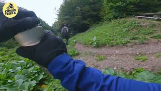
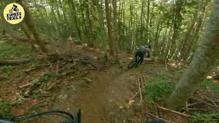
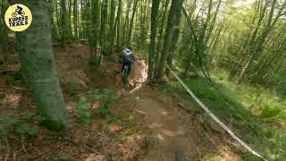
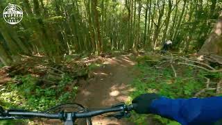
SaveWelcome to Kupres riding area The tracks here focus on Enduro-Mountainbiking. If you are looking for raw natural tracks come here, ride and have a good time!
Miro from Kupres MTB Trails is maintaining the local tracks. You can shuttle with him, stay at his place. It's possible to rent the small appartement or stay with your Camper / Van at the parking lot. For more information visit Miro's Homepage https://kupresmtbtrails.com/.
Miro from Kupres MTB Trails is maintaining the local tracks. You can shuttle with him, stay at his place. It's possible to rent the small appartement or stay with your Camper / Van at the parking lot. For more information visit Miro's Homepage https://kupresmtbtrails.com/.
Links
Activities Click to view
- Mountain Bike
11 trails
- E-Bike
6 trails
- Adaptive Bike
- Hike
5 trails
- Trail Running
5 trails
Region Details
- 1
- 1
- 8
- 1
Region Status
Open as of Apr 29, 2026Stats
- Avg Trail Rating
- Trails (view details)
- 11
- Trails Mountain Bike
- 11
- Trails E-Bike
- 6
- Trails Hike
- 5
- Trails Trail Running
- 5
- Total Distance
- 7 miles
- Total Descent Distance
- 5 miles
- Total Descent
- 5,740 ft
- Total Vertical
- 1,380 ft
- Highest Trailhead
- 5,393 ft
- Reports
- 20
- Photos
- 30
- Ridden Counter
- 219
Popular Kupres Mountain Biking Trails
• 50 ★ 4.5 • 2,792 ft • 0 ft • 30 •
• 45 ★ 4.5 • 1 mile • 0 ft • 28 •
Stage from Kupres Enduro Race. Build by Miro - the local trail and shuttle guy
• 75 ★ 0.0 • 617 ft • 0 ft • 27 •
Popular blue difficulty singletrack. This mountain bike primary trail can be used downhill only. Trail visibility is always easy to follow. On average it takes minutes to complete this trail.
• 60 ★ 5.0 • 1 mile • 0 ft • 20 •
Very natural but build trail. Funny and flowy. Some techy sections & loose turns. All in the woods on good dirt. Some gravel and stones. Build by Miro - he is the local mtb trail builder and bike guide. Contact him for shuttles...
• 25 ★ 4.5 • 5,039 ft • 0 ft • 19 •
Monster is a build trail but still very flowy and natural. Some techy narrow sections
• 95 ★ 0.0 • 2,861 ft • 0 ft • 16 •
Popular blue difficulty singletrack. This mountain bike primary trail can be used downhill only. On average it takes 4 minutes to complete this trail.
• 85 ★ 0.0 • 2,418 ft • 0 ft • 10 •
Popular blue difficulty singletrack. This mountain bike primary trail can be used both directions.

Recent Trail Reports
| status | trail | date | condition | info | user |
|---|---|---|---|---|---|
| Ivan | Apr 29, 2026 @ 10:28pm (Europe/Sarajevo) Apr 29, 2026 | Ideal | DanielWy2dJ4 | ||
| Barakusa | Apr 29, 2026 @ 10:26pm (Europe/Sarajevo) Apr 29, 2026 | Variable | DanielWy2dJ4 | ||
| Kasama | Sep 20, 2025 @ 10:23am (Europe/Sarajevo) Sep 20, 2025 | Dry | somebody959 | ||
| HillBilly | Sep 20, 2025 @ 10:23am (Europe/Sarajevo) Sep 20, 2025 | Ideal | somebody959 | ||
| Katerina | Sep 20, 2025 @ 10:23am (Europe/Sarajevo) Sep 20, 2025 | Ideal | somebody959 | ||
| Katerina Gornja | Sep 20, 2025 @ 10:23am (Europe/Sarajevo) Sep 20, 2025 | Ideal | somebody959 | ||
| Kupres Full Flow | Sep 20, 2025 @ 10:23am (Europe/Sarajevo) Sep 20, 2025 | Ideal | somebody959 | ||
| HillBilly | Jul 14, 2023 @ 3:11am Jul 14, 2023 | Ideal | gezzzz | ||
| Monster | Aug 21, 2022 @ 6:56am Aug 21, 2022 | Ideal | Joma198 |
Activity Feed
| username | action | type | title | date |
|---|---|---|---|---|
| DanielWy2dJ4 | add | report | activity #93668979 and 1 more | Apr 29, 2026 @ 1:26pm Apr 29, 2026 |
| DanielWy2dJ4 | ridden | trail | activity #93668755 and 1 more | Apr 29, 2026 @ 1:22pm Apr 29, 2026 |
| DanielWy2dJ4 | vote | trail | activity #93668723 and 1 more | Apr 29, 2026 @ 1:21pm Apr 29, 2026 |
| somebody959 | add | report | activity #80882607 and 6 more | Sep 22, 2025 @ 2:04am Sep 22, 2025 |
| 8Xn88t | ridden | trail | activity #80877924 and 3 more | Sep 21, 2025 @ 10:13pm Sep 21, 2025 |
Local Badges
-

Epic Mountain Bike Climb 2k2 awarded -

Climbing 10k Badge0 awarded -

Mountain Biking 100k Badge0 awarded -

Epic Ride Descent 2k2 awarded -

Descent 10k Badge0 awarded -

Descent 100k Badge0 awarded
Activity Type Stats
| activitytype | trails | distance | descent | descent distance | total vertical | rating | global rank | state rank | photos | reports | routes | ridelogs |
|---|---|---|---|---|---|---|---|---|---|---|---|---|
| Mountain Bike | 11 | 7 miles | 5,741 ft | 5 miles | 1,381 ft | #2,130 | #4 | 30 | 20 | 197 | ||
| E-Bike | 6 | 6 miles | 4,954 ft | 5 miles | 1,381 ft | #1,726 | #7 | 20 | 11 | |||
| Hike | 5 | 5 miles | 3,789 ft | 4 miles | 1,381 ft | #2,817 | #10 | 18 | 10 | |||
| Trail Running | 5 | 5 miles | 3,789 ft | 4 miles | 1,381 ft | #2,320 | #9 | 18 | 1 |
Frequently Asked Questions About Kupres
▼
What are the highest rated mountain biking trails in Kupres?
▼
What is the best time of the year to ride in Kupres?
Based on ride log data, the most popular months to ride in Kupres are:
- July (2 activities)
▼
Where can I park to ride in Kupres?
Check the Kupres trail map for trailhead and parking information. Community members regularly update access and parking details for trails in the area.
▼
What is the longest trail in Kupres?
The longest trail in Kupres is Kupres Full Flow at 2.6 km. View all trails sorted by distance.
Activities
Trails
Points of Interest
- By marko-ristivojevic-evolution
 MTB Evolution PD Trebevic & contributors
 - Admins: apply
- #47602 - 3,432 views
- kupres activity log | embed map of Kupres mountain bike trails | kupres mountain biking points of interest
Downloading of trail gps tracks in kml & gpx formats is enabled for Kupres.
You must login to download files.