close
-
Layers w
- Weather Layers
- Pro
- Pro
- Pro
- Pro
- Pro
- Pro
- More Layers
- Pro
- Pro
- Pro
- Pro
-
Upgrade to

3D
Trail Conditions
- Unknown
- Snow Groomed
- Snow Packed
- Snow Covered
- Snow Cover Partial
- Freeze/thaw Cycle
- Icy
- Prevalent Mud
- Wet
- Variable
- Ideal
- Dry
- Very Dry
Trail Flow (Ridden Direction)
Trailforks scans users ridelogs to determine the most popular direction each trail is ridden. A good flowing trail network will have most trails flowing in a single direction according to their intension.
The colour categories are based on what percentage of riders are riding a trail in its intended direction.
The colour categories are based on what percentage of riders are riding a trail in its intended direction.
- > 96%
- > 90%
- > 80%
- > 70%
- > 50%
- < 50%
- bi-directional trail
- no data
Trail Last Ridden
Trailforks scans ridelogs to determine the last time a trail was ridden.
- < 2 days
- < 1 week
- < 2 weeks
- < 1 month
- < 6 months
- > 6 months
Trail Ridden Direction
The intended direction a trail should be ridden.
- Downhill Only
- Downhill Primary
- Both Directions
- Uphill Primary
- Uphill Only
- One Direction
Contribute Details
Colors indicate trail is missing specified detail.
- Description
- Photos
- Description & Photos
- Videos
Trail Popularity ?
Trailforks scans ridelogs to determine which trails are ridden the most in the last 9 months.
Trails are compared with nearby trails in the same city region with a possible 25 colour shades.
Think of this as a heatmap, more rides = more kinetic energy = warmer colors.
- most popular
- popular
- less popular
- not popular
ATV/ORV/OHV Filter
Max Vehicle Width
inches
US Cell Coverage
Legend

Radar Time
Activity Recordings
Trailforks uses anonymized public activity data.
?
Activity Recordings
Trailforks uses anonymized public activity data.
?
Personal Heatmap
▶
Activity Types
all
/
none
▶
Options
2
Date range
month
–
Winter Trails
Warning
A routing network for winter maps does not exist. Selecting trails using the winter trails layer has been disabled.
Missing Trails
Most Popular
Least Popular
Trails are colored based on popularity. The more popular a trail is, the more red. Less popular trails trend towards green.
Jump Magnitude Heatmap
Heatmap of where riders jump on trails. Zoom in to see individual jumps, click circles to view jump details.
BC Backroad Status
![map legend]()
Service Road Atlas is a free to use, community-driven service for viewing and creating reports on the numerous back-country service roads around B.C. and Alberta.

Slope Aspect
Direction the slope faces
Trails Deemphasized
Trails are shown in grey.
Only show trails with no bike usage.
Suggested Layers
Based on selected activity type
Save the current map location and zoom level as your default home location whenever this page is loaded.
Save
No description for La Quinta has been added yet!
Login or register to submit one.
Activities Click to view
- Mountain Bike
53 trails
- E-Bike
14 trails
- Winter Fat Bike
0 trails
- Hike
55 trails
- Trail Running
54 trails
Region Details
- 2
- 15
- 20
- 13
Region Status
Open as of May 21, 2026Stats
- Avg Trail Rating
- Trails (view details)
- 50
- Trails Mountain Bike
- 54
- Trails E-Bike
- 14
- Trails Horse
- 2
- Trails Hike
- 55
- Trails Trail Running
- 54
- Trails ATV/ORV/OHV
- 1
- Total Distance
- 41 miles
- Total Descent
- 6,855 ft
- Total Vertical
- 4,311 ft
- Highest Trailhead
- 4,345 ft
- Reports
- 187
- Photos
- 485
- Ridden Counter
- 8,130
Sub Regions
-
La Quinta Cove
- 15
- 18
- 12
Popular La Quinta Mountain Biking Trails
• 30 ★ 4.6 • 13 miles • 445 ft • 871 •
Palm Canyon is an epic high California desert ride that provides great desert views, narrow single track, significant exposure that should only be attempted by experienced riders. Trail starts off with an excellent downhill into Palm...
• 50 ★ 4.5 • 2,293 ft • 0 ft • 186 •
Moderately popular black diamond difficulty singletrack. This mountain bike primary trail can be used both directions. On average it takes 2 minutes to complete this trail.
• 80 ★ 1.0 • 1,270 ft • 4 ft • 176 •
Avoids the harder "round the mountain" loop option for Lake Trail. Basic dirt road.
• 45 ★ 4.0 • 4,904 ft • 11 ft • 173 •
singletrack through rock garden. some spots are fairly technical. the rest is rather intermediate
• 95 ★ 0.0 • 577 ft • 0 ft • 170 •
Quick jaunt to link into Cove Rock Garden from Slalom
La Quinta Mountain Bike Routes
★ 4.8 • 27 miles • 2,285 ft • 4 • Shuttled •
Shuttle Ride starting on to Art Smith to downhills Goat Trail to Palm Desert
★ 1.0 • 9 miles • 1,279 ft • 16 •
This route tries to fit in the most popular trails in La Quinta Cove, and does 2 laps around the main loop...
14 miles • 1,740 ft • 3 • Loop •
This is a sizable sampling of the trails. You will get to check out some of the goods around the...
12 miles • 1,488 ft • 2 • Loop •
This route takes from Pinyon Flats Campground out on the Pinyon Flats Trail and then cutting over to the...
11 miles • 2,104 ft • 1 • Loop •
Route linking Cove to Lake and Boo Hoff Trails, with short road route available to link finish and start.
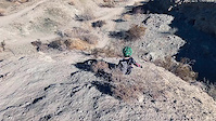
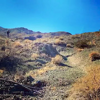
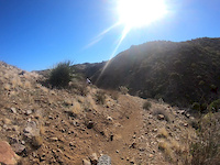
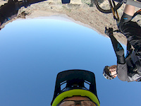
Photos of La Quinta Mountain Bike
Videos of La Quinta Mountain Bike
trail: Big Horn 3
0:23 |
88 |
Jan 14, 2021
trail: Rough N Stuff
0:13 |
95 |
Dec 22, 2020

trail: The Spine
0:11 |
56 |
Dec 22, 2020

trail: The Spine
0:17 |
53 |
Dec 22, 2020

trail: Boo Hoff Trail
5:41 |
35 |
Dec 3, 2020
trail: Palm Canyon Trail
5:18 |
175 |
Feb 8, 2020

trail: Rock N Roll
2:25 |
295 |
Jan 25, 2019
trail: Palm Canyon Trail
0:42 |
|
Jan 22, 2019
Recent Trail Reports
| status | trail | date | condition | info | user |
|---|---|---|---|---|---|
| Palm Canyon Trail | May 21, 2026 @ 1:50am (America/Los_Angeles) May 21, 2026 | Ideal | ev-dog SDMBA | ||
| Ribbonwood Trail | May 21, 2026 @ 1:05am (America/Los_Angeles) May 21, 2026 | Ideal | ev-dog SDMBA | ||
| Pinyon Flats | May 18, 2026 @ 10:36pm (America/Los_Angeles) May 18, 2026 | Ideal | ev-dog SDMBA | ||
| Pinyon to Palm Connector | May 18, 2026 @ 10:30pm (America/Los_Angeles) May 18, 2026 | Unknown | ev-dog SDMBA | ||
| Pinyon to Palm Access | May 18, 2026 @ 10:26pm (America/Los_Angeles) May 18, 2026 | Ideal | ev-dog SDMBA | ||
| Oregon trail extension | Nov 13, 2025 @ 7:11am (America/Tijuana) Nov 13, 2025 | Very Dry | stu1WrcPL | ||
| Access Oregon | Nov 13, 2025 @ 7:11am (America/Tijuana) Nov 13, 2025 | Very Dry | stu1WrcPL | ||
| Boo Hoff Connector | Nov 13, 2025 @ 7:11am (America/Tijuana) Nov 13, 2025 | Very Dry | stu1WrcPL | ||
| Cove to Lake Trail | Apr 28, 2025 @ 11:56am Apr 28, 2025 | Very Dry | renaissancerider | ||
| Desert Rat | Mar 13, 2025 @ 1:22pm Mar 13, 2025 | Ideal | steppi604 |
Activity Feed
| username | action | type | title | date |
|---|---|---|---|---|
| DavidhkT80L | wishlist | route | activity #96937316 | Jun 13, 2026 @ 8:54pm Jun 13, 2026 |
| DavidhkT80L | wishlist | route | activity #96519907 | Jun 7, 2026 @ 9:25pm Jun 7, 2026 |
| juergwidmerch | ridden | route | activity #96021339 | Jun 1, 2026 @ 9:03am Jun 1, 2026 |
| mattdec | wishlist | trail | activity #95872350 | May 30, 2026 @ 11:27am May 30, 2026 |
| ev-dog | comment | trail | activity #95829749 | May 30, 2026 @ 1:41am May 30, 2026 |
Recent Comments
| username | type | title | comment | date |
|---|---|---|---|---|
| trail | If you're staying at the campground this is a... | May 30, 2026 @ 1:41am May 30, 2026 | ||
| report | I’ll bet once they find a way to charge. It... | Feb 15, 2026 @ 7:48pm Feb 15, 2026 | ||
| trail | Fun descent from boo Hoff with some flow, tech... | Jan 23, 2026 @ 12:00pm Jan 23, 2026 | ||
| trail | Perfect way to end a boo Hoff descent. Some... | Jan 23, 2026 @ 11:58am Jan 23, 2026 | ||
| trail | Actually one of my fav trails at cove oasis,... | Jan 23, 2026 @ 11:55am Jan 23, 2026 |
Local Badges
-

Completionist0 awarded -

Epic Mountain Bike Climb 2k3 awarded -

Climbing 10k Badge17 awarded -

Mountain Biking 100k Badge1 awarded -

Epic Ride Descent 2k3 awarded -

Descent 10k Badge18 awarded
Activity Type Stats
| activitytype | trails | distance | descent | descent distance | total vertical | rating | global rank | state rank | photos | reports | routes | ridelogs |
|---|---|---|---|---|---|---|---|---|---|---|---|---|
| Mountain Bike | 53 | 41 miles | 6,854 ft | 21 miles | 4,311 ft | #2,836 | #1,005 | 472 | 186 | 6 | 7,414 | |
| E-Bike | 14 | 3,898 ft | 295 ft | 3,114 ft | 289 ft | #1,022 | #796 | 3 | 137 | 1,114 | ||
| Horse | 2 | 6 | ||||||||||
| Hike | 55 | 41 miles | 6,854 ft | 21 miles | 4,311 ft | #1,461 | #662 | 2 | 186 | 734 | ||
| Trail Running | 54 | 41 miles | 6,854 ft | 21 miles | 4,311 ft | #4,262 | #1,301 | 6 | 186 | 168 | ||
| ATV/ORV/OHV | 1 | 3,478 ft | 79 ft | 7 | 3 |
Frequently Asked Questions About La Quinta
▼
What are the best places to ride in La Quinta?
La Quinta has 1 areas to explore for mountain biking. The top rated areas are:
▼
What are the highest rated mountain biking trails in La Quinta?
The highest rated mountain biking trails in La Quinta are:
- Palm Canyon Trail (4.5/5)
- Pueblo (4.1/5)
- Oregon Trail (4.1/5)
- Upper Oregon (4.1/5)
- Madderhorn East (4.1/5)
▼
What is the best time of the year to ride in La Quinta?
Based on ride log data, the most popular months to ride in La Quinta are:
- December (65 activities)
- January (52 activities)
- March (49 activities)
▼
Where can I park to ride in La Quinta?
There are 3 parking locations listed in La Quinta. The most popular parking spots are: View all parking and trailhead locations on the map to plan your visit.
Activities
Trails
Points of Interest
- By stoker1223 & contributors
- Admins: IVMTB
- #17371 - 9,369 views
- la quinta activity log | embed map of La Quinta mountain bike trails | la quinta mountain biking points of interest
Downloading of trail gps tracks in kml & gpx formats is enabled for La Quinta.
You must login to download files.