close
-
Layers w
- Weather Layers
- Pro
- Pro
- Pro
- Pro
- Pro
- Pro
- More Layers
- Pro
- Pro
- Pro
- Pro
-
Upgrade to

3D
Trail Conditions
- Unknown
- Snow Groomed
- Snow Packed
- Snow Covered
- Snow Cover Partial
- Freeze/thaw Cycle
- Icy
- Prevalent Mud
- Wet
- Variable
- Ideal
- Dry
- Very Dry
Trail Flow (Ridden Direction)
Trailforks scans users ridelogs to determine the most popular direction each trail is ridden. A good flowing trail network will have most trails flowing in a single direction according to their intension.
The colour categories are based on what percentage of riders are riding a trail in its intended direction.
The colour categories are based on what percentage of riders are riding a trail in its intended direction.
- > 96%
- > 90%
- > 80%
- > 70%
- > 50%
- < 50%
- bi-directional trail
- no data
Trail Last Ridden
Trailforks scans ridelogs to determine the last time a trail was ridden.
- < 2 days
- < 1 week
- < 2 weeks
- < 1 month
- < 6 months
- > 6 months
Trail Ridden Direction
The intended direction a trail should be ridden.
- Downhill Only
- Downhill Primary
- Both Directions
- Uphill Primary
- Uphill Only
- One Direction
Contribute Details
Colors indicate trail is missing specified detail.
- Description
- Photos
- Description & Photos
- Videos
Trail Popularity ?
Trailforks scans ridelogs to determine which trails are ridden the most in the last 9 months.
Trails are compared with nearby trails in the same city region with a possible 25 colour shades.
Think of this as a heatmap, more rides = more kinetic energy = warmer colors.
- most popular
- popular
- less popular
- not popular
ATV/ORV/OHV Filter
Max Vehicle Width
inches
US Cell Coverage
Legend

Radar Time
Activity Recordings
Trailforks uses anonymized public activity data.
?
Activity Recordings
Trailforks uses anonymized public activity data.
?
Personal Heatmap
▶
Activity Types
all
/
none
▶
Options
2
Date range
month
–
Winter Trails
Warning
A routing network for winter maps does not exist. Selecting trails using the winter trails layer has been disabled.
Missing Trails
Most Popular
Least Popular
Trails are colored based on popularity. The more popular a trail is, the more red. Less popular trails trend towards green.
Jump Magnitude Heatmap
Heatmap of where riders jump on trails. Zoom in to see individual jumps, click circles to view jump details.
BC Backroad Status
![map legend]()
Service Road Atlas is a free to use, community-driven service for viewing and creating reports on the numerous back-country service roads around B.C. and Alberta.

Slope Aspect
Direction the slope faces
Trails Deemphasized
Trails are shown in grey.
Only show trails with no bike usage.
Suggested Layers
Based on selected activity type
Save the current map location and zoom level as your default home location whenever this page is loaded.
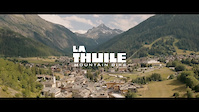
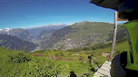
SaveLa Thuile offers a wide variety of trails and routes also outside the bike park. The two areas of Colle San Carlo and Miniere are really nice to ride, with less technical difficulties and in a completely different environment compared to the one that hosts the bike park trails.
Big old military roads such as the one to Col Chavannes or the one to Colle del Fourclaz are the perfect routes for a great e-mtb ride surrounded by glaciers and peaks.
Petosan and La Promise are ideal for families that are looking for a flat, easy and fun ride in the nature.
The town offers all services and accommodation solutions together with the traditional Italian hospitality.
Primary Trail Type: All-Mountain & Downhill
eBikes Allowed:
Yes
Disclaimer:
ITA: I sentieri nel comprensorio di La Thuile che non fanno parte del bike park e non sono quindi serviti dagli impianti di risalita, sono da considerarsi ad uso promiscuo. Non sono mantenuti come i trail del bike park e pertanto bisogna percorrerli con estrema cautela e sotto la propria responsabilità.
EN: The trails around the town of La Thuile, which are not part of the bike park and served by the lifts, are multi use trails. They are not maintained like the bike park trails and therefore they must be used with the utmost caution and under your own responsibility.
EN: The trails around the town of La Thuile, which are not part of the bike park and served by the lifts, are multi use trails. They are not maintained like the bike park trails and therefore they must be used with the utmost caution and under your own responsibility.
This region uses the Uk/Euro style trail grading system.
Activities Click to view
- Mountain Bike
40 trails
- E-Bike
39 trails
- Gravel Bike
0 trails
- Adaptive Bike
0 trails
- Winter Fat Bike
0 trails
- Horse
0 trails
- Hike
30 trails
- Trail Running
29 trails
- Snowshoe
8 trails
- Downhill Ski
60 trails
Region Details
- 14
- 2
- 7
- 7
- 9
Region Status
Open as of Apr 24, 2026Stats
- Avg Trail Rating
- Trails (view details)
- 111
- Trails Mountain Bike
- 40
- Trails E-Bike
- 39
- Trails Hike
- 30
- Trails Trail Running
- 29
- Trails Snowshoe
- 8
- Trails Downhill Ski
- 60
- Trails Backcountry Ski
- 1
- Total Distance
- 121 miles
- Total Descent Distance
- 82 miles
- Total Descent
- 67,779 ft
- Total Vertical
- 6,536 ft
- Highest Trailhead
- 10,908 ft
- Reports
- 856
- Photos
- 208
- Ridden Counter
- 19,576
Articles
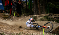
Video: So Fast, So Close, So Cruel - Norco Race Division's 'Just Getting Started' EP6
Jul 22, 2025 from pinkbike.com
A look at the high-altitude, high-stress reality of racing two weekends in a row.
Video: This Gap Won The Race | Downhill Story Of The Race with Ben Cathro
Jul 7, 2025 from pinkbike.com
Ben Cathro recaps the Downhill World Cup racing in La Thuile.
Video: WynTV La Thuile World Cup Trackwalk 2025
Jul 3, 2025 from pinkbike.com
First looks and impressions of the brand-new, exceptionally steep track.
Video: A Look Behind The Scenes Building the La Thuile MTB World Cup Track
Jun 27, 2025 from pinkbike.com
Things look to be shaping up nicely for the newest track on the circuit.
Sub Regions
-
La Thuile Bike World
- 3
- 6
- 8
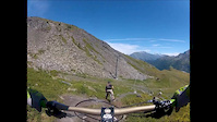
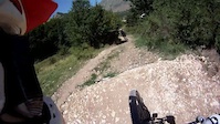
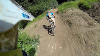
Popular La Thuile Mountain Biking Trails
• 90 ★ 4.6 • 4,652 ft • 0 ft • 590 •
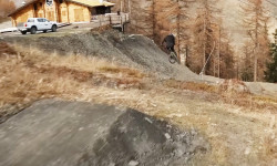
IT: sentiero del Bike Park La Thuile. Il sentiero è molto ripido e in alcuni tratti roccioso. Il terreno è molto secco e scivoloso. EN: trail part of the Bike Park La Thuile. Th is very steep and sometimes rocky. The terrain is very...
• 85 ★ 4.6 • 3,333 ft • 23 ft • 577 •
IT: sentiero del Bike Park La Thuile. Ci sono molte rocce e grandi radici. Ci sono delle piccole salite nel sentiero EN: trail part of the Bike Park La Thuile. There are many rocks and roots and some small climbs
• 80 ★ 4.3 • 2 miles • 0 ft • 530 •
Highly rated popular red difficulty alpine singletrack. This mountain bike primary trail and has a hard overall physical rating with a 0 ft green climb. It features bridge and drop. Trail visibility is always easy to follow. On average it takes 12 minutes to complete this trail.
• 75 ★ 4.9 • 4,869 ft • 0 ft • 485 •
Highly rated popular black difficulty alpine singletrack. This mountain bike primary trail can be used downhill only and has a hard overall physical rating with a 0 ft blue climb. Trail visibility is always easy to follow. On average it takes 9 minutes to complete this trail.
La Thuile Mountain Bike Routes
2 miles • 388 ft • 1 • Loop •
The shakedown session is designed to be a practice run where riders can familiarize themselves with the...
10 miles • 2,148 ft • 0 • Point to Point •
The mountains that unite France and Italy offer an itinerary to bike, immersed in a landscape where...
10 miles • 2,148 ft • 0 • Point to Point •
After have left the car at the La Thuile cable car park, use the Bosco express and Chalet express...
12 miles • 2,525 ft • 0 • Point to Point •
Left the car in the village centre, take the uphill road towards Les Chavonnes Hautes and the golf area,...
★ 1.0 • 30 miles • 10,000 ft • 6 • Loop • Race •
The La Thuile Enduro World Cup course features four intense stages across a single race day. Riders will...
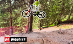
Photos of La Thuile Mountain Bike
Videos of La Thuile Mountain Bike
trail: Warm Up
3:10 |
101 |
Aug 16, 2016
trail: Warm Up
2:01 |
58 |
Aug 3, 2016
trail: Fresa
3:57 |
30378 |
Oct 25, 2015
trail: Touriasse
15:26 |
280 |
May 31, 2015
trail: Flow
4:08 |
391 |
Aug 30, 2014
trail: Promise
10:03 |
422 |
Aug 11, 2014

trail: Flow
4:38 |
294 |
Jul 26, 2014
trail: Flow
7:05 |
1909 |
Jul 22, 2014
Recent Trail Reports
| status | trail | date | condition | info | user |
|---|---|---|---|---|---|
| Vertical - Upper | Apr 24, 2026 @ 3:16pm (Europe/Rome) Apr 24, 2026 | Snow Covered | albertoritm | ||
| Vertical - Lower | Apr 24, 2026 @ 3:16pm (Europe/Rome) Apr 24, 2026 | Snow Covered | albertoritm | ||
| Touriasse | Apr 24, 2026 @ 3:16pm (Europe/Rome) Apr 24, 2026 | Snow Covered | albertoritm | ||
| Touriasse Connector | Apr 24, 2026 @ 3:16pm (Europe/Rome) Apr 24, 2026 | Snow Covered | albertoritm | ||
| Tombeau | Apr 24, 2026 @ 3:16pm (Europe/Rome) Apr 24, 2026 | Snow Covered | albertoritm | ||
| Village Flow | Apr 24, 2026 @ 3:16pm (Europe/Rome) Apr 24, 2026 | Snow Covered | albertoritm | ||
| Ponteilles | Apr 24, 2026 @ 3:16pm (Europe/Rome) Apr 24, 2026 | Snow Covered | albertoritm | ||
| Piloni | Apr 24, 2026 @ 3:16pm (Europe/Rome) Apr 24, 2026 | Snow Covered | albertoritm | ||
| Mulino | Apr 24, 2026 @ 3:16pm (Europe/Rome) Apr 24, 2026 | Snow Covered | albertoritm | ||
| Longet | Apr 24, 2026 @ 3:16pm (Europe/Rome) Apr 24, 2026 | Snow Covered | albertoritm |
Activity Feed
| username | action | type | title | date |
|---|---|---|---|---|
| mirkodh73 | rsvp | event | activity #96917832 | Jun 13, 2026 @ 2:41pm Jun 13, 2026 |
| MatteoAr | ridden | trail | activity #96068398 | Jun 2, 2026 @ 1:28am Jun 2, 2026 |
| AlessandroJZ04Uv | ridden | trail | activity #96014238 | Jun 1, 2026 @ 6:51am Jun 1, 2026 |
| Inve73 | ridden | trail | activity #95824872 | May 29, 2026 @ 11:01pm May 29, 2026 |
| minimusprime | wishlist | trail | activity #95801261 | May 29, 2026 @ 2:08pm May 29, 2026 |
Recent Comments
| username | type | title | comment | date |
|---|---|---|---|---|
| trail | Tight switchbacks in the first part. Needs... | Aug 22, 2025 @ 4:22am Aug 22, 2025 | ||
| trail | Top bit good; bottom barely exists as WC trip... | Aug 14, 2025 @ 6:07am Aug 14, 2025 | ||
| trail | Great natural-feeling trail. Not at all like... | Aug 13, 2025 @ 10:34am Aug 13, 2025 | ||
| trail | Fun trail. Top half before the bridge is many... | Jul 17, 2025 @ 6:18am Jul 17, 2025 | ||
| trail | Technical trail, lots of rocks and a bit... | Jul 8, 2025 @ 4:04am Jul 8, 2025 |
Local Badges
-

Epic Ride Climb 2k895 awarded -

Climbing 10k Badge103 awarded -

Climbing 100k Badge1 awarded -

Epic Ride Descent 2k1,367 awarded -

Descent 10k Badge179 awarded -

Descent 100k Badge1 awarded
Bike & Skill Parks
| name | type | city | rating |
|---|---|---|---|
| La Thuile Bike World | bike park | La Thuile | |
| La Thuile MTB Skill Park | skill park | La Thuile | |
| La Thuile Pump Track | skill park | La Thuile |
Upcoming Local Events
Activity Type Stats
| activitytype | trails | distance | descent | descent distance | total vertical | rating | global rank | state rank | photos | reports | routes | ridelogs |
|---|---|---|---|---|---|---|---|---|---|---|---|---|
| Mountain Bike | 40 | 64 miles | 29,249 ft | 36 miles | 4,121 ft | #1,315 | #31 | 201 | 854 | 16 | 4,428 | |
| E-Bike | 39 | 62 miles | 28,802 ft | 36 miles | 4,121 ft | #1,412 | #159 | 4 | 840 | 11 | 541 | |
| Hike | 30 | 51 miles | 14,770 ft | 23 miles | 3,711 ft | #846 | #23 | 3 | 514 | 1 | 696 | |
| Trail Running | 29 | 44 miles | 14,698 ft | 22 miles | 3,350 ft | #2,724 | #83 | 504 | 1 | 173 | ||
| Snowshoe | 8 | 6 miles | 1,549 ft | 3 miles | 804 ft | #63 | #3 | 3 | 9 | |||
| Downhill Ski | 60 | 39 miles | 31,086 ft | 38 miles | 3,704 ft | #122 | #11 | 474 | ||||
| Backcountry Ski | 1 | 4 miles | 2,867 ft | 258 |
Frequently Asked Questions About La Thuile
▼
What are the best places to ride in La Thuile?
La Thuile has 2 areas to explore for mountain biking. The top rated areas are:
▼
What are the highest rated mountain biking trails in La Thuile?
The highest rated mountain biking trails in La Thuile are:
- Cambogia - Upper (4.6/5)
- Cambogia - Middle (4.6/5)
- Cambogia - Lower (4.5/5)
- Col Croce Connector (4.5/5)
- Touriasse (4.4/5)
▼
What is the best time of the year to ride in La Thuile?
Based on ride log data, the most popular months to ride in La Thuile are:
- July (119 activities)
- August (54 activities)
- September (15 activities)
▼
Where can I park to ride in La Thuile?
There are 4 parking locations listed in La Thuile. The most popular parking spots are: View all parking and trailhead locations on the map to plan your visit.
Activities
Trails
Points of Interest
- Belvedere Viewpoint
- Bar delle Cascate Other
- Rutor Water Fall #3 Sight
- Rutor Water Fall #2 Sight
- Rutor Water Fall #1 Sight
- La Suche de Chantamont Lodge
- Lo Riondet Lodge
- [Chair Lift] Chalets Express Chair Lift Other
- [Chair Lift] Bosco Express Chair Lift Other
- Le Petit Skieur Lodge
- Testa del Rutor (11,302 ft)
- Becca du Lac (11,050 ft)
- Château Blanc (11,027 ft)
- By STIGZ18 & contributors
- Admins: albertoritm
- #6236 - 15,012 views
- la thuile activity log | embed map of La Thuile mountain bike trails | la thuile mountain biking points of interest
Downloading of trail gps tracks in kml & gpx formats is enabled for La Thuile.
You must login to download files.