close
-
Layers w
- Weather Layers
- Pro
- Pro
- Pro
- Pro
- Pro
- Pro
- More Layers
- Pro
- Pro
- Pro
- Pro
-
Upgrade to

3D
Trail Conditions
- Unknown
- Snow Groomed
- Snow Packed
- Snow Covered
- Snow Cover Partial
- Freeze/thaw Cycle
- Icy
- Prevalent Mud
- Wet
- Variable
- Ideal
- Dry
- Very Dry
Trail Flow (Ridden Direction)
Trailforks scans users ridelogs to determine the most popular direction each trail is ridden. A good flowing trail network will have most trails flowing in a single direction according to their intension.
The colour categories are based on what percentage of riders are riding a trail in its intended direction.
The colour categories are based on what percentage of riders are riding a trail in its intended direction.
- > 96%
- > 90%
- > 80%
- > 70%
- > 50%
- < 50%
- bi-directional trail
- no data
Trail Last Ridden
Trailforks scans ridelogs to determine the last time a trail was ridden.
- < 2 days
- < 1 week
- < 2 weeks
- < 1 month
- < 6 months
- > 6 months
Trail Ridden Direction
The intended direction a trail should be ridden.
- Downhill Only
- Downhill Primary
- Both Directions
- Uphill Primary
- Uphill Only
- One Direction
Contribute Details
Colors indicate trail is missing specified detail.
- Description
- Photos
- Description & Photos
- Videos
Trail Popularity ?
Trailforks scans ridelogs to determine which trails are ridden the most in the last 9 months.
Trails are compared with nearby trails in the same city region with a possible 25 colour shades.
Think of this as a heatmap, more rides = more kinetic energy = warmer colors.
- most popular
- popular
- less popular
- not popular
ATV/ORV/OHV Filter
Max Vehicle Width
inches
US Cell Coverage
Legend

Radar Time
Activity Recordings
Trailforks uses anonymized public activity data.
?
Activity Recordings
Trailforks uses anonymized public activity data.
?
Personal Heatmap
▶
Activity Types
all
/
none
▶
Options
2
Date range
month
–
Winter Trails
Warning
A routing network for winter maps does not exist. Selecting trails using the winter trails layer has been disabled.
Missing Trails
Most Popular
Least Popular
Trails are colored based on popularity. The more popular a trail is, the more red. Less popular trails trend towards green.
Jump Magnitude Heatmap
Heatmap of where riders jump on trails. Zoom in to see individual jumps, click circles to view jump details.
BC Backroad Status
![map legend]()
Service Road Atlas is a free to use, community-driven service for viewing and creating reports on the numerous back-country service roads around B.C. and Alberta.

Slope Aspect
Direction the slope faces
Trails Deemphasized
Trails are shown in grey.
Only show trails with no bike usage.
Suggested Layers
Based on selected activity type
Save the current map location and zoom level as your default home location whenever this page is loaded.
Save
No description for La Tierra has been added yet!
Login or register to submit one.
 google parking directions

Primary Trail Type: Cross-Country
Land Status: City Managed
google parking directionsLinks
Region Supporters & Maintainers
IMBA Ride Center
Santa Fe
Activities Click to view
- Mountain Bike
74 trails
- E-Bike
74 trails
- Hike
76 trails
- Trail Running
76 trails
Region Details
- 2
- 1
- 21
- 48
- 1
- 1
Region Status
Open as of Jun 17, 2026Stats
- Avg Trail Rating
- Trails (view details)
- 74
- Trails Mountain Bike
- 74
- Trails E-Bike
- 74
- Trails Hike
- 76
- Trails Trail Running
- 76
- Total Distance
- 34 miles
- Total Descent
- 3,295 ft
- Total Vertical
- 465 ft
- Highest Trailhead
- 7,349 ft
- Reports
- 1,735
- Photos
- 46
- Ridden Counter
- 36,670
Popular La Tierra Mountain Biking Trails
• 100 ★ 4.0 • 2 miles • 115 ft • 1,173 •
For some, this is a flagship XC trail in the La Tierra trail network. It boasts the best views around from atop the climb near the halfway point, just east of the intersection with at marker #2. The trail is mostly downhill going west,...
• 85 ★ 3.0 • 3,678 ft • 9 ft • 1,120 •
As one of the long-standing main arteries of the La Tierra Trail network, this trail is the jumping-off point for many other trails. This is fast in both directions although it is a climb going northeast. The trail is smooth and does...
• 100 ★ 4.6 • 1 mile • 5 ft • 1,095 •
A relatively recent addition to La Tierra. Head toward point 6 from point 7 and the trailhead is well marked (technical trail, downhill only). This flow trail has several tabletops, doubles, and just about all turns are bermed. Most...
• 100 ★ 3.0 • 5,197 ft • 105 ft • 1,090 •
This mild, ridgetop trail has views of the parallel ridges to the north and south. It serves as an excellent trail for beginners that want to access that side of the trail network. Be careful however as it is heavily used given its...
• 100 ★ 4.4 • 2,802 ft • 21 ft • 933 •
is a beautiful stroll through a juniper glade. It is a green trail without many features to speak of besides a steep dip into the arroyo at the north end. If you take your time you may even see a jackrabbit or a lizard on this desert...
• 100 ★ 3.0 • 3,251 ft • 57 ft • 909 •
This stretch of trail marks the northern border of the East La Tierra Trail Network. It is an access point for 3 trails that head south into the Frijoles Arroyo. The trail is often ridden as a part of a loop connecting and . The trail...
• 95 ★ 3.4 • 2,802 ft • 67 ft • 851 •
Given it's proximity to both the Frijoles and lots, this trail gets used. This is also the access trail for the Freeride Jump Park. It climbs to a high point in the middle where you have the option to cross Camino de las Montoyas to the...
La Tierra Mountain Bike Routes
★ 4.8 • 10 miles • 896 ft • 24 • Loop •
This route is one of our classics combining both sides of La Tierra and enjoying some of our favorite...
★ 5.0 • 15 miles • 1,388 ft • 29 • Loop •
This route includes the best of La Tierra, especially the technical sections. Hustle & Flow is ridden...
★ 3.0 • 5 miles • 351 ft • 7 • Loop •
Great intro to the trails at La Tierra. Great views of the mountains. Mostly green trails with no...
★ 1.0 • 7 miles • 623 ft • 11 • Loop •
Fun loop that includes some of the best features of La Tierra trails. Want more? Take a right at #1 and...
8 miles • 767 ft • 10 • Loop •
2022 La Tierra Torture at La Tierra Trails
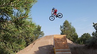
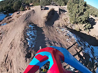
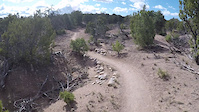
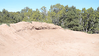
Photos of La Tierra Mountain Bike
Videos of La Tierra Mountain Bike
trail: Trash Pit Booters
2:06 |
571 |
Jul 30, 2021
trail: Trash Pit Booters
0:17 |
412 |
Dec 7, 2020
trail: Yippe Callé
17:41 |
380 |
Apr 11, 2018
trail: Yippe Callé
0:30 |
|
Mar 30, 2017
trail: Tapout
0:52 |
529 |
Oct 16, 2014
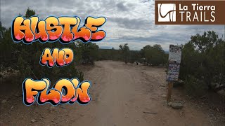
trail: Hustle and Flow
4:49 |
590 |
Jul 12, 2022 , Santa Fe

trail: The Whoops
4:45 |
780 |
Jul 12, 2022 , Santa Fe

trail: Hustle and Flow
7:48 |
488 |
Oct 27, 2021 , Santa Fe
Recent Trail Reports
| status | trail | date | condition | info | user |
|---|---|---|---|---|---|
| Autobahn | Jun 17, 2026 @ 11:24am (America/Ciudad_Juarez) Jun 17, 2026 | Dry | shindog1961 | ||
| Uno | Jun 17, 2026 @ 11:24am (America/Ciudad_Juarez) Jun 17, 2026 | Very Dry | shindog1961 | ||
| North Boundary | Jun 17, 2026 @ 11:24am (America/Ciudad_Juarez) Jun 17, 2026 | Dry | shindog1961 | ||
| Cruise Line | Jun 17, 2026 @ 11:24am (America/Ciudad_Juarez) Jun 17, 2026 | Dry | shindog1961 | ||
| Outer Limits | Jun 17, 2026 @ 11:24am (America/Ciudad_Juarez) Jun 17, 2026 | Dry | shindog1961 | ||
| Outer Limits | Jun 17, 2026 @ 11:24am (America/Ciudad_Juarez) Jun 17, 2026 | Ideal | shindog1961 | ||
| Red Dawg | Jun 13, 2026 @ 9:04am (America/Denver) Jun 13, 2026 | Dry | nicolecopti | ||
| Escalator | Jun 13, 2026 @ 9:04am (America/Denver) Jun 13, 2026 | Very Dry | nicolecopti | ||
| Snake Alley #12 - #14 | Jun 13, 2026 @ 9:04am (America/Denver) Jun 13, 2026 | Very Dry | nicolecopti | ||
| Venus Express | Jun 13, 2026 @ 9:04am (America/Denver) Jun 13, 2026 | Very Dry | nicolecopti |
Activity Feed
| username | action | type | title | date |
|---|---|---|---|---|
| Henry5cDsh6 | wishlist | route | activity #97415337 | Jun 20, 2026 @ 11:12am 1 hours |
| sb666 | wishlist | trail | activity #97296445 | Jun 18, 2026 @ 9:42pm 2 days |
| Drewoowoo | wishlist | route | activity #97294076 | Jun 18, 2026 @ 8:25pm 2 days |
| shindog1961 | add | report | activity #97277659 and 5 more | Jun 18, 2026 @ 2:57pm 2 days |
| shindog1961 | wishlist | route | activity #97084182 | Jun 15, 2026 @ 7:58pm Jun 15, 2026 |
Recent Comments
| username | type | title | comment | date |
|---|---|---|---|---|
| trail | one way now! | Jun 10, 2026 @ 11:02am Jun 10, 2026 | ||
| trail | The detail section says that this is the most... | Mar 3, 2026 @ 4:06pm Mar 3, 2026 | ||
| trail | Not an official trail. Unmarked intersection.... | Mar 3, 2026 @ 4:04pm Mar 3, 2026 | ||
| trail | Best trail in LT. XC heaven. | Jan 13, 2026 @ 11:58am Jan 13, 2026 | ||
| trail | Too steep in many areas which causes lots of... | Dec 18, 2025 @ 10:19am Dec 18, 2025 |
Nearby Areas
| name | distance | ||||
|---|---|---|---|---|---|
| Aldea | 5 | 1 | 3.3 km | ||
| Dale Ball | 5 | 62 | 4 | 3.8 km | |
| Arroyo Hondo Open Space | 1 | 4 | 6.6 km | ||
| Arroyo Hondo USFS | 2 | 12 | 8 | 7.8 km | |
| Santa Fe Mountains | 1 | 20 | 15 | 3 | 9 km |
Local Badges
-

Completionist1 awarded
Bike & Skill Parks
| name | type | city | rating |
|---|---|---|---|
| La Tierra Dirt Jumps | skill park | Santa Fe | |
| La Tierra Freeride Jump Park | skill park | Santa Fe | |
| Buckman MX Track | skill park | Santa Fe |
Local Mountain Biking Directory
-
Santa Fe Fat Tire Society
![Santa Fe Fat Tire Society]()
-
Glorieta Adventure Camps
![Glorieta Adventure Camps]()
-
The Broken SpokeBike Shop
![The Broken Spoke]()
-
Mellow VeloBike Shop
![Mellow Velo]()
-
New Mexico Bike N SportBike Shop
-
Rob And Charlie's Bike ShopBike Shop
Activity Type Stats
| activitytype | trails | distance | descent | descent distance | total vertical | rating | global rank | state rank | photos | reports | routes | ridelogs |
|---|---|---|---|---|---|---|---|---|---|---|---|---|
| Mountain Bike | 74 | 34 miles | 3,294 ft | 14 miles | 466 ft | #316 | #116 | 45 | 1,734 | 9 | 15,826 | |
| E-Bike | 74 | 34 miles | 3,294 ft | 14 miles | 466 ft | #2,321 | #779 | 1 | 1,608 | 637 | ||
| Hike | 76 | 32 miles | 2,917 ft | 13 miles | 466 ft | #920 | #469 | 1,717 | 312 | |||
| Trail Running | 76 | 32 miles | 2,917 ft | 13 miles | 466 ft | #2,641 | #652 | 1,717 | 1,443 |
Frequently Asked Questions About La Tierra
▼
What are the highest rated mountain biking trails in La Tierra?
The highest rated mountain biking trails in La Tierra are:
- Hustle and Flow (4.3/5)
- The Whoops (4.1/5)
- Xavi's Hustle (4.1/5)
- Tapout (4.1/5)
- Rusty Barrel (4.1/5)
▼
What is the best time of the year to ride in La Tierra?
Based on ride log data, the most popular months to ride in La Tierra are:
- July (248 activities)
- August (191 activities)
- May (161 activities)
▼
Where can I park to ride in La Tierra?
There are 8 parking locations listed in La Tierra. The most popular parking spots are: View all parking and trailhead locations on the map to plan your visit.
▼
What is the longest trail in La Tierra?
The longest trail in La Tierra is Pipeline Road at 3.2 km. View all trails sorted by distance.
Activities
Trails
Points of Interest
- By chuktA
 TRAILFORKS NFTA & contributors
 - Admins: SFFTS, SFFTS, SFFTS
- #6455 - 23,406 views
- la tierra activity log | embed map of La Tierra mountain bike trails | la tierra mountain biking points of interest
Downloading of trail gps tracks in kml & gpx formats is enabled for La Tierra.
You must login to download files.