close
-
Layers w
- Weather Layers
- Pro
- Pro
- Pro
- Pro
- Pro
- Pro
- More Layers
- Pro
- Pro
- Pro
- Pro
-
Upgrade to

3D
Trail Conditions
- Unknown
- Snow Groomed
- Snow Packed
- Snow Covered
- Snow Cover Partial
- Freeze/thaw Cycle
- Icy
- Prevalent Mud
- Wet
- Variable
- Ideal
- Dry
- Very Dry
Trail Flow (Ridden Direction)
Trailforks scans users ridelogs to determine the most popular direction each trail is ridden. A good flowing trail network will have most trails flowing in a single direction according to their intension.
The colour categories are based on what percentage of riders are riding a trail in its intended direction.
The colour categories are based on what percentage of riders are riding a trail in its intended direction.
- > 96%
- > 90%
- > 80%
- > 70%
- > 50%
- < 50%
- bi-directional trail
- no data
Trail Last Ridden
Trailforks scans ridelogs to determine the last time a trail was ridden.
- < 2 days
- < 1 week
- < 2 weeks
- < 1 month
- < 6 months
- > 6 months
Trail Ridden Direction
The intended direction a trail should be ridden.
- Downhill Only
- Downhill Primary
- Both Directions
- Uphill Primary
- Uphill Only
- One Direction
Contribute Details
Colors indicate trail is missing specified detail.
- Description
- Photos
- Description & Photos
- Videos
Trail Popularity ?
Trailforks scans ridelogs to determine which trails are ridden the most in the last 9 months.
Trails are compared with nearby trails in the same city region with a possible 25 colour shades.
Think of this as a heatmap, more rides = more kinetic energy = warmer colors.
- most popular
- popular
- less popular
- not popular
ATV/ORV/OHV Filter
Max Vehicle Width
inches
US Cell Coverage
Legend

Radar Time
Activity Recordings
Trailforks uses anonymized public activity data.
?
Activity Recordings
Trailforks uses anonymized public activity data.
?
Personal Heatmap
▶
Activity Types
all
/
none
▶
Options
2
Date range
month
–
Winter Trails
Warning
A routing network for winter maps does not exist. Selecting trails using the winter trails layer has been disabled.
Missing Trails
Most Popular
Least Popular
Trails are colored based on popularity. The more popular a trail is, the more red. Less popular trails trend towards green.
Jump Magnitude Heatmap
Heatmap of where riders jump on trails. Zoom in to see individual jumps, click circles to view jump details.
BC Backroad Status
![map legend]()
Service Road Atlas is a free to use, community-driven service for viewing and creating reports on the numerous back-country service roads around B.C. and Alberta.

Slope Aspect
Direction the slope faces
Trails Deemphasized
Trails are shown in grey.
Only show trails with no bike usage.
Suggested Layers
Based on selected activity type
Save the current map location and zoom level as your default home location whenever this page is loaded.
Save
No description for Laguna Seca has been added yet!
Login or register to submit one.
 google parking directions
AKA: Sea Otter Festival
google parking directions Activities Click to view
- Mountain Bike
8 trails
- Hike
7 trails
- Trail Running
7 trails
Region Details
- 5
- 1
- 2
Region Status
Open as of May 8, 2026Stats
- Avg Trail Rating
- Trails (view details)
- 8
- Trails Mountain Bike
- 8
- Trails Hike
- 7
- Trails Trail Running
- 7
- Total Distance
- 2 miles
- Total Descent
- 683 ft
- Total Vertical
- 514 ft
- Highest Trailhead
- 925 ft
- Reports
- 75
- Photos
- 1,695
- Ridden Counter
- 2,660
Articles

The Privateer: Back on Track at The First Enduro Race of the Season
Jul 4, 2019 from pinkbike.com
Adam heads to California for the first enduro race of the season at the Sea Otter Classic and then makes his way to Santa Cruz to ride with local...
Popular Laguna Seca Mountain Biking Trails
• 75 ★ 3.7 • 1 mile • 25 ft • 540 •
Popular black diamond difficulty singletrack. This mountain bike primary trail can be used downhill primary. On average it takes 15 minutes to complete this trail.
• 10 ★ 5.0 • 753 ft • 3 ft • 321 •
World Class Dual Slalom course open each year during the Sea Otter Classic only for racing.
• 20 ★ 0.0 • 1,040 ft • 54 ft • 262 •
Less popular green difficulty singletrack. This mountain bike primary trail can be used uphill primary. On average it takes 3 minutes to complete this trail.
Laguna Seca Mountain Bike Routes
20 miles • 2,657 ft • 6 •
This is the course for the Sea Otter Classic Fuego XC mountain bike race on April 13, 2025.
20 miles • 2,877 ft • 6 •
Fuego XC 2024 Route https://www.plotaroute.com/route/2243033
10 miles • 1,406 ft • 4 • Loop •
This route is intended for adaptive riders but is suitable for anyone. Adaptive riders, there is only one...
24 miles • 3,301 ft • 7 •
Except for the start and finish on the Laguna Seca Racetrack, this is the course for the 2025 Sea Otter...
26 miles • 2,550 ft • 17 •
....................................................................
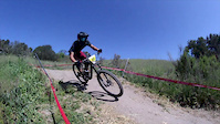
Photos of Laguna Seca Mountain Bike
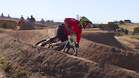
Videos of Laguna Seca Mountain Bike
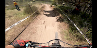
trail: Sea Otter Classic DH Course
0:24 |
2787 |
Jun 1, 2019
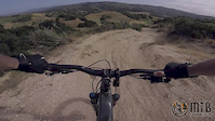
trail: Sea Otter Classic DH Course
3:42 |
608 |
May 30, 2019
0:06 |
398 |
May 10, 2019
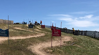
trail: Sea Otter Classic DH Course
2:47 |
878 |
Jul 15, 2018

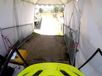
trail: Sea Otter Classic DH Course
3:12 |
373 |
May 8, 2018
trail: Sea Otter Classic DH Course
4:10 |
150 |
Apr 25, 2018
trail: Sea Otter Classic DH Course
3:55 |
150 |
Apr 23, 2018
3:29 |
275 |
Apr 22, 2018
Recent Trail Reports
| status | trail | date | condition | info | user |
|---|---|---|---|---|---|
| Sea Otter Classic DH Course | Apr 10, 2025 @ 3:15pm Apr 10, 2025 | Ideal | Baunty | ||
| Climb Trail | Apr 19, 2023 @ 10:14pm Apr 19, 2023 | Ideal | bravotango81 |
Activity Feed
| username | action | type | title | date |
|---|---|---|---|---|
| Shmeka | wishlist | route | activity #93962236 | May 3, 2026 @ 10:35am May 3, 2026 |
| Creepermonkey | wishlist | route | activity #93453062 and 2 more | Apr 26, 2026 @ 9:44am Apr 26, 2026 |
| SEWYNG | wishlist | route | activity #93079570 | Apr 21, 2026 @ 7:37am Apr 21, 2026 |
| marcmmtthomas | wishlist | route | activity #92946362 | Apr 19, 2026 @ 7:17am Apr 19, 2026 |
| z2CROL | wishlist | trail | activity #92774012 | Apr 17, 2026 @ 1:18am Apr 17, 2026 |
Recent Comments
| username | type | title | comment | date |
|---|---|---|---|---|
| trail | This open? Anybody… bueler | Apr 6, 2023 @ 6:12pm Apr 6, 2023 | ||
| trail | Fun trail. Too bad it’s only opened for Sea... | Oct 8, 2021 @ 5:25pm Oct 8, 2021 | ||
| trail | Fun, fast and windy | Apr 20, 2017 @ 9:12pm Apr 20, 2017 | ||
| trail | Pretty big jumps, nothing too technical...fun ride | Apr 20, 2017 @ 9:11pm Apr 20, 2017 | ||
| trail | fun | Apr 23, 2015 @ 7:57pm Apr 23, 2015 |
Nearby Areas
| name | distance | ||||
|---|---|---|---|---|---|
| Fort Ord National Monument | 66 | 19 | 2 | 3.1 km | |
| Happy Trails | 85 | 4 | 4.2 km | ||
| Toro Regional Park | 4 | 15 | 5 | 1 | 5.3 km |
| Garland Ranch Regional Park | 10 | 1 | 7.2 km | ||
| Bottchers Recreation Site | 16.2 km |
Bike & Skill Parks
| name | type | city | rating |
|---|---|---|---|
| Skills Zone | skill park | Monterey | |
| Kids' Zone | skill park | Monterey |
Upcoming Local Events
Activity Type Stats
| activitytype | trails | distance | descent | descent distance | total vertical | rating | global rank | state rank | photos | reports | routes | ridelogs |
|---|---|---|---|---|---|---|---|---|---|---|---|---|
| Mountain Bike | 8 | 2 miles | 682 ft | 1 mile | 515 ft | #8,256 | #3,212 | 1,708 | 63 | 25 | 4,116 | |
| Hike | 7 | 1 mile | 174 ft | 1,834 ft | 148 ft | #12,149 | #5,007 | 70 | 93 | |||
| Trail Running | 7 | 1 mile | 174 ft | 1,834 ft | 148 ft | #11,338 | #4,375 | 68 | 45 |
Frequently Asked Questions About Laguna Seca
▼
What are the highest rated mountain biking trails in Laguna Seca?
The highest rated mountain biking trails in Laguna Seca are:
- Sea Otter Classic Dual Slalom Course (4.1/5)
- Sea Otter Classic DH Course (3.8/5)
- Climb Trail (0/5)
▼
What is the best time of the year to ride in Laguna Seca?
Based on ride log data, the most popular months to ride in Laguna Seca are:
- April (18 activities)
- July (3 activities)
- October (1 activities)
▼
Where can I park to ride in Laguna Seca?
There are 3 parking locations listed in Laguna Seca. The most popular parking spots are: View all parking and trailhead locations on the map to plan your visit.
▼
What is the longest trail in Laguna Seca?
The longest trail in Laguna Seca is Sea Otter Classic DH Course at 1.0 mile. View all trails sorted by distance.
Activities
Trails
Points of Interest
- By brenthillier
 NSMBA TRAILFORKS & contributors
 - Admins: MORCA, SOC, SOC
- #8299 - 14,017 views
- laguna seca activity log | embed map of Laguna Seca mountain bike trails | laguna seca mountain biking points of interest polygons
Downloading of trail gps tracks in kml & gpx formats is enabled for Laguna Seca.
You must login to download files.