close
-
Layers w
- Weather Layers
- Pro
- Pro
- Pro
- Pro
- Pro
- Pro
- More Layers
- Pro
- Pro
- Pro
- Pro
-
Upgrade to

3D
Trail Conditions
- Unknown
- Snow Groomed
- Snow Packed
- Snow Covered
- Snow Cover Partial
- Freeze/thaw Cycle
- Icy
- Prevalent Mud
- Wet
- Variable
- Ideal
- Dry
- Very Dry
Trail Flow (Ridden Direction)
Trailforks scans users ridelogs to determine the most popular direction each trail is ridden. A good flowing trail network will have most trails flowing in a single direction according to their intension.
The colour categories are based on what percentage of riders are riding a trail in its intended direction.
The colour categories are based on what percentage of riders are riding a trail in its intended direction.
- > 96%
- > 90%
- > 80%
- > 70%
- > 50%
- < 50%
- bi-directional trail
- no data
Trail Last Ridden
Trailforks scans ridelogs to determine the last time a trail was ridden.
- < 2 days
- < 1 week
- < 2 weeks
- < 1 month
- < 6 months
- > 6 months
Trail Ridden Direction
The intended direction a trail should be ridden.
- Downhill Only
- Downhill Primary
- Both Directions
- Uphill Primary
- Uphill Only
- One Direction
Contribute Details
Colors indicate trail is missing specified detail.
- Description
- Photos
- Description & Photos
- Videos
Trail Popularity ?
Trailforks scans ridelogs to determine which trails are ridden the most in the last 9 months.
Trails are compared with nearby trails in the same city region with a possible 25 colour shades.
Think of this as a heatmap, more rides = more kinetic energy = warmer colors.
- most popular
- popular
- less popular
- not popular
ATV/ORV/OHV Filter
Max Vehicle Width
inches
US Cell Coverage
Legend

Radar Time
Activity Recordings
Trailforks uses anonymized public activity data.
?
Activity Recordings
Trailforks uses anonymized public activity data.
?
Personal Heatmap
▶
Activity Types
all
/
none
▶
Options
2
Date range
month
–
Winter Trails
Warning
A routing network for winter maps does not exist. Selecting trails using the winter trails layer has been disabled.
Missing Trails
Most Popular
Least Popular
Trails are colored based on popularity. The more popular a trail is, the more red. Less popular trails trend towards green.
Jump Magnitude Heatmap
Heatmap of where riders jump on trails. Zoom in to see individual jumps, click circles to view jump details.
BC Backroad Status
![map legend]()
Service Road Atlas is a free to use, community-driven service for viewing and creating reports on the numerous back-country service roads around B.C. and Alberta.

Slope Aspect
Direction the slope faces
Trails Deemphasized
Trails are shown in grey.
Only show trails with no bike usage.
Suggested Layers
Based on selected activity type
Save the current map location and zoom level as your default home location whenever this page is loaded.
Save
No description for Lake County has been added yet!
Login or register to submit one.
Activities Click to view
- Mountain Bike
88 trails
- E-Bike
19 trails
- Hike
91 trails
- Trail Running
91 trails
Stats
- Avg Trail Rating
- Trails (view details)
- 94
- Trails Mountain Bike
- 88
- Trails E-Bike
- 19
- Trails Horse
- 1
- Trails Hike
- 91
- Trails Trail Running
- 91
- Trails Nordic Ski
- 1
- Total Distance
- 191 miles
- Total Descent
- 30,027 ft
- Total Vertical
- 6,576 ft
- Highest Trailhead
- 6,843 ft
- Reports
- 234
- Photos
- 88
- Ridden Counter
- 6,113
Sub Regions
- Cobb (40)
- Boggs Mountain (39)
- Hidden Valley Lake (7)
- Six Sigma Ranch (7)
- Lakeport (17)
Popular Lake County Mountain Biking Trails
• 100 ★ 2.0 • 2,018 ft • 28 ft • 292 •
Popular blue difficulty singletrack. This multi-use trail can be used both directions. On average it takes 2 minutes to complete this trail.
• 75 ★ 4.0 • 3 miles • 371 ft • 275 •
Popular blue difficulty singletrack. This multi-use trail can be used both directions. On average it takes 13 minutes to complete this trail.
• 95 ★ 3.4 • 4,167 ft • 98 ft • 256 •
Popular green difficulty doubletrack. This mountain bike primary trail can be used both directions and has a moderate overall physical rating with a 98 ft green climb. On average it takes 6 minutes to complete this trail.
• 100 ★ 3.0 • 2,598 ft • 150 ft • 231 •
Popular blue difficulty doubletrack. This mountain bike primary trail can be used uphill primary and has a easy overall physical rating with a 150 ft green climb. On average it takes 5 minutes to complete this trail.
• 100 ★ 4.5 • 4,603 ft • 167 ft • 229 •
Popular blue difficulty doubletrack. This mountain bike primary trail can be used downhill primary. On average it takes 7 minutes to complete this trail.
• 90 ★ 2.0 • 853 ft • 43 ft • 228 •
Popular blue difficulty singletrack. This multi-use trail can be used both directions. On average it takes 2 minutes to complete this trail.
• 90 ★ 3.0 • 4,272 ft • 57 ft • 216 •
Great singlrtrack climb to incredible views of the surrounding area. **Note this entire area was heavily damaged during last year's fires. The entire mountain is closed until further notice and will require considerable rebuild of all...
Lake County Mountain Bike Routes
12 miles • 1,727 ft • 15 • Loop •
This 12 mile loop includes two newly opened trails for a full tour of the whole park. Start at the base...
★ 1.0 • 6 miles • 748 ft • 12 •
A great way to see most of the restored trails. Fun either direction!
12 miles • 1,724 ft • 30 • Loop •
Two loops on the New Single track at Boggs mountain. This loop has about 1300 ft. of climbing, fast...
138 miles • 19,610 ft • 2 • Loop •
THE RIDE: We will do a loop starting out of potter valley up past lake pillsbury taking M3 for a little...
★ 1.0 • 6 miles • 821 ft • 4 • Loop • Race •
2022 NorCal NICA Championship race route
15 miles • 1,465 ft • 1 • Loop • Race •
This is the official race course for the Six Sigma 60 and will be added to the event page.
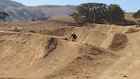
Photos of Lake County Mountain Bike
Videos of Lake County Mountain Bike

trail: Lake Trail
7:59 |
25 |
Oct 31, 2020
trail: Lake Trail
0:13 |
228 |
Oct 30, 2020
trail: Lake Trail
10:28 |
21 |
May 29, 2020
trail: Lake Trail
2:49 |
12 |
May 29, 2020
trail: Lake Trail
2:38 |
10 |
May 29, 2020
trail: Lake Trail
0:46 |
10 |
May 29, 2020
trail: Lake Trail
2:23 |
11 |
May 29, 2020
trail: Lake Trail
2:57 |
22 |
May 29, 2020
Recent Trail Reports
Activity Feed
| username | action | type | title | date |
|---|---|---|---|---|
| trailforks | add | video | activity #97196482 | Jun 17, 2026 @ 11:00am 1 day |
| repackracing | update | event | activity #97102875 | Jun 16, 2026 @ 5:44am 2 days |
| repackracing | add | route | activity #97102120 | Jun 16, 2026 @ 5:28am 2 days |
| trailforks | add | video | activity #96688243 | Jun 10, 2026 @ 12:00pm Jun 10, 2026 |
| trailforks | add | video | activity #96676647 | Jun 10, 2026 @ 9:00am Jun 10, 2026 |
Recent Comments
| username | type | title | comment | date |
|---|---|---|---|---|
| trail | Some fun stuff to hop off throughout the upper... | Apr 27, 2026 @ 10:29am Apr 27, 2026 | ||
| trail | Nice easy climb but more fun top to bottom. ... | Dec 15, 2025 @ 10:54am Dec 15, 2025 | ||
| trail | What do you mean? Are the features gone? | Nov 5, 2025 @ 12:50pm Nov 5, 2025 | ||
| trail | Sadly they destroyed all the good work when... | Jul 20, 2025 @ 5:18pm Jul 20, 2025 | ||
| trail | This is not a black at all but a green trail... | Jan 7, 2024 @ 10:10am Jan 7, 2024 |
Local Badges
-

Epic Ride Descent 2k9 awarded -

Completionist0 awarded -

Epic Mountain Bike Climb 2k9 awarded -

Climbing 10k Badge2 awarded -

Mountain Biking 100k Badge0 awarded -

Descent 100k Badge0 awarded
Bike & Skill Parks
| name | type | city | rating |
|---|---|---|---|
| Oasis Motocross | skill park | Lakeport | |
| stonyford- davis flat | skill park | Lakeport |
Upcoming Local Events
Activity Type Stats
| activitytype | trails | distance | descent | descent distance | total vertical | rating | global rank | state rank | photos | reports | routes | ridelogs |
|---|---|---|---|---|---|---|---|---|---|---|---|---|
| Mountain Bike | 88 | 178 miles | 26,624 ft | 79 miles | 4,429 ft | 80 | 234 | 6 | 6,393 | |||
| E-Bike | 19 | 75 miles | 14,154 ft | 40 miles | 2,425 ft | 182 | 244 | |||||
| Horse | 1 | 3 miles | 919 ft | 3 miles | 886 ft | 60 | 3 | |||||
| Hike | 91 | 191 miles | 30,026 ft | 86 miles | 6,575 ft | 8 | 234 | 959 | ||||
| Trail Running | 91 | 191 miles | 30,026 ft | 86 miles | 6,575 ft | 234 | 41 | |||||
| Nordic Ski | 1 | 4 miles | 528 ft | 2 miles | 502 ft | 1 |
Frequently Asked Questions About Lake County
▼
What are the best places to ride in Lake County?
Lake County has 4 areas to explore for mountain biking. The top rated areas are:
▼
What are the highest rated mountain biking trails in Lake County?
The highest rated mountain biking trails in Lake County are:
- Jethros Trail (4.2/5)
- Gail's Trail (4/5)
- Game Trail (4/5)
- Kaj's Winery Trail (4/5)
- The Edge (4/5)
▼
What is the best time of the year to ride in Lake County?
Based on ride log data, the most popular months to ride in Lake County are:
- May (35 activities)
- February (31 activities)
- March (18 activities)
▼
What is the longest trail in Lake County?
The longest trail in Lake County is Cache Creek Ridge Trail at 9.5 miles. View all trails sorted by distance.
Activities
Trails
- By brenthillier
 NSMBA TRAILFORKS & contributors
 - Admins: jpmcghee, sanfret, brianpetry, REMBA
- #7924 - 6,227 views
- lake county activity log | embed map of Lake County mountain bike trails | lake county mountain biking points of interest
Downloading of trail gps tracks in kml & gpx formats is enabled for Lake County.
You must login to download files.