close
-
Layers w
- Weather Layers
- Pro
- Pro
- Pro
- Pro
- Pro
- Pro
- More Layers
- Pro
- Pro
- Pro
- Pro
-
Upgrade to

3D
Trail Conditions
- Unknown
- Snow Groomed
- Snow Packed
- Snow Covered
- Snow Cover Partial
- Freeze/thaw Cycle
- Icy
- Prevalent Mud
- Wet
- Variable
- Ideal
- Dry
- Very Dry
Trail Flow (Ridden Direction)
Trailforks scans users ridelogs to determine the most popular direction each trail is ridden. A good flowing trail network will have most trails flowing in a single direction according to their intension.
The colour categories are based on what percentage of riders are riding a trail in its intended direction.
The colour categories are based on what percentage of riders are riding a trail in its intended direction.
- > 96%
- > 90%
- > 80%
- > 70%
- > 50%
- < 50%
- bi-directional trail
- no data
Trail Last Ridden
Trailforks scans ridelogs to determine the last time a trail was ridden.
- < 2 days
- < 1 week
- < 2 weeks
- < 1 month
- < 6 months
- > 6 months
Trail Ridden Direction
The intended direction a trail should be ridden.
- Downhill Only
- Downhill Primary
- Both Directions
- Uphill Primary
- Uphill Only
- One Direction
Contribute Details
Colors indicate trail is missing specified detail.
- Description
- Photos
- Description & Photos
- Videos
Trail Popularity ?
Trailforks scans ridelogs to determine which trails are ridden the most in the last 9 months.
Trails are compared with nearby trails in the same city region with a possible 25 colour shades.
Think of this as a heatmap, more rides = more kinetic energy = warmer colors.
- most popular
- popular
- less popular
- not popular
ATV/ORV/OHV Filter
Max Vehicle Width
inches
US Cell Coverage
Legend

Radar Time
Activity Recordings
Trailforks uses anonymized public activity data.
?
Activity Recordings
Trailforks uses anonymized public activity data.
?
Personal Heatmap
▶
Activity Types
all
/
none
▶
Options
2
Date range
month
–
Winter Trails
Warning
A routing network for winter maps does not exist. Selecting trails using the winter trails layer has been disabled.
Missing Trails
Most Popular
Least Popular
Trails are colored based on popularity. The more popular a trail is, the more red. Less popular trails trend towards green.
Jump Magnitude Heatmap
Heatmap of where riders jump on trails. Zoom in to see individual jumps, click circles to view jump details.
BC Backroad Status
![map legend]()
Service Road Atlas is a free to use, community-driven service for viewing and creating reports on the numerous back-country service roads around B.C. and Alberta.

Slope Aspect
Direction the slope faces
Trails Deemphasized
Trails are shown in grey.
Only show trails with no bike usage.
Suggested Layers
Based on selected activity type
Save the current map location and zoom level as your default home location whenever this page is loaded.
SaveTrails marked as 'Moto Primary' are considered two stars or less and not ideal for MTB
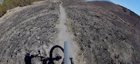
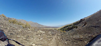
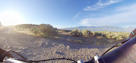
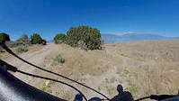
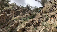
Lake Mountains mountain biking, south of Eagle Mountain Center and west of Utah Lake, is the “wild wild west” of adventure mountain biking—away from the crowds and carpet trails; home to dirt-bikers, rattlesnakes, annoying bugs, and difficult approaches. The trails are moto trails—NOT mtb specific, so the trails can be STEEP, rough, loose, rocky, and dangerous; Terminal Velocity has a continual grade of 35-40% This is not an area for beginners or riders that prefer mtb specific trails.
For mtb, the area is very challenging. It has some of the most gnarly downhills in the SLC area like The Punisher—in the running for the most savage trail in Utah, and Gravity Well which drops have been considered "upper fire swamp scary!" This is just the beginning, the area has a tons of possible lines waiting to be explored and established.
More Mtb infrastructure is in the works to mitigate some of the current hard approaches. Trail building contributors are welcome! In the future, there will be climb-up trails for getting to the top of Overwatch , Gravity Well, and The Punisher. Currently, trails with better approaches like Jakarta are on the sunrise/lake side of the Lake Mountains.
High clearance vehicles are recommended for getting to the closest parking areas to the trails. When riding the Overwatch area, Access Road 2 is the best road to use.
There is a wire BLM cattle gate on Access Road 2 ; please close the gate when entering and leaving the area.
When we are out there riding, let’s make the area better for everyone by moving any obvious dangerous rocks off the trail where it makes sense.
Gnar trails easiest to hardest (does not include all trails)
Bandit (access from Luna side)
Tapeworm
Overwatch (use the Overwatch Loop Route and SE ridge as an in-and-out)
Jakarta
Drifter
Neverwinter when including Warhammer
Cascade
Cracked Cassette
Machete
Bike Sushi
Gravity Well
Gravity Well including Ladies First
Terminal Velocity including Ladies First
The Punisher
Rebel Yell (15+ foot huck off a cliff)
Primary Trail Type: All-Mountain & Downhill
eBikes Allowed:
Yes
Shuttleable: YES
AKA: Soldier Pass
 google parking directions
 Activities Click to view
- Mountain Bike
208 trails
- E-Bike
218 trails
- Horse
105 trails
- Hike
198 trails
- Trail Running
192 trails
- Dirtbike/Moto
199 trails
- Observed Trials
45 trails
- ATV/ORV/OHV
59 trails
Region Details
- 43
- 21
- 57
- 40
- 15
- 1
Region Status
Open as of Mar 14, 2026Stats
- Avg Trail Rating
- Trails (view details)
- 177
- Trails Mountain Bike
- 209
- Trails E-Bike
- 218
- Trails Gravel Bike
- 1
- Trails Winter Fat Bike
- 5
- Trails Horse
- 105
- Trails Hike
- 198
- Trails Trail Running
- 192
- Trails Dirtbike/Moto
- 202
- Trails Observed Trials
- 45
- Trails ATV/ORV/OHV
- 59
- Total Distance
- 149 miles
- Total Descent
- 25,069 ft
- Total Vertical
- 3,033 ft
- Highest Trailhead
- 7,673 ft
- Reports
- 274
- Photos
- 496
- Ridden Counter
- 8,000
Popular Lake Mountains Mountain Biking Trails
• 65 ★ 3.9 • 2 miles • 84 ft • 105 •
Right at the beginning there is a very small HAB section. After that, the trail is very ridable steady grade to the downhill section. The “Jburnt Canyon” downhill section is more technical than Overwatch, and some will find it even...
• 55 ★ 3.0 • 1 mile • 454 ft • 96 •
Perfect climbing grade on this trail to access . It begins as single track, then turns into double track.
• 55 ★ 4.3 • 1 mile • 8 ft • 71 •
is an amazing long technical downhill with incredible views. Towards the bottom it can get really rocky. At the bottom you can branch right to the short trail " " for a 6 to 10 foot drop depending on how fast you take it. On you are...
• 35 ★ 1.0 • 1,102 ft • 338 ft • 57 • • moto
This is the climb to access the descent! This climb is difficult, but downhill is amazing! Watch out for rattlesnakes!
• 65 ★ 3.0 • 1 mile • 172 ft • 55 •
Access trail to and other future trails in . When you get to top of there is a steep gully near bottom of , climbing you will take a 90 degree left (North) on the West side of the gulley to continue your climb to by way of .
• 65 ★ 2.5 • 4,400 ft • 88 ft • 50 • • atv
Access Jeep road between area and Wildcat Canyon. It's more physically demanding when heading north on it.
• 45 ★ 5.0 • 2,247 ft • 0 ft • 50 •
Some fun fast sections with a techy rock garden where the trail goes to the right. Nice detour off of .
• 40 ★ 4.0 • 275 ft • 0 ft • 48 •
This short trail branches off of the bottom of for the 6 to 10 foot drop depending on how fast you go off of it. It's a very technical drop because you first have to deal with a 1 to 2 foot drop only a couple of feet before launching...
Lake Mountains Mountain Bike Routes
Jakarta Lollypop Loop Featured
★ 3.5 • 6 miles • 1,217 ft • 4 • Loop •
This is a nice route to experience the trail. Parking is relatively easy on a dirt road (2wd friendly)....
★ 3.0 • 3 miles • 828 ft • 4 •
Overwatch is the gem of the West Lake system. A gnarly downhill, and the climb up the fire road is not bad...
17 miles • 2,788 ft • 2 • Out & Back •
This is a 16 mile ride covering 2800 vertical feet.
6 miles • 1,306 ft • 14 •
This is the recommended route to access Gravity Well. Climbs are mostly fire road at a manageable grade....
6 miles • 1,220 ft • 7 • Loop •
This is a loop on Lake mountains. Three trails, Afro Magic, Pfeifter Canyon, and Jakarta.
Photos of Lake Mountains Mountain Bike
Videos of Lake Mountains Mountain Bike
trail: King in Yellow
0:34 |
101 |
Sep 6, 2020
trail: Tapeworm
0:17 |
145 |
Aug 2, 2020
trail: Cayendo
0:02 |
91 |
Jun 27, 2020
trail: Cayendo
0:58 |
61 |
Jun 20, 2020
trail: Jakarta
0:08 |
677 |
Apr 25, 2020
trail: Good Vibes
0:00 |
75 |
May 27, 2016

trail: Overwatch, West
67 |
Jun 23, 2025 , Eagle Mountain
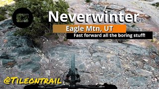
trail: Neverwinter
0:46 |
56 |
Apr 25, 2025 , Eagle Mountain
Recent Trail Reports
| status | trail | date | condition | info | user |
|---|---|---|---|---|---|
| Overwatch, West | Mar 14, 2026 @ 4:19pm (America/Boise) Mar 14, 2026 | Dry | Bociancz | ||
| Access Trail 0 | Mar 14, 2026 @ 4:19pm (America/Boise) Mar 14, 2026 | Dry | Bociancz | ||
| Neverwinter | Mar 14, 2026 @ 4:19pm (America/Boise) Mar 14, 2026 | Dry | Bociancz | ||
| Yoga Pants Blondie | Mar 14, 2026 @ 4:19pm (America/Boise) Mar 14, 2026 | Dry | Bociancz | ||
| Cascade | Mar 14, 2026 @ 4:19pm (America/Boise) Mar 14, 2026 | Dry | Bociancz | ||
| Afro Mystic | Mar 1, 2026 @ 10:22am (America/Denver) Mar 1, 2026 | Dry | codyfrisbymtb | ||
| Jakarta | Mar 1, 2026 @ 10:22am (America/Denver) Mar 1, 2026 | Dry | codyfrisbymtb | ||
| bike sushi | Mar 1, 2026 @ 10:22am (America/Denver) Mar 1, 2026 | Dry | codyfrisbymtb | ||
| Pfeifter Canyon | Mar 1, 2026 @ 10:22am (America/Denver) Mar 1, 2026 | Dry | codyfrisbymtb | ||
| Brutality | Dec 30, 2025 @ 2:34pm (America/Boise) Dec 30, 2025 | Dry | aaronskee |
Activity Feed
| username | action | type | title | date |
|---|---|---|---|---|
| AustinEVLIyC | wishlist | route | activity #95823430 | May 29, 2026 @ 9:51pm May 29, 2026 |
| spenny_rides | wishlist | trail | activity #94732969 | May 14, 2026 @ 10:23pm May 14, 2026 |
| aaronskee | add | photo | activity #94399604 and 2 more | May 9, 2026 @ 10:13pm May 9, 2026 |
| aaronskee | ridden | poi | activity #94399451 | May 9, 2026 @ 10:05pm May 9, 2026 |
| aaronskee | add | poi | activity #94360922 | May 9, 2026 @ 11:09am May 9, 2026 |
Recent Comments
| username | type | title | comment | date |
|---|---|---|---|---|
| trail | My new favorite trail in the area. More... | May 22, 2025 @ 10:17am May 22, 2025 | ||
| trail | Technically this is a dark blue, but it... | Nov 23, 2024 @ 5:06pm Nov 23, 2024 | ||
| trail | Best way to get to neverwinter | Sep 17, 2024 @ 4:37pm Sep 17, 2024 | ||
| trail | Such a sick trail! Can’t believe this gem is... | Sep 17, 2024 @ 4:35pm Sep 17, 2024 | ||
| trail | Such a fun feature to close out Neverwinter | Sep 17, 2024 @ 4:33pm Sep 17, 2024 |
Nearby Areas
| name | distance | ||||
|---|---|---|---|---|---|
| Mountain Ranch Bike Park | 33 | 52 | 22 | 5 | 6.3 km |
| Firefly Mountain Bike Park | 2 | 1 | 1 | 9.3 km | |
| Tickville Hollow | 2 | 9.5 km | |||
| Harvest Hills | 10.5 km | ||||
| Five Mile Pass Motorbike Park | 3 | 3 | 1 | 10.7 km |
Local Badges
-

Completionist0 awarded
Bike & Skill Parks
| name | type | city | rating |
|---|---|---|---|
| Firefly Pump Track | skill park | Eagle Mountain |
Activity Type Stats
| activitytype | trails | distance | descent | descent distance | total vertical | rating | global rank | state rank | photos | reports | routes | ridelogs |
|---|---|---|---|---|---|---|---|---|---|---|---|---|
| Mountain Bike | 208 | 149 miles | 25,069 ft | 65 miles | 3,031 ft | #1,141 | #396 | 450 | 279 | 5 | 1,179 | |
| E-Bike | 218 | 146 miles | 24,091 ft | 63 miles | 3,031 ft | #454 | #583 | 275 | 2 | 393 | ||
| Gravel Bike | 1 | #3,150 | #1,464 | 1 | ||||||||
| Winter Fat Bike | 5 | #3,150 | #1,464 | |||||||||
| Horse | 105 | 85 miles | 8,386 ft | 29 miles | 3,031 ft | #324 | #247 | 138 | ||||
| Hike | 198 | 144 miles | 24,252 ft | 62 miles | 3,031 ft | #433 | #240 | 11 | 279 | 48 | ||
| Trail Running | 192 | 143 miles | 23,550 ft | 61 miles | 3,031 ft | #405 | #174 | 279 | 1 | 232 | ||
| Dirtbike/Moto | 199 | 139 miles | 22,461 ft | 60 miles | 3,031 ft | #16 | #4 | 36 | 202 | 1 | 726 | |
| Observed Trials | 45 | 20 miles | 1,352 ft | 5 miles | 1,762 ft | #42 | #13 | 100 | ||||
| ATV/ORV/OHV | 59 | 65 miles | 4,012 ft | 21 miles | 3,031 ft | #95 | #36 | 110 | 22 |
Frequently Asked Questions About Lake Mountains
▼
What are the highest rated mountain biking trails in Lake Mountains?
The highest rated mountain biking trails in Lake Mountains are:
- Gravity Well (4.4/5)
- The Punisher (4.3/5)
- Drifter (4.2/5)
- Overwatch, West (4.1/5)
- Tangerang (4.1/5)
▼
What is the best time of the year to ride in Lake Mountains?
Based on ride log data, the most popular months to ride in Lake Mountains are:
- October (10 activities)
- April (8 activities)
- March (8 activities)
▼
Where can I park to ride in Lake Mountains?
There are 15 parking locations listed in Lake Mountains. The most popular parking spots are: View all parking and trailhead locations on the map to plan your visit.
▼
What is the longest trail in Lake Mountains?
The longest trail in Lake Mountains is Extra Credit at 7.8 miles. View all trails sorted by distance.
Activities
Trails
- By UtahLakeMountains
 & contributors
 - Admins: LMTA, LMTA, URMB, UVTA
- #29686 - 9,443 views
- lake mountains activity log | embed map of Lake Mountains mountain bike trails | lake mountains mountain biking points of interest
Downloading of trail gps tracks in kml & gpx formats is enabled for Lake Mountains.
You must login to download files.