close
-
Layers w
- Weather Layers
- Pro
- Pro
- Pro
- Pro
- Pro
- Pro
- More Layers
- Pro
- Pro
- Pro
- Pro
-
Upgrade to

3D
Trail Conditions
- Unknown
- Snow Groomed
- Snow Packed
- Snow Covered
- Snow Cover Partial
- Freeze/thaw Cycle
- Icy
- Prevalent Mud
- Wet
- Variable
- Ideal
- Dry
- Very Dry
Trail Flow (Ridden Direction)
Trailforks scans users ridelogs to determine the most popular direction each trail is ridden. A good flowing trail network will have most trails flowing in a single direction according to their intension.
The colour categories are based on what percentage of riders are riding a trail in its intended direction.
The colour categories are based on what percentage of riders are riding a trail in its intended direction.
- > 96%
- > 90%
- > 80%
- > 70%
- > 50%
- < 50%
- bi-directional trail
- no data
Trail Last Ridden
Trailforks scans ridelogs to determine the last time a trail was ridden.
- < 2 days
- < 1 week
- < 2 weeks
- < 1 month
- < 6 months
- > 6 months
Trail Ridden Direction
The intended direction a trail should be ridden.
- Downhill Only
- Downhill Primary
- Both Directions
- Uphill Primary
- Uphill Only
- One Direction
Contribute Details
Colors indicate trail is missing specified detail.
- Description
- Photos
- Description & Photos
- Videos
Trail Popularity ?
Trailforks scans ridelogs to determine which trails are ridden the most in the last 9 months.
Trails are compared with nearby trails in the same city region with a possible 25 colour shades.
Think of this as a heatmap, more rides = more kinetic energy = warmer colors.
- most popular
- popular
- less popular
- not popular
ATV/ORV/OHV Filter
Max Vehicle Width
inches
US Cell Coverage
Legend

Radar Time
Activity Recordings
Trailforks uses anonymized public activity data.
?
Activity Recordings
Trailforks uses anonymized public activity data.
?
Personal Heatmap
▶
Activity Types
all
/
none
▶
Options
2
Date range
month
–
Winter Trails
Warning
A routing network for winter maps does not exist. Selecting trails using the winter trails layer has been disabled.
Missing Trails
Most Popular
Least Popular
Trails are colored based on popularity. The more popular a trail is, the more red. Less popular trails trend towards green.
Jump Magnitude Heatmap
Heatmap of where riders jump on trails. Zoom in to see individual jumps, click circles to view jump details.
BC Backroad Status
![map legend]()
Service Road Atlas is a free to use, community-driven service for viewing and creating reports on the numerous back-country service roads around B.C. and Alberta.

Slope Aspect
Direction the slope faces
Trails Deemphasized
Trails are shown in grey.
Only show trails with no bike usage.
Suggested Layers
Based on selected activity type
Save the current map location and zoom level as your default home location whenever this page is loaded.
SaveLancaster County is currently not well represented by a local trail organizations, although in the northern areas Susquehanna Area Mountain Bike Association maintains trails at Governor Dick and J Edward Mack Scout Reservation. Mountain biking is permitted at Lancaster Central Park, and paved trails are available along the Susquehanna River Trail extending from Bainbridge to Columbia.
Activities Click to view
- Mountain Bike
117 trails
- E-Bike
8 trails
- Horse
31 trails
- Hike
252 trails
- Trail Running
250 trails
- Snowshoe
23 trails
- Nordic Ski
8 trails
Stats
- Avg Trail Rating
- Trails (view details)
- 203
- Trails Mountain Bike
- 145
- Trails E-Bike
- 8
- Trails Gravel Bike
- 1
- Trails Adaptive Bike
- 1
- Trails Horse
- 31
- Trails Hike
- 253
- Trails Trail Running
- 250
- Trails Snowshoe
- 23
- Trails Backcountry Ski
- 1
- Trails Nordic Ski
- 8
- Total Distance
- 182 miles
- Total Descent
- 23,774 ft
- Total Vertical
- 991 ft
- Highest Trailhead
- 1,171 ft
- Reports
- 608
- Photos
- 162
- Ridden Counter
- 8,362
Popular Trail Networks
view all areas »Sub Regions
- Brickerville (2)
- Columbia (0)
- Ephrata (4)
- Lancaster (23)
- Lititz (10)
- New Holland (52)
- Penryn (9)
Popular Lancaster County Mountain Biking Trails
• 95 ★ 3.2 • 2,844 ft • 148 ft • 346 •
Popular blue difficulty doubletrack. This multi-use trail can be used both directions. On average it takes 5 minutes to complete this trail.
• 95 ★ 3.7 • 1,978 ft • 72 ft • 341 •
Popular blue difficulty singletrack. This multi-use trail can be used both directions. On average it takes 2 minutes to complete this trail.
• 100 ★ 4.0 • 3,274 ft • 8 ft • 332 •
Highly rated popular blue difficulty singletrack. This mountain bike primary trail can be used both directions and has a moderate overall physical rating with a 8 ft blue climb. On average it takes 3 minutes to complete this trail.
• 100 ★ 4.3 • 4,764 ft • 155 ft • 321 •
Trail flows well in both directions. It is the best way to access the Camp Mack Trail system when entering from Pumping Station Parking Lot off 322. Was designed and built by Susquehanna Area Mountain Bike Association
• 90 ★ 4.6 • 4,659 ft • 45 ft • 269 •
Fun and flowy downhill. Very enjoyable. Was designed and built by Susquehanna Area Mountain Bike Association.
• 95 ★ 3.8 • 3,714 ft • 77 ft • 259 •
Popular blue difficulty singletrack. This mountain bike primary trail. On average it takes 8 minutes to complete this trail.
• 80 ★ 4.0 • 1,801 ft • 0 ft • 246 •
editing to reflect Shooter's Valley trail as the correct northernmost trail.
Lancaster County Mountain Bike Routes
Camp Mack Ride Plan #1 Featured
13 miles • 1,580 ft • 13 •
A popular route that leaves from the pumping station parking lot on 322. This hits most of the good stuff...
Camp Mack minus eagle rock Featured
★ 2.0 • 11 miles • 1,496 ft • 12 • Loop •
Camp Mack from Pumping station. not including Eagle Rock
★ 4.0 • 10 miles • 1,516 ft • 15 •
Includes 4 climbs: / (going up from Pumping Station Parking) Lower / (going up from Hammer Creek) / over...
Photos of Lancaster County Mountain Bike
Videos of Lancaster County Mountain Bike
trail: Just For Fun
0:07 |
142 |
Dec 31, 2020
trail: Gameland
2:27 |
1205 |
May 6, 2015
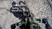
trail: Spring
3:33 |
467 |
Mar 29, 2015
trail: Secret
0:28 |
321 |
Oct 23, 2013
trail: Horseshoe
19:41 |
901 |
Apr 12, 2021 , Lititz

trail: Just For Fun
0:48 |
294 |
Feb 3, 2009
Recent Trail Reports
Activity Feed
| username | action | type | title | date |
|---|---|---|---|---|
| Breeze510 | wishlist | route | activity #97202274 | Jun 17, 2026 @ 12:17pm 2 days |
| AllieW | wishlist | badge | activity #96559839 | Jun 8, 2026 @ 1:06pm Jun 8, 2026 |
| bummienotes | add | report | activity #96510605 and 1 more | Jun 7, 2026 @ 5:32pm Jun 7, 2026 |
| wb3jma | add | report | activity #95899120 | May 30, 2026 @ 5:17pm May 30, 2026 |
| MJGrand | wishlist | route | activity #95861093 | May 30, 2026 @ 9:29am May 30, 2026 |
Recent Comments
| username | type | title | comment | date |
|---|---|---|---|---|
| trail | Very fun trail to practice turns. Very fun... | Jun 23, 2025 @ 5:43pm Jun 23, 2025 | ||
| trail | Trail is open again. | Apr 12, 2025 @ 7:40am Apr 12, 2025 | ||
| trail | Bottom half is nothing but loose rocks! Folks... | Nov 19, 2024 @ 3:17pm Nov 19, 2024 | ||
| trail | Fun short trail that tests your jumping and... | Aug 30, 2024 @ 6:35am Aug 30, 2024 | ||
| trail | Don't bother climbing this trail.. it's steep!... | Jul 8, 2024 @ 9:21am Jul 8, 2024 |
Local Badges
-

Descend 50,000 feet at Camp Mack5 awarded -

10 Green Trails30 awarded -

Epic Ride 50k670 awarded -

Epic Ride Descent 2k0 awarded -

Descent 10k Badge3 awarded -

Descent 100k Badge0 awarded
Bike & Skill Parks
| name | type | city | rating |
|---|---|---|---|
| Heatherwood Bike Park | skill park | Ephrata |
Activity Type Stats
| activitytype | trails | distance | descent | descent distance | total vertical | rating | global rank | state rank | photos | reports | routes | ridelogs |
|---|---|---|---|---|---|---|---|---|---|---|---|---|
| Mountain Bike | 117 | 122 miles | 12,894 ft | 55 miles | 942 ft | 164 | 616 | 8 | 20,082 | |||
| E-Bike | 8 | 35 miles | 427 ft | 12 miles | 853 ft | 434 | 398 | |||||
| Gravel Bike | 1 | 3 | 109 | |||||||||
| Adaptive Bike | 1 | 1 | ||||||||||
| Horse | 31 | 30 miles | 4,567 ft | 14 miles | 922 ft | 183 | ||||||
| Hike | 252 | 181 miles | 23,773 ft | 82 miles | 991 ft | 1 | 619 | 1 | 1,925 | |||
| Trail Running | 250 | 181 miles | 23,484 ft | 82 miles | 991 ft | 616 | 975 | |||||
| Snowshoe | 23 | 18 miles | 3,045 ft | 8 miles | 741 ft | 15 | 37 | |||||
| Backcountry Ski | 1 | 4,370 ft | 7 ft | 482 ft | 246 ft | |||||||
| Nordic Ski | 8 | 7 miles | 1,024 ft | 4 miles | 673 ft | 32 |
Frequently Asked Questions About Lancaster County
▼
What are the best places to ride in Lancaster County?
Lancaster County has 15 areas to explore for mountain biking. The top rated areas are:
▼
What are the highest rated mountain biking trails in Lancaster County?
The highest rated mountain biking trails in Lancaster County are:
- Light (4.3/5)
- Buzzard DH (4.2/5)
- Horseshoe Trail (DBD) (4.2/5)
- Cockscomb Loop (red blaze) (4.2/5)
- Spring (Designated Route) (4.2/5)
▼
What is the best time of the year to ride in Lancaster County?
Based on ride log data, the most popular months to ride in Lancaster County are:
- June (160 activities)
- July (152 activities)
- September (143 activities)
▼
What is the longest trail in Lancaster County?
The longest trail in Lancaster County is Enola Low Grade Trail at 29.3 miles. View all trails sorted by distance.
Activities
Trails
- By PHeller
 FBO & contributors
 - Admins: Turntex, PlumbBobM, SAMBA, LC
- #5515 - 10,496 views
- lancaster county activity log | embed map of Lancaster County mountain bike trails | lancaster county mountain biking points of interest polygons
Downloading of trail gps tracks in kml & gpx formats is enabled for Lancaster County.
You must login to download files.