close
-
Layers w
- Weather Layers
- Pro
- Pro
- Pro
- Pro
- Pro
- Pro
- More Layers
- Pro
- Pro
- Pro
- Pro
-
Upgrade to

3D
Trail Conditions
- Unknown
- Snow Groomed
- Snow Packed
- Snow Covered
- Snow Cover Partial
- Freeze/thaw Cycle
- Icy
- Prevalent Mud
- Wet
- Variable
- Ideal
- Dry
- Very Dry
Trail Flow (Ridden Direction)
Trailforks scans users ridelogs to determine the most popular direction each trail is ridden. A good flowing trail network will have most trails flowing in a single direction according to their intension.
The colour categories are based on what percentage of riders are riding a trail in its intended direction.
The colour categories are based on what percentage of riders are riding a trail in its intended direction.
- > 96%
- > 90%
- > 80%
- > 70%
- > 50%
- < 50%
- bi-directional trail
- no data
Trail Last Ridden
Trailforks scans ridelogs to determine the last time a trail was ridden.
- < 2 days
- < 1 week
- < 2 weeks
- < 1 month
- < 6 months
- > 6 months
Trail Ridden Direction
The intended direction a trail should be ridden.
- Downhill Only
- Downhill Primary
- Both Directions
- Uphill Primary
- Uphill Only
- One Direction
Contribute Details
Colors indicate trail is missing specified detail.
- Description
- Photos
- Description & Photos
- Videos
Trail Popularity ?
Trailforks scans ridelogs to determine which trails are ridden the most in the last 9 months.
Trails are compared with nearby trails in the same city region with a possible 25 colour shades.
Think of this as a heatmap, more rides = more kinetic energy = warmer colors.
- most popular
- popular
- less popular
- not popular
ATV/ORV/OHV Filter
Max Vehicle Width
inches
US Cell Coverage
Legend

Radar Time
Activity Recordings
Trailforks uses anonymized public activity data.
?
Activity Recordings
Trailforks uses anonymized public activity data.
?
Personal Heatmap
▶
Activity Types
all
/
none
▶
Options
2
Date range
month
–
Winter Trails
Warning
A routing network for winter maps does not exist. Selecting trails using the winter trails layer has been disabled.
Missing Trails
Most Popular
Least Popular
Trails are colored based on popularity. The more popular a trail is, the more red. Less popular trails trend towards green.
Jump Magnitude Heatmap
Heatmap of where riders jump on trails. Zoom in to see individual jumps, click circles to view jump details.
BC Backroad Status
![map legend]()
Service Road Atlas is a free to use, community-driven service for viewing and creating reports on the numerous back-country service roads around B.C. and Alberta.

Slope Aspect
Direction the slope faces
Trails Deemphasized
Trails are shown in grey.
Only show trails with no bike usage.
Suggested Layers
Based on selected activity type
Save the current map location and zoom level as your default home location whenever this page is loaded.
Save
No description for Laos has been added yet!
Login or register to submit one.
Region Details
- 1
- 7
- 1
Stats
- Avg Trail Rating
- Trails (view details)
- 9
- Trails Mountain Bike
- 9
- Trails E-Bike
- 8
- Trails Hike
- 9
- Trails Trail Running
- 9
- Trails Dirtbike/Moto
- 5
- Trails Observed Trials
- 3
- Trails ATV/ORV/OHV
- 1
- Total Distance
- 18 miles
- Total Descent Distance
- 9 miles
- Total Descent
- 3,645 ft
- Total Vertical
- 3,121 ft
- Highest Trailhead
- 3,709 ft
- Reports
- 6
- Photos
- 2
- Ridden Counter
- 30
Sub Regions
Popular Laos Mountain Biking Trails
• 5 ★ 4.0 • 1 mile • 0 ft • 4 •
Classic slickrock singletrack descent with some dirt sections. Fine during rainy season. Very nice swimming holes at the bottom with local handmade infinity pools.
• 5 ★ 3.5 • 4,081 ft • 3 ft • 4 •
Short technical trail, mix of slick rock single track and forest single track. Fastest trail connection between the large temple complex and the swimming holes.
• 5 ★ 4.0 • 3 miles • 955 ft • 4 •
This slick rock trail is the usual climbing route for mountain bikes (easiest way up the mountain) but could be a good fast descent as well. The trail can get extremely hot in the sun due to lack of shade and the baking effect of the...
• 5 ★ 4.5 • 3 miles • 254 ft • 4 •
Fast mostly slick rock descent. Trail gpx includes the access climb to get to the descent. This climb is technical single track and can get overgrown with bamboo like almost all jungle trails in Laos. Fine during rainy season but some...
• 5 ★ 4.0 • 3 miles • 3 ft • 3 •
This is a classic out and back ridgeline singletrack located in a relatively cool pine forest above the jungle below. It is rideable up but not everything will be rideable. There are a few technical downhill sections that will challenge...
• 5 ★ 2.0 • 5 miles • 1,878 ft • 2 •
The Phou Khao Khaouy Trail is sometimes a graded dirt road and sometimes an eroded wide track with a single path often used by local villagers on their motorcycles. The PKK Trail also continues around the reservoir. The PKK trail can be...
• 5 ★ 4.0 • 2 miles • 0 ft • 2 •
If you like slow speed technical mountain bike trails with a religious flavor and a lot of character, and are attracted to suffering, this is your trail. This is a very technical trail in the woods, with some good rock faces and rock...
Videos of Laos Mountain Bike

4:06 |
19 |
Jul 5, 2020
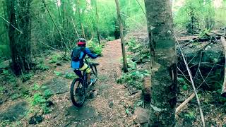
trail: Saint George
4:07 |
405 |
Jul 17, 2020 , Vientiane
Activity Type Stats
| activitytype | trails | distance | descent | descent distance | total vertical | rating | global rank | state rank | photos | reports | routes | ridelogs |
|---|---|---|---|---|---|---|---|---|---|---|---|---|
| Mountain Bike | 9 | 18 miles | 3,645 ft | 9 miles | 3,120 ft | #115 | 1 | 6 | 3,905 | |||
| E-Bike | 8 | 18 miles | 3,612 ft | 9 miles | 3,120 ft | #95 | 6 | 215 | ||||
| Hike | 9 | 18 miles | 3,645 ft | 9 miles | 3,120 ft | #103 | 6 | 1,356 | ||||
| Trail Running | 9 | 18 miles | 3,645 ft | 9 miles | 3,120 ft | #103 | 6 | 20 | ||||
| Dirtbike/Moto | 5 | 12 miles | 1,503 ft | 4 miles | 1,975 ft | #67 | 5 | 27 | ||||
| Observed Trials | 3 | 7 miles | 1,657 ft | 4 miles | 3,041 ft | #50 | 1 | 5 | 4 | |||
| ATV/ORV/OHV | 1 | 5 miles | 56 ft | 2,487 ft | 1,831 ft | #59 |
Activities
Trails
Points of Interest
- By stifford
 & contributors
 - Admins: apply
- #32930 - 4,141 views
- laos activity log | embed map of Laos mountain bike trails |
Downloading of trail gps tracks in kml & gpx formats is enabled for Laos.
You must login to download files.