close
-
Layers w
- Weather Layers
- Pro
- Pro
- Pro
- Pro
- Pro
- Pro
- More Layers
- Pro
- Pro
- Pro
- Pro
-
Upgrade to

3D
Trail Conditions
- Unknown
- Snow Groomed
- Snow Packed
- Snow Covered
- Snow Cover Partial
- Freeze/thaw Cycle
- Icy
- Prevalent Mud
- Wet
- Variable
- Ideal
- Dry
- Very Dry
Trail Flow (Ridden Direction)
Trailforks scans users ridelogs to determine the most popular direction each trail is ridden. A good flowing trail network will have most trails flowing in a single direction according to their intension.
The colour categories are based on what percentage of riders are riding a trail in its intended direction.
The colour categories are based on what percentage of riders are riding a trail in its intended direction.
- > 96%
- > 90%
- > 80%
- > 70%
- > 50%
- < 50%
- bi-directional trail
- no data
Trail Last Ridden
Trailforks scans ridelogs to determine the last time a trail was ridden.
- < 2 days
- < 1 week
- < 2 weeks
- < 1 month
- < 6 months
- > 6 months
Trail Ridden Direction
The intended direction a trail should be ridden.
- Downhill Only
- Downhill Primary
- Both Directions
- Uphill Primary
- Uphill Only
- One Direction
Contribute Details
Colors indicate trail is missing specified detail.
- Description
- Photos
- Description & Photos
- Videos
Trail Popularity ?
Trailforks scans ridelogs to determine which trails are ridden the most in the last 9 months.
Trails are compared with nearby trails in the same city region with a possible 25 colour shades.
Think of this as a heatmap, more rides = more kinetic energy = warmer colors.
- most popular
- popular
- less popular
- not popular
ATV/ORV/OHV Filter
Max Vehicle Width
inches
US Cell Coverage
Legend

Radar Time
Activity Recordings
Trailforks uses anonymized public activity data.
?
Activity Recordings
Trailforks uses anonymized public activity data.
?
Personal Heatmap
▶
Activity Types
all
/
none
▶
Options
2
Date range
month
–
Winter Trails
Warning
A routing network for winter maps does not exist. Selecting trails using the winter trails layer has been disabled.
Missing Trails
Most Popular
Least Popular
Trails are colored based on popularity. The more popular a trail is, the more red. Less popular trails trend towards green.
Jump Magnitude Heatmap
Heatmap of where riders jump on trails. Zoom in to see individual jumps, click circles to view jump details.
BC Backroad Status
![map legend]()
Service Road Atlas is a free to use, community-driven service for viewing and creating reports on the numerous back-country service roads around B.C. and Alberta.

Slope Aspect
Direction the slope faces
Trails Deemphasized
Trails are shown in grey.
Only show trails with no bike usage.
Suggested Layers
Based on selected activity type
Save the current map location and zoom level as your default home location whenever this page is loaded.
SavePopular Trail Networks
view all areas »
No description for Las Vegas has been added yet!
Login or register to submit one.
Activities Click to view
- Mountain Bike
550 trails
- E-Bike
209 trails
- Gravel Bike
18 trails
- Adaptive Bike
1 trails
- Winter Fat Bike
0 trails
- Horse
49 trails
- Hike
705 trails
- Trail Running
696 trails
- Dirtbike/Moto
17 trails
- ATV/ORV/OHV
17 trails
- Snowmobile
0 trails
- Snowshoe
0 trails
- Downhill Ski
27 trails
- Backcountry Ski
0 trails
- Nordic Ski
1 trails
Region Details
- 68
- 20
- 110
- 206
- 88
- 13
- 2
Region Status
Caution as of 2 daysStats
- Avg Trail Rating
- Trails (view details)
- 712
- Trails Mountain Bike
- 551
- Trails E-Bike
- 209
- Trails Gravel Bike
- 18
- Trails Adaptive Bike
- 1
- Trails Horse
- 49
- Trails Hike
- 705
- Trails Trail Running
- 696
- Trails Dirtbike/Moto
- 17
- Trails Observed Trials
- 2
- Trails ATV/ORV/OHV
- 17
- Trails Downhill Ski
- 27
- Trails Nordic Ski
- 1
- Total Distance
- 890 miles
- Total Descent
- 146,754 ft
- Total Vertical
- 14,710 ft
- Highest Trailhead
- 16,145 ft
- Reports
- 7,638
- Photos
- 2,621
- Ridden Counter
- 171,162
Articles
Traveling on a Budget? These 10 U.S. National Parks Are the Most Affordable to Visit.
Jun 16, 2024 from outsideonline.com
Our parks expert has put together long weekend trips for as little as $204, with details on free entrance fees and campsites, and active...

ROKiT Made to Open 'Largest e-Bike Manufacturing Facility' in the United States
Oct 23, 2020 from pinkbike.com
The facility will apparently produce 300,000 units in its first year with plans to increase that to 900,000 in the future.
Sub Regions
-
Brian's Best
-
Calico Basin Area
- 7
- 5
- 3
-
Cottonwood Valley
- 23
- 23
- 12
-
Craig Ranch Regional Park
- 7
-
Da Burbs
- 3
- 22
- 12
- 3
-
Eastside
- 1
- 6
- 5
-
El Paramo
- 2
- 7
-
Enterprise
- 1
-
Exploration Park
- 2
- 2
- 2
- 1
- 1
-
Floyd Lamb Park At Tule Springs
- 11
- 8
- 4
-
Lee Canyon Resort
- 1
- 2
- 1
-
Mt. Charleston
- 4
- 18
- 7
-
Pueblo Park
- 1
-
Rainbow Gardens
- 1
-
Red Rock - Bear’s Best
- 1
- 13
- 52
- 10
-
Red Rock - Cowboy Trails
- 2
- 7
- 13
- 4
-
Red Rock Canyon National Conservation Area
- 1
- 1
-
Southwest Ridge
- 4
- 7
- 3
- 2
-
Sun City
- 9
- 1
- 1
-
Sunset Park
- 3
-
Tule Springs Fossil Beds National Monument
- 1
-
Twilight Zone
- 1
- 13
-
Union Trails
- 13
- 24
- 19
- 2
Popular Las Vegas Mountain Biking Trails
• 100 ★ 4.1 • 3 miles • 654 ft • 2,097 •
Highly rated popular green difficulty singletrack. This mountain bike primary trail. On average it takes 29 minutes to complete this trail.
• 100 ★ 4.4 • 1 mile • 15 ft • 2,043 •
Highly rated popular green difficulty singletrack. This mountain bike primary trail can be used both directions and has a easy overall physical rating with a 15 ft green climb. Trail visibility is always easy to follow. On average it takes 9 minutes to complete this trail.
• 100 ★ 3.6 • 1,463 ft • 0 ft • 1,945 •
Easy desert singletrack to connect the 2 trail systems. Some washed gravel sections, but pretty easy.
• 100 ★ 4.8 • 4,961 ft • 152 ft • 1,913 •
This is one of the most well known trails in the Cottonwood Valley riding area. Be on the lookout for the family of wild ducks that have taken up residence in one of the native Joshua Trees!
• 100 ★ 3.3 • 1,873 ft • 0 ft • 1,861 •
Popular blue difficulty singletrack. This mountain bike primary trail can be used uphill primary and has a hard overall physical rating with a 0 ft black diamond climb. On average it takes 3 minutes to complete this trail.
• 100 ★ 4.5 • 4 miles • 363 ft • 1,669 •
Highly rated popular green difficulty singletrack. This mountain bike primary trail can be used both directions and has a easy overall physical rating with a 363 ft green climb. On average it takes 8 minutes to complete this trail.
• 100 ★ 4.6 • 1 mile • 0 ft • 1,644 •
Highly rated popular green difficulty singletrack. This mountain bike primary trail can be used both directions and has a easy overall physical rating with a 0 ft green climb. On average it takes 6 minutes to complete this trail.
• 100 ★ 4.1 • 7 miles • 511 ft • 1,619 •
This is the main access trail to the rest of Blue Diamond/Cottonwood. It's a pretty decent climb and a fun and challenging downhill when you're headed back in. Don't forget to look up and look around.. you can get some great views of...
Las Vegas Mountain Bike Routes
★ 3.9 • 10 miles • 639 ft • 6 • Loop •
The Blue Diamond Loop is my go-to loop at Cottonwood. It can be ridden in well under an hour, is nearly 10...
★ 4.5 • 7 miles • 683 ft • 13 •
Visitor created, going to try it out tomorrow if the rain doesn't get crazy. 4/10/16- didn't actually get...
★ 3.7 • 14 miles • 1,573 ft • 5 •
Great loop. Satan's is a climb which is a big grunt but leads to Vegas View and down The Smile and Badger...
★ 4.0 • 13 miles • 1,688 ft • 2 •
Ebb n' Flow is one of Vegas's newest trails and it should not be missed by experienced riders! The climb...
★ 4.5 • 13 miles • 391 ft • 4 •
Smooth and flowing to start, right of the bat fast!
Photos of Las Vegas Mountain Bike
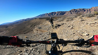
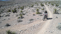
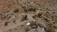
Videos of Las Vegas Mountain Bike
trail: GnarWhale
0:51 |
12 |
May 11, 2026
trail: Frenchman's Freeride
0:29 |
36 |
Sep 3, 2025
trail: Sneaky Pete
0:32 |
|
Mar 23, 2025
trail: EBB'nFlow
6:53 |
46 |
Feb 18, 2025
trail: Dragon's Drop
0:36 |
175 |
Mar 10, 2022

trail: Bears Best
0:11 |
272 |
Feb 3, 2022

trail: Jenny from the Block
2:02 |
84 |
Nov 20, 2021
trail: Wicked Garden
4:47 |
109 |
Aug 7, 2021
Current Trail Warnings
| status | trail | date | condition | user | info |
|---|---|---|---|---|---|
| Outer Limit | Jun 19, 2026 @ 5:51pm (America/Los_Angeles) 2 days | Very Dry | TAmador | Do not ride this trail almost walked... |
Recent Trail Reports
Activity Feed
| username | action | type | title | date |
|---|---|---|---|---|
| metalheadmilo17 | difficultyvote | trail | activity #97427902 | Jun 20, 2026 @ 1:24pm 1 day |
| Dthorn0822 | add | video | activity #97415482 | Jun 20, 2026 @ 11:14am 1 day |
| y4NpsS | wishlist | route | activity #97404535 | Jun 20, 2026 @ 9:28am 1 day |
| TAmador | add | report | activity #97357108 and 1 more | Jun 19, 2026 @ 5:48pm 2 days |
| bigcows13 | wishlist | trail | activity #97347966 | Jun 19, 2026 @ 3:16pm 2 days |
Recent Comments
| username | type | title | comment | date |
|---|---|---|---|---|
| trail | We shouldn’t skew the Blue Diamond area... | Jun 18, 2026 @ 3:40pm Jun 18, 2026 | ||
| trail | This is black - take it to get to Flowered... | Jun 17, 2026 @ 7:59am Jun 17, 2026 | ||
| trail | This trail is phenomenal. Absolutely worth the... | Jun 14, 2026 @ 11:28pm Jun 14, 2026 | ||
| trail | This might just be the best trail in bears... | Jun 14, 2026 @ 11:26pm Jun 14, 2026 | ||
| trail | This is a pretty fun trail and the wash... | Jun 14, 2026 @ 11:24pm Jun 14, 2026 |
Local Badges
-

Completionist0 awarded -
Completionist0 awarded -
Completionist40 awarded -
Completionist9 awarded -
Completionist3 awarded -
Completionist1 awarded
Bike & Skill Parks
| name | type | city | rating |
|---|---|---|---|
| Lee Canyon Resort | bike park | Las Vegas | |
| Sandy Valley MX | skill park | Las Vegas |
Activity Type Stats
| activitytype | trails | distance | descent | descent distance | total vertical | rating | global rank | state rank | photos | reports | routes | ridelogs |
|---|---|---|---|---|---|---|---|---|---|---|---|---|
| Mountain Bike | 550 | 661 miles | 99,432 ft | 323 miles | 14,711 ft | #36 | #12 | 2,335 | 7,613 | 94 | 197,420 | |
| E-Bike | 209 | 237 miles | 31,168 ft | 109 miles | 6,299 ft | #164 | #660 | 12 | 6,765 | 11 | 16,505 | |
| Gravel Bike | 18 | 20 miles | 2,238 ft | 8 miles | 6,860 ft | #75 | #782 | 5 | 100 | 7 | 335 | |
| Adaptive Bike | 1 | #36 | #661 | 4 | 5 | 10 | ||||||
| Horse | 49 | 77 miles | 11,762 ft | 42 miles | 7,041 ft | #195 | #414 | 1,010 | 19 | |||
| Hike | 705 | 858 miles | 135,328 ft | 404 miles | 14,711 ft | #17 | #24 | 267 | 7,590 | 29 | 18,043 | |
| Trail Running | 696 | 849 miles | 135,712 ft | 401 miles | 14,711 ft | #20 | #19 | 22 | 7,579 | 30 | 9,793 | |
| Dirtbike/Moto | 17 | 48 miles | 6,493 ft | 28 miles | 6,014 ft | #143 | #88 | 6 | 1,004 | 2 | 118 | |
| Observed Trials | 2 | 4 miles | 531 ft | 1 mile | 863 ft | 11 | 1 | 27 | ||||
| ATV/ORV/OHV | 17 | 55 miles | 8,379 ft | 32 miles | 4,829 ft | #59 | #39 | 1,011 | 90 | |||
| Downhill Ski | 27 | 6 miles | 4,639 ft | 5 miles | 755 ft | #266 | #108 | 1 | 508 | |||
| Nordic Ski | 1 | 2 miles | 427 ft | 2 miles | 407 ft | #293 | #79 | 41 | 94 |
Frequently Asked Questions About Las Vegas
▼
What are the best places to ride in Las Vegas?
Las Vegas has 25 areas to explore for mountain biking. The top rated areas are:
▼
What are the highest rated mountain biking trails in Las Vegas?
The highest rated mountain biking trails in Las Vegas are:
- Bipolar (4.7/5)
- 3 Mile Smile (4.6/5)
- Bone Shaker (4.6/5)
- Mustang Loop (4.5/5)
- Viagra (4.5/5)
▼
What is the best time of the year to ride in Las Vegas?
Based on ride log data, the most popular months to ride in Las Vegas are:
- May (2,058 activities)
- April (1,950 activities)
- November (1,873 activities)
▼
Where can I park to ride in Las Vegas?
There are 77 parking locations listed in Las Vegas. The most popular parking spots are:
- Late Night Lot Parking
- Blue Diamond Parking at McGhies Bike Outpost
- Bears Best North
- Red Valley Trailhead
- Mesa Park
Activities
Trails
Points of Interest
- By brenthillier
 NSMBA TRAILFORKS & contributors
 - Admins: Las Vegas, SNMBA, JonnieDangerously, BLM NV GBNM
- #3964 - 186,431 views
- las vegas activity log | embed map of Las Vegas mountain bike trails | las vegas mountain biking points of interest polygons
Downloading of trail gps tracks in kml & gpx formats is enabled for Las Vegas.
You must login to download files.