close
-
Layers w
- Weather Layers
- Pro
- Pro
- Pro
- Pro
- Pro
- Pro
- More Layers
- Pro
- Pro
- Pro
- Pro
-
Upgrade to

3D
Trail Conditions
- Unknown
- Snow Groomed
- Snow Packed
- Snow Covered
- Snow Cover Partial
- Freeze/thaw Cycle
- Icy
- Prevalent Mud
- Wet
- Variable
- Ideal
- Dry
- Very Dry
Trail Flow (Ridden Direction)
Trailforks scans users ridelogs to determine the most popular direction each trail is ridden. A good flowing trail network will have most trails flowing in a single direction according to their intension.
The colour categories are based on what percentage of riders are riding a trail in its intended direction.
The colour categories are based on what percentage of riders are riding a trail in its intended direction.
- > 96%
- > 90%
- > 80%
- > 70%
- > 50%
- < 50%
- bi-directional trail
- no data
Trail Last Ridden
Trailforks scans ridelogs to determine the last time a trail was ridden.
- < 2 days
- < 1 week
- < 2 weeks
- < 1 month
- < 6 months
- > 6 months
Trail Ridden Direction
The intended direction a trail should be ridden.
- Downhill Only
- Downhill Primary
- Both Directions
- Uphill Primary
- Uphill Only
- One Direction
Contribute Details
Colors indicate trail is missing specified detail.
- Description
- Photos
- Description & Photos
- Videos
Trail Popularity ?
Trailforks scans ridelogs to determine which trails are ridden the most in the last 9 months.
Trails are compared with nearby trails in the same city region with a possible 25 colour shades.
Think of this as a heatmap, more rides = more kinetic energy = warmer colors.
- most popular
- popular
- less popular
- not popular
ATV/ORV/OHV Filter
Max Vehicle Width
inches
US Cell Coverage
Legend

Radar Time
Activity Recordings
Trailforks uses anonymized public activity data.
?
Activity Recordings
Trailforks uses anonymized public activity data.
?
Personal Heatmap
▶
Activity Types
all
/
none
▶
Options
2
Date range
month
–
Winter Trails
Warning
A routing network for winter maps does not exist. Selecting trails using the winter trails layer has been disabled.
Missing Trails
Most Popular
Least Popular
Trails are colored based on popularity. The more popular a trail is, the more red. Less popular trails trend towards green.
Jump Magnitude Heatmap
Heatmap of where riders jump on trails. Zoom in to see individual jumps, click circles to view jump details.
BC Backroad Status
![map legend]()
Service Road Atlas is a free to use, community-driven service for viewing and creating reports on the numerous back-country service roads around B.C. and Alberta.

Slope Aspect
Direction the slope faces
Trails Deemphasized
Trails are shown in grey.
Only show trails with no bike usage.
Suggested Layers
Based on selected activity type
Save the current map location and zoom level as your default home location whenever this page is loaded.
SavePopular Trail Networks
view all areas »
No description for Laurentides has been added yet!
Login or register to submit one.
Primary Trail Type: Cross-Country
Land Status: Managed by Local Riding Association
Region Details
- 26
- 36
- 204
- 368
- 143
- 41
- 2
Local Trail Association
Stats
- Avg Trail Rating
- Trails (view details)
- 1,389
- Trails Mountain Bike
- 864
- Trails E-Bike
- 511
- Trails Gravel Bike
- 5
- Trails Adaptive Bike
- 1
- Trails Winter Fat Bike
- 6
- Trails Horse
- 2
- Trails Hike
- 921
- Trails Trail Running
- 903
- Trails Dirtbike/Moto
- 2
- Trails ATV/ORV/OHV
- 4
- Trails Snowmobile
- 2
- Trails Snowshoe
- 342
- Trails Downhill Ski
- 58
- Trails Backcountry Ski
- 109
- Trails Nordic Ski
- 370
- Total Distance
- 1,385 miles
- Total Descent
- 197,746 ft
- Total Vertical
- 3,025 ft
- Highest Trailhead
- 3,031 ft
- Reports
- 8,501
- Photos
- 1,892
- Ridden Counter
- 218,730
Articles
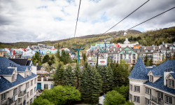
Destination Showcase: Mont-Tremblant, Quebec
Jul 4, 2019 from pinkbike.com
Nestled deep in the Laurentian Mountains in Eastern Canada lies the resort town of Mont-Tremblant.

Event Report: Canada Cup Round 1 - Tremblant, Quebec
Jun 17, 2019 from pinkbike.com
The first Canada Cup of the year was held in Tremblant trail for the 25th year in a row.
Sub Regions
- Bellefeuille (21)
- Blainville (20)
- Ferme-Neuve (18)
- la conception (0)
- Labelle (1)
- Lac-Des-Iles (8)
- Lachute (0)
- Mirabel (25)
- Mont-Laurier (1)
- Morin Heights (12)
- Morin-Heights (26)
- Sentiers Parc Basler (16)
- Sommet Morin Heights (14)
- Municipalité de Mont-Blanc (23)
- Ski Mont-Blanc (23)
- Notre-Dame-du-Laus (0)
- Oka (113)
- Piedmont (14)
- Pointe-Calumet (4)
- Prevost (23)
- Parc de la Coulée (22)
- Rosemere (4)
- Saint-André-d'Argenteuil (2)
- Saint-Hippolyte (26)
- Sainte-Adèle (148)
- Sainte-Agathe-des-monts (0)
- Sainte-Anne-Des-Lacs (14)
- Sainte-Marthe-sur-le-Lac (1)
- St-Adolphe-d'Howard (44)
- Mont-Avalanche (41)
- St-Jérôme (166)
- St-Sauveur (19)
- Ste-Anne-des-Lacs (18)
- Val-David (39)
- Val-Morin (54)
- MTB Belle Neige (54)
- Ville de Mont-Tremblant (117)
- Wentworth-Nord (19)
- Parc national du Mont-Tremblant (7)
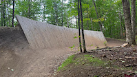
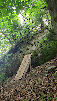
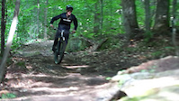
Popular Laurentides Mountain Biking Trails
Pom-Track Permanently Closed
• 100 ★ 2.8 • 492 ft • 5 ft • 1,848 •
Popular blue difficulty closed singletrack. This mountain bike primary trail. It features pump track. On average it takes 1 minutes to complete this trail.
• 100 ★ 4.2 • 4,242 ft • 99 ft • 1,703 •
Highly rated popular green difficulty singletrack. This mountain bike primary trail can be used downhill primary and has a easy overall physical rating with a 99 ft blue climb. On average it takes 6 minutes to complete this trail.
• 100 ★ 2.7 • 1,396 ft • 10 ft • 1,514 •
Nice side project to the gravel road, drop in from the east end, zig zag up and down between the trees then cross the gravel and head uphill up the slope.
• 100 ★ 3.4 • 315 ft • 0 ft • 1,410 •
Popular green difficulty doubletrack. This multi-use trail can be used both directions. On average it takes minutes to complete this trail.
• 100 ★ 3.4 • 449 ft • 0 ft • 1,382 •
Popular blue difficulty singletrack. This mountain bike primary trail can be used both directions. On average it takes 1 minutes to complete this trail.
• 100 ★ 4.2 • 1,686 ft • 0 ft • 1,373 •
New upper section for 2017! Some steep flowy berms mixed in with jumps, tabletops and drops, of course it keeps the very steep ending!
• 95 ★ 4.3 • 2,198 ft • 4 ft • 1,342 •
Fast, very fast but oh soooo smooth. There's an optional Jump on the right side before reaching but it also has a wide pass to its left, the new lower section has some pretty steep sections.
Laurentides Mountain Bike Routes
★ 5.0 • 7 miles • 1,155 ft • 1 • Loop •
Le Parc du Mont , propriété de la Ville de Sainte-Adèle, est un véritable paradis de plein air...
★ 5.0 • 4 miles • 448 ft • 5 • Loop •
This is a route for a single descent taking to long way up and back down.
2 miles • 287 ft • 3 •
Le trajet parfait pour jaser en randonnée. Un sentier large et agréable, permettant d'être côte à...
4,216 ft • 58 ft • 5 •
Un parcours idéal pour les familles avec des enfants, une courte randonnée parcourant des sentiers...
★ 5.0 • 15 miles • 518 ft • 1 • Out & Back •
Quick ride our and back from 64e ave Pointe-Calumet to the Oka Ferry
Photos of Laurentides Mountain Bike
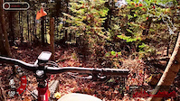
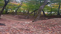
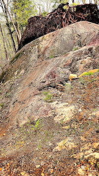
Videos of Laurentides Mountain Bike
trail: Presto
0:04 |
27 |
Sep 25, 2025
trail: La Golée (Pro-Line)
0:04 |
28 |
Jul 16, 2025
trail: Serpentine bas
0:24 |
162 |
Jul 11, 2025
trail: Basler
0:15 |
|
Oct 29, 2024
trail: Résurrection
2:19 |
43 |
Apr 20, 2024
trail: Hydrogène
0:11 |
97 |
Apr 2, 2024
trail: MSG
0:08 |
107 |
May 13, 2023
trail: Simple Pleasures
0:12 |
77 |
Mar 19, 2023
Current Trail Warnings
| status | trail | date | condition | user | info |
|---|---|---|---|---|---|
| King Créole Sentiers Mont-Tremblant (réseau municipal) | Jun 4, 2026 @ 12:55pm (America/Toronto) Jun 4, 2026 | Dry | g-man74 | Travaux dans la upper section! lower... | |
| Along the 640 Pointe-Calumet | Jun 3, 2026 @ 2:27pm (America/Toronto) Jun 3, 2026 | Variable | JohnPare1234 | Overgrown vegetation | |
| Sentier De La Sauvagine Parc national d'Oka | May 26, 2026 @ 4:46pm (America/Toronto) May 26, 2026 | Prevalent Mud | JohnPare1234 |
Recent Trail Reports
Activity Feed
| username | action | type | title | date |
|---|---|---|---|---|
| zenetik | add | route | activity #97559771 and 1 more | Jun 22, 2026 @ 7:16am 5 hours |
| MarcAndr2qAoAQ | wishlist | region | activity #97538997 | Jun 21, 2026 @ 7:38pm 17 hours |
| MarcAndr2qAoAQ | wishlist | region | activity #97538895 | Jun 21, 2026 @ 7:35pm 17 hours |
| MarcAndr2qAoAQ | wishlist | region | activity #97538888 | Jun 21, 2026 @ 7:35pm 17 hours |
| MarcAndr2qAoAQ | wishlist | region | activity #97538862 | Jun 21, 2026 @ 7:34pm 17 hours |
Recent Comments
| username | type | title | comment | date |
|---|---|---|---|---|
| trail | Si tu veux convaincre quelqu’un ou toi-même... | Jun 15, 2026 @ 7:03am Jun 15, 2026 | ||
| trail | L’accès par le chemin Séguin est fermé.... | Jun 10, 2026 @ 9:44am Jun 10, 2026 | ||
| trail | Trial is in great shape in 2026. Work has been... | Jun 8, 2026 @ 3:29am Jun 8, 2026 | ||
| trail | Très belle trail de descente, gros berms.... | Jun 4, 2026 @ 1:35pm Jun 4, 2026 | ||
| trail | 2026 update. Still overgrown and no longer the... | Jun 4, 2026 @ 3:15am Jun 4, 2026 |
Local Badges
-

10 Black Trails340 awarded -

Top 10 Trails0 awarded -

Completionist0 awarded -

10 Blue Trails21 awarded -

10 Green Trails1 awarded -

Epic Mountain Bike Climb 2k0 awarded
Bike & Skill Parks
| name | type | city | rating |
|---|---|---|---|
| Parc vélo Sommet Saint-Sauveur | bike park | Piedmont | |
| Ski Mont-Blanc | bike park | Municipalité de Mont-Blanc | |
| Pumptrack & modules d'habileté | skill park | Mirabel | |
| BMX Boisbriand | skill park | Boisbriand | |
| BMX Saint-Eustache | skill park | St-Eustache |
Upcoming Local Events
Activity Type Stats
| activitytype | trails | distance | descent | descent distance | total vertical | rating | global rank | state rank | photos | reports | routes | ridelogs |
|---|---|---|---|---|---|---|---|---|---|---|---|---|
| Mountain Bike | 864 | 676 miles | 99,793 ft | 265 miles | 2,028 ft | 1,766 | 8,382 | 50 | 143,760 | |||
| E-Bike | 511 | 409 miles | 41,581 ft | 157 miles | 1,909 ft | 30 | 7,435 | 14 | 4,622 | |||
| Gravel Bike | 5 | 5 | 53 | 7 | 1,212 | |||||||
| Adaptive Bike | 1 | 1 | 5 | 12 | ||||||||
| Winter Fat Bike | 6 | 1 | 53 | 3 | 568 | |||||||
| Horse | 2 | 6 miles | 92 ft | 3 miles | 56 ft | 1,780 | 29 | |||||
| Hike | 921 | 867 miles | 117,234 ft | 322 miles | 3,025 ft | 47 | 7,576 | 22 | 9,298 | |||
| Trail Running | 903 | 841 miles | 115,459 ft | 314 miles | 3,025 ft | 30 | 7,609 | 27 | 7,186 | |||
| Dirtbike/Moto | 2 | 5 miles | 72 ft | 2,093 ft | 66 ft | 1,785 | 80 | |||||
| ATV/ORV/OHV | 4 | 6 miles | 177 ft | 1 mile | 253 ft | 1,786 | 136 | |||||
| Snowmobile | 2 | 3 miles | 72 ft | 2,093 ft | 66 ft | 2 | 87 | 91 | ||||
| Snowshoe | 342 | 285 miles | 38,812 ft | 111 miles | 2,940 ft | 2 | 867 | 10 | 1,657 | |||
| Downhill Ski | 58 | 17 miles | 14,068 ft | 16 miles | 833 ft | 577 | 13,487 | |||||
| Backcountry Ski | 109 | 144 miles | 16,194 ft | 54 miles | 2,746 ft | 2 | 224 | 3 | 5,403 | |||
| Nordic Ski | 370 | 553 miles | 51,982 ft | 203 miles | 2,789 ft | 686 | 1 | 10,163 |
Activities
- Laurentides Mountain Biking Trails
- Laurentides E-Biking Trails
- Laurentides Gravel Biking Trails
- Laurentides Winter Fat Biking Trails
- Laurentides Hiking Trails
- Laurentides Trail Running Trails
- Laurentides Snowshoeing Trails
- Laurentides Skiing Trails
- Laurentides Backcountry Skiing Trails
- Laurentides Nordic Skiing Trails
Trails
Points of Interest
- Abri Belzebuth Cabin
- Point de vue Viewpoint
- Banc d'ourson Sight
- La Corniche Viewpoint
- La Roche Viewpoint
- Mont Saint Bernard Summit
- Les Grandes-Vallées Viewpoint
- Paroi de l'Aube Viewpoint
- Abri de la Paroi de l'Aube Cabin
- Sommet du Garde Feu Summit
- Pic White (2,864 ft)
- The Edge (2,746 ft)
- Mont Sir-Wilfrid (2,507 ft)
- By MecaNick & contributors
- Admins: VQ, bigjay, StephaneMarceau, Canadmos
- #5181 - 22,857 views
- laurentides activity log | embed map of Laurentides mountain bike trails | laurentides mountain biking points of interest polygons
Downloading of trail gps tracks in kml & gpx formats is enabled for Laurentides.
You must login to download files.