close
-
Layers w
- Weather Layers
- Pro
- Pro
- Pro
- Pro
- Pro
- Pro
- More Layers
- Pro
- Pro
- Pro
- Pro
-
Upgrade to

3D
Trail Conditions
- Unknown
- Snow Groomed
- Snow Packed
- Snow Covered
- Snow Cover Partial
- Freeze/thaw Cycle
- Icy
- Prevalent Mud
- Wet
- Variable
- Ideal
- Dry
- Very Dry
Trail Flow (Ridden Direction)
Trailforks scans users ridelogs to determine the most popular direction each trail is ridden. A good flowing trail network will have most trails flowing in a single direction according to their intension.
The colour categories are based on what percentage of riders are riding a trail in its intended direction.
The colour categories are based on what percentage of riders are riding a trail in its intended direction.
- > 96%
- > 90%
- > 80%
- > 70%
- > 50%
- < 50%
- bi-directional trail
- no data
Trail Last Ridden
Trailforks scans ridelogs to determine the last time a trail was ridden.
- < 2 days
- < 1 week
- < 2 weeks
- < 1 month
- < 6 months
- > 6 months
Trail Ridden Direction
The intended direction a trail should be ridden.
- Downhill Only
- Downhill Primary
- Both Directions
- Uphill Primary
- Uphill Only
- One Direction
Contribute Details
Colors indicate trail is missing specified detail.
- Description
- Photos
- Description & Photos
- Videos
Trail Popularity ?
Trailforks scans ridelogs to determine which trails are ridden the most in the last 9 months.
Trails are compared with nearby trails in the same city region with a possible 25 colour shades.
Think of this as a heatmap, more rides = more kinetic energy = warmer colors.
- most popular
- popular
- less popular
- not popular
ATV/ORV/OHV Filter
Max Vehicle Width
inches
US Cell Coverage
Legend

Radar Time
Activity Recordings
Trailforks uses anonymized public activity data.
?
Activity Recordings
Trailforks uses anonymized public activity data.
?
Personal Heatmap
▶
Activity Types
all
/
none
▶
Options
2
Date range
month
–
Winter Trails
Warning
A routing network for winter maps does not exist. Selecting trails using the winter trails layer has been disabled.
Missing Trails
Most Popular
Least Popular
Trails are colored based on popularity. The more popular a trail is, the more red. Less popular trails trend towards green.
Jump Magnitude Heatmap
Heatmap of where riders jump on trails. Zoom in to see individual jumps, click circles to view jump details.
BC Backroad Status
![map legend]()
Service Road Atlas is a free to use, community-driven service for viewing and creating reports on the numerous back-country service roads around B.C. and Alberta.

Slope Aspect
Direction the slope faces
Trails Deemphasized
Trails are shown in grey.
Only show trails with no bike usage.
Suggested Layers
Based on selected activity type
Save the current map location and zoom level as your default home location whenever this page is loaded.
Save
No description for Lehigh County has been added yet!
Login or register to submit one.
Links
Activities Click to view
- Mountain Bike
105 trails
- E-Bike
44 trails
- Gravel Bike
8 trails
- Hike
95 trails
- Trail Running
96 trails
- Downhill Ski
24 trails
Stats
- Avg Trail Rating
- Trails (view details)
- 129
- Trails Mountain Bike
- 105
- Trails E-Bike
- 44
- Trails Gravel Bike
- 8
- Trails Adaptive Bike
- 7
- Trails Winter Fat Bike
- 13
- Trails Horse
- 2
- Trails Hike
- 95
- Trails Trail Running
- 96
- Trails ATV/ORV/OHV
- 1
- Trails Snowshoe
- 3
- Trails Downhill Ski
- 24
- Trails Backcountry Ski
- 1
- Trails Nordic Ski
- 2
- Total Distance
- 99 miles
- Total Descent
- 14,617 ft
- Total Vertical
- 1,315 ft
- Highest Trailhead
- 1,568 ft
- Reports
- 1,304
- Photos
- 256
- Ridden Counter
- 17,299
Sub Regions
- Alburtis (2)
- Allentown (27)
- Jordan Creek (5)
- Jordan Parkway (1)
- Lehigh Parkway (13)
- Emmaus (43)
- Hellertown (1)
- Macungie (9)
- Salisbury (28)
- Saltington (1)
- Schnecksville (31)
Popular Lehigh County Mountain Biking Trails
• 95 ★ 4.6 • 4,186 ft • 57 ft • 1,695 •
After doing the entirety of , turn left up and after a bit, you'll be at the entrance of , similar to , including tabletops, jumps, and berms.
• 100 ★ 4.5 • 3,691 ft • 18 ft • 1,670 •
Starting from , is a fast and flow-y trail with some jumps thrown in.
• 90 ★ 4.0 • 1,588 ft • 51 ft • 1,510 •
Highly rated popular green difficulty singletrack. This mountain bike primary trail can be used both directions and has a easy overall physical rating with a 51 ft green climb. It features roller coaster. Trail visibility is always easy to follow. On average it takes 2 minutes to complete this trail.
• 80 ★ 4.4 • 4,977 ft • 0 ft • 1,463 •
This trail is one way. This trail is a nice nugget that zig-zags on the hill on the opposite side from the Half Pipe section. There are plenty of mixed size lumps to catch a little air on. The ledge gets a little narrow at times. There...
• 65 ★ 4.1 • 3,793 ft • 58 ft • 1,206 •
Highly rated moderately popular green difficulty singletrack. This mountain bike primary trail can be used both directions and has a easy overall physical rating with a 58 ft green climb. Trail visibility is always easy to follow. On average it takes 7 minutes to complete this trail.
• 60 ★ 4.7 • 2,815 ft • 33 ft • 1,081 •
This is a fun jump trail that includes assorted berms, tables, rollers.
• 85 ★ 3.9 • 1,345 ft • 14 ft • 994 •
Connector cuts across the top of the hill and bypasses Half Pipe to get you to . If you have ridden Half Pipe and already you can take Connector in the opposite direction and ride Half Pipe again.
• 75 ★ 4.5 • 2 miles • 149 ft • 894 •
Highly rated popular black diamond difficulty singletrack. This mountain bike primary trail and has a hard overall physical rating with a 149 ft blue climb. It features berm, drop, jump, gap jump, pump track, roller coaster and wallride. Trail visibility is always easy to follow. On average it takes 14 minutes to complete this trail.
Lehigh County Mountain Bike Routes
8 miles • 866 ft • 5 • Loop •
This is the typical direction ridden from the North Range parking lot. This route takes you to the top of...
★ 5.0 • 7 miles • 672 ft • 17 •
sweet little lap of trexler. start with broken arrow after a climb to the summit. then hit half pipe and...
★ 3.5 • 6 miles • 880 ft • 14 • Out & Back •
Nice little ride on South Mountain. Starts at alpine parking heads out to the log trail by way of yellow...
★ 5.0 • 2 miles • 256 ft • 11 •
Halfpipe loop up and down we go. when we stop no one knows.
7 miles • 728 ft • 17 •
Brian to Broken Arrow to Half pipe loop is pretty sweet
5 miles • 543 ft • 4 • Loop •
This loop takes you from the parking lot through all three Half Pipe tracks and around to get back to the...
Photos of Lehigh County Mountain Bike
Videos of Lehigh County Mountain Bike
trail: Jack O' Diamonds
0:22 |
797 |
Nov 19, 2022
trail: Jack O' Diamonds
0:36 |
467 |
Nov 19, 2022

trail: Jack O' Diamonds
0:10 |
298 |
Nov 19, 2022
trail: Jack O' Diamonds
0:10 |
144 |
Nov 19, 2022
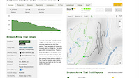
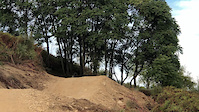
trail: Broken Arrow Trail
5:30 |
85 |
Aug 22, 2021
trail: The Return of Brian's
0:11 |
186 |
Jul 2, 2021
trail: Broken Arrow Trail
0:22 |
493 |
Mar 24, 2021
trail: Half-Pipe 1
0:14 |
293 |
Sep 23, 2018
Recent Trail Reports
Activity Feed
| username | action | type | title | date |
|---|---|---|---|---|
| maddiefaust | wishlist | route | activity #97261075 | Jun 18, 2026 @ 10:22am 17 hours |
| Philliesnine77 | wishlist | region | activity #97251046 | Jun 18, 2026 @ 7:35am 20 hours |
| schecter3090 | wishlist | route | activity #97100584 | Jun 16, 2026 @ 4:55am 3 days |
| Cavmen | wishlist | region | activity #97081559 | Jun 15, 2026 @ 6:56pm Jun 15, 2026 |
| asnowmobiler | add | karma | activity #97004939 | Jun 14, 2026 @ 2:27pm Jun 14, 2026 |
Recent Comments
| username | type | title | comment | date |
|---|---|---|---|---|
| trail | This trail is awesome if you like tech. | Oct 13, 2025 @ 1:33pm Oct 13, 2025 | ||
| trail | This trail is a fun downhill, with a bunch of... | Oct 13, 2025 @ 1:30pm Oct 13, 2025 | ||
| report | G yo@‘bad Lkop no gu s | Oct 12, 2025 @ 3:11pm Oct 12, 2025 | ||
| report | Down tree | Aug 9, 2025 @ 2:29pm Aug 9, 2025 | ||
| trail | Nice flowing downhill. Lots of dead trees... | Jul 29, 2025 @ 1:31pm Jul 29, 2025 |
Local Badges
-

Descent 100k Badge0 awarded -

Descent 10k Badge21 awarded -
Descent 10k Badge13 awarded -
Descent 10k Badge12 awarded -
Descent 100k Badge0 awarded -
Descent 100k Badge0 awarded
Bike & Skill Parks
| name | type | city | rating |
|---|---|---|---|
| Bear Creek Mountain Resort | bike park | Macungie | |
| Camp Olympic Pump Track | skill park | Allentown |
Upcoming Local Events
-
-
Local Mountain Biking Directory
-
The Velo Shop
![The Velo Shop]()
-
Dirtsculpt
![Dirtsculpt]()
-
Saucon Valley Bikes
Bike Shop
-
Bike Line - Allentown
Bike Shop
-
Fitness Central Bike Shop
![Fitness Central Bike Shop]() Bike Shop
Bike Shop
-
Bike Line Of Allentown
Bike Shop
Local Trail Association
-

Local Mountain Biking Directory
-
The Velo Shop
![The Velo Shop]()
-
Dirtsculpt
![Dirtsculpt]()
-
Saucon Valley BikesBike Shop
-
Bike Line - AllentownBike Shop
-
Fitness Central Bike ShopBike Shop
![Fitness Central Bike Shop]()
-
Bike Line Of AllentownBike Shop
Local Trail Association
Activity Type Stats
| activitytype | trails | distance | descent | descent distance | total vertical | rating | global rank | state rank | photos | reports | routes | ridelogs |
|---|---|---|---|---|---|---|---|---|---|---|---|---|
| Mountain Bike | 105 | 92 miles | 11,165 ft | 39 miles | 1,316 ft | #5,656 | 253 | 1,303 | 19 | 38,973 | ||
| E-Bike | 44 | 52 miles | 5,610 ft | 24 miles | 1,312 ft | 1 | 1,205 | 10 | 1,973 | |||
| Gravel Bike | 8 | 11 miles | 1,306 ft | 4 miles | 558 ft | 71 | 1 | 149 | ||||
| Adaptive Bike | 7 | 12 miles | 1,358 ft | 5 miles | 469 ft | 52 | 4 | |||||
| Winter Fat Bike | 13 | 8 miles | 1,240 ft | 3 miles | 810 ft | 121 | 29 | |||||
| Horse | 2 | 3 miles | 82 ft | 1 mile | 564 ft | 196 | 1 | |||||
| Hike | 95 | 85 miles | 10,407 ft | 35 miles | 889 ft | #5,055 | 1 | 1,228 | 1 | 1,238 | ||
| Trail Running | 96 | 86 miles | 10,495 ft | 36 miles | 889 ft | #5,882 | 1,226 | 3 | 999 | |||
| ATV/ORV/OHV | 1 | 850 ft | 79 ft | 194 | 6 | |||||||
| Snowshoe | 3 | 13 miles | 774 ft | 8 miles | 312 ft | 4 | 36 | |||||
| Downhill Ski | 24 | 4 miles | 2,782 ft | 4 miles | 449 ft | 630 | ||||||
| Backcountry Ski | 1 | 4,944 ft | 82 ft | 1,257 ft | 85 ft | 16 | ||||||
| Nordic Ski | 2 | 9 miles | 404 ft | 7 miles | 312 ft | 3 | 93 |
Frequently Asked Questions About Lehigh County
▼
What are the best places to ride in Lehigh County?
Lehigh County has 8 areas to explore for mountain biking. The top rated areas are:
▼
What are the highest rated mountain biking trails in Lehigh County?
The highest rated mountain biking trails in Lehigh County are:
- The Return of Brian's (4.5/5)
- Half-Pipe 2 (4.4/5)
- Half-Pipe 1 (4.4/5)
- Jack O' Diamonds (4.3/5)
- Broken Arrow Trail (4.3/5)
▼
What is the best time of the year to ride in Lehigh County?
Based on ride log data, the most popular months to ride in Lehigh County are:
- July (398 activities)
- October (319 activities)
- September (317 activities)
▼
What is the longest trail in Lehigh County?
The longest trail in Lehigh County is Border Trail (West) at 6.2 miles. View all trails sorted by distance.
Activities
Trails
- By Everett78 & contributors
- Admins: Turntex, PlumbBobM, VMB, VMB
- #35020 - 2,354 views
- lehigh county activity log | embed map of Lehigh County mountain bike trails | lehigh county mountain biking points of interest
Downloading of trail gps tracks in kml & gpx formats is enabled for Lehigh County.
You must login to download files.