close
-
Layers w
- Weather Layers
- Pro
- Pro
- Pro
- Pro
- Pro
- Pro
- More Layers
- Pro
- Pro
- Pro
- Pro
-
Upgrade to

3D
Trail Conditions
- Unknown
- Snow Groomed
- Snow Packed
- Snow Covered
- Snow Cover Partial
- Freeze/thaw Cycle
- Icy
- Prevalent Mud
- Wet
- Variable
- Ideal
- Dry
- Very Dry
Trail Flow (Ridden Direction)
Trailforks scans users ridelogs to determine the most popular direction each trail is ridden. A good flowing trail network will have most trails flowing in a single direction according to their intension.
The colour categories are based on what percentage of riders are riding a trail in its intended direction.
The colour categories are based on what percentage of riders are riding a trail in its intended direction.
- > 96%
- > 90%
- > 80%
- > 70%
- > 50%
- < 50%
- bi-directional trail
- no data
Trail Last Ridden
Trailforks scans ridelogs to determine the last time a trail was ridden.
- < 2 days
- < 1 week
- < 2 weeks
- < 1 month
- < 6 months
- > 6 months
Trail Ridden Direction
The intended direction a trail should be ridden.
- Downhill Only
- Downhill Primary
- Both Directions
- Uphill Primary
- Uphill Only
- One Direction
Contribute Details
Colors indicate trail is missing specified detail.
- Description
- Photos
- Description & Photos
- Videos
Trail Popularity ?
Trailforks scans ridelogs to determine which trails are ridden the most in the last 9 months.
Trails are compared with nearby trails in the same city region with a possible 25 colour shades.
Think of this as a heatmap, more rides = more kinetic energy = warmer colors.
- most popular
- popular
- less popular
- not popular
ATV/ORV/OHV Filter
Max Vehicle Width
inches
US Cell Coverage
Legend

Radar Time
Activity Recordings
Trailforks uses anonymized public activity data.
?
Activity Recordings
Trailforks uses anonymized public activity data.
?
Personal Heatmap
▶
Activity Types
all
/
none
▶
Options
2
Date range
month
–
Winter Trails
Warning
A routing network for winter maps does not exist. Selecting trails using the winter trails layer has been disabled.
Missing Trails
Most Popular
Least Popular
Trails are colored based on popularity. The more popular a trail is, the more red. Less popular trails trend towards green.
Jump Magnitude Heatmap
Heatmap of where riders jump on trails. Zoom in to see individual jumps, click circles to view jump details.
BC Backroad Status
![map legend]()
Service Road Atlas is a free to use, community-driven service for viewing and creating reports on the numerous back-country service roads around B.C. and Alberta.

Slope Aspect
Direction the slope faces
Trails Deemphasized
Trails are shown in grey.
Only show trails with no bike usage.
Suggested Layers
Based on selected activity type
Save the current map location and zoom level as your default home location whenever this page is loaded.
SaveThe Beaver Switchback trail is located 1.5 hour west of Ottawa-Gatineau and close to the Gatineau Park, at Leslie Parka in the Municipality of Otter Lake. The first development was carried out in 2012 for the construction of the trail.
In 2013, a loop of 3.5 km for beginner to intermediate level was established on the outskirts of Leslie Park. Designed with the support of the Ottawa Mountain Bike Association, a member of the International Mountain Bike Association (IMBA), the path is resolutely sustainable and meet the IMBA environmental standards.
This loop crosses forest landscapes, lakes with heronries, crosses a river and a bridge to the delight of mountain bikers. The trail is both the route and the beauty of visited landscapes.
A second loop was developed in 2014. With a level of difficulty from intermediate to advanced, this 3.7 km-long trail crosses a forest area on the outskirts of the park and has many bends and valleys for your pleasure The trail is shared with walkers. There is also a rest area including a picnic table, a toilet and interpretive panels on the history of the Giant Beaver.
source: Tourisme Pontiac
 google parking directions
Links
Activities Click to view
- Mountain Bike
3 trails
- Hike
3 trails
- Trail Running
3 trails
Region Details
- 1
- 2
Region Status
Open as of Jun 21, 2026Stats
- Avg Trail Rating
- Trails (view details)
- 3
- Trails Mountain Bike
- 3
- Trails Hike
- 3
- Trails Trail Running
- 3
- Total Distance
- 4 miles
- Total Descent
- 521 ft
- Total Vertical
- 225 ft
- Highest Trailhead
- 911 ft
- Reports
- 21
- Photos
- 13
- Ridden Counter
- 28
Popular Leslie Park Mountain Biking Trails
• 100 ★ 4.0 • 2 miles • 350 ft • 50 •
Popular blue difficulty singletrack. This mountain bike primary trail. On average it takes 40 minutes to complete this trail.
• 70 ★ 4.0 • 2 miles • 208 ft • 10 •
Popular green difficulty singletrack. This mountain bike primary trail. On average it takes 39 minutes to complete this trail.
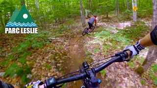
Photos of Leslie Park Mountain Bike
Videos of Leslie Park Mountain Bike

trail: Boucle du castor
52:06 |
148 |
Jun 22, 2024 , Otter Lake
trail: Sentier du Castor Géant
52:06 |
208 |
Jun 22, 2024 , Otter Lake
Recent Trail Reports
| status | trail | date | condition | info | user |
|---|---|---|---|---|---|
| Sentier du Castor Géant | Jun 21, 2026 @ 1:59pm (America/Toronto) Jun 21, 2026 | Ideal | Sebasnorco | ||
| Boucle du castor | Jul 20, 2025 @ 7:32pm Jul 20, 2025 | Ideal | Sebasnorco |
Activity Feed
| username | action | type | title | date |
|---|---|---|---|---|
| Sebasnorco | add | report | activity #97537869 | Jun 21, 2026 @ 7:04pm Jun 21, 2026 |
| Sebasnorco | add | report | activity #80347469 | Sep 14, 2025 @ 10:27am Sep 14, 2025 |
| Sebasnorco | checkin | trail | activity #80205475 | Sep 12, 2025 @ 4:00pm Sep 12, 2025 |
| Sebasnorco | checkin | trail | activity #78888440 | Aug 24, 2025 @ 6:37pm Aug 24, 2025 |
| leepaquette | ridden | trail | activity #77240626 | Aug 2, 2025 @ 10:38am Aug 2, 2025 |
Recent Comments
| username | type | title | comment | date |
|---|---|---|---|---|
| report | La trail est complètement barrée par de... | Aug 10, 2022 @ 9:42am Aug 10, 2022 | ||
| trail | Hidden gem single track. Great for beginner to... | Sep 29, 2020 @ 6:18pm Sep 29, 2020 |
Nearby Areas
| name | distance | ||||
|---|---|---|---|---|---|
| Ottawa River Provincial Park | 1 | 13.2 km | |||
| Wilderness Tours Bike Park | 16 | 8 | 6 | 4 | 13.7 km |
| Moon Lake | 14.7 km | ||||
| Grants Settlement | 4 | 7 | 3 | 15.1 km | |
| The Village Trails | 2 | 17.2 km |
Activity Type Stats
| activitytype | trails | distance | descent | descent distance | total vertical | rating | global rank | state rank | photos | reports | routes | ridelogs |
|---|---|---|---|---|---|---|---|---|---|---|---|---|
| Mountain Bike | 3 | 4 miles | 522 ft | 2 miles | 226 ft | #7,183 | #85 | 13 | 21 | 315 | ||
| Hike | 3 | 4 miles | 522 ft | 2 miles | 226 ft | #17,957 | #210 | 21 | 2 | |||
| Trail Running | 3 | 4 miles | 522 ft | 2 miles | 226 ft | #16,632 | #186 | 21 | 6 |
- By brenthillier
 NSMBA TRAILFORKS & contributors
 - Admins: apply
- #8586 - 3,163 views
- leslie park activity log | embed map of Leslie Park mountain bike trails | leslie park mountain biking points of interest
Downloading of trail gps tracks in kml & gpx formats is enabled for Leslie Park.
You must login to download files.