close
-
Layers w
- Weather Layers
- Pro
- Pro
- Pro
- Pro
- Pro
- Pro
- More Layers
- Pro
- Pro
- Pro
- Pro
-
Upgrade to

3D
Trail Conditions
- Unknown
- Snow Groomed
- Snow Packed
- Snow Covered
- Snow Cover Partial
- Freeze/thaw Cycle
- Icy
- Prevalent Mud
- Wet
- Variable
- Ideal
- Dry
- Very Dry
Trail Flow (Ridden Direction)
Trailforks scans users ridelogs to determine the most popular direction each trail is ridden. A good flowing trail network will have most trails flowing in a single direction according to their intension.
The colour categories are based on what percentage of riders are riding a trail in its intended direction.
The colour categories are based on what percentage of riders are riding a trail in its intended direction.
- > 96%
- > 90%
- > 80%
- > 70%
- > 50%
- < 50%
- bi-directional trail
- no data
Trail Last Ridden
Trailforks scans ridelogs to determine the last time a trail was ridden.
- < 2 days
- < 1 week
- < 2 weeks
- < 1 month
- < 6 months
- > 6 months
Trail Ridden Direction
The intended direction a trail should be ridden.
- Downhill Only
- Downhill Primary
- Both Directions
- Uphill Primary
- Uphill Only
- One Direction
Contribute Details
Colors indicate trail is missing specified detail.
- Description
- Photos
- Description & Photos
- Videos
Trail Popularity ?
Trailforks scans ridelogs to determine which trails are ridden the most in the last 9 months.
Trails are compared with nearby trails in the same city region with a possible 25 colour shades.
Think of this as a heatmap, more rides = more kinetic energy = warmer colors.
- most popular
- popular
- less popular
- not popular
ATV/ORV/OHV Filter
Max Vehicle Width
inches
US Cell Coverage
Legend

Radar Time
Activity Recordings
Trailforks uses anonymized public activity data.
?
Activity Recordings
Trailforks uses anonymized public activity data.
?
Personal Heatmap
▶
Activity Types
all
/
none
▶
Options
2
Date range
month
–
Winter Trails
Warning
A routing network for winter maps does not exist. Selecting trails using the winter trails layer has been disabled.
Missing Trails
Most Popular
Least Popular
Trails are colored based on popularity. The more popular a trail is, the more red. Less popular trails trend towards green.
Jump Magnitude Heatmap
Heatmap of where riders jump on trails. Zoom in to see individual jumps, click circles to view jump details.
BC Backroad Status
![map legend]()
Service Road Atlas is a free to use, community-driven service for viewing and creating reports on the numerous back-country service roads around B.C. and Alberta.

Slope Aspect
Direction the slope faces
Trails Deemphasized
Trails are shown in grey.
Only show trails with no bike usage.
Suggested Layers
Based on selected activity type
Save the current map location and zoom level as your default home location whenever this page is loaded.
SaveA series of singletrack trails located at the northeast end of Duluth along the Amity Creek. The city of Duluth turned over the management of the trails to COGGS in 2009. The trails are slowly being upgraded and expanded to the IMBA standard in order to improve flow and sustainability.
View region descriptions for other activity types
Generic
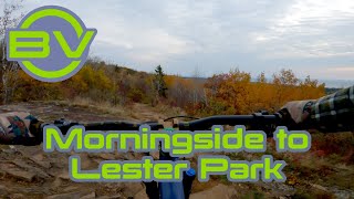
Lester Park is a year-round trail center in eastern Duluth. Mountain Bike
A series of singletrack trails located at the northeast end of Duluth along the Amity Creek. The city of Duluth turned over the management of the trails to COGGS in 2009. The trails are slowly being upgraded and expanded to the IMBA standard in order to improve flow and sustainability. Nordic Ski
A project of the Duluth XC Ski Club, the historic Lester-Amity Chalet is a year-round trail hub and endurance community center in eastern Duluth. Lester-Amity Chalet brings our community together and inspires healthy outdoor recreation, environmental responsibility and active, lifelong learning.Primary Trail Type: Cross-Country
Shuttleable: YES
Land Status: City Managed
Land Manager: City of Duluth
 google parking directions
 Access Info:
Location
2940 Seven Bridges Rd.
Duluth, MN 55804 – click here for map
Winter Open Hours
The Chalet is OPEN 7 DAYS A WEEK during the ski season!! Come enjoy a warm place to take your boots on and off, and some tea or hot cocoa. Open hours are tentatively as follows once we have skiable snow.
Monday-Friday, 3-8pm; Saturdays & Sundays, 9am-4pm
Disclaimer:
Your Great Minnesota Ski Pass fee goes directly toward grooming cross-country ski trails! If you are 16 or older, you must have a Great Minnesota Ski Pass to ski on groomed trails in Minnesota state parks or state forests, or on state or grant-in-aid trails. Sign your Ski Pass and be sure to carry it with you every time you go skiing. (If you prefer, take a photo of both sides of your pass and carry it on your phone.)
Links
- Cyclists of Gitchee Gumee Shores
- Lester Amity Ski Trail Map
- Duluth Cross Country Ski Club Website
- Duluth Cross Country Ski Club Facebook Page
- The Great Minnesota Ski Pass
IMBA Ride Center

Duluth
Activities Click to view
- Mountain Bike
6 trails
- E-Bike
5 trails
- Horse
0 trails
- Hike
15 trails
- Trail Running
15 trails
- Nordic Ski
13 trails
Region Details
- 1
- 4
- 1
Region Status
Open as of Jun 14, 2026Stats
- Avg Trail Rating
- Trails (view details)
- 19
- Trails Mountain Bike
- 6
- Trails E-Bike
- 5
- Trails Hike
- 15
- Trails Trail Running
- 15
- Trails Nordic Ski
- 13
- Total Distance
- 16 miles
- Total Descent
- 1,472 ft
- Total Vertical
- 338 ft
- Highest Trailhead
- 992 ft
- Reports
- 726
- Photos
- 70
- Ridden Counter
- 5,039
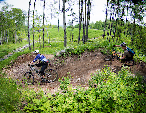
Popular Lester Park Trails Mountain Biking Trails
• 95 ★ 4.9 • 4 miles • 433 ft • 918 •
This is a rolling, bermed, flowing, machine-built stretch of singletrack, generally following the western edge of . This trail is ripping fast both ways: DESCENDING is fantastic and nearly effortless because you can keep your speed...
• 75 ★ 4.2 • 3,865 ft • 135 ft • 705 •
This lower section can be ridden in either direction and can be used in conjunction with the or the to create a complete loop. Riding uphill (from south to north): Starting out at Lester Park, look for this trail heading uphill and into...
• 75 ★ 4.0 • 2 miles • 155 ft • 360 •
One-way trail (downhill only)! Lots of fun jumps and features on your way down.
• 35 ★ 3.6 • 1,106 ft • 23 ft • 357 •
One-way: downhill traffic only! An alternate and more difficult route that leaves and re-connects with Amity East. Features a somewhat technical rocky area and narrow boardwalk, plus some tree roots.
• 20 ★ 3.8 • 2 miles • 156 ft • 316 •
is can be ridden in either direction and is often combined with the to create a full circuit. It can also be combined with the Amity Connector and the for a bigger loop. Riding downhill (south): The trail leaves Seven Bridges Road with...
Lester Park Trails Mountain Bike Routes
Duluth Traverse Featured
★ 4.3 • 41 miles • 3,596 ft • 30 • Point to Point •
Current as of July 2022: the Duluth Traverse can be ridden end-to-end through use of a few short on-road...
6 miles • 499 ft • 3 • Loop •
A nice quick loop of the . Small climb up the traverse trail followed by a descent down and !Rocks.
• 15 miles • 1,740 ft • 7 •
• 19 miles • 1,444 ft • 8 •
• 20 miles • 1,972 ft • 13 •
Photos of Lester Park Trails Mountain Bike
Videos of Lester Park Trails Mountain Bike
youtuber
![One of my ALL TIME Favorite Duluth Trails! ||...]()
trail: Amity East (upper)
11:17 |
384 |
Jun 20, 2023 , Duluth
youtuber
![One of my favorite rides in Minnesota]()
17:36 |
132 |
Nov 20, 2022
youtuber
![Another fun downhill trail in Duluth that may...]()
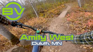
trail: Amity West Trail
7:29 |
296 |
Nov 7, 2022 , Duluth
youtuber
![This is NOT a climbing trail!]()

trail: Amity East (lower)
9:33 |
255 |
Oct 31, 2022 , Duluth

13:01 |
160 |
Oct 24, 2022
trail: Amity East (lower)
3:42 |
254 |
Apr 20, 2021 , Duluth
youtuber
![Is Lester better?]()

trail: Amity East (lower)
5:06 |
416 |
Nov 10, 2020 , Duluth
youtuber
![Lester Park has the best blue trails in Duluth]()

15:05 |
398 |
Jun 14, 2020
Recent Trail Reports
| status | trail | date | condition | info | user |
|---|---|---|---|---|---|
| !Rocks | May 26, 2026 @ 2:22pm (America/Atikokan) May 26, 2026 | Ideal | michaeldoyle | ||
| Lester River Trail | May 26, 2026 @ 2:22pm (America/Atikokan) May 26, 2026 | Ideal | michaeldoyle | ||
| Amity East (upper) | May 7, 2026 @ 11:21am (America/Atikokan) May 7, 2026 | Ideal | Smedy | ||
| Amity East (lower) | Nov 16, 2025 @ 12:22pm (Pacific/Midway) Nov 16, 2025 | Ideal | evanjpak MW HIKING | ||
| Amity West Trail | Oct 1, 2025 @ 10:54am (America/Atikokan) Oct 1, 2025 | Ideal | Smedy |
National Scenic Trails & Official Routes
-
Duluth Traverse
- Mountain Bike
- E-Bike
Activity Feed
| username | action | type | title | date |
|---|---|---|---|---|
| evanjpak | vote | trail | activity #96826319 and 2 more | Jun 12, 2026 @ 1:53pm Jun 12, 2026 |
| datdudegg22 | wishlist | route | activity #95713069 | May 28, 2026 @ 9:29am May 28, 2026 |
| michaeldoyle | add | report | activity #95603844 and 1 more | May 26, 2026 @ 5:57pm May 26, 2026 |
| jonmc7583 | wishlist | trail | activity #94865948 | May 16, 2026 @ 6:01pm May 16, 2026 |
| cp1994 | comment | report | activity #94526515 | May 11, 2026 @ 4:57pm May 11, 2026 |
Recent Comments
| username | type | title | comment | date |
|---|---|---|---|---|
| report | Closed according to trailbot | May 11, 2026 @ 4:57pm May 11, 2026 | ||
| trail | hi | Apr 8, 2022 @ 8:15am Apr 8, 2022 | ||
| trail | Took Lester Creek trail north which was a lot... | Sep 25, 2020 @ 7:22am Sep 25, 2020 | ||
| trail | Its the closest to old style single-track you... | Sep 14, 2020 @ 10:22am Sep 14, 2020 | ||
| trail | The trails keep ger neutered. They just took... | Aug 13, 2020 @ 8:16am Aug 13, 2020 |
Nearby Areas
| name | distance | ||||
|---|---|---|---|---|---|
| Congdon Park | 3.6 km | ||||
| Hartley Park | 3 | 10 | 6 | 4.3 km | |
| Bagley Nature Area | 1 | 4.3 km | |||
| Chester Park Area | 2 | 4.9 km | |||
| French River Headwaters AMA | 2 | 9 km |
Local Products
Activity Type Stats
| activitytype | trails | distance | descent | descent distance | total vertical | rating | global rank | state rank | photos | reports | routes | ridelogs |
|---|---|---|---|---|---|---|---|---|---|---|---|---|
| Mountain Bike | 6 | 9 miles | 886 ft | 3 miles | 325 ft | #4,836 | #1,736 | 70 | 716 | 1 | 8,138 | |
| E-Bike | 5 | 7 miles | 574 ft | 2 miles | 325 ft | #7,305 | #2,128 | 643 | 76 | |||
| Hike | 15 | 12 miles | 1,237 ft | 4 miles | 325 ft | #10,670 | #4,231 | 698 | 184 | |||
| Trail Running | 15 | 12 miles | 1,237 ft | 4 miles | 325 ft | #9,515 | #3,455 | 698 | 362 | |||
| Nordic Ski | 13 | 7 miles | 584 ft | 3 miles | 338 ft | #531 | #165 | 6 | 798 |
Frequently Asked Questions About Lester Park Trails
▼
What are the highest rated mountain biking trails in Lester Park Trails?
The highest rated mountain biking trails in Lester Park Trails are:
- Lester River Trail (4.6/5)
- Amity East (lower) (4.1/5)
- Amity East (upper) (4/5)
- Amity West Trail (3.8/5)
- !Rocks (3.8/5)
▼
What is the best time of the year to ride in Lester Park Trails?
Based on ride log data, the most popular months to ride in Lester Park Trails are:
- July (182 activities)
- August (165 activities)
- June (121 activities)
▼
Where can I park to ride in Lester Park Trails?
There are 4 parking locations listed in Lester Park Trails. The most popular parking spots are:
- E Skyline Parkway parking lot (Amity, Lester, Duluth Traverse trails)
- Lester Park Parking Lot
- Lester Road Parking
- Lester Amity Parking
▼
What is the longest trail in Lester Park Trails?
The longest trail in Lester Park Trails is Lester River Trail at 3.6 miles. View all trails sorted by distance.
Activities
Trails
Points of Interest
- By WanderingMan
 BSMTB & contributors
 - Admins: COGGS, CityofDuluth, COGGS
- #6317 - 19,394 views
- lester park trails activity log | embed map of Lester Park Trails mountain bike trails | lester park trails mountain biking points of interest
Downloading of trail gps tracks in kml & gpx formats is enabled for Lester Park Trails.
You must login to download files.