close
-
Layers w
- Weather Layers
- Pro
- Pro
- Pro
- Pro
- Pro
- Pro
- More Layers
- Pro
- Pro
- Pro
- Pro
-
Upgrade to

3D
Trail Conditions
- Unknown
- Snow Groomed
- Snow Packed
- Snow Covered
- Snow Cover Partial
- Freeze/thaw Cycle
- Icy
- Prevalent Mud
- Wet
- Variable
- Ideal
- Dry
- Very Dry
Trail Flow (Ridden Direction)
Trailforks scans users ridelogs to determine the most popular direction each trail is ridden. A good flowing trail network will have most trails flowing in a single direction according to their intension.
The colour categories are based on what percentage of riders are riding a trail in its intended direction.
The colour categories are based on what percentage of riders are riding a trail in its intended direction.
- > 96%
- > 90%
- > 80%
- > 70%
- > 50%
- < 50%
- bi-directional trail
- no data
Trail Last Ridden
Trailforks scans ridelogs to determine the last time a trail was ridden.
- < 2 days
- < 1 week
- < 2 weeks
- < 1 month
- < 6 months
- > 6 months
Trail Ridden Direction
The intended direction a trail should be ridden.
- Downhill Only
- Downhill Primary
- Both Directions
- Uphill Primary
- Uphill Only
- One Direction
Contribute Details
Colors indicate trail is missing specified detail.
- Description
- Photos
- Description & Photos
- Videos
Trail Popularity ?
Trailforks scans ridelogs to determine which trails are ridden the most in the last 9 months.
Trails are compared with nearby trails in the same city region with a possible 25 colour shades.
Think of this as a heatmap, more rides = more kinetic energy = warmer colors.
- most popular
- popular
- less popular
- not popular
ATV/ORV/OHV Filter
Max Vehicle Width
inches
US Cell Coverage
Legend

Radar Time
Activity Recordings
Trailforks uses anonymized public activity data.
?
Activity Recordings
Trailforks uses anonymized public activity data.
?
Personal Heatmap
▶
Activity Types
all
/
none
▶
Options
2
Date range
month
–
Winter Trails
Warning
A routing network for winter maps does not exist. Selecting trails using the winter trails layer has been disabled.
Missing Trails
Most Popular
Least Popular
Trails are colored based on popularity. The more popular a trail is, the more red. Less popular trails trend towards green.
Jump Magnitude Heatmap
Heatmap of where riders jump on trails. Zoom in to see individual jumps, click circles to view jump details.
BC Backroad Status
![map legend]()
Service Road Atlas is a free to use, community-driven service for viewing and creating reports on the numerous back-country service roads around B.C. and Alberta.

Slope Aspect
Direction the slope faces
Trails Deemphasized
Trails are shown in grey.
Only show trails with no bike usage.
Suggested Layers
Based on selected activity type
Save the current map location and zoom level as your default home location whenever this page is loaded.
SavePopular Trail Networks
view all areas »
No description for Liguria has been added yet!
Login or register to submit one.
This region uses the Uk/Euro style trail grading system.
Region Details
- 710
- 28
- 643
- 1,268
- 391
- 102
- 6
Stats
- Avg Trail Rating
- Trails (view details)
- 3,262
- Trails Mountain Bike
- 3,222
- Trails E-Bike
- 2,534
- Trails Gravel Bike
- 111
- Trails Adaptive Bike
- 18
- Trails Winter Fat Bike
- 5
- Trails Horse
- 196
- Trails Hike
- 2,613
- Trails Trail Running
- 2,526
- Trails Dirtbike/Moto
- 68
- Trails Observed Trials
- 23
- Trails ATV/ORV/OHV
- 50
- Trails Snowmobile
- 11
- Trails Snowshoe
- 19
- Trails Downhill Ski
- 12
- Trails Backcountry Ski
- 18
- Trails Nordic Ski
- 9
- Total Distance
- 3,549 miles
- Total Descent
- 1,380,820 ft
- Total Vertical
- 7,022 ft
- Highest Trailhead
- 7,023 ft
- Reports
- 53,623
- Photos
- 10,595
- Ridden Counter
- 596,268
Articles
Video: Brice Shirbach Explores The MTB Trails of Finale Ligure in 'Underexposed'
Jun 2, 2025 from pinkbike.com
The birthplace of pizza, and a vibrant MTB community.
Video: Suspension Testing in Sanremo With Intense Factory Racing
Apr 3, 2025 from pinkbike.com
IFR's Joe Breeden hits the rocky trails of Sanremo to dial in pre season suspension settings.
Video: Designing the Course for the Enduro World Cup in Finale Ligure with Race Director Francesco Gozio
Dec 6, 2023 from pinkbike.com
This local is responsible for planning all of the details to make sure that the renowned race runs smoothly.
Video: Shredding the Italian Riviera on an eMTB
Apr 17, 2022 from pinkbike.com
Michal Prokop rides an iconic region.
Sub Regions
- Genova (1,117)
- Arenzano (51)
- Campo Ligure (94)
- Campomorone (17)
- Ceranesi (49)
- Chiavari (20)
- Cogoleto (34)
- CogoletOOutdoor Area (34)
- Cravasco (4)
- Crocefieschi (26)
- Genova (403)
- Leivi (16)
- Masone (3)
- Mele (33)
- Moneglia (29)
- Montoggio (23)
- Recco (28)
- Rezzoaglio (17)
- Ronco Scrivia (33)
- Rovegno (40)
- Sant'Olcese (118)
- Santa Margherita Ligure (22)
- SAVIGNONE (14)
- Sestri Levante (84)
- Tiglieto (8)
- Torriglia (36)
- Uscio (15)
- Voltri (6)
- Imperia (443)
- Bordighera (43)
- Cipressa (13)
- Coldirodi (11)
- Dolceacqua (53)
- Dolceacqua (40)
- Imperia (14)
- Molini di Triora (78)
- Molini (55)
- Molini Freeride (13)
- Nava (64)
- Nava freeride Park (47)
- Perinaldo (1)
- Pieve di Teco (51)
- Valle Arroscia (48)
- Rocchetta Nervina (12)
- San Bartolomeo al Mare (8)
- Golfo Dianese (6)
- San Romolo (3)
- Sanremo (38)
- Sanremo Bike Resort (36)
- Santo Stefano Al Mare (7)
- Taggia (3)
- Vallecrosia (2)
- Ventimiglia (14)
- Val Prino (33)
- Bordighera (43)
- La Spezia (463)
- Adelano (5)
- Bolano (9)
- Bonassola (7)
- Brugnato (3)
- Deiva Marina (42)
- Framura (14)
- La Spezia (102)
- Cinque Terre (60)
- Lerici (45)
- Levanto (108)
- Levanto (90)
- Monte Croce Park (18)
- Ortonovo (16)
- Pignone (17)
- Portovenere (11)
- Isola Palmaria (1)
- Riccò Del Golfo (2)
- Ricco' Del Golfo (22)
- Sarzana (26)
- Sesta Godano (3)
- Vezzano Ligure (4)
- Monte Le Croci Trail Park (2)
- Adelano (5)
- Savona (1,269)
- Alassio (76)
- Baia del Sole (40)
- Albenga (10)
- Albisola Superiore (51)
- Albissola (1)
- Altare (21)
- Monte Burot (21)
- Andora (90)
- Andora Bike Resort (87)
- Arnasco (3)
- Balestrino (6)
- Bardineto (25)
- Borghetto Santo Spirito (38)
- Varatella Trail Area (38)
- Borgio Verezzi (2)
- Cairo Montenotte (45)
- Calizzano (4)
- Campochiesa (4)
- Castelvecchio di Rocca Barbena (9)
- Celle Ligure (99)
- CelleLand (37)
- Cengio (9)
- Ceriale (9)
- Cisano Sul Neva (4)
- Conna (1)
- Cosseria (10)
- Dego (30)
- SanDego Valley (30)
- Erli (17)
- Feglino (6)
- Ferrania (1)
- Finale Ligure (283)
- Finale Outdoor Region (251)
- Le Manie (8)
- San Bernardino (5)
- Garlenda (6)
- Laigueglia (8)
- Loano (3)
- Magliolo (1)
- Mallare (25)
- Melogno (14)
- Millesimo (21)
- Wildbormida Range (20)
- Nasino (2)
- Noli (1)
- Onzo (23)
- Castell'Ermo (22)
- Osiglia (18)
- Pallare (3)
- Pietra Ligure (23)
- Pontinvrea (1)
- Quiliano (19)
- Ranzi (11)
- Roccavignale (5)
- Rocchetta Cairo (20)
- Rokkaround (10)
- Salea (5)
- San Fedele (21)
- SanFé Micro Park (21)
- San Filippo (2)
- Sassello (26)
- Savona (75)
- Spotorno (10)
- Spotorno Outdoor (3)
- Stella (51)
- Stella Trails Area (38)
- Toirano (35)
- Vado Ligure (59)
- Varazze (107)
- Varazze Trail Area (73)
- Varigotti (9)
- Verezzi (9)
- Verzi (10)
- Vezzi Portio (11)
- Zuccarello (17)
- Riserva dell'Adelasia (39)
- Alassio (76)
Popular Liguria Mountain Biking Trails
• 100 ★ 4.5 • 4 miles • 95 ft • 7,751 •
Maybe the most iconic and known trail in Finale. Every rider that spends time in Finale must ride this. In its 7km length, you’ll find an experience packed with fun, speed, gnar, views for a great all-round experience. Used as stage 1...
• 100 ★ 4.6 • 1 mile • 0 ft • 6,628 •
The second trail from the left once we leave the Nato Base is . Maybe the easiest track of the four, has a very similar style to the other trails of the area. Features a lot of flowy lines, no jumps or mandatory gaps. It ends on a...
• 100 ★ 4.8 • 2 miles • 17 ft • 5,943 •
One of the most complete enduro stages ever built in Finale. Designed for the EWS in 2015, it is one of the fastest, most challenging stages to the date. Enjoyed by pro racers, enjoyable by a very wide variety of riders, in its 7 kms,...
• 95 ★ 4.7 • 2 miles • 0 ft • 5,069 •
One of the first trails built in the Nato Base area. The longest trail of the 4 that roll down straight from the Base itself, and one of the most fun. Fast lines, banks, tiny jumps and a lot of flow, definitely a must-ride of the area....
• 100 ★ 4.7 • 3,002 ft • 0 ft • 5,064 •
Cravarezza takes its name from the crossroad that the trails starts from: Colla Cravarezza. By many considered the first part of the Trail, it was indeed used as the stage in 2015. It is definitely a nice start of a beautiful fast and...
• 95 ★ 4.2 • 2 miles • 113 ft • 4,370 •
This first part of Crestino trail comprises of many different sections. Is the main access not only to the area of Vezzi and the east but also to the Mallare Area. After the first traverse that ends to Colla and 5 minutes of riding...
• 100 ★ 4.8 • 5,089 ft • 19 ft • 4,122 •
A little more than 1 km, it is the perfect end to an already great trail as Isallo Extasi is. It starts at the end of the tarmac road that leads to the Ferrata degli Artisti and features some gullies, exposed sections, roots and steep...
Liguria Mountain Bike Routes
★ 5.0 • 43 miles • 6,471 ft • 8 • Point to Point •
Eccellente traversata all-mountain. Arrivati in treno a Rossiglione si segue la strada Berlino che poi...
★ 5.0 • 36 miles • 5,221 ft • 17 • Loop •
Ideale per Ebike o (Enduro livello allenamento alto). Partenza dal negozio TrekUpBike di Ceriale, si...
14 miles • 2,321 ft • 4 • Loop •
Un tour E-bike impegnativo e tecnico dove si toccano trail tra i più belli della Lerici-Ameglia Trail...
★ 5.0 • 22 miles • 6,791 ft • 3 • Loop •
300md+ pousage, neige l'hiver Jolie sommet, panoramique avec de sentiers techniques et ludique, quoi de...
★ 4.3 • 13 miles • 2,234 ft • 7 • Point to Point •
Route connecting Roller Coaster Kill Bill 1 Madonna Della Guardia Pina Morta Pina Morta Lower Neanderthaler
★ 5.0 • 29 miles • 8,278 ft • 3 • Loop •
Partenza da Molini di Triora.
Photos of Liguria Mountain Bike
Videos of Liguria Mountain Bike
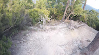
trail: Base Nato
11:41 |
16 |
Apr 12, 2026
trail: Isallo Extasy
15:02 |
28 |
Oct 18, 2025
trail: Little Champery
6:05 |
48 |
Oct 18, 2025
trail: Toboga di Canova
11:15 |
23 |
Oct 17, 2025
trail: Madonna della Guardia
3:05 |
41 |
Oct 17, 2025
trail: Base Nato
7:21 |
23 |
Oct 17, 2025
trail: Pino Morto
3:19 |
35 |
Oct 17, 2025
trail: Oribago 2
5:53 |
21 |
Oct 17, 2025
Current Trail Warnings
| status | trail | date | condition | user | info |
|---|---|---|---|---|---|
| Ciazze CogoletOOutdoor Area | Jun 16, 2026 @ 8:39am (Europe/Rome) 2 days | Dry | Gianlumorra | una giungla di felci... a tratti nn... | |
| Bassa Tensione Arenzano | Jun 15, 2026 @ 11:16am (Europe/Rome) 3 days | Dry | albicicloalp1991 | Un po' eroso nel primissimo tratto, poi... | |
| Acqua dei Signori Monte Burot | Jun 14, 2026 @ 9:04am (Europe/Monaco) Jun 14, 2026 | Variable | abrondi | E-Bike Distrutto, in discesa comunque fattibile,... |
Recent Trail Reports
Activity Feed
| username | action | type | title | date |
|---|---|---|---|---|
| McOne | add | report | activity #97207623 | Jun 17, 2026 @ 1:48pm 5 hours |
| Seand69 | add | photo | activity #97203230 and 4 more | Jun 17, 2026 @ 12:31pm 6 hours |
| felixmcr96 | wishlist | trail | activity #97202851 and 2 more | Jun 17, 2026 @ 12:26pm 6 hours |
| DbSgsB | wishlist | trail | activity #97200156 | Jun 17, 2026 @ 11:48am 7 hours |
| crashtor | ridden | trail | activity #97199771 | Jun 17, 2026 @ 11:43am 7 hours |
Recent Comments
| username | type | title | comment | date |
|---|---|---|---|---|
| report | Perfetto pulito rifatto da poco | Jun 14, 2026 @ 10:41am Jun 14, 2026 | ||
| trail | Abbastanza tecnico...tutto naturale! | Jun 14, 2026 @ 4:14am Jun 14, 2026 | ||
| report | Confirmed 11 june 2026 | Jun 11, 2026 @ 3:11am Jun 11, 2026 | ||
| trail | ho fatto richiesta per il cambio di... | Jun 10, 2026 @ 2:42am Jun 10, 2026 | ||
| trail | ok grazie | Jun 10, 2026 @ 2:38am Jun 10, 2026 |
Local Badges
-

10 Green Trails72 awarded -

Top 10 Trails0 awarded -

Epic Ride Climb 2k982 awarded -

10 Blue Trails56 awarded -
Epic Ride Climb 2k248 awarded -
Epic Ride Climb 2k3 awarded
Bike & Skill Parks
| name | type | city | rating |
|---|---|---|---|
| Sanremo Bike Resort | bike park | Sanremo | |
| Molini Freeride | bike park | Molini di Triora | |
| PUMP TRACK Borgio Verezzi | skill park | Finale Ligure | |
| Pump Track | skill park | Albenga | |
| Pumptrack Break Bike Sestri | skill park | Sestri Levante |
Local Trail Supporters
- p
![]()
![]()
- Osteria Asenetto
![]()
![]()
![]()
![]()
![]()
![]()
![]()
- rider apuani
![]()
![]()
![]()
![]()
![]()
- a.s.d. AndoraRace
- B&B Giutte
Activity Type Stats
| activitytype | trails | distance | descent | descent distance | total vertical | rating | global rank | state rank | photos | reports | routes | ridelogs |
|---|---|---|---|---|---|---|---|---|---|---|---|---|
| Mountain Bike | 3,221 | 3,452 miles | 1,345,630 ft | 1,917 miles | 7,021 ft | 8,685 | 53,569 | 391 | 295,831 | |||
| E-Bike | 2,534 | 2,719 miles | 1,018,068 ft | 1,490 miles | 7,021 ft | 1,572 | 49,385 | 133 | 77,908 | |||
| Gravel Bike | 111 | 241 miles | 28,717 ft | 64 miles | 4,564 ft | 4,740 | 13 | 2,159 | ||||
| Adaptive Bike | 18 | 106 | 6 | |||||||||
| Winter Fat Bike | 5 | 147 | 3 | |||||||||
| Horse | 196 | 254 miles | 58,038 ft | 112 miles | 6,926 ft | 3,062 | 2 | 6 | ||||
| Hike | 2,613 | 2,928 miles | 1,061,499 ft | 1,542 miles | 7,021 ft | 135 | 48,425 | 28 | 13,330 | |||
| Trail Running | 2,526 | 2,828 miles | 1,027,372 ft | 1,487 miles | 7,021 ft | 157 | 48,228 | 34 | 7,429 | |||
| Dirtbike/Moto | 68 | 111 miles | 18,369 ft | 38 miles | 6,919 ft | 2,864 | 4 | 32 | ||||
| Observed Trials | 23 | 29 miles | 4,547 ft | 13 miles | 3,533 ft | 240 | 17 | |||||
| ATV/ORV/OHV | 50 | 72 miles | 15,115 ft | 29 miles | 6,742 ft | 2,817 | 7 | |||||
| Snowmobile | 11 | 14 miles | 3,337 ft | 8 miles | 2,628 ft | 16 | 1 | |||||
| Snowshoe | 19 | 31 miles | 4,925 ft | 13 miles | 3,704 ft | 41 | 101 | |||||
| Downhill Ski | 12 | 19 miles | 2,818 ft | 6 miles | 3,704 ft | 20 | 398 | |||||
| Backcountry Ski | 18 | 32 miles | 4,587 ft | 13 miles | 3,704 ft | 18 | 426 | |||||
| Nordic Ski | 9 | 13 miles | 2,333 ft | 7 miles | 2,628 ft | 14 | 303 |
Activities
- Liguria Mountain Biking Trails
- Liguria E-Biking Trails
- Liguria Gravel Biking Trails
- Liguria Adaptive Biking Trails
- Liguria Winter Fat Biking Trails
- Liguria Horseback Trails
- Liguria Hiking Trails
- Liguria Trail Running Trails
- Liguria Dirtbiking Trails
- Liguria Observed Trials Trails
- Liguria ATVing/Offroading Trails
- Liguria Snowmobiling Trails
- Liguria Snowshoeing Trails
- Liguria Skiing Trails
- Liguria Backcountry Skiing Trails
- Liguria Nordic Skiing Trails
Trails
Points of Interest
- By denitopia
 TRAILFORKS VTA & contributors
 - Admins: denitopia, marcoangeletti, cemoorelife, denitopia
- #7665 - 44,498 views
- liguria activity log | embed map of Liguria mountain bike trails | liguria mountain biking points of interest
Downloading of trail gps tracks in kml & gpx formats is enabled for Liguria.
You must login to download files.