close
-
Layers w
- Weather Layers
- Pro
- Pro
- Pro
- Pro
- Pro
- Pro
- More Layers
- Pro
- Pro
- Pro
- Pro
-
Upgrade to

3D
Trail Conditions
- Unknown
- Snow Groomed
- Snow Packed
- Snow Covered
- Snow Cover Partial
- Freeze/thaw Cycle
- Icy
- Prevalent Mud
- Wet
- Variable
- Ideal
- Dry
- Very Dry
Trail Flow (Ridden Direction)
Trailforks scans users ridelogs to determine the most popular direction each trail is ridden. A good flowing trail network will have most trails flowing in a single direction according to their intension.
The colour categories are based on what percentage of riders are riding a trail in its intended direction.
The colour categories are based on what percentage of riders are riding a trail in its intended direction.
- > 96%
- > 90%
- > 80%
- > 70%
- > 50%
- < 50%
- bi-directional trail
- no data
Trail Last Ridden
Trailforks scans ridelogs to determine the last time a trail was ridden.
- < 2 days
- < 1 week
- < 2 weeks
- < 1 month
- < 6 months
- > 6 months
Trail Ridden Direction
The intended direction a trail should be ridden.
- Downhill Only
- Downhill Primary
- Both Directions
- Uphill Primary
- Uphill Only
- One Direction
Contribute Details
Colors indicate trail is missing specified detail.
- Description
- Photos
- Description & Photos
- Videos
Trail Popularity ?
Trailforks scans ridelogs to determine which trails are ridden the most in the last 9 months.
Trails are compared with nearby trails in the same city region with a possible 25 colour shades.
Think of this as a heatmap, more rides = more kinetic energy = warmer colors.
- most popular
- popular
- less popular
- not popular
ATV/ORV/OHV Filter
Max Vehicle Width
inches
US Cell Coverage
Legend

Radar Time
Activity Recordings
Trailforks uses anonymized public activity data.
?
Activity Recordings
Trailforks uses anonymized public activity data.
?
Personal Heatmap
▶
Activity Types
all
/
none
▶
Options
2
Date range
month
–
Winter Trails
Warning
A routing network for winter maps does not exist. Selecting trails using the winter trails layer has been disabled.
Missing Trails
Most Popular
Least Popular
Trails are colored based on popularity. The more popular a trail is, the more red. Less popular trails trend towards green.
Jump Magnitude Heatmap
Heatmap of where riders jump on trails. Zoom in to see individual jumps, click circles to view jump details.
BC Backroad Status
![map legend]()
Service Road Atlas is a free to use, community-driven service for viewing and creating reports on the numerous back-country service roads around B.C. and Alberta.

Slope Aspect
Direction the slope faces
Trails Deemphasized
Trails are shown in grey.
Only show trails with no bike usage.
Suggested Layers
Based on selected activity type
Save the current map location and zoom level as your default home location whenever this page is loaded.
SaveFür Informationen rund um die Wege, Trails und Mountainbikestrecken in den Linzer Hausbergen, setzt euch mit "UpperTrails" (vormals MTB Linz) in Kontakt, die sich um die Wegerhaltung der Trails, sowie um die Kommunikation zwischen Mountainbiker, Politik und Grundeigentümer kümmern.
http://www.uppertrails.at
http://www.uppertrails.at
Links
This region uses the Uk/Euro style trail grading system.
Region Supporters & Maintainers
![]()
UpperTrailsMaintainer![]()
UpperTrailsBuilder
Activities Click to view
- Mountain Bike
56 trails
- E-Bike
55 trails
- Gravel Bike
30 trails
- Adaptive Bike
17 trails
- Winter Fat Bike
41 trails
- Horse
15 trails
- Hike
60 trails
- Trail Running
60 trails
Region Details
- 20
- 11
- 10
- 11
- 4
Region Status
Open as of Jun 23, 2026Stats
- Avg Trail Rating
- Trails (view details)
- 64
- Trails Mountain Bike
- 56
- Trails E-Bike
- 55
- Trails Gravel Bike
- 30
- Trails Adaptive Bike
- 17
- Trails Winter Fat Bike
- 41
- Trails Horse
- 15
- Trails Hike
- 60
- Trails Trail Running
- 60
- Total Distance
- 26 miles
- Total Descent Distance
- 14 miles
- Total Descent
- 7,761 ft
- Total Vertical
- 2,206 ft
- Highest Trailhead
- 3,025 ft
- Reports
- 3,764
- Photos
- 340
- Ridden Counter
- 1,951
Sub Regions
-
Linzerberg-Trails
- 5
- 1
-
Pfenningberg-Trails
- 1
- 1
- 2
-
Radtechnik-Parcours Kirchschlag bei Linz
- 1
- 1
- 1
-
Roadlberg-Trails
- 1
- 2
- 7
- 3
Popular Linz Mountain Biking Trails
• 100 ★ 4.9 • 4,216 ft • 6 ft • 120 •
Als erster offizieller Mountainbike-Singletrail im Linzer Zentralraum wurde der am 26. Oktober 2021 freigegeben. Die 1,2 Kilometer und zirka 200 Tiefenmeter lange MTB-Strecke wurde in mehreren hundert Arbeitsstunden mittels Handarbeit...
• 100 ★ 5.0 • 1,926 ft • 0 ft • 99 •
1. Mai – 30. September: 8:00 bis 20:00 Uhr 1. Oktober – 30. April: 9:00 bis 17:00 Uhr Nightrides sind grundsätzlich verboten und wir bitten um genaue Einhaltung. Im Gegenzug gibts dafür gibt es keine Wintersperre, bzw. sind auch...
• 85 ★ 5.0 • 538 ft • 0 ft • 92 •
Öffnungszeiten: 1. Mai – 30. September: 8:00 bis 20:00 Uhr 1. Oktober – 30. April: 9:00 bis 17:00 Uhr Die Benützung ist kostenlos. und müssen via MTB Linz bei Wegerhalter und Grundeigentümer angefragt werden. und wir bitten um...
• 45 ★ 2.7 • 1,699 ft • 0 ft • 45 •
This Trail is part of the offical and legal route "Linzer Runde B (Granitland)". Keep in mind that it is a shared trail – there are also hikers and some people ride it also uphill. Trail is mostly wide and not technical. Very easy,...
• 85 ★ 5.0 • 1 mile • 232 ft • 44 •
Öffnungszeiten: 1. Mai – 30. September: 8:00 bis 20:00 Uhr 1. Oktober – 30. April: 9:00 bis 17:00 Uhr Die Benützung ist kostenlos. und müssen via MTB Linz bei Wegerhalter und Grundeigentümer angefragt werden. und wir bitten um...
• 30 ★ 3.3 • 2,772 ft • 0 ft • 41 •
1. Mai – 30. September: 8:00 bis 20:00 Uhr 1. Oktober – 30. April: 9:00 bis 17:00 Uhr Nightrides sind grundsätzlich verboten und wir bitten um genaue Einhaltung. Im Gegenzug gibts dafür gibt es keine Wintersperre, bzw. sind auch...
• 95 ★ 5.0 • 400 ft • 0 ft • 40 •
2 Dirtjump Lines Öffnungszeiten: 1. Mai – 30. September: 8:00 bis 20:00 Uhr 1. Oktober – 30. April: 9:00 bis 17:00 Uhr Die Benützung ist kostenlos. und müssen via MTB Linz bei Wegerhalter und Grundeigentümer angefragt werden....
• 60 ★ 2.5 • 2,667 ft • 0 ft • 40 •
This Trail is part of the offical and legal route "Linzer Runde B (Granitland)". Keep in mind that it is a shared trail – there are also hikers and some people ride it also uphill. Trail is mostly wide (doubletrack) on a meadow and...
Linz Mountain Bike Routes
★ 2.0 • 20 miles • 3,225 ft • 3 • Loop •
Vom tiefsten zum höchsten Punkt des Granitlandes Süd – von der Donau auf die Gis – führt diese...
★ 2.0 • 44 miles • 5,905 ft • 6 • Loop •
Eine anspruchsvolle Tagestour umrundet das Granitland Süd und startet gleich mit einem knackigen Anstieg...
★ 2.0 • 26 miles • 3,910 ft • 5 • Loop •
Die Runde startet auf der Eidenberger Alm, man kann aber an jeder Stelle der Strecke einsteigen. Gleich zu...
★ 2.0 • 18 miles • 3,395 ft • 6 • Loop •
Die Linzer Runde führt alle passionierten Moutainbiker aus dem Zentrum der Landeshauptstadt...
★ 1.0 • 20 miles • 2,149 ft • 0 • Loop •
Die Runde führt auf aussichtsreiche Höhen und durch fünf Flusstäler. Einstieg mit Parkmöglichkeit in...
Photos of Linz Mountain Bike
Videos of Linz Mountain Bike
trail: Hornissen-Trail
0:30 |
10 |
Apr 28, 2026
trail: Roadlpartie-Trail
0:35 |
17 |
Oct 13, 2025
trail: Roadlflight-Trail
0:06 |
22 |
Aug 1, 2025
trail: Roadlflow-Trail
0:22 |
23 |
May 18, 2025
trail: Hornissen-Trail
2:44 |
24 |
Mar 15, 2025
trail: Techniktrail
0:05 |
65 |
Mar 15, 2025
0:06 |
507 |
Oct 20, 2019
youtuber
![Herbstlich, frisch & knackig - Roadlberg...]()
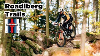
trail: Roadlpartie-Trail
13:36 |
67 |
Oct 25, 2025 , Linz
Recent Trail Reports
Activity Feed
| username | action | type | title | date |
|---|---|---|---|---|
| Mindcracker | ridden | trail | activity #97883722 | Jun 27, 2026 @ 1:47am 13 hours |
| Mindcracker | wishlist | skillpark | activity #97883702 | Jun 27, 2026 @ 1:46am 13 hours |
| Mindcracker | wishlist | region | activity #97883683 | Jun 27, 2026 @ 1:46am 13 hours |
| Mindcracker | wishlist | region | activity #97883430 | Jun 27, 2026 @ 1:40am 13 hours |
| Mindcracker | wishlist | region | activity #97883396 | Jun 27, 2026 @ 1:40am 13 hours |
Recent Comments
| username | type | title | comment | date |
|---|---|---|---|---|
| trail | Achtung: Per 21. Februar 2026 wurden die... | Feb 21, 2026 @ 12:29am Feb 21, 2026 | ||
| trail | Achtung: Per 21. Februar 2026 wurden die... | Feb 21, 2026 @ 12:29am Feb 21, 2026 | ||
| trail | Achtung: Per 21. Februar 2026 wurden die... | Feb 21, 2026 @ 12:28am Feb 21, 2026 | ||
| trail | Achtung: Per 21. Februar 2026 wurden die... | Feb 21, 2026 @ 12:27am Feb 21, 2026 | ||
| trail | Achtung: Per 21. Februar 2026 wurden die... | Feb 21, 2026 @ 12:27am Feb 21, 2026 |
Local Badges
-

Epic Mountain Bike Climb 2k37 awarded -

Climbing 10k Badge28 awarded -

Mountain Biking 100k Badge4 awarded -

Epic Ride Descent 2k37 awarded -

Descent 10k Badge28 awarded -

Descent 100k Badge4 awarded
Bike & Skill Parks
| name | type | city | rating |
|---|---|---|---|
| hello yellow Pumptrack Linz | skill park | Linz | |
| CrossCountry Bikepark Lichtenberg | skill park | Linz | |
| Bike-Motorik-Park St. Florian / Taunleiten | skill park | Linz | |
| Pumptrack Alberndorf | skill park | Linz | |
| Dirtpark + Pumptrack Linz/Plesching | skill park | Linz |
Local Trail Supporters
- G-Tec Estrich
- Lines Magazine
![]()
Activity Type Stats
| activitytype | trails | distance | descent | descent distance | total vertical | rating | global rank | state rank | photos | reports | routes | ridelogs |
|---|---|---|---|---|---|---|---|---|---|---|---|---|
| Mountain Bike | 56 | 23 miles | 5,912 ft | 11 miles | 2,123 ft | #1,040 | #8 | 305 | 3,761 | 6 | 11,071 | |
| E-Bike | 55 | 23 miles | 5,804 ft | 11 miles | 2,123 ft | #300 | #5 | 3,733 | 6 | 1,030 | ||
| Gravel Bike | 30 | 5 miles | 1,115 ft | 1 mile | 1,699 ft | #78 | #18 | 91 | 6 | 25 | ||
| Adaptive Bike | 17 | 10 miles | 951 ft | 3 miles | 1,598 ft | #51 | #50 | 575 | 1 | |||
| Winter Fat Bike | 41 | 11 miles | 2,385 ft | 5 miles | 2,047 ft | #36 | #52 | 1,093 | ||||
| Horse | 15 | 3 miles | 190 ft | 4,072 ft | 1,115 ft | #251 | #3 | 93 | ||||
| Hike | 60 | 23 miles | 6,713 ft | 12 miles | 2,205 ft | #529 | #9 | 3,623 | 6 | 211 | ||
| Trail Running | 60 | 23 miles | 6,713 ft | 12 miles | 2,205 ft | #1,014 | #12 | 3,623 | 6 | 35 |
Frequently Asked Questions About Linz
▼
What are the best places to ride in Linz?
Linz has 4 areas to explore for mountain biking. The top rated areas are:
▼
What are the highest rated mountain biking trails in Linz?
The highest rated mountain biking trails in Linz are:
- Hornissen-Trail (4.6/5)
- Salamander-Trail (4.5/5)
- Wiesel-Trail (4.4/5)
- Palettentrail (4.2/5)
- Roadlpartie-Trail (4.1/5)
▼
What is the best time of the year to ride in Linz?
Based on ride log data, the most popular months to ride in Linz are:
- October (48 activities)
- August (46 activities)
- December (36 activities)
▼
Where can I park to ride in Linz?
There are 13 parking locations listed in Linz. The most popular parking spots are: View all parking and trailhead locations on the map to plan your visit.
Activities
Trails
Points of Interest
- Viewpoint Lookout Tower "Giselawarte"
- Viewpoint Aussichtsturm Breitenstein
- Gasthaus zur GIS Cabin
- Gasthaus Daxleitner Cabin
- Kilimanjaro Steckerlfischgrill Cabin
- Infopoint 3-Gattern Information
- Roadlhof Lodge
- Viewpoint Aussichtsturm Roadlberg
- Getränkeautomat Other
- Bike Wash Station Other
- Breitenstein (3,150 ft)
- Helmetzedter Berg (3,054 ft)
- Lichtenberg (3,048 ft)
- By trevordtodd UpperTrails & contributors
- Admins: ktm-boy-69, mpecsi, lines, larry81541, UpperTrails, ktm-boy-69, UpperTrails, crisotop
- #13937 - 16,722 views
- linz activity log | embed map of Linz mountain bike trails | linz mountain biking points of interest polygons
Downloading of trail gps tracks in kml & gpx formats is enabled for Linz.
You must login to download files.