close
-
Layers w
- Weather Layers
- Pro
- Pro
- Pro
- Pro
- Pro
- Pro
- More Layers
- Pro
- Pro
- Pro
- Pro
-
Upgrade to

3D
Trail Conditions
- Unknown
- Snow Groomed
- Snow Packed
- Snow Covered
- Snow Cover Partial
- Freeze/thaw Cycle
- Icy
- Prevalent Mud
- Wet
- Variable
- Ideal
- Dry
- Very Dry
Trail Flow (Ridden Direction)
Trailforks scans users ridelogs to determine the most popular direction each trail is ridden. A good flowing trail network will have most trails flowing in a single direction according to their intension.
The colour categories are based on what percentage of riders are riding a trail in its intended direction.
The colour categories are based on what percentage of riders are riding a trail in its intended direction.
- > 96%
- > 90%
- > 80%
- > 70%
- > 50%
- < 50%
- bi-directional trail
- no data
Trail Last Ridden
Trailforks scans ridelogs to determine the last time a trail was ridden.
- < 2 days
- < 1 week
- < 2 weeks
- < 1 month
- < 6 months
- > 6 months
Trail Ridden Direction
The intended direction a trail should be ridden.
- Downhill Only
- Downhill Primary
- Both Directions
- Uphill Primary
- Uphill Only
- One Direction
Contribute Details
Colors indicate trail is missing specified detail.
- Description
- Photos
- Description & Photos
- Videos
Trail Popularity ?
Trailforks scans ridelogs to determine which trails are ridden the most in the last 9 months.
Trails are compared with nearby trails in the same city region with a possible 25 colour shades.
Think of this as a heatmap, more rides = more kinetic energy = warmer colors.
- most popular
- popular
- less popular
- not popular
ATV/ORV/OHV Filter
Max Vehicle Width
inches
US Cell Coverage
Legend

Radar Time
Activity Recordings
Trailforks uses anonymized public activity data.
?
Activity Recordings
Trailforks uses anonymized public activity data.
?
Personal Heatmap
▶
Activity Types
all
/
none
▶
Options
2
Date range
month
–
Winter Trails
Warning
A routing network for winter maps does not exist. Selecting trails using the winter trails layer has been disabled.
Missing Trails
Most Popular
Least Popular
Trails are colored based on popularity. The more popular a trail is, the more red. Less popular trails trend towards green.
Jump Magnitude Heatmap
Heatmap of where riders jump on trails. Zoom in to see individual jumps, click circles to view jump details.
BC Backroad Status
![map legend]()
Service Road Atlas is a free to use, community-driven service for viewing and creating reports on the numerous back-country service roads around B.C. and Alberta.

Slope Aspect
Direction the slope faces
Trails Deemphasized
Trails are shown in grey.
Only show trails with no bike usage.
Suggested Layers
Based on selected activity type
Save the current map location and zoom level as your default home location whenever this page is loaded.
Save
No description for Lithia has been added yet!
Login or register to submit one.
Activities Click to view
- Mountain Bike
100 trails
- E-Bike
98 trails
- Gravel Bike
0 trails
- Adaptive Bike
0 trails
- Winter Fat Bike
0 trails
- Horse
13 trails
- Hike
60 trails
- Trail Running
60 trails
Region Details
- 22
- 2
- 20
- 25
- 23
- 7
Region Status
Open as of Jun 6, 2026Stats
- Avg Trail Rating
- Trails (view details)
- 121
- Trails Mountain Bike
- 107
- Trails E-Bike
- 98
- Trails Horse
- 13
- Trails Hike
- 60
- Trails Trail Running
- 60
- Total Distance
- 79 miles
- Total Descent
- 5,092 ft
- Total Vertical
- 174 ft
- Highest Trailhead
- 175 ft
- Reports
- 4,880
- Photos
- 853
- Ridden Counter
- 142,028
Sub Regions
-
Alafia River State Park
- 2
- 9
- 12
- 13
- 5
-
Balm Boyette Scrub Preserve
- 9
- 13
- 10
- 2
-
Lithia Springs Park
- 2
Popular Lithia Mountain Biking Trails
• 100 ★ 4.9 • 2 miles • 39 ft • 2,945 •
Highly rated popular blue difficulty singletrack. This mountain bike primary trail can be used one direction and has a moderate overall physical rating with a 39 ft blue climb. It features drop, gap jump, rock face, rock garden and wallride. On average it takes 19 minutes to complete this trail.
• 90 ★ 4.7 • 2 miles • 226 ft • 2,804 •
Highly rated popular blue difficulty singletrack. This mountain bike primary trail can be used one direction and has a moderate overall physical rating. It features berm, bridge, drop, jump and skinny. Trail visibility is always easy to follow. On average it takes 13 minutes to complete this trail.
• 100 ★ 3.9 • 604 ft • 10 ft • 2,746 •
NOTE: this trail option is one-way-only from SOUTH to NORTH Immediately after the river bridge with the lake on your right - ascend this ADVANCED option, climbing the narrow trail with very steep sides to a 40’ ridge. Pause if you...
• 100 ★ 4.8 • 614 ft • 17 ft • 2,743 •
semi smooth rock stairs into double exiting to optional jump.
• 95 ★ 4.3 • 858 ft • 32 ft • 2,685 •
A short black diamond option including a rock drop at the beginning, steep descent into rollers, and a 180-degree into a quick downhill section.Fflat, mellow ending leading back into Roller Coaster.
• 95 ★ 4.4 • 466 ft • 4 ft • 2,627 •
Bidirectional part of Roller Coaster provides access from the service road.
• 80 ★ 4.3 • 712 ft • 5 ft • 2,290 •
this is your ticket to Frankenstairs, , and if you are brave enough Swamp Gap
Lithia Mountain Bike Routes
★ 3.0 • 11 miles • 500 ft • 38 •
Seamless link up of all the MTB Trails at Alafia. Minimal connector trails. Ridden at a consistent pace,...
15 miles • 607 ft • 38 • Loop •
Loop in Alafia River State Park. Includes almost all trails in the area and has some really fun trails. 15...
★ 3.0 • 16 miles • 216 ft • 15 • Loop •
Collection of easier trails with initial ride in heading towards the jump lines and then back to the lower...
★ 2.4 • 5 miles • 128 ft • 21 •
A great loop around Alafia hitting some easier/intermediate trails.
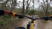
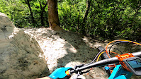
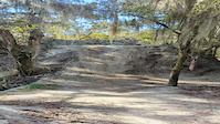
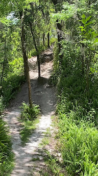
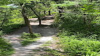
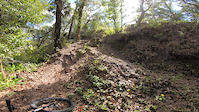
Photos of Lithia Mountain Bike
Videos of Lithia Mountain Bike

trail: Moonscape
0:07 |
98 |
Jan 18, 2025

trail: Moonscape
0:07 |
37 |
Jan 18, 2025
trail: Alafia Hills Trail pt1
0:11 |
137 |
Dec 17, 2022
trail: Mt. Boyette
0:23 |
142 |
Feb 21, 2022
trail: Alafia Hills Trail. pt 2
0:07 |
|
Jan 28, 2022
trail: Gatorback
0:10 |
346 |
Jun 28, 2021
trail: Gatorback
0:10 |
|
Jun 28, 2021
trail: Moonscape
0:08 |
273 |
Jan 1, 2021
Current Trail Warnings
| status | trail | date | condition | user | info |
|---|---|---|---|---|---|
| Lost Meadow | May 25, 2026 @ 4:30pm (America/New_York) May 25, 2026 | Unknown | JayAxObhh |
Recent Trail Reports
| status | trail | date | condition | info | user |
|---|---|---|---|---|---|
| Gatorback | Jun 4, 2026 @ 8:57am (America/Havana) Jun 4, 2026 | Ideal | rpenman | ||
| Buzzard's Bay | Jun 4, 2026 @ 8:57am (America/Havana) Jun 4, 2026 | Very Dry | rpenman | ||
| Magic Island | Jun 4, 2026 @ 8:57am (America/Havana) Jun 4, 2026 | Very Dry | rpenman | ||
| Twisted Sister | Jun 4, 2026 @ 8:57am (America/Havana) Jun 4, 2026 | Very Dry | rpenman | ||
| Thunder Ridge | Jun 4, 2026 @ 8:57am (America/Havana) Jun 4, 2026 | Ideal | rpenman | ||
| North Creek Trail | Jun 4, 2026 @ 8:57am (America/Havana) Jun 4, 2026 | Very Dry | rpenman | ||
| Spitfire | Jun 4, 2026 @ 8:57am (America/Havana) Jun 4, 2026 | Very Dry | rpenman | ||
| Berm | Jun 4, 2026 @ 8:57am (America/Havana) Jun 4, 2026 | Very Dry | rpenman | ||
| StarDust | Jun 4, 2026 @ 9:47am (America/Havana) Jun 4, 2026 | Very Dry | rpenman | ||
| Serpent | Jun 4, 2026 @ 9:47am (America/Havana) Jun 4, 2026 | Ideal | rpenman |
Activity Feed
| username | action | type | title | date |
|---|---|---|---|---|
| OzS8v0 | wishlist | route | activity #97225835 and 1 more | Jun 17, 2026 @ 7:10pm 1 day |
| ajveram | wishlist | region | activity #96774443 | Jun 11, 2026 @ 6:07pm Jun 11, 2026 |
| ajveram | wishlist | trail | activity #96774248 and 4 more | Jun 11, 2026 @ 6:04pm Jun 11, 2026 |
| danpardue | wishlist | route | activity #96359909 | Jun 6, 2026 @ 5:35am Jun 6, 2026 |
| rpenman | add | report | activity #96241874 and 20 more | Jun 4, 2026 @ 11:28am Jun 4, 2026 |
Recent Comments
| username | type | title | comment | date |
|---|---|---|---|---|
| trail | Large, 4 or 5 ft drop was added at top of... | May 9, 2026 @ 1:38pm May 9, 2026 | ||
| trail | Overgrown, unridable | Jan 7, 2026 @ 10:57am Jan 7, 2026 | ||
| trail | Overgrown, unridable | Jan 7, 2026 @ 10:56am Jan 7, 2026 | ||
| report | Ppl | Nov 6, 2025 @ 8:21am Nov 6, 2025 | ||
| trail | 💓💓 | Nov 2, 2025 @ 1:07pm Nov 2, 2025 |
Local Badges
-

Top 10 Trails291 awarded -

Descent 100k Badge2 awarded -

Big Ride 30k4,385 awarded -

Epic Ride 50k885 awarded -

Descent 10k Badge120 awarded -

Completionist41 awarded
Activity Type Stats
| activitytype | trails | distance | descent | descent distance | total vertical | rating | global rank | state rank | photos | reports | routes | ridelogs |
|---|---|---|---|---|---|---|---|---|---|---|---|---|
| Mountain Bike | 100 | 55 miles | 3,809 ft | 18 miles | 157 ft | #48 | #17 | 705 | 4,919 | 8 | 62,181 | |
| E-Bike | 98 | 52 miles | 3,622 ft | 17 miles | 157 ft | #364 | #698 | 4,782 | 2 | 6,454 | ||
| Horse | 13 | 16 miles | 1,191 ft | 6 miles | 128 ft | #827 | #595 | 127 | 793 | 7 | ||
| Hike | 60 | 44 miles | 2,375 ft | 14 miles | 167 ft | #2,358 | #942 | 20 | 4,524 | 575 | ||
| Trail Running | 60 | 44 miles | 2,375 ft | 14 miles | 167 ft | #4,350 | #1,330 | 4,523 | 357 |
Frequently Asked Questions About Lithia
▼
What are the best places to ride in Lithia?
Lithia has 4 areas to explore for mountain biking. The top rated areas are:
▼
What are the highest rated mountain biking trails in Lithia?
The highest rated mountain biking trails in Lithia are:
- Rollercoaster (4.7/5)
- Ridgeline (4.6/5)
- North Creek Trail (4.6/5)
- Berm (4.5/5)
- StarDust (4.5/5)
▼
What is the best time of the year to ride in Lithia?
Based on ride log data, the most popular months to ride in Lithia are:
- December (963 activities)
- February (944 activities)
- November (884 activities)
▼
Where can I park to ride in Lithia?
There are 8 parking locations listed in Lithia. The most popular parking spots are: View all parking and trailhead locations on the map to plan your visit.
Activities
Trails
- By brenthillier
 NSMBA TRAILFORKS & contributors
 - Admins: SWAMP
- #5919 - 23,579 views
- lithia activity log | embed map of Lithia mountain bike trails | lithia mountain biking points of interest
Downloading of trail gps tracks in kml & gpx formats is enabled for Lithia.
You must login to download files.