close
-
Layers w
- Weather Layers
- Pro
- Pro
- Pro
- Pro
- Pro
- Pro
- More Layers
- Pro
- Pro
- Pro
- Pro
-
Upgrade to

3D
Trail Conditions
- Unknown
- Snow Groomed
- Snow Packed
- Snow Covered
- Snow Cover Partial
- Freeze/thaw Cycle
- Icy
- Prevalent Mud
- Wet
- Variable
- Ideal
- Dry
- Very Dry
Trail Flow (Ridden Direction)
Trailforks scans users ridelogs to determine the most popular direction each trail is ridden. A good flowing trail network will have most trails flowing in a single direction according to their intension.
The colour categories are based on what percentage of riders are riding a trail in its intended direction.
The colour categories are based on what percentage of riders are riding a trail in its intended direction.
- > 96%
- > 90%
- > 80%
- > 70%
- > 50%
- < 50%
- bi-directional trail
- no data
Trail Last Ridden
Trailforks scans ridelogs to determine the last time a trail was ridden.
- < 2 days
- < 1 week
- < 2 weeks
- < 1 month
- < 6 months
- > 6 months
Trail Ridden Direction
The intended direction a trail should be ridden.
- Downhill Only
- Downhill Primary
- Both Directions
- Uphill Primary
- Uphill Only
- One Direction
Contribute Details
Colors indicate trail is missing specified detail.
- Description
- Photos
- Description & Photos
- Videos
Trail Popularity ?
Trailforks scans ridelogs to determine which trails are ridden the most in the last 9 months.
Trails are compared with nearby trails in the same city region with a possible 25 colour shades.
Think of this as a heatmap, more rides = more kinetic energy = warmer colors.
- most popular
- popular
- less popular
- not popular
ATV/ORV/OHV Filter
Max Vehicle Width
inches
US Cell Coverage
Legend

Radar Time
Activity Recordings
Trailforks uses anonymized public activity data.
?
Activity Recordings
Trailforks uses anonymized public activity data.
?
Personal Heatmap
▶
Activity Types
all
/
none
▶
Options
2
Date range
month
–
Winter Trails
Warning
A routing network for winter maps does not exist. Selecting trails using the winter trails layer has been disabled.
Missing Trails
Most Popular
Least Popular
Trails are colored based on popularity. The more popular a trail is, the more red. Less popular trails trend towards green.
Jump Magnitude Heatmap
Heatmap of where riders jump on trails. Zoom in to see individual jumps, click circles to view jump details.
BC Backroad Status
![map legend]()
Service Road Atlas is a free to use, community-driven service for viewing and creating reports on the numerous back-country service roads around B.C. and Alberta.

Slope Aspect
Direction the slope faces
Trails Deemphasized
Trails are shown in grey.
Only show trails with no bike usage.
Suggested Layers
Based on selected activity type
Save the current map location and zoom level as your default home location whenever this page is loaded.
Save
No description for Llangynog has been added yet!
Login or register to submit one.
This region uses the Uk/Euro style trail grading system.
Activities Click to view
- Mountain Bike
23 trails
- Gravel Bike
0 trails
- Adaptive Bike
0 trails
- Hike
3 trails
- Trail Running
3 trails
Region Details
- 3
- 4
- 8
- 5
Region Status
Open as of Apr 12, 2026Stats
- Avg Trail Rating
- Trails (view details)
- 22
- Trails Mountain Bike
- 23
- Trails E-Bike
- 2
- Trails Horse
- 2
- Trails Hike
- 3
- Trails Trail Running
- 3
- Trails Dirtbike/Moto
- 1
- Trails ATV/ORV/OHV
- 1
- Total Distance
- 6 miles
- Total Descent Distance
- 6 miles
- Total Descent
- 5,118 ft
- Total Vertical
- 908 ft
- Highest Trailhead
- 1,472 ft
- Reports
- 50
- Photos
- 1,335
- Ridden Counter
- 5,306
Articles
Video: Slapping Tech Turns & Big Air Lines at Revolution Bike Park in 'Gwyrdd'
Jun 21, 2022 from pinkbike.com
Martin Lebl's video makes us want to hop on the next plane to the UK.
Video: Women's Gravity Jam at Revolution Bike Park in 'Project Evolve'
May 25, 2022 from pinkbike.com
150 women and girls of all ages and abilities were out making progress.
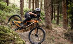
Photo Epic: Kade Edwards Let Loose on His Home Trails in Wales
Dec 17, 2020 from pinkbike.com
The Swiss Army knife of mountain biking.
Tahnée Seagrave Talks Protection And Rides the New Canyon Sender
Mar 15, 2020 from pinkbike.com
We get our best look at the new Sender in action to date as Tahnee discusses her relationship with D30.
Sub Regions
-
Revolution Bikepark
- 1
- 4
- 8
- 5
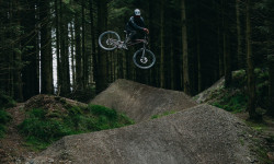
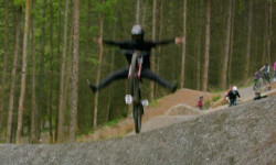
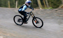
Popular Llangynog Mountain Biking Trails
Reddy McRedface Permanently Closed
• 95 ★ 4.3 • 2,503 ft • 0 ft • 531 •
Popular red difficulty closed mixed. This mountain bike primary trail can be used downhill only. It features berm, jump and other. On average it takes 4 minutes to complete this trail.
Red Downhill Permanently Closed
• 80 ★ 4.0 • 2,270 ft • 0 ft • 529 •
"A nice, wide man made section of trail starting with a flowy succession of fast berms leading into a variety of jumps and finishing into another fun berm section before landing back onto the second to last fire road." - Revolution Bike...
Ffar Side Permanently Closed
• 95 ★ 4.9 • 2,612 ft • 0 ft • 317 •
Starts with big, fast, surfaced tabletops and berms turning into a tighter, steeper section littered with drops before a high speed, flowing traverse across the hill and finally joining into the at the last fire road.
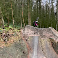
The Vision Line Permanently Closed
• 55 ★ 5.0 • 1,883 ft • 0 ft • 264 •
One of the largest, public accessible jump lines in the UK. The true definition of a "Pro Line".
Upper Ginger Bobcat Permanently Closed
• 100 ★ 0.0 • 915 ft • 0 ft • 259 •
Popular black difficulty closed singletrack. This mountain bike primary trail can be used downhill only. On average it takes 3 minutes to complete this trail.
Main Line Permanently Closed
• 70 ★ 4.0 • 4,616 ft • 0 ft • 219 •
"The "original" trail at Revolution - where it all began! A highly technical traditional downhill track with lots of roots, exposed rock and slatey corners. With so many options here line choice is key to mastering this track." -...
Bob Ffather Permanently Closed
• 90 ★ 0.0 • 643 ft • 0 ft • 81 •
Popular black difficulty closed mixed. This mountain bike primary trail can be used downhill only and has a moderate overall physical rating. It features berm, drop, gap jump and other. On average it takes 2 minutes to complete this trail.
Lower Ffar Side Permanently Closed
• 40 ★ 4.0 • 633 ft • 0 ft • 67 •
Moderately popular proline difficulty closed mixed. This mountain bike primary trail can be used downhill only. It features berm, jump and gap jump. On average it takes minutes to complete this trail.
Llangynog Mountain Bike Routes
16 miles • 3,380 ft • 1 • Point to Point •
Over the hill to Llandrillo and back
• 5 miles • 1,895 ft • 8 •
• 10 miles • 4,285 ft • 12 •
• 12 miles • 4,473 ft • 16 •
• 8 miles • 2,485 ft • 5 •
• 12 miles • 4,587 ft • 11 •
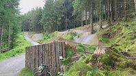
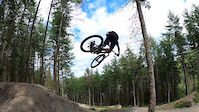
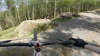
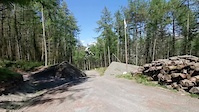
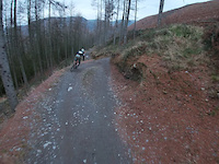
Photos of Llangynog Mountain Bike
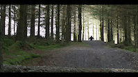
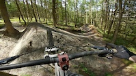
Videos of Llangynog Mountain Bike
trail: The Vision Line
0:29 |
105 |
Jun 5, 2022
trail: The Vision Line
0:44 |
55 |
Jan 24, 2022
trail: The Vision Line
0:52 |
117 |
Jul 12, 2021
trail: The Vision Line
0:28 |
67 |
May 30, 2021
trail: The Vision Line
0:13 |
108 |
May 30, 2021
trail: The Vision Line
0:08 |
142 |
May 30, 2021
trail: Reddy McRedface
0:20 |
123 |
Dec 6, 2020
trail: 50:01
0:54 |
209 |
Jan 5, 2020
Recent Trail Reports
| status | trail | date | condition | info | user |
|---|---|---|---|---|---|
| Reddy McRedface | Apr 12, 2026 @ 10:25am (Europe/Isle_of_Man) Apr 12, 2026 | Variable | weridemtbskillscoaching | ||
| Red Downhill | Apr 12, 2026 @ 10:25am (Europe/Isle_of_Man) Apr 12, 2026 | Variable | weridemtbskillscoaching | ||
| Upper Ginger Bobcat | Apr 12, 2026 @ 10:25am (Europe/Isle_of_Man) Apr 12, 2026 | Prevalent Mud | weridemtbskillscoaching | ||
| Main Line | Dec 20, 2025 @ 9:58am (Europe/London) Dec 20, 2025 | Variable | weridemtbskillscoaching | ||
| Bob Ffather | Oct 17, 2025 @ 10:16am (Europe/Isle_of_Man) Oct 17, 2025 | Variable | weridemtbskillscoaching | ||
| Ginger Bobcat | Oct 17, 2025 @ 10:16am (Europe/Isle_of_Man) Oct 17, 2025 | Ideal | weridemtbskillscoaching | ||
| Ffar Side | Oct 17, 2025 @ 10:16am (Europe/Isle_of_Man) Oct 17, 2025 | Ideal | weridemtbskillscoaching | ||
| Yr Oron | Jul 5, 2025 @ 2:03pm Jul 5, 2025 | Variable | rocktapa | ||
| Lower Ffar Side | Jun 28, 2025 @ 9:40am Jun 28, 2025 | Dry | weridemtbskillscoaching | ||
| The Vision Line | Mar 1, 2025 @ 10:17am Mar 1, 2025 | Variable | weridemtbskillscoaching |
Activity Feed
| username | action | type | title | date |
|---|---|---|---|---|
| trailforks | add | video | activity #95931540 | May 31, 2026 @ 6:00am May 31, 2026 |
| Dad82uk | wishlist | region | activity #93955052 | May 3, 2026 @ 9:18am May 3, 2026 |
| weridemtbskillscoaching | add | report | activity #92489138 and 2 more | Apr 12, 2026 @ 12:11pm Apr 12, 2026 |
| trailforks | add | video | activity #92136950 | Apr 7, 2026 @ 1:00pm Apr 7, 2026 |
| trailforks | add | video | activity #89335716 | Feb 22, 2026 @ 2:05am Feb 22, 2026 |
Recent Comments
| username | type | title | comment | date |
|---|---|---|---|---|
| trail | \m/ | Dec 7, 2020 @ 7:59pm Dec 7, 2020 | ||
| trail | Probably my favourite line at Revo. Tech,... | Oct 21, 2017 @ 2:45pm Oct 21, 2017 |
Local Badges
-

Epic Mountain Bike Climb 2k354 awarded -

Climbing 10k Badge21 awarded -

Mountain Biking 100k Badge0 awarded -

Epic Ride Descent 2k354 awarded -

Descent 10k Badge24 awarded -

Descent 100k Badge0 awarded
Bike & Skill Parks
| name | type | city | rating |
|---|---|---|---|
| Revolution Bikepark | bike park | Llangynog | |
| Freeride Dirt Jumps | skill park | Llangynog |
Activity Type Stats
| activitytype | trails | distance | descent | descent distance | total vertical | rating | global rank | state rank | photos | reports | routes | ridelogs |
|---|---|---|---|---|---|---|---|---|---|---|---|---|
| Mountain Bike | 23 | 6 miles | 5,118 ft | 6 miles | 909 ft | #3,334 | #110 | 1,335 | 50 | 1 | 2,808 | |
| E-Bike | 2 | 49 | 167 | |||||||||
| Horse | 2 | |||||||||||
| Hike | 3 | #9,568 | #301 | 48 | 144 | |||||||
| Trail Running | 3 | #9,080 | #288 | 47 | 10 | |||||||
| Dirtbike/Moto | 1 | |||||||||||
| ATV/ORV/OHV | 1 |
Frequently Asked Questions About Llangynog
▼
What are the best places to ride in Llangynog?
Llangynog has 1 areas to explore for mountain biking. The top rated areas are:
▼
What are the highest rated mountain biking trails in Llangynog?
The highest rated mountain biking trails in Llangynog are:
- Freeride (4.3/5)
- Yr Oron (0/5)
- Bridle Path Between Pistyll Rhaeadr To LLangynog (0/5)
- Moel Y Nant (0/5)
▼
What is the best time of the year to ride in Llangynog?
Based on ride log data, the most popular months to ride in Llangynog are:
- June (17 activities)
- October (16 activities)
- April (15 activities)
▼
Where can I park to ride in Llangynog?
There are 1 parking locations listed in Llangynog. The most popular parking spots are:
Activities
Trails
- By brenthillier
 NSMBA TRAILFORKS & contributors
 - Admins: apply
- #8405 - 3,920 views
- llangynog activity log | embed map of Llangynog mountain bike trails | llangynog mountain biking points of interest
Downloading of trail gps tracks in kml & gpx formats is enabled for Llangynog.
You must login to download files.