close
-
Layers w
- Weather Layers
- Pro
- Pro
- Pro
- Pro
- Pro
- Pro
- More Layers
- Pro
- Pro
- Pro
- Pro
-
Upgrade to

3D
Trail Conditions
- Unknown
- Snow Groomed
- Snow Packed
- Snow Covered
- Snow Cover Partial
- Freeze/thaw Cycle
- Icy
- Prevalent Mud
- Wet
- Variable
- Ideal
- Dry
- Very Dry
Trail Flow (Ridden Direction)
Trailforks scans users ridelogs to determine the most popular direction each trail is ridden. A good flowing trail network will have most trails flowing in a single direction according to their intension.
The colour categories are based on what percentage of riders are riding a trail in its intended direction.
The colour categories are based on what percentage of riders are riding a trail in its intended direction.
- > 96%
- > 90%
- > 80%
- > 70%
- > 50%
- < 50%
- bi-directional trail
- no data
Trail Last Ridden
Trailforks scans ridelogs to determine the last time a trail was ridden.
- < 2 days
- < 1 week
- < 2 weeks
- < 1 month
- < 6 months
- > 6 months
Trail Ridden Direction
The intended direction a trail should be ridden.
- Downhill Only
- Downhill Primary
- Both Directions
- Uphill Primary
- Uphill Only
- One Direction
Contribute Details
Colors indicate trail is missing specified detail.
- Description
- Photos
- Description & Photos
- Videos
Trail Popularity ?
Trailforks scans ridelogs to determine which trails are ridden the most in the last 9 months.
Trails are compared with nearby trails in the same city region with a possible 25 colour shades.
Think of this as a heatmap, more rides = more kinetic energy = warmer colors.
- most popular
- popular
- less popular
- not popular
ATV/ORV/OHV Filter
Max Vehicle Width
inches
US Cell Coverage
Legend

Radar Time
Activity Recordings
Trailforks uses anonymized public activity data.
?
Activity Recordings
Trailforks uses anonymized public activity data.
?
Personal Heatmap
▶
Activity Types
all
/
none
▶
Options
2
Date range
month
–
Winter Trails
Warning
A routing network for winter maps does not exist. Selecting trails using the winter trails layer has been disabled.
Missing Trails
Most Popular
Least Popular
Trails are colored based on popularity. The more popular a trail is, the more red. Less popular trails trend towards green.
Jump Magnitude Heatmap
Heatmap of where riders jump on trails. Zoom in to see individual jumps, click circles to view jump details.
BC Backroad Status
![map legend]()
Service Road Atlas is a free to use, community-driven service for viewing and creating reports on the numerous back-country service roads around B.C. and Alberta.

Slope Aspect
Direction the slope faces
Trails Deemphasized
Trails are shown in grey.
Only show trails with no bike usage.
Suggested Layers
Based on selected activity type
Save the current map location and zoom level as your default home location whenever this page is loaded.
Save
No description for Logan has been added yet!
Login or register to submit one.
Activities Click to view
- Mountain Bike
145 trails
- E-Bike
38 trails
- Gravel Bike
14 trails
- Adaptive Bike
0 trails
- Winter Fat Bike
0 trails
- Horse
49 trails
- Hike
167 trails
- Trail Running
165 trails
- Dirtbike/Moto
32 trails
- ATV/ORV/OHV
25 trails
- Downhill Ski
54 trails
- Nordic Ski
2 trails
Region Details
- 32
- 6
- 26
- 53
- 25
- 2
Region Status
Open as of 2 daysStats
- Avg Trail Rating
- Trails (view details)
- 228
- Trails Mountain Bike
- 145
- Trails E-Bike
- 38
- Trails Gravel Bike
- 14
- Trails Horse
- 49
- Trails Hike
- 167
- Trails Trail Running
- 165
- Trails Dirtbike/Moto
- 32
- Trails ATV/ORV/OHV
- 25
- Trails Snowmobile
- 2
- Trails Snowshoe
- 3
- Trails Downhill Ski
- 55
- Trails Nordic Ski
- 2
- Total Distance
- 429 miles
- Total Descent
- 101,575 ft
- Total Vertical
- 5,488 ft
- Highest Trailhead
- 9,933 ft
- Reports
- 1,295
- Photos
- 816
- Ridden Counter
- 23,424
Sub Regions
-
Beaver Mountain
- 2
- 4
- 2
-
Logan Canyon
- 6
- 32
- 17
- 1
-
Red spur camp
- 2
- 4
-
Right Hand Fork
- 4
- 3
- 4
- 1
Popular Logan Mountain Biking Trails
• 95 ★ 4.9 • 4 miles • 1,433 ft • 739 •
Amazing trail with a rough, steep and occasionally rocky upper section followed by a smooth, fast and flowy lower. This trail is mostly smooth until you get to the saddle. There are probably 12 water bars that make perfect senders on...
• 100 ★ 4.2 • 4 miles • 996 ft • 710 •
Great singletrack, some of the best Cache County has to offer. Fairly easy climb and minutes from town. The trail follows the dirt road and crosses it several times. The flow on this trail is excellent with a few opportunities to air...
• 100 ★ 4.5 • 3 miles • 1,163 ft • 562 •
Somewhat taxing climb, but all rideable. A bit rocky and narrow in places on the lower half of the trail. Upper half is manicured berms and more mellow in both grade and technical difficulty.
• 95 ★ 4.2 • 5 miles • 1,934 ft • 544 •
Great trail. Significant climb, but not over the top. Fast and flowy on the way downhill. Watch out for many other trail users on the weekends.
• 95 ★ 3.2 • 3 miles • 637 ft • 486 •
This trail is more technically challenging than aerobically challenging (in my opinion). I had to walk a couple sections but still had a ton of fun! It will improve over time as we get the dirt all packed down. Lots of fun rocks and roots.
• 100 ★ 4.9 • 3,629 ft • 0 ft • 452 •
This is a fast and flowy DH. The trail starts at the gravel road just a few yards from where the main trail kicks you up to the road. The contains berms and some rocky transitions. Even a gap jump and fun rocky feature.
• 85 ★ 4.0 • 4,313 ft • 108 ft • 404 •
Our own little Scotland, with sage brush. A rocky piece of single track that will take you from Stump Hollow to Peter Sink. Follow the cairns at the beginning while the trail is more difficult to see. After a while the trail becomes...
• 95 ★ 4.5 • 1,703 ft • 101 ft • 381 • • hike
This is the gravel section that is more common for campers and hikers to take. It is flat and easy and navigates through multiple camp areas.
Logan Mountain Bike Routes
★ 5.0 • 10 miles • 1,856 ft • 3 •
★ 4.0 • 27 miles • 5,033 ft • 7 • Loop •
Scenic pedal from the all new Comebacker resturaunt & bar to the absolute staple of Logan - The White...
6 miles • 449 ft • 1 •
15 miles • 2,406 ft • 3 •
Stump Hollow up to Sinks loop then out and back on Burnt and back home.
45 miles • 7,200 ft • 7 •
This is an outline for a Bikepacking adventure for a single night starting at beaver mountain, ending at...
9 miles • 3,315 ft • 1 •
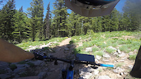
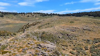
Photos of Logan Mountain Bike
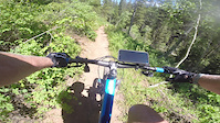
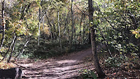
Videos of Logan Mountain Bike
trail: Stump Hollow (GWT)
17:16 |
64 |
Jul 6, 2023
trail: Stump Hollow (GWT)
11:29 |
18 |
Jul 6, 2023
trail: Green Canyon Trail
0:08 |
94 |
Oct 24, 2022
trail: Stump Hollow (GWT)
2:39 |
31 |
Jul 24, 2022
0:03 |
57 |
Jul 16, 2022
trail: Providence Canyon
0:02 |
139 |
Jul 15, 2022

trail: Providence Canyon
0:03 |
111 |
Jul 15, 2022
trail: Providence Canyon
0:08 |
93 |
Jun 26, 2022
Current Trail Warnings
| status | trail | date | condition | user | info |
|---|---|---|---|---|---|
| White Pine Creek | Jun 4, 2026 @ 11:32am (America/Denver) Jun 4, 2026 | Variable | marshdood | This is a horse or hiking trail, I rode... | |
| Hodges Canyon | May 29, 2026 @ 9:38pm (America/Denver) May 29, 2026 | Unknown | UtRoadie | Adaptive trail designation needs to be... |
Recent Trail Reports
| status | trail | date | condition | info | user |
|---|---|---|---|---|---|
| Richards Hollow | Jun 23, 2026 @ 11:51am (America/Boise) 2 days | Dry | usaf22raptor | ||
| Herd Hollow | Jun 23, 2026 @ 11:51am (America/Boise) 2 days | Dry | usaf22raptor | ||
| Logan Dry Canyon | Jun 10, 2026 @ 7:13pm (America/Denver) Jun 10, 2026 | Dry | sanchofula | ||
| Stump Hollow (GWT) | Jun 7, 2026 @ 7:10pm (America/Denver) Jun 7, 2026 | Unknown | usaf22raptor | ||
| Burnt Fork | May 25, 2026 @ 6:51am (America/Denver) May 25, 2026 | Snow Covered | kitebright | ||
| Wayne's World | May 19, 2026 @ 4:38pm (America/Boise) May 19, 2026 | Ideal | Nanajo | ||
| Wellsville Ridge | May 19, 2026 @ 4:38pm (America/Boise) May 19, 2026 | Ideal | Nanajo | ||
| Green Canyon | May 19, 2026 @ 12:42pm (America/Denver) May 19, 2026 | Ideal | gjhicken | ||
| Green Canyon | May 11, 2026 @ 6:35pm (America/Boise) May 11, 2026 | Ideal | Grimace1 | ||
| Sink Hollow | May 9, 2026 @ 12:58pm (America/Boise) May 9, 2026 | Snow Cover Partial | madhay |
National Scenic Trails & Official Routes
-
Bonneville Shoreline Trail
- Mountain Bike
- E-Bike
- Horse
- Hike
- Trail Running
- Snowshoe
- Nordic Ski
-
Great Western Trail
- Mountain Bike
- E-Bike
- Horse
- Hike
- Trail Running
- Dirtbike/Moto
- ATV/ORV/OHV


Activity Feed
| username | action | type | title | date |
|---|---|---|---|---|
| usaf22raptor | add | report | activity #97658338 and 1 more | Jun 23, 2026 @ 4:17pm 1 day |
| Kardbord | ridden | trail | activity #97646645 | Jun 23, 2026 @ 12:45pm 2 days |
| s2pace | wishlist | route | activity #97620871 | Jun 23, 2026 @ 6:00am 2 days |
| Kardbord | ridden | trail | activity #97608316 | Jun 22, 2026 @ 11:42pm 2 days |
| Kardbord | ridden | trail | activity #97608280 and 1 more | Jun 22, 2026 @ 11:41pm 2 days |
Recent Comments
| username | type | title | comment | date |
|---|---|---|---|---|
| trail | Still 20 plus trees down on lower part of this... | Jun 13, 2026 @ 8:50pm Jun 13, 2026 | ||
| trail | Rode it today. It was an adventure. A lot of... | May 29, 2026 @ 8:36pm May 29, 2026 | ||
| trail | We attempted to ride both bjorr trails... | May 24, 2026 @ 12:52pm May 24, 2026 | ||
| trail | Currently there is 30+ downed trees on a... | May 23, 2026 @ 2:43pm May 23, 2026 | ||
| trail | The map has the wrong line where the bike... | Apr 23, 2026 @ 11:38am Apr 23, 2026 |
Local Badges
-

10 Green Trails198 awarded -

10 Blue Trails250 awarded -

10 Black Trails25 awarded -

Epic Ride Climb 2k74 awarded -

Climbing 10k Badge177 awarded -

Climbing 100k Badge19 awarded
Bike & Skill Parks
| name | type | city | rating |
|---|---|---|---|
| Bridger Bike Park | skill park | Logan | |
| Bridgerland Bike Park | skill park | Logan |
Local Mountain Biking Directory
-
Cache Trails Alliance
-
SPEEDMountain
-
The Sportsman LTD
![The Sportsman LTD]()
-
Speed MountainBike Shop
-
Sunrise CycleryBike Shop
-
Recycled And New BicyclesBike Shop
Activity Type Stats
| activitytype | trails | distance | descent | descent distance | total vertical | rating | global rank | state rank | photos | reports | routes | ridelogs |
|---|---|---|---|---|---|---|---|---|---|---|---|---|
| Mountain Bike | 145 | 343 miles | 58,530 ft | 143 miles | 5,269 ft | #422 | #156 | 707 | 1,290 | 41 | 31,482 | |
| E-Bike | 38 | 122 miles | 19,596 ft | 52 miles | 4,961 ft | #1,181 | #828 | 812 | 3 | 1,824 | ||
| Gravel Bike | 14 | 32 miles | 3,888 ft | 14 miles | 3,734 ft | #291 | #912 | 128 | 2 | 23 | ||
| Horse | 49 | 141 miles | 24,541 ft | 57 miles | 4,974 ft | #118 | #380 | 16 | 385 | 1 | 9 | |
| Hike | 167 | 401 miles | 79,012 ft | 169 miles | 5,489 ft | #156 | #89 | 75 | 1,292 | 39 | 3,450 | |
| Trail Running | 165 | 401 miles | 78,766 ft | 168 miles | 5,489 ft | #188 | #83 | 11 | 1,291 | 42 | 2,813 | |
| Dirtbike/Moto | 32 | 119 miles | 18,153 ft | 52 miles | 4,879 ft | #200 | #116 | 7 | 372 | 1 | 60 | |
| ATV/ORV/OHV | 25 | 97 miles | 13,409 ft | 41 miles | 4,879 ft | #142 | #65 | 342 | 1 | 18 | ||
| Snowmobile | 2 | 2 miles | 246 ft | 3,009 ft | 614 ft | 2 | 1 | |||||
| Snowshoe | 3 | 4 miles | 344 ft | 1 mile | 4,823 ft | 1 | 21 | 71 | ||||
| Downhill Ski | 54 | 22 miles | 21,388 ft | 21 miles | 1,611 ft | #246 | #99 | 1,095 | ||||
| Nordic Ski | 2 | 3 miles | 249 ft | 1 mile | 259 ft | #773 | #296 | 2 | 797 |
Frequently Asked Questions About Logan
▼
What are the best places to ride in Logan?
Logan has 4 areas to explore for mountain biking. The top rated areas are:
▼
What are the highest rated mountain biking trails in Logan?
The highest rated mountain biking trails in Logan are:
- Stump Hollow (GWT) (4.7/5)
- Providence Alt (4.5/5)
- Providence Canyon (4.4/5)
- Green Canyon Trail (4.3/5)
- Spring Hollow (4.3/5)
▼
What is the best time of the year to ride in Logan?
Based on ride log data, the most popular months to ride in Logan are:
- July (580 activities)
- August (376 activities)
- June (346 activities)
▼
Where can I park to ride in Logan?
There are 49 parking locations listed in Logan. The most popular parking spots are: View all parking and trailhead locations on the map to plan your visit.
Activities
Trails
Points of Interest
- By chinwa & contributors
- Admins: apply
- #4456 - 30,044 views
- logan activity log | embed map of Logan mountain bike trails | logan mountain biking points of interest
Downloading of trail gps tracks in kml & gpx formats is enabled for Logan.
You must login to download files.