close
-
Layers w
- Weather Layers
- Pro
- Pro
- Pro
- Pro
- Pro
- Pro
- More Layers
- Pro
- Pro
- Pro
- Pro
-
Upgrade to

3D
Trail Conditions
- Unknown
- Snow Groomed
- Snow Packed
- Snow Covered
- Snow Cover Partial
- Freeze/thaw Cycle
- Icy
- Prevalent Mud
- Wet
- Variable
- Ideal
- Dry
- Very Dry
Trail Flow (Ridden Direction)
Trailforks scans users ridelogs to determine the most popular direction each trail is ridden. A good flowing trail network will have most trails flowing in a single direction according to their intension.
The colour categories are based on what percentage of riders are riding a trail in its intended direction.
The colour categories are based on what percentage of riders are riding a trail in its intended direction.
- > 96%
- > 90%
- > 80%
- > 70%
- > 50%
- < 50%
- bi-directional trail
- no data
Trail Last Ridden
Trailforks scans ridelogs to determine the last time a trail was ridden.
- < 2 days
- < 1 week
- < 2 weeks
- < 1 month
- < 6 months
- > 6 months
Trail Ridden Direction
The intended direction a trail should be ridden.
- Downhill Only
- Downhill Primary
- Both Directions
- Uphill Primary
- Uphill Only
- One Direction
Contribute Details
Colors indicate trail is missing specified detail.
- Description
- Photos
- Description & Photos
- Videos
Trail Popularity ?
Trailforks scans ridelogs to determine which trails are ridden the most in the last 9 months.
Trails are compared with nearby trails in the same city region with a possible 25 colour shades.
Think of this as a heatmap, more rides = more kinetic energy = warmer colors.
- most popular
- popular
- less popular
- not popular
ATV/ORV/OHV Filter
Max Vehicle Width
inches
US Cell Coverage
Legend

Radar Time
Activity Recordings
Trailforks uses anonymized public activity data.
?
Activity Recordings
Trailforks uses anonymized public activity data.
?
Personal Heatmap
▶
Activity Types
all
/
none
▶
Options
2
Date range
month
–
Winter Trails
Warning
A routing network for winter maps does not exist. Selecting trails using the winter trails layer has been disabled.
Missing Trails
Most Popular
Least Popular
Trails are colored based on popularity. The more popular a trail is, the more red. Less popular trails trend towards green.
Jump Magnitude Heatmap
Heatmap of where riders jump on trails. Zoom in to see individual jumps, click circles to view jump details.
BC Backroad Status
![map legend]()
Service Road Atlas is a free to use, community-driven service for viewing and creating reports on the numerous back-country service roads around B.C. and Alberta.

Slope Aspect
Direction the slope faces
Trails Deemphasized
Trails are shown in grey.
Only show trails with no bike usage.
Suggested Layers
Based on selected activity type
Save the current map location and zoom level as your default home location whenever this page is loaded.
SaveANNOUNCMENT! We are excited to announce that work will begin in 2024 on our new trails that were lost due to recent wildland fires. As soon as mother nature allows the amazing crew at Landmark Trailworks will be starting to dig new trails in our XC ski trail area. Until then, enjoy the few trails we have around Jasper Hill and Mimi Falls. Stay tuned, and check out Landmark Trailworks on their social media @landmarktrailworks
Activities Click to view
- Mountain Bike
78 trails
- E-Bike
11 trails
- Gravel Bike
0 trails
- Adaptive Bike
0 trails
- Winter Fat Bike
0 trails
- Hike
81 trails
- Trail Running
82 trails
- Snowshoe
11 trails
Region Details
- 22
- 17
- 30
- 8
- 1
Region Status
Caution as of May 23, 2026Stats
- Avg Trail Rating
- Trails (view details)
- 78
- Trails Mountain Bike
- 82
- Trails E-Bike
- 11
- Trails Hike
- 81
- Trails Trail Running
- 82
- Trails Snowshoe
- 11
- Total Distance
- 49 miles
- Total Descent
- 10,231 ft
- Total Vertical
- 1,243 ft
- Highest Trailhead
- 4,635 ft
- Reports
- 582
- Photos
- 128
- Ridden Counter
- 3,037
Sub Regions
-
Logan Lake
- 15
- 26
- 7
- 1
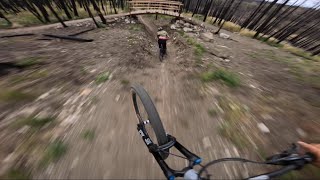
Popular Logan Lake Mountain Biking Trails
• 100 ★ 5.0 • 2,467 ft • 111 ft • 191 •
New trail to connect the new parking lot to the existing trail network.
• 95 ★ 5.0 • 4,557 ft • 183 ft • 150 •
Popular green difficulty singletrack. This mountain bike primary trail can be used both directions and has a moderate overall physical rating with a 183 ft blue climb. On average it takes 3 minutes to complete this trail.
• 100 ★ 4.8 • 2,943 ft • 15 ft • 142 •
New trail built in 2024 by Landmark Trailworks. Blue flow trail with amazing berms and tabletop jumps.
• 100 ★ 4.3 • 3,937 ft • 51 ft • 130 •
New blue flow trail built by Landmark Trailworks. flows right into this trail. Rides fast, lots of berms, jumps, and rollers.
• 95 ★ 5.0 • 4,770 ft • 19 ft • 119 •
New trail built by Landmark Trailworks in 2024. Its a black trail that starts at the , and makes its way down towards the campground. It starts off a bit technical, then works its way into more of a flow trail.
• 90 ★ 3.0 • 2 miles • 117 ft • 108 •
New trail built in 2024 by Landmark Trailworks. Easy flow trail that winds along the ridge, providing some great views of the valley below.
Photos of Logan Lake Mountain Bike
Videos of Logan Lake Mountain Bike
trail: Mullet's Revenge 2.0
2:26 |
151 |
Oct 9, 2022
trail: TreeFort
3:26 |
63 |
Oct 8, 2022
trail: Happy Camper Descent
0:39 |
18 |
Oct 8, 2022
trail: Quick
2:37 |
102 |
Mar 20, 2012
trail: Skid Mark
2:32 |
151 |
Sep 3, 2024 , Logan Lake

trail: Quickie
0:09 |
216 |
Jul 11, 2010
trail: Quickie
0:14 |
272 |
Mar 18, 2010

trail: Mimi Falls Trail
6:18 |
1219 |
May 21, 2018 , Logan Lake
Recent Trail Reports
| status | trail | date | condition | info | user |
|---|---|---|---|---|---|
| Happy Camper Descent | May 23, 2026 @ 1:21pm (America/Vancouver) May 23, 2026 | Dry | Swordfern | ||
| Meadow Walk | May 23, 2026 @ 1:21pm (America/Vancouver) May 23, 2026 | Dry | Swordfern | ||
| 3 Whoops | May 23, 2026 @ 1:21pm (America/Vancouver) May 23, 2026 | Dry | Swordfern | ||
| Hairy Ditch | May 23, 2026 @ 1:21pm (America/Vancouver) May 23, 2026 | Dry | Swordfern | ||
| Skid Mark | May 23, 2026 @ 1:21pm (America/Vancouver) May 23, 2026 | Dry | Swordfern | ||
| Fired Up | May 23, 2026 @ 1:21pm (America/Vancouver) May 23, 2026 | Dry | Swordfern | ||
| Cliffside | May 23, 2026 @ 1:21pm (America/Vancouver) May 23, 2026 | Dry | Swordfern | ||
| TreeFort | May 23, 2026 @ 1:21pm (America/Vancouver) May 23, 2026 | Dry | Swordfern | ||
| Midway Climb | May 23, 2026 @ 1:21pm (America/Vancouver) May 23, 2026 | Dry | Swordfern | ||
| Reach Around | May 17, 2026 @ 3:22pm (America/Vancouver) May 17, 2026 | Ideal | konakurt |
Activity Feed
| username | action | type | title | date |
|---|---|---|---|---|
| jdhansen63 | wishlist | region | activity #96423971 | Jun 6, 2026 @ 7:10pm Jun 6, 2026 |
| ondrejkvetko | ridden | trail | activity #96133266 | Jun 2, 2026 @ 8:35pm Jun 2, 2026 |
| Swordfern | vote | trail | activity #95911828 and 8 more | May 30, 2026 @ 11:34pm May 30, 2026 |
| Swordfern | add | report | activity #95368349 and 11 more | May 23, 2026 @ 5:27pm May 23, 2026 |
| konakurt | add | report | activity #94944785 | May 17, 2026 @ 3:22pm May 17, 2026 |
Recent Comments
| username | type | title | comment | date |
|---|---|---|---|---|
| trail | This trail appears to have disappeared into... | May 11, 2025 @ 4:19pm May 11, 2025 | ||
| trail | Makes a great climb route as well! | May 11, 2025 @ 9:36am May 11, 2025 | ||
| report | Freshly raked… | May 1, 2025 @ 3:28pm May 1, 2025 | ||
| report | Awesome thanks for all the hard work | Sep 16, 2024 @ 4:27pm Sep 16, 2024 | ||
| trail | A really fast and fun dark blue flow trail.... | Aug 19, 2024 @ 9:03pm Aug 19, 2024 |
Local Badges
-

10 Green Trails14 awarded -

10 Blue Trails31 awarded -

Epic Ride Climb 2k1 awarded -

Climbing 10k Badge4 awarded -

Climbing 100k Badge0 awarded -

Epic Ride Descent 2k1 awarded
Bike & Skill Parks
| name | type | city | rating |
|---|---|---|---|
| Logan Lake Bike Park | skill park | Logan Lake |
Activity Type Stats
| activitytype | trails | distance | descent | descent distance | total vertical | rating | global rank | state rank | photos | reports | routes | ridelogs |
|---|---|---|---|---|---|---|---|---|---|---|---|---|
| Mountain Bike | 78 | 49 miles | 10,230 ft | 23 miles | 1,243 ft | #2,399 | #75 | 111 | 598 | 1,439 | ||
| E-Bike | 11 | 2 miles | 696 ft | 1 mile | 407 ft | #6,688 | #118 | 524 | 2 | 91 | ||
| Hike | 81 | 49 miles | 9,925 ft | 23 miles | 1,243 ft | #2,308 | #82 | 16 | 597 | 2 | 176 | |
| Trail Running | 82 | 49 miles | 10,230 ft | 23 miles | 1,243 ft | #3,600 | #90 | 598 | 2 | 31 | ||
| Snowshoe | 11 | 3 miles | 804 ft | 2 miles | 988 ft | #1,184 | #65 | 25 | 1 | 53 |
Frequently Asked Questions About Logan Lake
▼
What are the best places to ride in Logan Lake?
Logan Lake has 1 areas to explore for mountain biking. The top rated areas are:
▼
What are the highest rated mountain biking trails in Logan Lake?
The highest rated mountain biking trails in Logan Lake are:
- Cliffside (4.4/5)
- Fired Up (4.3/5)
- Midway Climb (4.3/5)
- Skid Mark (4.3/5)
- Fairway (4.2/5)
▼
What is the best time of the year to ride in Logan Lake?
Based on ride log data, the most popular months to ride in Logan Lake are:
- July (88 activities)
- June (67 activities)
- September (67 activities)
▼
Where can I park to ride in Logan Lake?
There are 3 parking locations listed in Logan Lake. The most popular parking spots are: View all parking and trailhead locations on the map to plan your visit.
Activities
Trails
Points of Interest
- By jondurham & contributors
- Admins: BCBR, TrailsBC, BCORMA, DSBC, wheelmaniac3, bcpunk, canadianenduro, SlinkySammy
- #14335 - 9,489 views
- logan lake activity log | embed map of Logan Lake mountain bike trails | logan lake mountain biking points of interest polygons
Downloading of trail gps tracks in kml & gpx formats is enabled for Logan Lake.
You must login to download files.