close
-
Layers w
- Weather Layers
- Pro
- Pro
- Pro
- Pro
- Pro
- Pro
- More Layers
- Pro
- Pro
- Pro
- Pro
-
Upgrade to

3D
Trail Conditions
- Unknown
- Snow Groomed
- Snow Packed
- Snow Covered
- Snow Cover Partial
- Freeze/thaw Cycle
- Icy
- Prevalent Mud
- Wet
- Variable
- Ideal
- Dry
- Very Dry
Trail Flow (Ridden Direction)
Trailforks scans users ridelogs to determine the most popular direction each trail is ridden. A good flowing trail network will have most trails flowing in a single direction according to their intension.
The colour categories are based on what percentage of riders are riding a trail in its intended direction.
The colour categories are based on what percentage of riders are riding a trail in its intended direction.
- > 96%
- > 90%
- > 80%
- > 70%
- > 50%
- < 50%
- bi-directional trail
- no data
Trail Last Ridden
Trailforks scans ridelogs to determine the last time a trail was ridden.
- < 2 days
- < 1 week
- < 2 weeks
- < 1 month
- < 6 months
- > 6 months
Trail Ridden Direction
The intended direction a trail should be ridden.
- Downhill Only
- Downhill Primary
- Both Directions
- Uphill Primary
- Uphill Only
- One Direction
Contribute Details
Colors indicate trail is missing specified detail.
- Description
- Photos
- Description & Photos
- Videos
Trail Popularity ?
Trailforks scans ridelogs to determine which trails are ridden the most in the last 9 months.
Trails are compared with nearby trails in the same city region with a possible 25 colour shades.
Think of this as a heatmap, more rides = more kinetic energy = warmer colors.
- most popular
- popular
- less popular
- not popular
ATV/ORV/OHV Filter
Max Vehicle Width
inches
US Cell Coverage
Legend

Radar Time
Activity Recordings
Trailforks uses anonymized public activity data.
?
Activity Recordings
Trailforks uses anonymized public activity data.
?
Personal Heatmap
▶
Activity Types
all
/
none
▶
Options
2
Date range
month
–
Winter Trails
Warning
A routing network for winter maps does not exist. Selecting trails using the winter trails layer has been disabled.
Missing Trails
Most Popular
Least Popular
Trails are colored based on popularity. The more popular a trail is, the more red. Less popular trails trend towards green.
Jump Magnitude Heatmap
Heatmap of where riders jump on trails. Zoom in to see individual jumps, click circles to view jump details.
BC Backroad Status
![map legend]()
Service Road Atlas is a free to use, community-driven service for viewing and creating reports on the numerous back-country service roads around B.C. and Alberta.

Slope Aspect
Direction the slope faces
Trails Deemphasized
Trails are shown in grey.
Only show trails with no bike usage.
Suggested Layers
Based on selected activity type
Save the current map location and zoom level as your default home location whenever this page is loaded.
Save
No description for Logandale has been added yet!
Login or register to submit one.
Activities Click to view
- Mountain Bike
19 trails
- E-Bike
17 trails
- Adaptive Bike
0 trails
- Hike
22 trails
- Trail Running
20 trails
Region Details
- 5
- 11
- 3
Region Status
Open as of Jun 7, 2026Stats
- Avg Trail Rating
- Trails (view details)
- 23
- Trails Mountain Bike
- 19
- Trails E-Bike
- 17
- Trails Hike
- 22
- Trails Trail Running
- 20
- Trails Observed Trials
- 1
- Total Distance
- 25 miles
- Total Descent Distance
- 10 miles
- Total Descent
- 2,511 ft
- Total Vertical
- 1,178 ft
- Highest Trailhead
- 2,381 ft
- Reports
- 650
- Photos
- 197
- Ridden Counter
- 2,145
Sub Regions
-
Jackrabbit Trails
- 5
- 9
- 2
Popular Logandale Mountain Biking Trails
• 95 ★ 4.7 • 1 mile • 98 ft • 267 •
Highly rated popular green difficulty family friendly singletrack. This mountain bike primary trail can be used both directions and has a easy overall physical rating with a 98 ft green climb. Trail visibility is always easy to follow. On average it takes 7 minutes to complete this trail.
• 90 ★ 5.0 • 3,117 ft • 128 ft • 209 •
Popular blue difficulty singletrack. This mountain bike primary trail can be used both directions and has a moderate overall physical rating. It features jump. On average it takes 6 minutes to complete this trail.
• 90 ★ 4.9 • 4,406 ft • 73 ft • 133 •
Highly rated popular blue difficulty singletrack. This mountain bike primary trail can be used downhill primary and has a moderate overall physical rating with a 73 ft green climb. It features gap jump. On average it takes 8 minutes to complete this trail.
• 85 ★ 5.0 • 2,083 ft • 12 ft • 128 •
Connects the to the highway and other trails to the north of the highway.
• 80 ★ 5.0 • 4,675 ft • 208 ft • 117 •
Popular blue difficulty singletrack. This mountain bike primary trail can be used both directions and has a hard overall physical rating. On average it takes 11 minutes to complete this trail.
• 70 ★ 4.4 • 1,690 ft • 4 ft • 117 •
Popular black diamond difficulty singletrack. This mountain bike primary trail can be used downhill only and has a moderate overall physical rating. It features drop, rock face and rock garden. On average it takes 3 minutes to complete this trail.
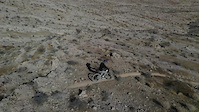
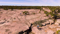
Photos of Logandale Mountain Bike
Videos of Logandale Mountain Bike
trail: Black Lunge
0:23 |
148 |
Jan 26, 2021

trail: Warm Up Loop
0:54 |
28 |
Jan 26, 2021
trail: Divide
0:22 |
102 |
Jan 21, 2021
trail: Ibis
4:09 |
133 |
Feb 29, 2016
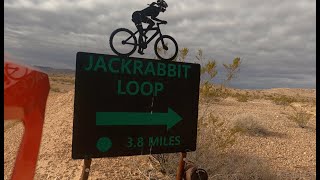
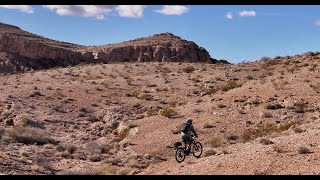
trail: Jackrabbit Loop Trail
6:16 |
87 |
Feb 26, 2025 , Logandale
trail: Jackrabbit Trail
8:03 |
53 |
Feb 26, 2025 , Logandale
youtuber
![Stop Here on your Way to Las Vegas |...]()
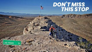
trail: Stars and Stripes
4:44 |
205 |
Mar 8, 2024 , Logandale
youtuber
![Riding Jackrabbits on the way to Las Vegas! |...]()
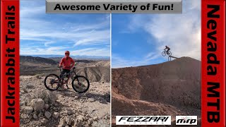
trail: Mitch's Trail
22:26 |
118 |
Feb 23, 2024 , Logandale
Recent Trail Reports
| status | trail | date | condition | info | user |
|---|---|---|---|---|---|
| Jack's Reward | May 20, 2026 @ 9:49am (America/Los_Angeles) May 20, 2026 | Dry | watusi512 | ||
| Conquer | May 18, 2026 @ 6:44am (America/Los_Angeles) May 18, 2026 | Dry | watusi512 | ||
| Stars and Stripes | May 18, 2026 @ 6:44am (America/Los_Angeles) May 18, 2026 | Dry | watusi512 | ||
| Sidewinder | May 18, 2026 @ 6:44am (America/Los_Angeles) May 18, 2026 | Dry | watusi512 | ||
| Divide | May 18, 2026 @ 6:44am (America/Los_Angeles) May 18, 2026 | Dry | watusi512 | ||
| Grindstone - Swamp Jump Bypass | May 6, 2026 @ 6:32am (America/Los_Angeles) May 6, 2026 | Ideal | watusi512 | ||
| Rim Trail | May 6, 2026 @ 6:32am (America/Los_Angeles) May 6, 2026 | Ideal | watusi512 | ||
| Lookout Lollipop | May 6, 2026 @ 6:32am (America/Los_Angeles) May 6, 2026 | Ideal | watusi512 | ||
| Lookout Trail | May 6, 2026 @ 6:32am (America/Los_Angeles) May 6, 2026 | Ideal | watusi512 | ||
| Jackrabbit Trail | May 6, 2026 @ 6:32am (America/Los_Angeles) May 6, 2026 | Ideal | watusi512 |
Activity Feed
| username | action | type | title | date |
|---|---|---|---|---|
| hardyr4 | add | photo | activity #95680174 | May 27, 2026 @ 7:18pm May 27, 2026 |
| watusi512 | add | report | activity #95115197 | May 20, 2026 @ 9:50am May 20, 2026 |
| watusi512 | add | photo | activity #95115058 and 1 more | May 20, 2026 @ 9:48am May 20, 2026 |
| watusi512 | vote | trail | activity #95114971 | May 20, 2026 @ 9:46am May 20, 2026 |
| watusi512 | add | photo | activity #95114216 and 9 more | May 20, 2026 @ 9:36am May 20, 2026 |
Recent Comments
| username | type | title | comment | date |
|---|---|---|---|---|
| trail | Rim trail to grindstone nice loop add on to... | May 4, 2026 @ 4:29pm May 4, 2026 | ||
| trail | Closed for repairs as of 5/4/2026. | May 4, 2026 @ 4:27pm May 4, 2026 | ||
| trail | Ride it CCW, way more flowy. Low bar on... | May 4, 2026 @ 4:25pm May 4, 2026 | ||
| trail | Rode it CW and CCW. CCW is way more fun. | May 4, 2026 @ 2:02pm May 4, 2026 | ||
| trail | Clearly marked, well maintained. Silly fun. | Apr 25, 2026 @ 8:30pm Apr 25, 2026 |
Local Badges
-

Epic Ride Climb 2k0 awarded -

Climbing 10k Badge2 awarded -

Climbing 100k Badge0 awarded -

Epic Ride Descent 2k0 awarded -

Descent 10k Badge2 awarded -

Descent 100k Badge0 awarded
Activity Type Stats
| activitytype | trails | distance | descent | descent distance | total vertical | rating | global rank | state rank | photos | reports | routes | ridelogs |
|---|---|---|---|---|---|---|---|---|---|---|---|---|
| Mountain Bike | 19 | 17 miles | 1,975 ft | 8 miles | 525 ft | #3,904 | #1,309 | 139 | 650 | 2,426 | ||
| E-Bike | 17 | 16 miles | 1,696 ft | 7 miles | 479 ft | #537 | #728 | 24 | 638 | 308 | ||
| Hike | 22 | 21 miles | 2,238 ft | 8 miles | 1,178 ft | #3,999 | #1,413 | 34 | 643 | 348 | ||
| Trail Running | 20 | 17 miles | 1,808 ft | 7 miles | 1,132 ft | #8,176 | #2,724 | 643 | 24 | |||
| Observed Trials | 1 | 3,054 ft | 82 ft | 1,188 ft | 85 ft |
Frequently Asked Questions About Logandale
▼
What are the best places to ride in Logandale?
Logandale has 1 areas to explore for mountain biking. The top rated areas are:
▼
What are the highest rated mountain biking trails in Logandale?
The highest rated mountain biking trails in Logandale are:
- Grindstone - Swamp Jump Bypass (4.4/5)
- Lookout Trail (4.3/5)
- Jackrabbit Trail (4.3/5)
- Warm Up Loop (4.3/5)
- Jackrabbit Loop Trail (4.3/5)
▼
What is the best time of the year to ride in Logandale?
Based on ride log data, the most popular months to ride in Logandale are:
- February (36 activities)
- November (24 activities)
- October (23 activities)
▼
Where can I park to ride in Logandale?
There are 6 parking locations listed in Logandale. The most popular parking spots are: View all parking and trailhead locations on the map to plan your visit.
Activities
Trails
Points of Interest
- By whipple5
 & contributors
 - Admins: SNMBA, JonnieDangerously, whipple5, BLM NV GBNM
- #28535 - 5,915 views
- logandale activity log | embed map of Logandale mountain bike trails | logandale mountain biking points of interest
Downloading of trail gps tracks in kml & gpx formats is enabled for Logandale.
You must login to download files.