close
-
Layers w
- Weather Layers
- Pro
- Pro
- Pro
- Pro
- Pro
- Pro
- More Layers
- Pro
- Pro
- Pro
- Pro
-
Upgrade to

3D
Trail Conditions
- Unknown
- Snow Groomed
- Snow Packed
- Snow Covered
- Snow Cover Partial
- Freeze/thaw Cycle
- Icy
- Prevalent Mud
- Wet
- Variable
- Ideal
- Dry
- Very Dry
Trail Flow (Ridden Direction)
Trailforks scans users ridelogs to determine the most popular direction each trail is ridden. A good flowing trail network will have most trails flowing in a single direction according to their intension.
The colour categories are based on what percentage of riders are riding a trail in its intended direction.
The colour categories are based on what percentage of riders are riding a trail in its intended direction.
- > 96%
- > 90%
- > 80%
- > 70%
- > 50%
- < 50%
- bi-directional trail
- no data
Trail Last Ridden
Trailforks scans ridelogs to determine the last time a trail was ridden.
- < 2 days
- < 1 week
- < 2 weeks
- < 1 month
- < 6 months
- > 6 months
Trail Ridden Direction
The intended direction a trail should be ridden.
- Downhill Only
- Downhill Primary
- Both Directions
- Uphill Primary
- Uphill Only
- One Direction
Contribute Details
Colors indicate trail is missing specified detail.
- Description
- Photos
- Description & Photos
- Videos
Trail Popularity ?
Trailforks scans ridelogs to determine which trails are ridden the most in the last 9 months.
Trails are compared with nearby trails in the same city region with a possible 25 colour shades.
Think of this as a heatmap, more rides = more kinetic energy = warmer colors.
- most popular
- popular
- less popular
- not popular
ATV/ORV/OHV Filter
Max Vehicle Width
inches
US Cell Coverage
Legend

Radar Time
Activity Recordings
Trailforks uses anonymized public activity data.
?
Activity Recordings
Trailforks uses anonymized public activity data.
?
Personal Heatmap
▶
Activity Types
all
/
none
▶
Options
2
Date range
month
–
Winter Trails
Warning
A routing network for winter maps does not exist. Selecting trails using the winter trails layer has been disabled.
Missing Trails
Most Popular
Least Popular
Trails are colored based on popularity. The more popular a trail is, the more red. Less popular trails trend towards green.
Jump Magnitude Heatmap
Heatmap of where riders jump on trails. Zoom in to see individual jumps, click circles to view jump details.
BC Backroad Status
![map legend]()
Service Road Atlas is a free to use, community-driven service for viewing and creating reports on the numerous back-country service roads around B.C. and Alberta.

Slope Aspect
Direction the slope faces
Trails Deemphasized
Trails are shown in grey.
Only show trails with no bike usage.
Suggested Layers
Based on selected activity type
Save the current map location and zoom level as your default home location whenever this page is loaded.
SaveLogroño es una ciudad y municipio situado en el norte de España, capital de la comunidad autónoma de La Rioja. Con 152 485 habitantes (2020),5 también es su localidad de mayor población, concentrando casi la mitad del total, así como su centro económico, cultural y de servicios.
Siendo atravesada en su parte norte por el río Ebro, Logroño ha sido históricamente un lugar de paso y cruce de caminos, tales como el Camino de Santiago, y de fronteras, disputada entre los antiguos reinos hispanos de la península ibérica durante la Edad Media. En el último siglo, la ciudad ha experimentado un crecimiento demográfico lento pero significativo respecto a las poblaciones cercanas, provocado principalmente por los movimientos migratorios desde otras comarcas de la provincia. Fue en 1997 la primera Ciudad Comercial de España, así como la primera Capital Gastronómica Española en 2012 y también Ciudad Europea del Deporte en 2014.
Siendo atravesada en su parte norte por el río Ebro, Logroño ha sido históricamente un lugar de paso y cruce de caminos, tales como el Camino de Santiago, y de fronteras, disputada entre los antiguos reinos hispanos de la península ibérica durante la Edad Media. En el último siglo, la ciudad ha experimentado un crecimiento demográfico lento pero significativo respecto a las poblaciones cercanas, provocado principalmente por los movimientos migratorios desde otras comarcas de la provincia. Fue en 1997 la primera Ciudad Comercial de España, así como la primera Capital Gastronómica Española en 2012 y también Ciudad Europea del Deporte en 2014.
source: Ayuntamiento Logroño
This region uses the Uk/Euro style trail grading system.
Activities Click to view
- Mountain Bike
1,402 trails
- E-Bike
1,389 trails
- Gravel Bike
4 trails
- Adaptive Bike
0 trails
- Horse
167 trails
- Hike
1,437 trails
- Trail Running
1,424 trails
- ATV/ORV/OHV
5 trails
Region Details
- 597
- 108
- 383
- 181
- 16
Region Status
Open as of 2 daysStats
- Avg Trail Rating
- Trails (view details)
- 1,332
- Trails Mountain Bike
- 1,402
- Trails E-Bike
- 1,389
- Trails Gravel Bike
- 4
- Trails Horse
- 167
- Trails Hike
- 1,437
- Trails Trail Running
- 1,424
- Trails Dirtbike/Moto
- 3
- Trails ATV/ORV/OHV
- 5
- Trails Nordic Ski
- 1
- Total Distance
- 1,530 miles
- Total Descent Distance
- 716 miles
- Total Descent
- 293,552 ft
- Total Vertical
- 5,838 ft
- Highest Trailhead
- 6,984 ft
- Reports
- 2,272
- Photos
- 597
- Ridden Counter
- 27,985
Sub Regions
-
Anguiano
-
Cervera-Aguilar del Rio Alhama
- 4
- 14
- 12
- 1
-
Dehesa de Hornos
- 1
- 1
-
Dehesa De Navarrete
- 5
- 15
- 2
-
El Cortijo
- 25
- 39
- 2
-
Igea
- 9
- 9
-
Jubera Valley - Territorio Jubera
- 42
- 17
-
La Grajera
- 9
- 14
- 11
- 2
-
Laguna De Cameros
- 3
- 4
- 2
-
Las Viniegras
- 1
- 19
- 10
- 2
-
Monkal
- 27
- 49
- 21
- 6
-
Nieva de Cameros
- 7
- 47
- 32
-
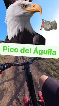
Pico del Águila
- 7
- 28
- 18
- 4
-
San Román De Cameros
- 1
- 28
- 7
-
Sierra Cantabria
- 4
- 13
- 7
-
Sierra Cebollera
- 2
- 7
- 2
-
Torrecilla en Cameros
- 7
- 20
- 17
-
Viguera
- 3
- 19
- 1
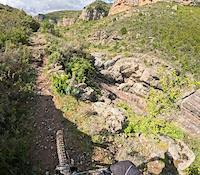
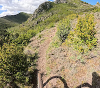
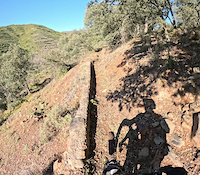
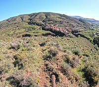
Popular Logroño Mountain Biking Trails
• 100 ★ 3.5 • 2,060 ft • 3 ft • 170 •
Popular green difficulty singletrack. This multi-use trail can be used both directions and has a moderate overall physical rating with a 3 ft green climb. Trail visibility is always easy to follow. On average it takes 1 minutes to complete this trail.
• 100 ★ 4.3 • 2,569 ft • 312 ft • 141 •
Sendero con muchas zetas muy exigente físicamente pero que sirve de enlace para llegar antes arriba. Va paralelo al cortafuegos y pasa por una zona de pinar muy bonita. sobre todo suele ser utilizada por E-Bikes
• 100 ★ 4.7 • 2,457 ft • 0 ft • 132 •
Bonita y rápida senda próxima al campo de golf de Sojuela
Logroño Mountain Bike Routes
★ 5.0 • 20 miles • 4,244 ft • 15 • Point to Point •
Guapísima y exigente la ruta endurera, por terreno duro y trabajoso, dureza que se compensa con un...
★ 4.0 • 31 miles • 3,728 ft • 21 • Loop •
18/05/2025 (XCM) | LOGROÑO 49,64 km & 1.105 m+ La última etapa será por Moncalvillo con 49...
★ 5.0 • 9 miles • 1,470 ft • 5 • Point to Point •
La Vía Romana del Iregua es un camino que, según algunos estudios, utilizaron los romanos para comunicar...
★ 5.0 • 19 miles • 3,341 ft • 10 • Loop •
Para mí, una de las mejores rutas de sendero que he realizado hasta la fecha, algún tramo de echar pie...
★ 3.0 • 48 miles • 5,366 ft • 25 • Loop •
78,56 km & 1.523 m+ Etapa de 83 kilómetros con salida y llegada desde el Palacio de Deportes de La...
Photos of Logroño Mountain Bike
Videos of Logroño Mountain Bike
trail: Neo Subida
0:24 |
10 |
Dec 30, 2024
trail: Paralela
0:24 |
20 |
Dec 16, 2024
trail: Cara Oeste
0:24 |
6 |
Dec 16, 2024
trail: Stone Flow de Aristóteles
0:52 |
20 |
May 3, 2024
trail: Barranco de San Martín
0:37 |
21 |
May 3, 2024
trail: San Bartolomé Inferior
0:43 |
3 |
May 3, 2024
trail: Cabezo del Escurial
0:25 |
18 |
May 3, 2024
trail: Los Brujales
0:03 |
28 |
May 3, 2024
Current Trail Warnings
| status | trail | date | condition | user | info |
|---|---|---|---|---|---|
| Los Caballos | Jun 21, 2026 @ 5:24pm (Europe/Madrid) 2 days | Dry | alivemountain TFSPAIN | Cerrado por la vegetacion | |
| Hermedaña | Jun 12, 2026 @ 11:29pm (Europe/Madrid) Jun 12, 2026 | Dry | raullopezch TFSPAIN | Al menos la parte final del sendero ha... | |
| Druida | Jun 12, 2026 @ 6:59am (Europe/Madrid) Jun 11, 2026 | Variable | raullopezch TFSPAIN | La senda en si está perfecta, pero han... |
Recent Trail Reports
| status | trail | date | condition | info | user |
|---|---|---|---|---|---|
| Vulcano | Jun 12, 2026 @ 6:59am (Europe/Madrid) Jun 11, 2026 | Dry | raullopezch TFSPAIN | ||
| Vulcano | Jun 12, 2026 @ 6:59am (Europe/Madrid) Jun 11, 2026 | Dry | raullopezch TFSPAIN | ||
| Fuego | Jun 12, 2026 @ 6:59am (Europe/Madrid) Jun 11, 2026 | Dry | raullopezch TFSPAIN | ||
| Regadera | Jun 12, 2026 @ 6:59am (Europe/Madrid) Jun 11, 2026 | Ideal | raullopezch TFSPAIN | ||
| Hermedaña | Jun 12, 2026 @ 6:59am (Europe/Madrid) Jun 11, 2026 | Unknown | raullopezch TFSPAIN | ||
| Oscura | Jun 12, 2026 @ 6:59am (Europe/Madrid) Jun 11, 2026 | Ideal | raullopezch TFSPAIN | ||
| Mirador | Jun 12, 2026 @ 6:59am (Europe/Madrid) Jun 11, 2026 | Dry | raullopezch TFSPAIN | ||
| Acceso Mirador | Jun 12, 2026 @ 6:59am (Europe/Madrid) Jun 11, 2026 | Ideal | raullopezch TFSPAIN | ||
| Lobo | Jun 12, 2026 @ 6:59am (Europe/Madrid) Jun 11, 2026 | Dry | raullopezch TFSPAIN | ||
| Dolorosa | Jun 12, 2026 @ 6:59am (Europe/Madrid) Jun 11, 2026 | Ideal | raullopezch TFSPAIN |
National Scenic Trails & Official Routes
-
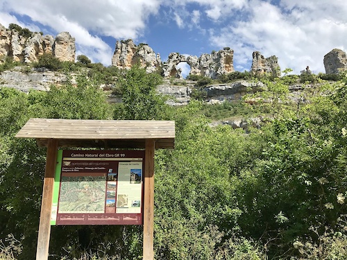
GR 99 Camino Natural del Ebro
- Mountain Bike
- E-Bike
- Horse
- Hike
- Trail Running
-
GR-65 Camino de Santiago
- Mountain Bike
- E-Bike
- Hike
- Trail Running
Activity Feed
| username | action | type | title | date |
|---|---|---|---|---|
| alivemountain | comment | trail | activity #97487488 | Jun 21, 2026 @ 8:26am 2 days |
| alivemountain | add | report | activity #97487358 | Jun 21, 2026 @ 8:25am 2 days |
| DiegoTorrecilla | comment | trail | activity #97379605 | Jun 20, 2026 @ 4:02am 3 days |
| raullopezch | add | report | activity #96826965 and 17 more | Jun 12, 2026 @ 2:05pm Jun 12, 2026 |
| zBsi5C | comment | trail | activity #96541579 | Jun 8, 2026 @ 8:31am Jun 8, 2026 |
Recent Comments
| username | type | title | comment | date |
|---|---|---|---|---|
| trail | En estos casos lo mejor es poner un reporte... | Jun 21, 2026 @ 8:26am 2 days | ||
| trail | Completamente cerrado por la vegetación. Me... | Jun 20, 2026 @ 4:02am 3 days | ||
| trail | La salida está cerrada | Jun 8, 2026 @ 8:31am Jun 8, 2026 | ||
| trail | Ha mejorado el tema de las piedras y el agua,... | May 31, 2026 @ 6:30pm May 31, 2026 | ||
| trail | Como alternativa a bajar por carretera no... | May 31, 2026 @ 6:01pm May 31, 2026 |
Local Badges
-

Completionist0 awarded -
Completionist0 awarded -
Completionist0 awarded -
Completionist0 awarded -
Completionist0 awarded -
Completionist0 awarded
Bike & Skill Parks
| name | type | city | rating |
|---|---|---|---|
| Pump track Lardero | skill park | Logroño | |
| Pumptrack Albelda | skill park | Logroño | |
| Pumptrack Arrubal | skill park | Logroño | |
| Pumptrack Oyón | skill park | Logroño | |
| Pumptrack Villamediana | skill park | Logroño |
Activity Type Stats
| activitytype | trails | distance | descent | descent distance | total vertical | rating | global rank | state rank | photos | reports | routes | ridelogs |
|---|---|---|---|---|---|---|---|---|---|---|---|---|
| Mountain Bike | 1,402 | 1,492 miles | 284,531 ft | 701 miles | 5,640 ft | #56 | #7 | 581 | 2,271 | 40 | 17,620 | |
| E-Bike | 1,389 | 1,488 miles | 283,320 ft | 698 miles | 5,640 ft | #7 | #8 | 14 | 1,742 | 34 | 3,742 | |
| Gravel Bike | 4 | #95 | #45 | 37 | 4 | 210 | ||||||
| Horse | 167 | 220 miles | 41,007 ft | 108 miles | 5,210 ft | #62 | #6 | 158 | 6 | 1 | ||
| Hike | 1,437 | 1,518 miles | 290,407 ft | 709 miles | 5,840 ft | #6 | #6 | 9 | 2,239 | 21 | 555 | |
| Trail Running | 1,424 | 1,501 miles | 287,776 ft | 699 miles | 5,840 ft | #7 | #7 | 2,229 | 19 | 913 | ||
| Dirtbike/Moto | 3 | 7 miles | 735 ft | 4 miles | 2,612 ft | 96 | ||||||
| ATV/ORV/OHV | 5 | 9 miles | 679 ft | 3 miles | 2,612 ft | #132 | #2 | 97 | ||||
| Nordic Ski | 1 | 463 ft | 72 ft | 463 ft | 72 ft | 3 | 1 |
Frequently Asked Questions About Logroño
▼
What are the best places to ride in Logroño?
Logroño has 18 areas to explore for mountain biking. The top rated areas are:
▼
What are the highest rated mountain biking trails in Logroño?
The highest rated mountain biking trails in Logroño are:
- Jabalí (4.4/5)
- Natural (4.4/5)
- Atajo (4.3/5)
- Galgo (4.3/5)
- Anthony Line (4.3/5)
▼
What is the best time of the year to ride in Logroño?
Based on ride log data, the most popular months to ride in Logroño are:
- July (44 activities)
- August (37 activities)
- October (37 activities)
▼
Where can I park to ride in Logroño?
There are 14 parking locations listed in Logroño. The most popular parking spots are: View all parking and trailhead locations on the map to plan your visit.
Activities
Trails
Points of Interest
- Puente Tibetano Zulancos Bridge
- Serbal de Oliván Other
- Encina de Vallejoco Other
- Lombardos San Roman Other
- Negral de la Irruz Other
- Alameda del Sur Grañon Other
- Haya de Ortigosa Other
- Nido Cuervo 1486m. Summit
- Torremuña Sight
- El Chozo Blanco Cabin
- Urbión (2,204 m)
- Peñas Claras (2,167 m)
- Alto de la Mesa Sur (2,164 m)
- By tronchonik
 & contributors
 - Admins: mul0w, elyari, AMG, juanx, Angelreing, alivemountain, Angelreing, BikerRioja
- #11446 - 10,464 views
- logroño activity log | embed map of Logroño mountain bike trails | logroño mountain biking points of interest
Downloading of trail gps tracks in kml & gpx formats is enabled for Logroño.
You must login to download files.