close
-
Layers w
- Weather Layers
- Pro
- Pro
- Pro
- Pro
- Pro
- Pro
- More Layers
- Pro
- Pro
- Pro
- Pro
-
Upgrade to

3D
Trail Conditions
- Unknown
- Snow Groomed
- Snow Packed
- Snow Covered
- Snow Cover Partial
- Freeze/thaw Cycle
- Icy
- Prevalent Mud
- Wet
- Variable
- Ideal
- Dry
- Very Dry
Trail Flow (Ridden Direction)
Trailforks scans users ridelogs to determine the most popular direction each trail is ridden. A good flowing trail network will have most trails flowing in a single direction according to their intension.
The colour categories are based on what percentage of riders are riding a trail in its intended direction.
The colour categories are based on what percentage of riders are riding a trail in its intended direction.
- > 96%
- > 90%
- > 80%
- > 70%
- > 50%
- < 50%
- bi-directional trail
- no data
Trail Last Ridden
Trailforks scans ridelogs to determine the last time a trail was ridden.
- < 2 days
- < 1 week
- < 2 weeks
- < 1 month
- < 6 months
- > 6 months
Trail Ridden Direction
The intended direction a trail should be ridden.
- Downhill Only
- Downhill Primary
- Both Directions
- Uphill Primary
- Uphill Only
- One Direction
Contribute Details
Colors indicate trail is missing specified detail.
- Description
- Photos
- Description & Photos
- Videos
Trail Popularity ?
Trailforks scans ridelogs to determine which trails are ridden the most in the last 9 months.
Trails are compared with nearby trails in the same city region with a possible 25 colour shades.
Think of this as a heatmap, more rides = more kinetic energy = warmer colors.
- most popular
- popular
- less popular
- not popular
ATV/ORV/OHV Filter
Max Vehicle Width
inches
US Cell Coverage
Legend

Radar Time
Activity Recordings
Trailforks uses anonymized public activity data.
?
Activity Recordings
Trailforks uses anonymized public activity data.
?
Personal Heatmap
▶
Activity Types
all
/
none
▶
Options
2
Date range
month
–
Winter Trails
Warning
A routing network for winter maps does not exist. Selecting trails using the winter trails layer has been disabled.
Missing Trails
Most Popular
Least Popular
Trails are colored based on popularity. The more popular a trail is, the more red. Less popular trails trend towards green.
Jump Magnitude Heatmap
Heatmap of where riders jump on trails. Zoom in to see individual jumps, click circles to view jump details.
BC Backroad Status
![map legend]()
Service Road Atlas is a free to use, community-driven service for viewing and creating reports on the numerous back-country service roads around B.C. and Alberta.

Slope Aspect
Direction the slope faces
Trails Deemphasized
Trails are shown in grey.
Only show trails with no bike usage.
Suggested Layers
Based on selected activity type
Save the current map location and zoom level as your default home location whenever this page is loaded.
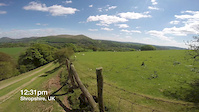
SaveThe Long Mynd is an Area of Outstanding Natural Beauty and is a series of hills with steep gullies locally known as Batches. In fact Minton Batch is regularly featured in MBR and What Mountain Bike magazine as one of the best single track descents in the UK. THe trails have been featured in Single Track, MBR and MBUK. Also featured in video edits on Dirt and Wideopens websites.
Pole Bank, the highest point of Long Mynd is 516 metres above sea level and on a good day Snowdon, Cadair Idris and the Brecon Beacons can easily be seen as can the Malvern hills to the south. There are many excellent trails to explore and there are trails to suit everyone and every ability.
Pole Bank, the highest point of Long Mynd is 516 metres above sea level and on a good day Snowdon, Cadair Idris and the Brecon Beacons can easily be seen as can the Malvern hills to the south. There are many excellent trails to explore and there are trails to suit everyone and every ability.
source: MTB Shropshire
Primary Trail Type: Cross-Country
eBikes Allowed:
Yes
Shuttleable: YES
Land Status: Regional Recreation Area
 google parking directions
This region uses the Uk/Euro style trail grading system.
Activities Click to view
- Mountain Bike
148 trails
- E-Bike
148 trails
- Horse
85 trails
- Hike
149 trails
- Trail Running
149 trails
Region Details
- 19
- 42
- 56
- 21
- 10
Region Status
Open as of Dec 23, 2025Stats
- Avg Trail Rating
- Trails (view details)
- 148
- Trails Mountain Bike
- 148
- Trails E-Bike
- 148
- Trails Horse
- 85
- Trails Hike
- 149
- Trails Trail Running
- 149
- Total Distance
- 143 miles
- Total Descent
- 31,857 ft
- Total Vertical
- 1,373 ft
- Highest Trailhead
- 1,680 ft
- Reports
- 991
- Photos
- 57
- Ridden Counter
- 10,790
Popular Long Mynd Mountain Biking Trails
• 85 ★ 4.0 • 2 miles • 22 ft • 457 •
Fast, technical singletrack, often wet in the track.
• 95 ★ 3.0 • 4,242 ft • 58 ft • 266 •
A left hand variant (going downhill) to ( which goes across the winch line and landing and takeoff area of the Gliding Club. While is a Public Right Of Way, you may be asked to wait for a few minutes for the club to complete the...
• 85 ★ 4.0 • 1,877 ft • 0 ft • 241 •
Good in both directions. Steep and tight at the bottom then a final and difficult steep rocky section at the top when climbing. In descent the rocky section is committing and you need to hit the singletrack exit. Can be walked in either...
• 40 ★ 3.0 • 1 mile • 3 ft • 219 •
Rocky bridleway with some wheel breaking drainage ditches
• 65 ★ 4.5 • 4,814 ft • 36 ft • 215 •
Non technical green lane, largely gravel surface, can be used both ways.
• 90 ★ 0.0 • 1,640 ft • 0 ft • 189 •
Better than down the road, but steep back onto road!
• 80 ★ 2.0 • 1,971 ft • 34 ft • 179 •
Doubletrack link up section. Bridleway.
• 85 ★ 3.0 • 1,637 ft • 11 ft • 178 •
Popular green difficulty doubletrack. This multi-use trail can be used both directions and has a easy overall physical rating. Trail visibility is always easy to follow. On average it takes 1 minutes to complete this trail.
Long Mynd Mountain Bike Routes
★ 5.0 • 30 miles • 2,701 ft • 15 • Loop •
30 miles of mixed terrain and trail types. About 42 miles or so if started and finished in Shrewsbury....
★ 4.0 • 10 miles • 1,302 ft • 5 • Loop •
With the restrictions getting a little stricter, and the news constantly being full of pandemic, the...
14 miles • 1,668 ft • 3 • Loop •
With the restrictions getting a little stricter, and the news constantly being full of pandemic, the...
20 miles • 2,814 ft • 8 • Loop •
The Long Mynd is an Area of Outstanding Natural Beauty and is a series of hills with steep gullies locally...
★ 5.0 • 7 miles • 541 ft • 0 •
A superb way of leaving or accessing the Long Mynd area without using many roads. This trail contains a...
28 miles • 3,477 ft • 2 • Loop •
With the restrictions getting a little stricter, and the news constantly being full of pandemic, the...
Photos of Long Mynd Mountain Bike
Videos of Long Mynd Mountain Bike

trail: Mini Llangollen
3:31 |
478 |
Sep 4, 2019
trail: Minton Batch
4:25 |
264 |
May 18, 2016
trail: Mini Llangollen
0:05 |
377 |
Dec 7, 2014
trail: Minton Batch
7:41 |
177 |
Apr 10, 2014
trail: Cresta Run
4:27 |
256 |
Aug 19, 2013
trail: Minton Batch
5:35 |
260 |
Jun 15, 2011

trail: Batch Valley
0:41 |
112 |
Mar 13, 2011
trail: Batch Valley
2:06 |
64 |
Mar 13, 2011
Recent Trail Reports
| status | trail | date | condition | info | user |
|---|---|---|---|---|---|
| Caradoc South | Dec 23, 2025 @ 9:52am (Europe/London) Dec 23, 2025 | Variable | Eiger3822 | ||
| Caradoc Climb | Dec 23, 2025 @ 9:52am (Europe/London) Dec 23, 2025 | Variable | Eiger3822 | ||
| Hazler to Willstone Bridleway | Dec 23, 2025 @ 9:52am (Europe/London) Dec 23, 2025 | Prevalent Mud | Eiger3822 | ||
| Batch Valley | Nov 10, 2025 @ 9:47am (Europe/London) Nov 10, 2025 | Variable | Eiger3822 | ||
| Mini Llangollen | Nov 10, 2025 @ 9:47am (Europe/London) Nov 10, 2025 | Variable | Eiger3822 | ||
| Cross Dyke Climb | Nov 10, 2025 @ 9:47am (Europe/London) Nov 10, 2025 | Variable | Eiger3822 | ||
| Castle Hill Access Road | Nov 10, 2025 @ 9:47am (Europe/London) Nov 10, 2025 | Variable | Eiger3822 | ||
| Yearlet Flying Descent | Sep 8, 2025 @ 9:48am Sep 8, 2025 | Variable | Eiger3822 | ||
| Short Cut Trail | Sep 8, 2025 @ 9:48am Sep 8, 2025 | Ideal | Eiger3822 | ||
| Haddon Hill Bridleway | Sep 8, 2025 @ 9:48am Sep 8, 2025 | Ideal | Eiger3822 |
Activity Feed
| username | action | type | title | date |
|---|---|---|---|---|
| yman98 | wishlist | trail | activity #96983621 | Jun 14, 2026 @ 10:25am Jun 14, 2026 |
| saSe | wishlist | route | activity #96912789 | Jun 13, 2026 @ 1:43pm Jun 13, 2026 |
| adam0945 | wishlist | region | activity #96814207 | Jun 12, 2026 @ 10:39am Jun 12, 2026 |
| IlliaUMT21R | wishlist | trail | activity #96662981 | Jun 10, 2026 @ 4:11am Jun 10, 2026 |
| Nickfarnell | vote | trail | activity #96543726 | Jun 8, 2026 @ 9:09am Jun 8, 2026 |
Recent Comments
| username | type | title | comment | date |
|---|---|---|---|---|
| report | It was a crap route anyway | Jan 29, 2025 @ 10:19am Jan 29, 2025 | ||
| report | All clear now | Nov 20, 2024 @ 8:15am Nov 20, 2024 | ||
| trail | Tree across trail by second gate. | May 15, 2024 @ 5:42am May 15, 2024 | ||
| trail | Rides like a blue (steep in bits) to the last... | May 30, 2023 @ 5:07am May 30, 2023 | ||
| trail | Good alternative start to Minton batch. | Jan 6, 2023 @ 4:36am Jan 6, 2023 |
Nearby Areas
| name | distance | ||||
|---|---|---|---|---|---|
| Stiperstones | 14 | 12 | 5.6 km | ||
| Eastridge Woods | 13 | 9 | 6.1 km | ||
| Shelve | 3 | 1 | 7.7 km | ||
| Shrewsbury Urban | 2 | 11.5 km | |||
| Hopton Woods | 2 | 10 | 11.9 km |
Local Badges
-

Completionist0 awarded
Bike & Skill Parks
| name | type | city | rating |
|---|---|---|---|
| Church Stretton BMX Track | skill park | Shrewsbury |
Activity Type Stats
| activitytype | trails | distance | descent | descent distance | total vertical | rating | global rank | state rank | photos | reports | routes | ridelogs |
|---|---|---|---|---|---|---|---|---|---|---|---|---|
| Mountain Bike | 148 | 143 miles | 31,857 ft | 76 miles | 1,371 ft | #957 | #36 | 54 | 989 | 13 | 4,394 | |
| E-Bike | 148 | 143 miles | 31,857 ft | 76 miles | 1,371 ft | #424 | #33 | 3 | 917 | 9 | 880 | |
| Horse | 85 | 104 miles | 18,530 ft | 52 miles | 1,371 ft | #69 | #6 | 367 | ||||
| Hike | 149 | 143 miles | 31,857 ft | 76 miles | 1,371 ft | #702 | #17 | 989 | 6 | 713 | ||
| Trail Running | 149 | 143 miles | 31,857 ft | 76 miles | 1,371 ft | #339 | #15 | 989 | 6 | 957 |
Frequently Asked Questions About Long Mynd
▼
What are the highest rated mountain biking trails in Long Mynd?
The highest rated mountain biking trails in Long Mynd are:
- Callow to Small Batch (4.3/5)
- Cow Ridge (4.2/5)
- Grassy Descent To Inwood (4.2/5)
- Woppys Flying Ridge Descent (4.2/5)
- Stanbatch (4.1/5)
▼
What is the best time of the year to ride in Long Mynd?
Based on ride log data, the most popular months to ride in Long Mynd are:
- July (59 activities)
- June (48 activities)
- August (42 activities)
▼
Where can I park to ride in Long Mynd?
There are 12 parking locations listed in Long Mynd. The most popular parking spots are:
- Snailbeach Car Park
- Shooting Box Car Park - Free
- Main Car Park
- Pole Cottage Car Park
- Robin Hoods Butts Car Park - Free
▼
What is the longest trail in Long Mynd?
The longest trail in Long Mynd is Hoar Edge to Ruckley Bridleway at 5.8 km. View all trails sorted by distance.
Activities
Trails
- By Cyclingclaire
 HHTA & contributors
 - Admins: Cyclingclaire, Cyclingclaire, ETP, Cyclingclaire
- #13297 - 29,259 views
- long mynd activity log | embed map of Long Mynd mountain bike trails | long mynd mountain biking points of interest
Downloading of trail gps tracks in kml & gpx formats is enabled for Long Mynd.
You must login to download files.