close
-
Layers w
- Weather Layers
- Pro
- Pro
- Pro
- Pro
- Pro
- Pro
- More Layers
- Pro
- Pro
- Pro
- Pro
-
Upgrade to

3D
Trail Conditions
- Unknown
- Snow Groomed
- Snow Packed
- Snow Covered
- Snow Cover Partial
- Freeze/thaw Cycle
- Icy
- Prevalent Mud
- Wet
- Variable
- Ideal
- Dry
- Very Dry
Trail Flow (Ridden Direction)
Trailforks scans users ridelogs to determine the most popular direction each trail is ridden. A good flowing trail network will have most trails flowing in a single direction according to their intension.
The colour categories are based on what percentage of riders are riding a trail in its intended direction.
The colour categories are based on what percentage of riders are riding a trail in its intended direction.
- > 96%
- > 90%
- > 80%
- > 70%
- > 50%
- < 50%
- bi-directional trail
- no data
Trail Last Ridden
Trailforks scans ridelogs to determine the last time a trail was ridden.
- < 2 days
- < 1 week
- < 2 weeks
- < 1 month
- < 6 months
- > 6 months
Trail Ridden Direction
The intended direction a trail should be ridden.
- Downhill Only
- Downhill Primary
- Both Directions
- Uphill Primary
- Uphill Only
- One Direction
Contribute Details
Colors indicate trail is missing specified detail.
- Description
- Photos
- Description & Photos
- Videos
Trail Popularity ?
Trailforks scans ridelogs to determine which trails are ridden the most in the last 9 months.
Trails are compared with nearby trails in the same city region with a possible 25 colour shades.
Think of this as a heatmap, more rides = more kinetic energy = warmer colors.
- most popular
- popular
- less popular
- not popular
ATV/ORV/OHV Filter
Max Vehicle Width
inches
US Cell Coverage
Legend

Radar Time
Activity Recordings
Trailforks uses anonymized public activity data.
?
Activity Recordings
Trailforks uses anonymized public activity data.
?
Personal Heatmap
▶
Activity Types
all
/
none
▶
Options
2
Date range
month
–
Winter Trails
Warning
A routing network for winter maps does not exist. Selecting trails using the winter trails layer has been disabled.
Missing Trails
Most Popular
Least Popular
Trails are colored based on popularity. The more popular a trail is, the more red. Less popular trails trend towards green.
Jump Magnitude Heatmap
Heatmap of where riders jump on trails. Zoom in to see individual jumps, click circles to view jump details.
BC Backroad Status
![map legend]()
Service Road Atlas is a free to use, community-driven service for viewing and creating reports on the numerous back-country service roads around B.C. and Alberta.

Slope Aspect
Direction the slope faces
Trails Deemphasized
Trails are shown in grey.
Only show trails with no bike usage.
Suggested Layers
Based on selected activity type
Save the current map location and zoom level as your default home location whenever this page is loaded.
Save
No description for Lopar has been added yet!
Login or register to submit one.
This region uses the Uk/Euro style trail grading system.
Activities Click to view
- Mountain Bike
12 trails
- E-Bike
6 trails
- Horse
4 trails
- Hike
11 trails
- Trail Running
11 trails
- Dirtbike/Moto
5 trails
Region Details
- 6
- 1
- 4
Region Status
Open as of Aug 21, 2024Stats
- Avg Trail Rating
- Trails (view details)
- 11
- Trails Mountain Bike
- 12
- Trails E-Bike
- 6
- Trails Horse
- 4
- Trails Hike
- 11
- Trails Trail Running
- 11
- Trails Dirtbike/Moto
- 5
- Trails ATV/ORV/OHV
- 3
- Total Distance
- 8 miles
- Total Descent Distance
- 5 miles
- Total Descent
- 1,320 ft
- Total Vertical
- 241 ft
- Highest Trailhead
- 244 ft
- Reports
- 8
- Photos
- 4
- Ridden Counter
- 363
Popular Lopar Mountain Biking Trails
• 45 ★ 5.0 • 2,454 ft • 10 ft • 15 •
Very hard rocks trail with few drops and steep walls, many rock gardens. Enduro or DH bike preferred.
• 85 ★ 0.0 • 2,119 ft • 0 ft • 14 •
This is new line of . This one is preferred for riding because its more interesting, and ends in more nice spot.
• 65 ★ 5.0 • 1,696 ft • 0 ft • 7 •
Short forest single-trail, works for both up and down. But preferably down. Its completely natural, no jumps, only tight turns. Super fun but short.
• 75 ★ 5.0 • 2,982 ft • 0 ft • 5 •
This is longer version of decent towards Dubac beach. It also covers shorter strava segment that starts of the gravel road.
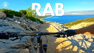
Lopar Mountain Bike Routes
Videos of Lopar Mountain Bike
5:23 |
340 |
Aug 20, 2023 , Lopar

trail: St(d)uby dooby doo
5:22 |
164 |
Aug 16, 2023 , Lopar

trail: Dubac Enduro Longer
5:25 |
199 |
Aug 2, 2023 , Lopar

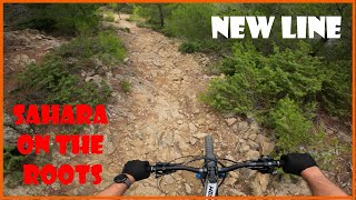
trail: Sahara on the rocks
6:30 |
161 |
Jul 24, 2023 , Lopar

trail: Sahara on the Roots
77 |
Jul 18, 2023 , Lopar
trail: Sahara on the rocks
22:48 |
215 |
Apr 16, 2023 , Lopar

trail: St(d)uby dooby doo
22:48 |
150 |
Apr 16, 2023 , Lopar
trail: U-shumi dooby doo
171 |
Jun 18, 2022 , Lopar
Recent Trail Reports
| status | trail | date | condition | info | user |
|---|---|---|---|---|---|
| Lopar - Veliki Baras | Aug 21, 2024 @ 7:29am Aug 21, 2024 | Dry | Kajakman | ||
| Surići - Mačev vrh | Oct 4, 2022 @ 1:14am Oct 4, 2022 | Ideal | Andrej4321 | ||
| Veliki Baras - Lopar | Aug 23, 2022 @ 2:46am Aug 23, 2022 | Dry | kulsecko | ||
| Sahara on the rocks | Aug 28, 2019 @ 10:54pm Aug 28, 2019 | Dry | mpreuss23 |
Activity Feed
| username | action | type | title | date |
|---|---|---|---|---|
| edolzan | ridden | trail | activity #85881115 | Dec 21, 2025 @ 9:58pm Dec 21, 2025 |
| Pasgita | wishlist | region | activity #81551061 | Oct 2, 2025 @ 9:53am Oct 2, 2025 |
| lo0k23 | ridden | trail | activity #80965725 and 2 more | Sep 23, 2025 @ 11:24am Sep 23, 2025 |
| tomcat37 | ridden | trail | activity #74876446 | Jun 30, 2025 @ 2:00am Jun 30, 2025 |
| Kajakman | add | report | activity #57568623 | Aug 21, 2024 @ 4:09am Aug 21, 2024 |
Recent Comments
| username | type | title | comment | date |
|---|---|---|---|---|
| trail | I was hoping my preview video would help here... | Jun 22, 2024 @ 10:44am Jun 22, 2024 | ||
| trail | With so many different lines it's difficult to... | May 1, 2024 @ 11:05pm May 1, 2024 | ||
| trail | https://www.youtube.com/watch?v=Eh8rrQ-Frsk | Aug 16, 2023 @ 12:01pm Aug 16, 2023 | ||
| trail | https://www.youtube.com/watch?v=htyyPmTwbQs | Aug 12, 2023 @ 11:14am Aug 12, 2023 | ||
| trail | We cleaned the trail from overgrown/fallen... | Jul 24, 2023 @ 1:25am Jul 24, 2023 |
Local Badges
-

Epic Mountain Bike Climb 2k0 awarded -

Climbing 10k Badge0 awarded -

Mountain Biking 100k Badge0 awarded -

Epic Ride Descent 2k0 awarded -

Descent 10k Badge0 awarded -

Descent 100k Badge0 awarded
Activity Type Stats
| activitytype | trails | distance | descent | descent distance | total vertical | rating | global rank | state rank | photos | reports | routes | ridelogs |
|---|---|---|---|---|---|---|---|---|---|---|---|---|
| Mountain Bike | 12 | 8 miles | 1,319 ft | 5 miles | 243 ft | #5,630 | #35 | 4 | 8 | 1 | 772 | |
| E-Bike | 6 | 6 miles | 489 ft | 3 miles | 243 ft | #3,389 | #27 | 6 | 61 | |||
| Horse | 4 | 3 miles | 348 ft | 2 miles | 210 ft | #636 | #8 | |||||
| Hike | 11 | 8 miles | 1,217 ft | 4 miles | 243 ft | #5,810 | #36 | 8 | 48 | |||
| Trail Running | 11 | 8 miles | 1,217 ft | 4 miles | 243 ft | #5,269 | #36 | 8 | 13 | |||
| Dirtbike/Moto | 5 | 5 miles | 489 ft | 3 miles | 210 ft | #430 | #8 | |||||
| ATV/ORV/OHV | 3 | 2 miles | 200 ft | 4,613 ft | 210 ft |
Frequently Asked Questions About Lopar
▼
What are the highest rated mountain biking trails in Lopar?
The highest rated mountain biking trails in Lopar are:
- Sahara on the rocks (4.2/5)
- Dubac Enduro Longer (4.1/5)
- U-shumi dooby doo (4.1/5)
- Sahara on the Roots Pro line (new) (0/5)
▼
What is the best time of the year to ride in Lopar?
Based on ride log data, the most popular months to ride in Lopar are:
- August (8 activities)
- June (6 activities)
- September (4 activities)
▼
Where can I park to ride in Lopar?
Check the Lopar trail map for trailhead and parking information. Community members regularly update access and parking details for trails in the area.
▼
What is the longest trail in Lopar?
The longest trail in Lopar is Dubac Enduro Longer at 2,982 ft. View all trails sorted by distance.
- By tomcat37 & contributors
- Admins: VjekoslavKrsanac
- #23854 - 2,234 views
- lopar activity log | embed map of Lopar mountain bike trails |
Downloading of trail gps tracks in kml & gpx formats is enabled for Lopar.
You must login to download files.