close
-
Layers w
- Weather Layers
- Pro
- Pro
- Pro
- Pro
- Pro
- Pro
- More Layers
- Pro
- Pro
- Pro
- Pro
-
Upgrade to

3D
Trail Conditions
- Unknown
- Snow Groomed
- Snow Packed
- Snow Covered
- Snow Cover Partial
- Freeze/thaw Cycle
- Icy
- Prevalent Mud
- Wet
- Variable
- Ideal
- Dry
- Very Dry
Trail Flow (Ridden Direction)
Trailforks scans users ridelogs to determine the most popular direction each trail is ridden. A good flowing trail network will have most trails flowing in a single direction according to their intension.
The colour categories are based on what percentage of riders are riding a trail in its intended direction.
The colour categories are based on what percentage of riders are riding a trail in its intended direction.
- > 96%
- > 90%
- > 80%
- > 70%
- > 50%
- < 50%
- bi-directional trail
- no data
Trail Last Ridden
Trailforks scans ridelogs to determine the last time a trail was ridden.
- < 2 days
- < 1 week
- < 2 weeks
- < 1 month
- < 6 months
- > 6 months
Trail Ridden Direction
The intended direction a trail should be ridden.
- Downhill Only
- Downhill Primary
- Both Directions
- Uphill Primary
- Uphill Only
- One Direction
Contribute Details
Colors indicate trail is missing specified detail.
- Description
- Photos
- Description & Photos
- Videos
Trail Popularity ?
Trailforks scans ridelogs to determine which trails are ridden the most in the last 9 months.
Trails are compared with nearby trails in the same city region with a possible 25 colour shades.
Think of this as a heatmap, more rides = more kinetic energy = warmer colors.
- most popular
- popular
- less popular
- not popular
ATV/ORV/OHV Filter
Max Vehicle Width
inches
US Cell Coverage
Legend

Radar Time
Activity Recordings
Trailforks uses anonymized public activity data.
?
Activity Recordings
Trailforks uses anonymized public activity data.
?
Personal Heatmap
▶
Activity Types
all
/
none
▶
Options
2
Date range
month
–
Winter Trails
Warning
A routing network for winter maps does not exist. Selecting trails using the winter trails layer has been disabled.
Missing Trails
Most Popular
Least Popular
Trails are colored based on popularity. The more popular a trail is, the more red. Less popular trails trend towards green.
Jump Magnitude Heatmap
Heatmap of where riders jump on trails. Zoom in to see individual jumps, click circles to view jump details.
BC Backroad Status
![map legend]()
Service Road Atlas is a free to use, community-driven service for viewing and creating reports on the numerous back-country service roads around B.C. and Alberta.

Slope Aspect
Direction the slope faces
Trails Deemphasized
Trails are shown in grey.
Only show trails with no bike usage.
Suggested Layers
Based on selected activity type
Save the current map location and zoom level as your default home location whenever this page is loaded.
Save
No description for Los Lagos has been added yet!
Login or register to submit one.
Region Details
- 5
- 4
- 11
- 5
- 1
Stats
- Avg Trail Rating
- Trails (view details)
- 26
- Trails Mountain Bike
- 26
- Trails E-Bike
- 19
- Trails Horse
- 6
- Trails Hike
- 29
- Trails Trail Running
- 31
- Trails Snowshoe
- 1
- Trails Backcountry Ski
- 2
- Total Distance
- 111 miles
- Total Descent
- 14,750 ft
- Total Vertical
- 4,369 ft
- Highest Trailhead
- 4,438 ft
- Reports
- 14
- Photos
- 12
- Ridden Counter
- 730
Sub Regions
- Puerto Varas (26)
- Cerro Phillipi (8)
- Pichijuan (6)
- Volcán Osorno (8)
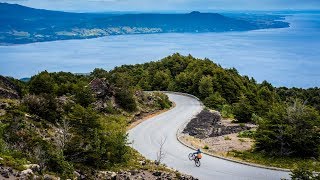
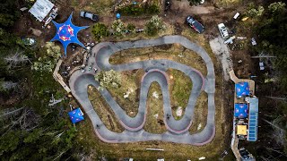
Popular Los Lagos Mountain Biking Trails
• 95 ★ 0.0 • 1,812 ft • 31 ft • 46 •
Pista entretenida de baja velocidad con muchas curvas y peraltes. Cuidado con lluvia que se vuelve muy resbalosa.
• 100 ★ 0.0 • 1,588 ft • 2 ft • 41 •
Circuito hecho con maquina muy entretenido. Corto pero con todo tipo de obstáculos y en medio de la ciudad !!. Mucho cuidado las primeras veces que es muy rápido y se vuelve peligroso. Disfrútalo!
• 90 ★ 0.0 • 2,582 ft • 4 ft • 30 •
Pretty friendly trail, watch out for the last few steep bridges. One of the best trails in Pichijuan, enjoy it!
• 70 ★ 0.0 • 2 miles • 772 ft • 29 •
Path to reach an ancient refuge where the Desolación trail begins.
• 65 ★ 0.0 • 7 miles • 181 ft • 29 •
Very sandy trail with incredible views of the lakes and volcanoes.
• 60 ★ 0.0 • 38 miles • 1,982 ft • 27 •
100km bikeway, bordering Llanquihue's lake and crosses Vicente Perez Rosales National Park.
Los Lagos Mountain Bike Routes
844 miles • 36,518 ft • 0 • Point to Point •
Carretera austral villa ohiggins to puerto Montt
• 2 miles • 436 ft • 5 •
Photos of Los Lagos Mountain Bike


Recent Trail Reports
| status | trail | date | condition | info | user |
|---|---|---|---|---|---|
| Tunel Pichijuan | Jan 4, 2026 @ 10:21am (America/Santiago) Jan 4, 2026 | Unknown | benjaminkronig | ||
| ExVerde Cerro Phillipi | May 13, 2024 @ 5:51am May 13, 2024 | Variable | fyfer | ||
| Joyline Cerro Phillipi | May 13, 2024 @ 5:51am May 13, 2024 | Ideal | fyfer | ||
| PichiJohn's XL Climb Pichijuan | Jul 10, 2023 @ 9:19am Jul 10, 2023 | Dry | B1zbkM | ||
| Classic PJ Pichijuan | Jul 10, 2023 @ 9:19am Jul 10, 2023 | Wet | B1zbkM | ||
| Totoral Puerto Varas | Oct 30, 2022 @ 4:34am Oct 30, 2022 | Dry | Jmobiny | ||
| Ralún Volcán Osorno | Nov 8, 2021 @ 5:03pm Nov 8, 2021 | Wet | vitox44 | ||
| Philippi Road Climb Cerro Phillipi | Sep 5, 2021 @ 12:38pm Sep 5, 2021 | Ideal | Jmobiny | ||
| Escalones Pichijuan | Jan 8, 2021 @ 5:29am Jan 8, 2021 | Ideal | Rodrigocamposm |
Activity Feed
| username | action | type | title | date |
|---|---|---|---|---|
| Marojas | wishlist | trail | activity #93633271 | Apr 29, 2026 @ 12:59am Apr 29, 2026 |
| Akdjajak6dgGGb | ridden | trail | activity #91571556 | Mar 29, 2026 @ 10:46pm Mar 29, 2026 |
| Ciclopatas | ridden | trail | activity #90037477 | Mar 5, 2026 @ 4:43pm Mar 5, 2026 |
| jonathaj | update | region | activity #89474743 | Feb 24, 2026 @ 11:02am Feb 24, 2026 |
| matiasbohmer | wishlist | trail | activity #88537610 | Feb 7, 2026 @ 6:00pm Feb 7, 2026 |
Recent Comments
| username | type | title | comment | date |
|---|---|---|---|---|
| trail | This track is mistaken in the last section... | May 18, 2024 @ 6:59pm May 18, 2024 | ||
| trail | Be sure to bring Pesos for the short ride... | Jan 21, 2020 @ 12:14pm Jan 21, 2020 |
Local Badges
-

Epic Mountain Bike Climb 2k24 awarded -

Climbing 10k Badge8 awarded -

Mountain Biking 100k Badge2 awarded -

Epic Ride Descent 2k24 awarded -

Descent 10k Badge8 awarded -

Descent 100k Badge2 awarded
Local Trail Supporters
![]()
- Blackline Bicicletas
- Joylab Chile
- Ciclopatas
Activity Type Stats
| activitytype | trails | distance | descent | descent distance | total vertical | rating | global rank | state rank | photos | reports | routes | ridelogs |
|---|---|---|---|---|---|---|---|---|---|---|---|---|
| Mountain Bike | 26 | 111 miles | 14,751 ft | 53 miles | 4,370 ft | 12 | 14 | 1 | 5,474 | |||
| E-Bike | 19 | 68 miles | 11,391 ft | 31 miles | 4,370 ft | 11 | 1,321 | |||||
| Horse | 6 | 28 miles | 4,429 ft | 13 miles | 3,422 ft | |||||||
| Hike | 28 | 47 miles | 9,400 ft | 21 miles | 4,370 ft | 8 | 514 | |||||
| Trail Running | 31 | 55 miles | 9,764 ft | 25 miles | 4,370 ft | 8 | 49 | |||||
| Snowshoe | 1 | 2 miles | 20 ft | 420 ft | 751 ft | |||||||
| Backcountry Ski | 2 | 9 miles | 2,976 ft | 6 miles | 2,871 ft | 29 |
Activities
Trails
Points of Interest
- Camping El Laurel
- Domo Volcán Chaitén Viewpoint
- Vista Panomerica Viewpoint
- Modulo Michinmahuida Cabin
- Camping Ventisquero
- Mirador Rincon Viewpoint
- Camping Tawen
- Camping La Junta
- Centro de Visitantes Valle Cochamo Information
- Death Bridge TTF
- Cerro Tres Picos (7,894 ft)
- Cerro Dos Picos (7,822 ft)
- Cerro Premolar (7,648 ft)
- By brenthillier
 NSMBA TRAILFORKS & contributors
 - Admins: MB
- #11463 - 2,855 views
- los lagos activity log | embed map of Los Lagos mountain bike trails | los lagos mountain biking points of interest
Downloading of trail gps tracks in kml & gpx formats is enabled for Los Lagos.
You must login to download files.