close
-
Layers w
- Weather Layers
- Pro
- Pro
- Pro
- Pro
- Pro
- Pro
- More Layers
- Pro
- Pro
- Pro
- Pro
-
Upgrade to

3D
Trail Conditions
- Unknown
- Snow Groomed
- Snow Packed
- Snow Covered
- Snow Cover Partial
- Freeze/thaw Cycle
- Icy
- Prevalent Mud
- Wet
- Variable
- Ideal
- Dry
- Very Dry
Trail Flow (Ridden Direction)
Trailforks scans users ridelogs to determine the most popular direction each trail is ridden. A good flowing trail network will have most trails flowing in a single direction according to their intension.
The colour categories are based on what percentage of riders are riding a trail in its intended direction.
The colour categories are based on what percentage of riders are riding a trail in its intended direction.
- > 96%
- > 90%
- > 80%
- > 70%
- > 50%
- < 50%
- bi-directional trail
- no data
Trail Last Ridden
Trailforks scans ridelogs to determine the last time a trail was ridden.
- < 2 days
- < 1 week
- < 2 weeks
- < 1 month
- < 6 months
- > 6 months
Trail Ridden Direction
The intended direction a trail should be ridden.
- Downhill Only
- Downhill Primary
- Both Directions
- Uphill Primary
- Uphill Only
- One Direction
Contribute Details
Colors indicate trail is missing specified detail.
- Description
- Photos
- Description & Photos
- Videos
Trail Popularity ?
Trailforks scans ridelogs to determine which trails are ridden the most in the last 9 months.
Trails are compared with nearby trails in the same city region with a possible 25 colour shades.
Think of this as a heatmap, more rides = more kinetic energy = warmer colors.
- most popular
- popular
- less popular
- not popular
ATV/ORV/OHV Filter
Max Vehicle Width
inches
US Cell Coverage
Legend

Radar Time
Activity Recordings
Trailforks uses anonymized public activity data.
?
Activity Recordings
Trailforks uses anonymized public activity data.
?
Personal Heatmap
▶
Activity Types
all
/
none
▶
Options
2
Date range
month
–
Winter Trails
Warning
A routing network for winter maps does not exist. Selecting trails using the winter trails layer has been disabled.
Missing Trails
Most Popular
Least Popular
Trails are colored based on popularity. The more popular a trail is, the more red. Less popular trails trend towards green.
Jump Magnitude Heatmap
Heatmap of where riders jump on trails. Zoom in to see individual jumps, click circles to view jump details.
BC Backroad Status
![map legend]()
Service Road Atlas is a free to use, community-driven service for viewing and creating reports on the numerous back-country service roads around B.C. and Alberta.

Slope Aspect
Direction the slope faces
Trails Deemphasized
Trails are shown in grey.
Only show trails with no bike usage.
Suggested Layers
Based on selected activity type
Save the current map location and zoom level as your default home location whenever this page is loaded.
Save
No description for Los Robles has been added yet!
Login or register to submit one.
 google parking directions
google parking directions Activities Click to view
- Mountain Bike
37 trails
- E-Bike
37 trails
- Hike
35 trails
- Trail Running
35 trails
Region Details
- 9
- 6
- 22
Region Status
Caution as of 3 daysStats
- Avg Trail Rating
- Trails (view details)
- 37
- Trails Mountain Bike
- 37
- Trails E-Bike
- 37
- Trails Horse
- 1
- Trails Hike
- 35
- Trails Trail Running
- 35
- Total Distance
- 20 miles
- Total Descent
- 5,386 ft
- Total Vertical
- 1,344 ft
- Highest Trailhead
- 1,581 ft
- Reports
- 648
- Photos
- 83
- Ridden Counter
- 11,770
Popular Los Robles Mountain Biking Trails
• 100 ★ 4.7 • 2,057 ft • 7 ft • 855 •
Maybe the most fun 90 seconds (or less!) in the Los Robles trail network! This is primarily a downhill MTB trail, but hikers are allowed so keep an eye out. Features optional small drops and jumps, and some rollable short steep...
• 90 ★ 4.1 • 1 mile • 176 ft • 753 •
Highly rated popular blue difficulty singletrack. This mountain bike primary trail can be used both directions and has a moderate overall physical rating with a 176 ft blue climb. On average it takes 11 minutes to complete this trail.
• 80 ★ 3.8 • 2,719 ft • 209 ft • 451 •
Just a simple connector up to the truck trail. A couple switchbacks. Depending on rain it can be really dusty
• 90 ★ 4.0 • 1 mile • 148 ft • 397 •
The trail is one you can climb up, ride around some other areas and then have some fun riding down because it can be pretty fast and there are some built in berms to hit as well. Just watch for hikers.
• 75 ★ 3.6 • 2,598 ft • 77 ft • 355 •
Popular green difficulty singletrack. This mountain bike primary trail can be used both directions. On average it takes 5 minutes to complete this trail.
• 75 ★ 2.7 • 1,755 ft • 71 ft • 332 •
This is a multi-use trail, but is divided for most of it's length (bikes and horses on one side, hikers and dogs on the other). This trail would be rated Green if not for the end of the climb, which gets steep and rutted for the last...
• 45 ★ 4.8 • 1,532 ft • 59 ft • 292 •
Moderately popular blue difficulty singletrack. This mountain bike primary trail can be used both directions. It features jump and gap jump. On average it takes 6 minutes to complete this trail.
• 100 ★ 3.5 • 476 ft • 26 ft • 275 •
Popular green difficulty family friendly singletrack. This mountain bike primary trail can be used both directions and has a easy overall physical rating with a 26 ft green climb. Trail visibility is always easy to follow. On average it takes minutes to complete this trail.
Los Robles Mountain Bike Routes
★ 1.0 • 12 miles • 2,021 ft • 7 • Out & Back •
Thousand Oaks from Morepark Road to Newbury Park on the ridge route.
★ 1.0 • 11 miles • 1,936 ft • 16 • Loop •
a good mish mash in the Triunfo/Los Robles areas
• 4 miles • 1,125 ft • 4 •
• 4 miles • 941 ft • 4 •
• 3 miles • 412 ft • 6 •
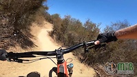
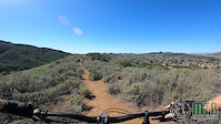
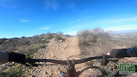
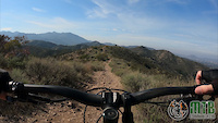
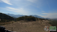
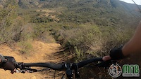
Photos of Los Robles Mountain Bike
Videos of Los Robles Mountain Bike
trail: Mr. Toad's Wild Ride
0:55 |
34 |
Aug 18, 2022
trail: Roadside
0:30 |
20 |
Feb 16, 2022
trail: Conejo Crest
0:14 |
9 |
Jan 3, 2022
trail: Conejo Crest
0:26 |
27 |
Feb 11, 2021
trail: Radioactive
0:57 |
20 |
Feb 11, 2021
trail: Dunk Tank
0:30 |
14 |
Feb 11, 2021
trail: Radioactive
0:06 |
|
Feb 11, 2021
trail: Platoon
2:40 |
15 |
Feb 8, 2021
Current Trail Warnings
| status | trail | date | condition | user | info |
|---|---|---|---|---|---|
| Drop Zone | Jun 20, 2026 @ 11:27am (America/Los_Angeles) 3 days | Dry | Slowestmanalive | Overgrown and giant ruts. Huge potential... |
Recent Trail Reports
Activity Feed
| username | action | type | title | date |
|---|---|---|---|---|
| Slowestmanalive | add | report | activity #97443145 | Jun 20, 2026 @ 4:54pm 2 days |
| Slowestmanalive | comment | trail | activity #97443076 | Jun 20, 2026 @ 4:53pm 2 days |
| MHartong | add | report | activity #97110893 and 1 more | Jun 16, 2026 @ 8:03am Jun 16, 2026 |
| ScottAAJWXC | ridden | trail | activity #95906949 | May 30, 2026 @ 8:04pm May 30, 2026 |
| MHartong | add | report | activity #94974008 and 1 more | May 18, 2026 @ 7:15am May 18, 2026 |
Recent Comments
| username | type | title | comment | date |
|---|---|---|---|---|
| trail | Overgrown and rutted out, but has huge... | Jun 20, 2026 @ 4:53pm 2 days | ||
| trail | I think it is better to climb this and hit... | Mar 22, 2026 @ 9:51pm Mar 22, 2026 | ||
| report | All good | Feb 5, 2026 @ 9:24pm Feb 5, 2026 | ||
| trail | It would be very helpful if it has a sign to... | Feb 5, 2026 @ 9:23pm Feb 5, 2026 | ||
| trail | I climbed this up with my bells on, just in... | Feb 2, 2026 @ 12:03pm Feb 2, 2026 |
Nearby Areas
| name | distance | ||||
|---|---|---|---|---|---|
| Wildwood Regional Park | 7 | 21 | 1 | 3.7 km | |
| Sapwi Trails Park | 6 | 6 | 4.3 km | ||
| Encinal Canyon | 6 | 1 | 4.6 km | ||
| Conejo Canyons Open Space | 7 | 12 | 5 km | ||
| Dos Vientos Open Space | 25 | 27 | 4 | 1 | 5.7 km |
Local Badges
-

Completionist0 awarded
Activity Type Stats
| activitytype | trails | distance | descent | descent distance | total vertical | rating | global rank | state rank | photos | reports | routes | ridelogs |
|---|---|---|---|---|---|---|---|---|---|---|---|---|
| Mountain Bike | 37 | 20 miles | 5,387 ft | 11 miles | 1,345 ft | #2,443 | #846 | 90 | 648 | 2 | 16,068 | |
| E-Bike | 37 | 20 miles | 5,387 ft | 11 miles | 1,345 ft | #2,680 | #863 | 591 | 1 | 3,108 | ||
| Horse | 1 | 427 ft | 36 ft | 348 ft | 36 ft | 41 | ||||||
| Hike | 35 | 20 miles | 5,184 ft | 11 miles | 1,345 ft | #7,348 | #2,696 | 643 | 1 | 572 | ||
| Trail Running | 35 | 20 miles | 5,184 ft | 11 miles | 1,345 ft | #6,453 | #2,062 | 643 | 516 |
Frequently Asked Questions About Los Robles
▼
What are the highest rated mountain biking trails in Los Robles?
The highest rated mountain biking trails in Los Robles are:
- Mr. Toad's Wild Ride (4.5/5)
- Los Robles Dirt Circuit (4.3/5)
- Marbles (4.1/5)
- Rosewood (4.1/5)
- Conejo Crest (4/5)
▼
What is the best time of the year to ride in Los Robles?
Based on ride log data, the most popular months to ride in Los Robles are:
- July (138 activities)
- March (100 activities)
- February (95 activities)
▼
Where can I park to ride in Los Robles?
There are 6 parking locations listed in Los Robles. The most popular parking spots are: View all parking and trailhead locations on the map to plan your visit.
▼
What is the longest trail in Los Robles?
The longest trail in Los Robles is Arroyo Conejo at 2.4 miles. View all trails sorted by distance.
Activities
- By brenthillier
 NSMBA TRAILFORKS & contributors
 - Admins: CORBA
- #4084 - 9,647 views
- los robles activity log | embed map of Los Robles mountain bike trails | los robles mountain biking points of interest
Downloading of trail gps tracks in kml & gpx formats is enabled for Los Robles.
You must login to download files.