close
-
Layers w
- Weather Layers
- Pro
- Pro
- Pro
- Pro
- Pro
- Pro
- More Layers
- Pro
- Pro
- Pro
- Pro
-
Upgrade to

3D
Trail Conditions
- Unknown
- Snow Groomed
- Snow Packed
- Snow Covered
- Snow Cover Partial
- Freeze/thaw Cycle
- Icy
- Prevalent Mud
- Wet
- Variable
- Ideal
- Dry
- Very Dry
Trail Flow (Ridden Direction)
Trailforks scans users ridelogs to determine the most popular direction each trail is ridden. A good flowing trail network will have most trails flowing in a single direction according to their intension.
The colour categories are based on what percentage of riders are riding a trail in its intended direction.
The colour categories are based on what percentage of riders are riding a trail in its intended direction.
- > 96%
- > 90%
- > 80%
- > 70%
- > 50%
- < 50%
- bi-directional trail
- no data
Trail Last Ridden
Trailforks scans ridelogs to determine the last time a trail was ridden.
- < 2 days
- < 1 week
- < 2 weeks
- < 1 month
- < 6 months
- > 6 months
Trail Ridden Direction
The intended direction a trail should be ridden.
- Downhill Only
- Downhill Primary
- Both Directions
- Uphill Primary
- Uphill Only
- One Direction
Contribute Details
Colors indicate trail is missing specified detail.
- Description
- Photos
- Description & Photos
- Videos
Trail Popularity ?
Trailforks scans ridelogs to determine which trails are ridden the most in the last 9 months.
Trails are compared with nearby trails in the same city region with a possible 25 colour shades.
Think of this as a heatmap, more rides = more kinetic energy = warmer colors.
- most popular
- popular
- less popular
- not popular
ATV/ORV/OHV Filter
Max Vehicle Width
inches
US Cell Coverage
Legend

Radar Time
Activity Recordings
Trailforks uses anonymized public activity data.
?
Activity Recordings
Trailforks uses anonymized public activity data.
?
Personal Heatmap
▶
Activity Types
all
/
none
▶
Options
2
Date range
month
–
Winter Trails
Warning
A routing network for winter maps does not exist. Selecting trails using the winter trails layer has been disabled.
Missing Trails
Most Popular
Least Popular
Trails are colored based on popularity. The more popular a trail is, the more red. Less popular trails trend towards green.
Jump Magnitude Heatmap
Heatmap of where riders jump on trails. Zoom in to see individual jumps, click circles to view jump details.
BC Backroad Status
![map legend]()
Service Road Atlas is a free to use, community-driven service for viewing and creating reports on the numerous back-country service roads around B.C. and Alberta.

Slope Aspect
Direction the slope faces
Trails Deemphasized
Trails are shown in grey.
Only show trails with no bike usage.
Suggested Layers
Based on selected activity type
Save the current map location and zoom level as your default home location whenever this page is loaded.
SaveFornstigen and trails around. There is an official route, Lovö-spåret, for MTB with purple marked MTB-signs and blobs.
Primary Trail Type: Cross-Country
AKA: Drottningholm
 google parking directions
This region uses the Uk/Euro style trail grading system.
Activities Click to view
- Mountain Bike
92 trails
- E-Bike
1 trails
- Horse
22 trails
- Hike
115 trails
- Trail Running
116 trails
Region Details
- 32
- 14
- 43
- 3
Region Status
Open as of Mar 20, 2026Stats
- Avg Trail Rating
- Trails (view details)
- 117
- Trails Mountain Bike
- 92
- Trails E-Bike
- 1
- Trails Horse
- 22
- Trails Hike
- 115
- Trails Trail Running
- 116
- Total Distance
- 57 miles
- Total Descent Distance
- 24 miles
- Total Descent
- 4,281 ft
- Total Vertical
- 162 ft
- Highest Trailhead
- 178 ft
- Reports
- 356
- Photos
- 58
- Ridden Counter
- 9,309
Popular Lovön Mountain Biking Trails
• 100 ★ 5.0 • 3,829 ft • 124 ft • 266 •
Popular blue difficulty singletrack. This mountain bike primary trail. On average it takes 8 minutes to complete this trail.
• 95 ★ 4.5 • 1,785 ft • 29 ft • 263 •
Popular blue difficulty singletrack. This multi-use trail can be used both directions. On average it takes 4 minutes to complete this trail.
• 100 ★ 5.0 • 1,722 ft • 17 ft • 247 •
Del av nya MTB-slingan, ersätter
• 100 ★ 5.0 • 2,005 ft • 15 ft • 241 •
Del av Lovö-spåret, lila märkning runt Lovön för MTB.
• 95 ★ 5.0 • 1,906 ft • 13 ft • 240 •
Del av nya MTB-slingan, ersätter Fornstigen. Lila markering i skogen.
• 100 ★ 5.0 • 531 ft • 31 ft • 230 •
Popular blue difficulty singletrack. This mountain bike primary trail can be used both directions. On average it takes 1 minutes to complete this trail.
• 95 ★ 4.0 • 1,079 ft • 3 ft • 228 •
Popular green difficulty singletrack. This mountain bike primary trail can be used both directions. Trail visibility is always easy to follow. On average it takes 1 minutes to complete this trail.
Lovön Mountain Bike Routes
★ 3.4 • 13 miles • 848 ft • 12 • Loop •
Led på Lovön för MTB, följ lila markeringar och skyltar. Riktningsskyltar är antingen märkta "MTB"...
★ 5.0 • 5 miles • 393 ft • 13 • Point to Point •
En rolig och rätt lång sträcka genom hela Lovön. Den börjar nära till Ekerövägen och Karusellplan...
2 miles • 90 ft • 4 •
This is the circular trail Skogsrundan on Lovön. It's has a nice combination of fairly fast flow as well...
• 9 miles • 956 ft • 14 •
• 11 miles • 1,029 ft • 13 •
• 13 miles • 1,311 ft • 14 •
Photos of Lovön Mountain Bike
Videos of Lovön Mountain Bike
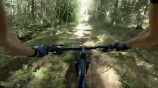
trail: Lambaruddsstigen
3:49 |
302 |
Jun 14, 2020 , Ekerö
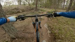
trail: Orange Tillbaka Till Vita
4:07 |
758 |
May 26, 2020 , Ekerö
Recent Trail Reports
Activity Feed
| username | action | type | title | date |
|---|---|---|---|---|
| olaeven | wishlist | region | activity #96436057 | Jun 7, 2026 @ 1:22am Jun 7, 2026 |
| casparlarsson | update | poi | activity #94692870 | May 14, 2026 @ 8:45am May 14, 2026 |
| atakua | add | report | activity #90944822 and 14 more | Mar 20, 2026 @ 2:46pm Mar 20, 2026 |
| Johan4Cu2o | wishlist | route | activity #85403434 | Dec 12, 2025 @ 8:21am Dec 12, 2025 |
| GulaFaran | ridden | route | activity #85237121 | Dec 7, 2025 @ 11:48am Dec 7, 2025 |
Recent Comments
| username | type | title | comment | date |
|---|---|---|---|---|
| report | Gör en till rapport istället. | Aug 17, 2025 @ 11:30am Aug 17, 2025 | ||
| report | Ligger rätt många fallna träd (den här... | Aug 17, 2025 @ 11:02am Aug 17, 2025 | ||
| trail | Mycket kul teknisk cykling. Solklart röd grad... | Jun 22, 2025 @ 6:10am Jun 22, 2025 | ||
| trail | Klart fin och varierad natur med 245... | May 27, 2022 @ 4:16am May 27, 2022 | ||
| trail | Tuff stigning cirka 70m | Mar 30, 2020 @ 3:03pm Mar 30, 2020 |
Nearby Areas
| name | distance | ||||
|---|---|---|---|---|---|
| Södra Ängby - Blackeberg | 7 | 16 | 1.6 km | ||
| Kärsön | 2 | 3 | 1.8 km | ||
| Grimstaskogen | 7 | 57 | 1.8 km | ||
| Judarskogen | 9 | 30 | 2.2 km | ||
| Norra Ängby | 2.5 km |
Local Badges
-

Completionist0 awarded
Activity Type Stats
| activitytype | trails | distance | descent | descent distance | total vertical | rating | global rank | state rank | photos | reports | routes | ridelogs |
|---|---|---|---|---|---|---|---|---|---|---|---|---|
| Mountain Bike | 92 | 44 miles | 3,415 ft | 19 miles | 161 ft | #1,204 | #41 | 52 | 354 | 3 | 7,581 | |
| E-Bike | 1 | 2,087 ft | 20 ft | 1,421 ft | 20 ft | #3,154 | #306 | 314 | 242 | |||
| Horse | 22 | 12 miles | 919 ft | 5 miles | 157 ft | #583 | #34 | 58 | ||||
| Hike | 115 | 56 miles | 4,232 ft | 23 miles | 161 ft | #2,711 | #79 | 6 | 350 | 3 | 107 | |
| Trail Running | 116 | 57 miles | 4,239 ft | 24 miles | 161 ft | #2,090 | #82 | 350 | 4 | 250 |
Frequently Asked Questions About Lovön
▼
What are the highest rated mountain biking trails in Lovön?
The highest rated mountain biking trails in Lovön are:
- Skogsrundan Norra (4.4/5)
- Tillbaka Till Parkeringsrundan (4.2/5)
- Gamla Långa Fornstigen (4.2/5)
- Smitväg Till Lambarudd (4.1/5)
- Lambarudd Ända Ner (4.1/5)
▼
What is the best time of the year to ride in Lovön?
Based on ride log data, the most popular months to ride in Lovön are:
- October (48 activities)
- July (39 activities)
- June (36 activities)
▼
Where can I park to ride in Lovön?
▼
What is the longest trail in Lovön?
The longest trail in Lovön is Orange Tillbaka Till Vita at 1.8 miles. View all trails sorted by distance.
Activities
Trails
Points of Interest
- By swoop-aeg & contributors
- Admins: ollesvenskonthetrail, OrjanX, Hulken, jnasslander, Fluffracka, casparlarsson, svenakela
- #9059 - 8,017 views
- lovön activity log | embed map of Lovön mountain bike trails | lovön mountain biking points of interest
Downloading of trail gps tracks in kml & gpx formats is enabled for Lovön.
You must login to download files.