close
-
Layers w
- Weather Layers
- Pro
- Pro
- Pro
- Pro
- Pro
- Pro
- More Layers
- Pro
- Pro
- Pro
- Pro
-
Upgrade to

3D
Trail Conditions
- Unknown
- Snow Groomed
- Snow Packed
- Snow Covered
- Snow Cover Partial
- Freeze/thaw Cycle
- Icy
- Prevalent Mud
- Wet
- Variable
- Ideal
- Dry
- Very Dry
Trail Flow (Ridden Direction)
Trailforks scans users ridelogs to determine the most popular direction each trail is ridden. A good flowing trail network will have most trails flowing in a single direction according to their intension.
The colour categories are based on what percentage of riders are riding a trail in its intended direction.
The colour categories are based on what percentage of riders are riding a trail in its intended direction.
- > 96%
- > 90%
- > 80%
- > 70%
- > 50%
- < 50%
- bi-directional trail
- no data
Trail Last Ridden
Trailforks scans ridelogs to determine the last time a trail was ridden.
- < 2 days
- < 1 week
- < 2 weeks
- < 1 month
- < 6 months
- > 6 months
Trail Ridden Direction
The intended direction a trail should be ridden.
- Downhill Only
- Downhill Primary
- Both Directions
- Uphill Primary
- Uphill Only
- One Direction
Contribute Details
Colors indicate trail is missing specified detail.
- Description
- Photos
- Description & Photos
- Videos
Trail Popularity ?
Trailforks scans ridelogs to determine which trails are ridden the most in the last 9 months.
Trails are compared with nearby trails in the same city region with a possible 25 colour shades.
Think of this as a heatmap, more rides = more kinetic energy = warmer colors.
- most popular
- popular
- less popular
- not popular
ATV/ORV/OHV Filter
Max Vehicle Width
inches
US Cell Coverage
Legend

Radar Time
Activity Recordings
Trailforks uses anonymized public activity data.
?
Activity Recordings
Trailforks uses anonymized public activity data.
?
Personal Heatmap
▶
Activity Types
all
/
none
▶
Options
2
Date range
month
–
Winter Trails
Warning
A routing network for winter maps does not exist. Selecting trails using the winter trails layer has been disabled.
Missing Trails
Most Popular
Least Popular
Trails are colored based on popularity. The more popular a trail is, the more red. Less popular trails trend towards green.
Jump Magnitude Heatmap
Heatmap of where riders jump on trails. Zoom in to see individual jumps, click circles to view jump details.
BC Backroad Status
![map legend]()
Service Road Atlas is a free to use, community-driven service for viewing and creating reports on the numerous back-country service roads around B.C. and Alberta.

Slope Aspect
Direction the slope faces
Trails Deemphasized
Trails are shown in grey.
Only show trails with no bike usage.
Suggested Layers
Based on selected activity type
Save the current map location and zoom level as your default home location whenever this page is loaded.
Save
No description for Ludlow has been added yet!
Login or register to submit one.
This region uses the Uk/Euro style trail grading system.
Activities Click to view
- Mountain Bike
45 trails
- E-Bike
45 trails
- Gravel Bike
0 trails
- Adaptive Bike
0 trails
- Hike
25 trails
- Trail Running
25 trails
Region Details
- 4
- 2
- 27
- 9
- 3
Region Status
Open as of Oct 4, 2025Stats
- Avg Trail Rating
- Trails (view details)
- 45
- Trails Mountain Bike
- 45
- Trails E-Bike
- 45
- Trails Hike
- 25
- Trails Trail Running
- 25
- Total Distance
- 24 miles
- Total Descent
- 9,488 ft
- Total Vertical
- 1,378 ft
- Highest Trailhead
- 1,878 ft
- Reports
- 341
- Photos
- 118
- Ridden Counter
- 6,656
Sub Regions
-
Hopton Woods
- 2
- 10
- 5
- 1
-
Mortimer Forest and Bringewood
- 17
- 4
- 2
Popular Ludlow Mountain Biking Trails
• 100 ★ 4.6 • 3,389 ft • 3 ft • 452 •
Highly rated popular red difficulty singletrack. This mountain bike primary trail can be used downhill only. On average it takes 6 minutes to complete this trail.
• 100 ★ 3.5 • 4,255 ft • 302 ft • 424 •
Popular blue difficulty singletrack. This mountain bike primary trail can be used uphill only and has a hard overall physical rating with a 302 ft black diamond climb. On average it takes 13 minutes to complete this trail.
• 95 ★ 3.0 • 2,900 ft • 156 ft • 419 •
Popular blue difficulty singletrack. This mountain bike primary trail can be used downhill primary. On average it takes 6 minutes to complete this trail.
• 90 ★ 4.0 • 2,677 ft • 5 ft • 398 •
Popular red difficulty singletrack. This mountain bike primary trail can be used downhill only. On average it takes 3 minutes to complete this trail.
• 80 ★ 3.0 • 1,959 ft • 72 ft • 383 •
Popular blue difficulty mixed. This mountain bike primary trail can be used downhill primary. On average it takes 3 minutes to complete this trail.
• 90 ★ 3.8 • 4,186 ft • 94 ft • 372 •
Popular blue difficulty singletrack. This mountain bike primary trail can be used one direction. On average it takes 7 minutes to complete this trail.
• 95 ★ 3.0 • 4,242 ft • 150 ft • 300 •
Final grind up a fireroad for the end of the Hopton Red.
• 75 ★ 3.0 • 5,243 ft • 109 ft • 259 •
Popular blue difficulty singletrack. This mountain bike primary trail can be used one direction and has a moderate overall physical rating with a 109 ft green climb. Trail visibility is always easy to follow. On average it takes 11 minutes to complete this trail.
Ludlow Mountain Bike Routes
12 miles • 1,969 ft • 2 • Loop •
Some of our local trails for your riding pleasure
7 miles • 1,272 ft • 0 • Loop •
The Mortimer Forest is our local MTB Mecca and is absolutely packed with great trails. Here is a little...
9 miles • 1,791 ft • 0 • Loop •
Some of the slightly more demanding Ludlow stuff.
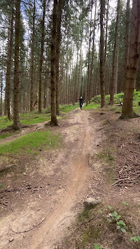
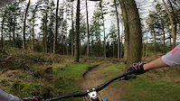
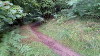
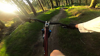
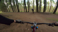
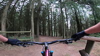
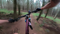
Photos of Ludlow Mountain Bike
Videos of Ludlow Mountain Bike
trail: Bringewood Full DH
0:36 |
54 |
May 6, 2025

trail: Daves Start
2:51 |
|
Jul 15, 2024
trail: Bringewood Full DH
0:18 |
103 |
Apr 21, 2023
trail: Bringewood Full DH
0:09 |
112 |
Oct 26, 2022
trail: Bringewood Full DH
0:14 |
59 |
Oct 26, 2022
trail: Bringewood Full DH
0:06 |
82 |
Oct 26, 2022
trail: Bringewood Full DH
0:14 |
52 |
Aug 17, 2022
trail: Bringewood Full DH
0:36 |
45 |
Aug 16, 2022
Recent Trail Reports
| status | trail | date | condition | info | user |
|---|---|---|---|---|---|
| Another way down | Oct 4, 2025 @ 8:58pm (Europe/London) Oct 4, 2025 | Unknown | Matt-burner | ||
| Bills Bottom | Oct 4, 2025 @ 8:57pm (Europe/London) Oct 4, 2025 | Unknown | Matt-burner | ||
| Bill in a china shop | Oct 4, 2025 @ 8:57pm (Europe/London) Oct 4, 2025 | Unknown | Matt-burner | ||
| Its The 97 | Oct 4, 2025 @ 8:56pm (Europe/London) Oct 4, 2025 | Unknown | Matt-burner | ||
| The Full Monty | Oct 4, 2025 @ 8:56pm (Europe/London) Oct 4, 2025 | Unknown | Matt-burner | ||
| Seed Orchard Climb | Aug 11, 2025 @ 3:27pm Aug 11, 2025 | Very Dry | AdriannJEfKn | ||
| Mere Oak Run | Aug 11, 2025 @ 3:27pm Aug 11, 2025 | Very Dry | AdriannJEfKn | ||
| Tump Run | Aug 11, 2025 @ 3:27pm Aug 11, 2025 | Very Dry | AdriannJEfKn | ||
| Peak Climb | Aug 11, 2025 @ 3:27pm Aug 11, 2025 | Very Dry | AdriannJEfKn | ||
| Carols Climb | Aug 11, 2025 @ 3:27pm Aug 11, 2025 | Very Dry | AdriannJEfKn |
Activity Feed
| username | action | type | title | date |
|---|---|---|---|---|
| trailforks | add | video | activity #96588236 and 5 more | Jun 9, 2026 @ 12:00am Jun 9, 2026 |
| reddels | add | video | activity #96586616 | Jun 8, 2026 @ 11:00pm Jun 8, 2026 |
| trailforks | add | video | activity #96559436 and 9 more | Jun 8, 2026 @ 1:00pm Jun 8, 2026 |
| trailforks | add | video | activity #95572175 and 14 more | May 26, 2026 @ 10:00am May 26, 2026 |
| markyboy1980 | comment | trail | activity #94776494 | May 15, 2026 @ 4:28pm May 15, 2026 |
Recent Comments
| username | type | title | comment | date |
|---|---|---|---|---|
| trail | Sadly no longer due to felling... | May 15, 2026 @ 4:28pm May 15, 2026 | ||
| trail | Rode last night, overgrown in places, needs to... | Jul 27, 2023 @ 4:32am Jul 27, 2023 | ||
| report | trees across the trail but easy to climb over | Mar 9, 2022 @ 12:12pm Mar 9, 2022 | ||
| report | I have cut some of the branches now so it is... | Mar 9, 2022 @ 11:55am Mar 9, 2022 | ||
| trail | Excellent trail, just my sort of thing ,... | Jun 14, 2021 @ 6:20am Jun 14, 2021 |
Local Badges
-

10 Blue Trails130 awarded -

Epic Ride Climb 2k101 awarded -

Climbing 10k Badge54 awarded -

Climbing 100k Badge1 awarded -

Epic Ride Descent 2k120 awarded -

Descent 10k Badge55 awarded
Activity Type Stats
| activitytype | trails | distance | descent | descent distance | total vertical | rating | global rank | state rank | photos | reports | routes | ridelogs |
|---|---|---|---|---|---|---|---|---|---|---|---|---|
| Mountain Bike | 45 | 24 miles | 9,488 ft | 15 miles | 1,378 ft | #3,242 | #105 | 118 | 341 | 4 | 6,239 | |
| E-Bike | 45 | 24 miles | 9,488 ft | 15 miles | 1,378 ft | #3,241 | #112 | 300 | 1 | 1,360 | ||
| Hike | 25 | 16 miles | 5,249 ft | 9 miles | 1,339 ft | #7,160 | #203 | 319 | 323 | |||
| Trail Running | 25 | 16 miles | 5,249 ft | 9 miles | 1,339 ft | #6,670 | #189 | 319 | 99 |
Frequently Asked Questions About Ludlow
▼
What are the best places to ride in Ludlow?
Ludlow has 2 areas to explore for mountain biking. The top rated areas are:
▼
What are the highest rated mountain biking trails in Ludlow?
The highest rated mountain biking trails in Ludlow are:
- Hopton DH 5 (4.4/5)
- Daves Start (4.3/5)
- The Full Monty (4.2/5)
- Bringewood Full DH (4.1/5)
- Another way down (4.1/5)
▼
What is the best time of the year to ride in Ludlow?
Based on ride log data, the most popular months to ride in Ludlow are:
- September (26 activities)
- July (25 activities)
- February (21 activities)
▼
Where can I park to ride in Ludlow?
There are 3 parking locations listed in Ludlow. The most popular parking spots are: View all parking and trailhead locations on the map to plan your visit.
Activities
Trails
Points of Interest
- By haskear ETP & contributors
- Admins: wisey, MathieuC, cemoorelife, Cyclingclaire
- #14763 - 4,998 views
- ludlow activity log | embed map of Ludlow mountain bike trails | ludlow mountain biking points of interest
Downloading of trail gps tracks in kml & gpx formats is enabled for Ludlow.
You must login to download files.