close
-
Layers w
- Weather Layers
- Pro
- Pro
- Pro
- Pro
- Pro
- Pro
- More Layers
- Pro
- Pro
- Pro
- Pro
-
Upgrade to

3D
Trail Conditions
- Unknown
- Snow Groomed
- Snow Packed
- Snow Covered
- Snow Cover Partial
- Freeze/thaw Cycle
- Icy
- Prevalent Mud
- Wet
- Variable
- Ideal
- Dry
- Very Dry
Trail Flow (Ridden Direction)
Trailforks scans users ridelogs to determine the most popular direction each trail is ridden. A good flowing trail network will have most trails flowing in a single direction according to their intension.
The colour categories are based on what percentage of riders are riding a trail in its intended direction.
The colour categories are based on what percentage of riders are riding a trail in its intended direction.
- > 96%
- > 90%
- > 80%
- > 70%
- > 50%
- < 50%
- bi-directional trail
- no data
Trail Last Ridden
Trailforks scans ridelogs to determine the last time a trail was ridden.
- < 2 days
- < 1 week
- < 2 weeks
- < 1 month
- < 6 months
- > 6 months
Trail Ridden Direction
The intended direction a trail should be ridden.
- Downhill Only
- Downhill Primary
- Both Directions
- Uphill Primary
- Uphill Only
- One Direction
Contribute Details
Colors indicate trail is missing specified detail.
- Description
- Photos
- Description & Photos
- Videos
Trail Popularity ?
Trailforks scans ridelogs to determine which trails are ridden the most in the last 9 months.
Trails are compared with nearby trails in the same city region with a possible 25 colour shades.
Think of this as a heatmap, more rides = more kinetic energy = warmer colors.
- most popular
- popular
- less popular
- not popular
ATV/ORV/OHV Filter
Max Vehicle Width
inches
US Cell Coverage
Legend

Radar Time
Activity Recordings
Trailforks uses anonymized public activity data.
?
Activity Recordings
Trailforks uses anonymized public activity data.
?
Personal Heatmap
▶
Activity Types
all
/
none
▶
Options
2
Date range
month
–
Winter Trails
Warning
A routing network for winter maps does not exist. Selecting trails using the winter trails layer has been disabled.
Missing Trails
Most Popular
Least Popular
Trails are colored based on popularity. The more popular a trail is, the more red. Less popular trails trend towards green.
Jump Magnitude Heatmap
Heatmap of where riders jump on trails. Zoom in to see individual jumps, click circles to view jump details.
BC Backroad Status
![map legend]()
Service Road Atlas is a free to use, community-driven service for viewing and creating reports on the numerous back-country service roads around B.C. and Alberta.

Slope Aspect
Direction the slope faces
Trails Deemphasized
Trails are shown in grey.
Only show trails with no bike usage.
Suggested Layers
Based on selected activity type
Save the current map location and zoom level as your default home location whenever this page is loaded.
SaveLuton Park is a multi-use trail system. Please yield to hikers and trail runners. There is a total of 9 miles of trail utilizing a stacked loop system with flatter beginner trails (the Blue and Green Loops) and tighter, hillier advanced trails that include logs and rocks gardens (the Yellow, Orange, Red and Black Loops). The area incorporates pines, meadows, hardwoods, marshes and three bridge crossings over Rum Creek. Please avoid this trail after heavy rain due to the high clay content and low marsh areas near Rum Creek. Luton Park is closed to night riding since all Kent County Parks are only open from dawn to dusk. The good news is that this area is closed to hunting but open to bikes and hiking all year long.
source: Luton Park
 google parking directions
 Activities Click to view
- Mountain Bike
18 trails
- Hike
18 trails
- Trail Running
18 trails
Region Details
- 2
- 9
- 7
Region Status
Open as of Jun 1, 2026Stats
- Avg Trail Rating
- Trails (view details)
- 18
- Trails Mountain Bike
- 18
- Trails Hike
- 18
- Trails Trail Running
- 18
- Total Distance
- 10 miles
- Total Descent
- 881 ft
- Total Vertical
- 120 ft
- Highest Trailhead
- 905 ft
- Reports
- 3,277
- Photos
- 20
- Ridden Counter
- 9,561
Popular Luton Park Mountain Biking Trails
• 80 ★ 3.8 • 4,528 ft • 40 ft • 881 •
Easiest, sweetest, and shortest of all the Luton loops.
• 95 ★ 3.0 • 1,037 ft • 16 ft • 868 •
A short stretch of singletrack alternative to the runs through a burn-managed native prairie. This is a shorter and more entertaining stretch than the .
• 60 ★ 4.4 • 5,036 ft • 82 ft • 864 •
Also includes a "youth striders" trail near the trailhead. This loop is easy enough to take the whole family mountain biking.
• 90 ★ 4.7 • 2 miles • 158 ft • 838 •
Longest loop in the system, and perhaps the most technically interesting though still intermediate.
• 100 ★ 4.8 • 1 mile • 188 ft • 828 •
Alternate route at end available rather than taking flat straight .
• 70 ★ 4.5 • 4,757 ft • 63 ft • 825 •
Short version of the . There are small extensions with technical features available which can get pretty gnarly depending on how washed out the sandy trail has become.
• 95 ★ 3.0 • 538 ft • 2 ft • 724 •
Popular blue difficulty singletrack. This mountain bike primary trail can be used both directions. On average it takes minutes to complete this trail.
• 70 ★ 4.3 • 2,356 ft • 40 ft • 713 •
New extension to the added in early 2017. Will be completed during trail day in May, 2017.
Luton Park Mountain Bike Routes
★ 5.0 • 8 miles • 493 ft • 15 • Loop •
Hand built stacked loop system with a short beginner kids loop.
• 28 miles • 1,687 ft • 33 •
• 20 miles • 1,369 ft • 27 •
• 17 miles • 1,205 ft • 22 •
• 6 miles • 456 ft • 8 •
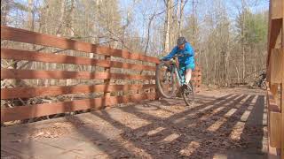
Photos of Luton Park Mountain Bike
Videos of Luton Park Mountain Bike

7:18 |
380 |
Jul 11, 2021

trail: Luton Red Loop
2:42 |
522 |
Jun 3, 2020 , Rockford
trail: Luton Red Loop
2:14 |
720 |
Apr 3, 2018 , Rockford
Recent Trail Reports
| status | trail | date | condition | info | user |
|---|---|---|---|---|---|
| Luton Green Loop - Alternate | Jun 1, 2026 @ 2:57pm (America/Detroit) Jun 1, 2026 | Very Dry | rickplite | ||
| Luton Red Loop | Jun 1, 2026 @ 2:57pm (America/Detroit) Jun 1, 2026 | Very Dry | rickplite | ||
| Luton Black Loop | Jun 1, 2026 @ 2:57pm (America/Detroit) Jun 1, 2026 | Very Dry | rickplite | ||
| Luton Orange Loop | Jun 1, 2026 @ 2:57pm (America/Detroit) Jun 1, 2026 | Very Dry | rickplite | ||
| Luton Prairie Trail | Jun 1, 2026 @ 2:57pm (America/Detroit) Jun 1, 2026 | Very Dry | rickplite | ||
| Luton Yellow Extension 3 | Jun 1, 2026 @ 2:57pm (America/Detroit) Jun 1, 2026 | Very Dry | rickplite | ||
| Luton Yellow Extension 1 | Jun 1, 2026 @ 2:57pm (America/Detroit) Jun 1, 2026 | Very Dry | rickplite | ||
| Luton Yellow Loop | Jun 1, 2026 @ 2:57pm (America/Detroit) Jun 1, 2026 | Very Dry | rickplite | ||
| Luton Green Loop | Jun 1, 2026 @ 2:57pm (America/Detroit) Jun 1, 2026 | Very Dry | rickplite | ||
| Luton Blue Loop | Sep 12, 2025 @ 12:17pm (America/Detroit) Sep 12, 2025 | Dry | dhunsber |
Activity Feed
| username | action | type | title | date |
|---|---|---|---|---|
| EthanYwvHde | ridden | trail | activity #97071185 | Jun 15, 2026 @ 4:03pm Jun 15, 2026 |
| campkarl | ridden | region | activity #96559716 | Jun 8, 2026 @ 1:04pm Jun 8, 2026 |
| rickplite | add | report | activity #96048916 and 8 more | Jun 1, 2026 @ 4:44pm Jun 1, 2026 |
| H9Jl09 | wishlist | region | activity #93746498 | Apr 30, 2026 @ 5:44pm Apr 30, 2026 |
| DNbeSP | wishlist | route | activity #92291314 | Apr 9, 2026 @ 5:30pm Apr 9, 2026 |
Recent Comments
| username | type | title | comment | date |
|---|---|---|---|---|
| report | Large tree partially blew down near the narrow... | Jun 4, 2020 @ 10:52am Jun 4, 2020 | ||
| report | Great riding today. Snow pack was great,... | Feb 11, 2020 @ 1:50pm Feb 11, 2020 | ||
| report | Disregard this post. Somehow it showed up from... | Jan 6, 2019 @ 6:46am Jan 6, 2019 | ||
| trail | Heads up! Tree on ground towards end of black. | Jul 16, 2018 @ 4:15pm Jul 16, 2018 | ||
| report | Trails are to wet and muddy | Feb 23, 2018 @ 5:36pm Feb 23, 2018 |
Nearby Areas
| name | distance | ||||
|---|---|---|---|---|---|
| Cannon Township | 2.1 km | ||||
| Cannon Township Trails | 1 | 2.2 km | |||
| Pando Sports Park | 1 | 3.3 km | |||
| Merrell Trails | 3 | 9 | 2 | 3.7 km | |
| Cannonsburg Ski Area | 6 | 9 | 4.1 km |
Activity Type Stats
| activitytype | trails | distance | descent | descent distance | total vertical | rating | global rank | state rank | photos | reports | routes | ridelogs |
|---|---|---|---|---|---|---|---|---|---|---|---|---|
| Mountain Bike | 18 | 10 miles | 879 ft | 4 miles | 121 ft | #1,137 | #394 | 20 | 3,275 | 2 | 11,034 | |
| Hike | 18 | 10 miles | 879 ft | 4 miles | 121 ft | #11,431 | #4,616 | 3,276 | 216 | |||
| Trail Running | 18 | 10 miles | 879 ft | 4 miles | 121 ft | #9,915 | #3,647 | 3,276 | 261 |
Frequently Asked Questions About Luton Park
▼
What are the highest rated mountain biking trails in Luton Park?
The highest rated mountain biking trails in Luton Park are:
- Luton Black Loop (4.4/5)
- Luton Red Loop (4.4/5)
- Luton Yellow Loop (4.2/5)
- Luton Green Loop (4.1/5)
- Luton Green Loop - Alternate (4.1/5)
▼
What is the best time of the year to ride in Luton Park?
Based on ride log data, the most popular months to ride in Luton Park are:
- July (71 activities)
- August (54 activities)
- June (53 activities)
▼
Where can I park to ride in Luton Park?
▼
What is the longest trail in Luton Park?
The longest trail in Luton Park is Luton Black Loop at 2.4 miles. View all trails sorted by distance.
Activities
Trails
Points of Interest
- By markholloway
 Trailforks Map Team & contributors
 - Admins: WMMBA
- #9720 - 19,404 views
- luton park activity log | embed map of Luton Park mountain bike trails | luton park mountain biking points of interest
Downloading of trail gps tracks in kml & gpx formats is enabled for Luton Park.
You must login to download files.