close
-
Layers w
- Weather Layers
- Pro
- Pro
- Pro
- Pro
- Pro
- Pro
- More Layers
- Pro
- Pro
- Pro
- Pro
-
Upgrade to

3D
Trail Conditions
- Unknown
- Snow Groomed
- Snow Packed
- Snow Covered
- Snow Cover Partial
- Freeze/thaw Cycle
- Icy
- Prevalent Mud
- Wet
- Variable
- Ideal
- Dry
- Very Dry
Trail Flow (Ridden Direction)
Trailforks scans users ridelogs to determine the most popular direction each trail is ridden. A good flowing trail network will have most trails flowing in a single direction according to their intension.
The colour categories are based on what percentage of riders are riding a trail in its intended direction.
The colour categories are based on what percentage of riders are riding a trail in its intended direction.
- > 96%
- > 90%
- > 80%
- > 70%
- > 50%
- < 50%
- bi-directional trail
- no data
Trail Last Ridden
Trailforks scans ridelogs to determine the last time a trail was ridden.
- < 2 days
- < 1 week
- < 2 weeks
- < 1 month
- < 6 months
- > 6 months
Trail Ridden Direction
The intended direction a trail should be ridden.
- Downhill Only
- Downhill Primary
- Both Directions
- Uphill Primary
- Uphill Only
- One Direction
Contribute Details
Colors indicate trail is missing specified detail.
- Description
- Photos
- Description & Photos
- Videos
Trail Popularity ?
Trailforks scans ridelogs to determine which trails are ridden the most in the last 9 months.
Trails are compared with nearby trails in the same city region with a possible 25 colour shades.
Think of this as a heatmap, more rides = more kinetic energy = warmer colors.
- most popular
- popular
- less popular
- not popular
ATV/ORV/OHV Filter
Max Vehicle Width
inches
US Cell Coverage
Legend

Radar Time
Activity Recordings
Trailforks uses anonymized public activity data.
?
Activity Recordings
Trailforks uses anonymized public activity data.
?
Personal Heatmap
▶
Activity Types
all
/
none
▶
Options
2
Date range
month
–
Winter Trails
Warning
A routing network for winter maps does not exist. Selecting trails using the winter trails layer has been disabled.
Missing Trails
Most Popular
Least Popular
Trails are colored based on popularity. The more popular a trail is, the more red. Less popular trails trend towards green.
Jump Magnitude Heatmap
Heatmap of where riders jump on trails. Zoom in to see individual jumps, click circles to view jump details.
BC Backroad Status
![map legend]()
Service Road Atlas is a free to use, community-driven service for viewing and creating reports on the numerous back-country service roads around B.C. and Alberta.

Slope Aspect
Direction the slope faces
Trails Deemphasized
Trails are shown in grey.
Only show trails with no bike usage.
Suggested Layers
Based on selected activity type
Save the current map location and zoom level as your default home location whenever this page is loaded.
Save
No description for Lyman has been added yet!
Login or register to submit one.
Activities Click to view
- Mountain Bike
28 trails
- E-Bike
7 trails
- Gravel Bike
0 trails
- Adaptive Bike
0 trails
- Horse
25 trails
- Hike
29 trails
- Trail Running
29 trails
- Dirtbike/Moto
7 trails
- ATV/ORV/OHV
7 trails
Region Details
- 4
- 5
- 9
- 4
Region Status
Open as of Aug 24, 2024Stats
- Avg Trail Rating
- Trails (view details)
- 22
- Trails Mountain Bike
- 28
- Trails E-Bike
- 7
- Trails Horse
- 25
- Trails Hike
- 29
- Trails Trail Running
- 29
- Trails Dirtbike/Moto
- 7
- Trails ATV/ORV/OHV
- 7
- Total Distance
- 52 miles
- Total Descent
- 9,013 ft
- Total Vertical
- 3,836 ft
- Highest Trailhead
- 11,430 ft
- Reports
- 4
- Photos
- 73
- Ridden Counter
- 50
Articles
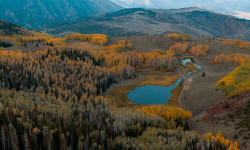
Utah’s Fishlake National Forest Is Magic in the Fall
Nov 9, 2021 from outsideonline.com
The forest is a sight to behold when the vibrant foliage is on full display
Sub Regions
-
Fish Lake
- 2
- 19
- 17
- 5
Popular Lyman Mountain Biking Trails
• 100 ★ 0.0 • 4 miles • 1,015 ft • 7 •
Forest Service OHV trail climbing up onto the south end of Fish Lake Mountain and traversing across the top to Fish Lake Hightop. Starts off with a short but insanely steep loose climb but once on top, it's a beautiful ride across the...
• 5 ★ 0.0 • 3 miles • 153 ft • 6 • • horse
Beautiful natural trail connecting the main Fishlake perimeter trail with . Lots of creek crossings, some with bridges, some without. Beautiful meadows and aspens! A couple very rough rock garden stretches.
• 5 ★ 0.0 • 7 miles • 2,391 ft • 5 • • hike
Wild old horse/hiking trail following between Johnson's Reservoir and Fish Lake Hightop. Like everything else around Fish Lake, expect to find a very rough, natural forest trail. Going up, plan on about 50/50 riding and hiking. Coming...
• 5 ★ 1.0 • 7 miles • 1,154 ft • 5 • • hike
Rough, steep, natural singletrack. The climb up to from Fish Lake is absoluly a hike-a-bike. Horses and cows keep this torn up and loose
• 5 ★ 0.0 • 3 miles • 259 ft • 4 • • hike
Beautiful trail that runs along the creek and the west side of Johnsons Reservoir. There's one stretch in the middle that is insanely rocky!
• 90 ★ 5.0 • 3 miles • 0 ft • 3 • • hike
Rough old natural trail connecting from Fish Lake Hightop down to Fish Lake. Lot of hike-a-biking going up, wild gnarly descent down with lots of steep loose sections and wild rock gardens. Gorgeous forest riding!
• 5 ★ 0.0 • 3,304 ft • 0 ft • 3 • • hike
Short forest trail connecting the Crater Ivie Trail wih the Johnson's reservoir loop
• 5 ★ 0.0 • 4 miles • 1,359 ft • 3 •
Yellow ledges ATV 2-track with plenty of rocky and loose sections. Nothing amazing in terms of mountain biking, but cool area to explore nonetheless, and fast descending in sections. Climbs into a beautiful, high elevation valley above...
Lyman Mountain Bike Routes
36 miles • 5,267 ft • 3 • Loop •
Loop for bikepacking, mostly dirt road and easy singletrack with difficult to navigate hightop trail at...
9 miles • 2,394 ft • 0 • Loop •
Adventure riding. Mix of ATV 2-track and infrequently used and periodically overgrown hiking trails in...
Photos of Lyman Mountain Bike
Videos of Lyman Mountain Bike
youtuber
![Wild Wet Weather on Thousand Lake Mountain! |...]()
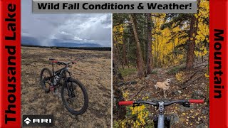
trail: Lakes Trail/Horse Valley
58:40 |
41 |
Oct 17, 2025 , Lyman
youtuber
![Up to Willie's Flat & down Lower UM Creek!...]()
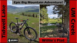
52:28 |
55 |
Sep 26, 2025 , Lyman
youtuber
![Aspens in glorious fall color on the...]()

trail: Neal's Flat
34:17 |
97 |
Oct 13, 2024 , Lyman
youtuber
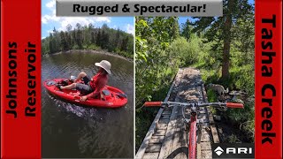
![Rugged & Spectacular Riding + Pedal...]()

trail: South Tasha (Frying Pan)
45:06 |
77 |
Jun 28, 2024 , Lyman
youtuber
![Rugged & Spectacular Riding + Pedal...]()
trail: Reflection Spring
45:06 |
76 |
Jun 28, 2024 , Lyman
youtuber
![Rugged & Spectacular Riding + Pedal...]()

trail: Crater-Johnson Connector
45:06 |
60 |
Jun 28, 2024 , Lyman
youtuber
![Rugged Hardtail Exploration in Pole & Ivie...]()

trail: Crater - Ivie Canyon
43:58 |
91 |
Jun 21, 2024 , Lyman
youtuber
![Rugged Hardtail Exploration in Pole & Ivie...]()
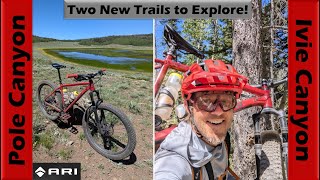
trail: Pole Canyon
43:58 |
82 |
Jun 21, 2024 , Lyman
Recent Trail Reports
| status | trail | date | condition | info | user |
|---|---|---|---|---|---|
| Pelican Canyon | Aug 24, 2024 @ 2:52pm Aug 24, 2024 | Ideal | MountainBikeBill SDMBA | ||
| Crater Lakes | Sep 23, 2022 @ 1:39pm Sep 23, 2022 | Unknown | jentzsch03 | ||
| Hightop Trail (South) | Aug 28, 2021 @ 9:20am Aug 28, 2021 | Dry | Zargyle | ||
| Lakes Trail/Horse Valley | Sep 3, 2019 @ 4:45am Sep 3, 2019 | Dry | burckc |
National Scenic Trails & Official Routes
-
Great Western Trail
- Mountain Bike
- E-Bike
- Horse
- Hike
- Trail Running
- Dirtbike/Moto
- ATV/ORV/OHV

Activity Feed
| username | action | type | title | date |
|---|---|---|---|---|
| uBvXWl | vote | trail | activity #95381123 | May 23, 2026 @ 11:38pm May 23, 2026 |
| BlairgkrtKo | wishlist | region | activity #91914367 | Apr 4, 2026 @ 10:56am Apr 4, 2026 |
| minerbiker | add | video | activity #82514636 | Oct 17, 2025 @ 10:58am Oct 17, 2025 |
| Munki | wishlist | trail | activity #82332509 | Oct 14, 2025 @ 8:44am Oct 14, 2025 |
| minerbiker | add | photo | activity #81376506 and 3 more | Sep 29, 2025 @ 1:26pm Sep 29, 2025 |
Recent Comments
| username | type | title | comment | date |
|---|---|---|---|---|
| trail | One of the few trails in the area that are... | Mar 20, 2021 @ 6:19pm Mar 20, 2021 | ||
| trail | I was looking for a fun downhill & had a... | Sep 15, 2020 @ 7:20pm Sep 15, 2020 | ||
| trail | Not really a mountain bike trail. At least... | Aug 1, 2020 @ 7:29pm Aug 1, 2020 | ||
| trail | This trail has huge potential but it needs a... | Sep 2, 2019 @ 3:32pm Sep 2, 2019 |
Local Badges
-

Epic Mountain Bike Climb 2k3 awarded -

Climbing 10k Badge1 awarded -

Mountain Biking 100k Badge0 awarded -

Epic Ride 50k47 awarded -

Epic Ride Descent 2k2 awarded -

Descent 10k Badge1 awarded
Activity Type Stats
| activitytype | trails | distance | descent | descent distance | total vertical | rating | global rank | state rank | photos | reports | routes | ridelogs |
|---|---|---|---|---|---|---|---|---|---|---|---|---|
| Mountain Bike | 28 | 52 miles | 9,012 ft | 18 miles | 3,835 ft | #7,590 | #2,492 | 59 | 4 | 2 | 491 | |
| E-Bike | 7 | 17 miles | 2,274 ft | 4 miles | 3,835 ft | #5,737 | #1,771 | 2 | 1 | 26 | ||
| Horse | 25 | 41 miles | 8,458 ft | 16 miles | 3,835 ft | #1,299 | #794 | 3 | 1 | 1 | ||
| Hike | 29 | 52 miles | 9,012 ft | 18 miles | 3,835 ft | #2,600 | #1,012 | 14 | 4 | 1 | 208 | |
| Trail Running | 29 | 52 miles | 9,012 ft | 18 miles | 3,835 ft | #4,453 | #1,364 | 4 | 1 | 40 | ||
| Dirtbike/Moto | 7 | 14 miles | 673 ft | 2 miles | 3,835 ft | #1,070 | #422 | 10 | ||||
| ATV/ORV/OHV | 7 | 14 miles | 673 ft | 2 miles | 3,835 ft | #799 | #353 | 7 |
Frequently Asked Questions About Lyman
▼
What are the best places to ride in Lyman?
Lyman has 1 areas to explore for mountain biking. The top rated areas are:
▼
What are the highest rated mountain biking trails in Lyman?
The highest rated mountain biking trails in Lyman are:
- Pelican Canyon (4.1/5)
- Crater - Ivie Canyon (3.6/5)
- Hightop Trail (South) (0/5)
- Neal's Flat (0/5)
- Doctor Creek (0/5)
▼
What is the best time of the year to ride in Lyman?
Based on ride log data, the most popular months to ride in Lyman are:
- July (12 activities)
- June (11 activities)
- May (9 activities)
▼
Where can I park to ride in Lyman?
There are 1 parking locations listed in Lyman. The most popular parking spots are:
Activities
Trails
Points of Interest
- By Ceradini & contributors
- Admins: jkwilliamz, UtahJohn, jpmcghee, jasonmalczyk
- #29548 - 1,470 views
- lyman activity log | embed map of Lyman mountain bike trails | lyman mountain biking points of interest
Downloading of trail gps tracks in kml & gpx formats is enabled for Lyman.
You must login to download files.