close
-
Layers w
- Weather Layers
- Pro
- Pro
- Pro
- Pro
- Pro
- Pro
- More Layers
- Pro
- Pro
- Pro
- Pro
-
Upgrade to

3D
Trail Conditions
- Unknown
- Snow Groomed
- Snow Packed
- Snow Covered
- Snow Cover Partial
- Freeze/thaw Cycle
- Icy
- Prevalent Mud
- Wet
- Variable
- Ideal
- Dry
- Very Dry
Trail Flow (Ridden Direction)
Trailforks scans users ridelogs to determine the most popular direction each trail is ridden. A good flowing trail network will have most trails flowing in a single direction according to their intension.
The colour categories are based on what percentage of riders are riding a trail in its intended direction.
The colour categories are based on what percentage of riders are riding a trail in its intended direction.
- > 96%
- > 90%
- > 80%
- > 70%
- > 50%
- < 50%
- bi-directional trail
- no data
Trail Last Ridden
Trailforks scans ridelogs to determine the last time a trail was ridden.
- < 2 days
- < 1 week
- < 2 weeks
- < 1 month
- < 6 months
- > 6 months
Trail Ridden Direction
The intended direction a trail should be ridden.
- Downhill Only
- Downhill Primary
- Both Directions
- Uphill Primary
- Uphill Only
- One Direction
Contribute Details
Colors indicate trail is missing specified detail.
- Description
- Photos
- Description & Photos
- Videos
Trail Popularity ?
Trailforks scans ridelogs to determine which trails are ridden the most in the last 9 months.
Trails are compared with nearby trails in the same city region with a possible 25 colour shades.
Think of this as a heatmap, more rides = more kinetic energy = warmer colors.
- most popular
- popular
- less popular
- not popular
ATV/ORV/OHV Filter
Max Vehicle Width
inches
US Cell Coverage
Legend

Radar Time
Activity Recordings
Trailforks uses anonymized public activity data.
?
Activity Recordings
Trailforks uses anonymized public activity data.
?
Personal Heatmap
▶
Activity Types
all
/
none
▶
Options
2
Date range
month
–
Winter Trails
Warning
A routing network for winter maps does not exist. Selecting trails using the winter trails layer has been disabled.
Missing Trails
Most Popular
Least Popular
Trails are colored based on popularity. The more popular a trail is, the more red. Less popular trails trend towards green.
Jump Magnitude Heatmap
Heatmap of where riders jump on trails. Zoom in to see individual jumps, click circles to view jump details.
BC Backroad Status
![map legend]()
Service Road Atlas is a free to use, community-driven service for viewing and creating reports on the numerous back-country service roads around B.C. and Alberta.

Slope Aspect
Direction the slope faces
Trails Deemphasized
Trails are shown in grey.
Only show trails with no bike usage.
Suggested Layers
Based on selected activity type
Save the current map location and zoom level as your default home location whenever this page is loaded.
Save
No description for Lynchburg has been added yet!
Login or register to submit one.
Activities Click to view
- Mountain Bike
113 trails
- E-Bike
25 trails
- Gravel Bike
0 trails
- Adaptive Bike
0 trails
- Winter Fat Bike
0 trails
- Hike
109 trails
- Trail Running
109 trails
Region Details
- 25
- 2
- 26
- 48
- 11
- 1
Region Status
Open as of Jun 1, 2026Local Trail Association
Stats
- Avg Trail Rating
- Trails (view details)
- 113
- Trails Mountain Bike
- 114
- Trails E-Bike
- 25
- Trails Hike
- 109
- Trails Trail Running
- 109
- Total Distance
- 83 miles
- Total Descent
- 17,880 ft
- Total Vertical
- 806 ft
- Highest Trailhead
- 1,340 ft
- Reports
- 2,464
- Photos
- 154
- Ridden Counter
- 8,173
Sub Regions
-
Blackwater Creek Trails
- 8
-
Liberty Mountain
- 9
- 31
- 9
- 1
-
Lynchburg College
- 1
- 1
-
Peaks View Park
- 2
- 8
- 16
- 2
Popular Lynchburg Mountain Biking Trails
• 85 ★ 3.5 • 1,624 ft • 54 ft • 160 •
A multi-use trail paralleling Candler's Mountain Road from the southwest corner of the Snowflex parking lot. There are two lines to drop down to road bed level - the one nearest the parking lot is steep and rocky (about a five foot...
• 90 ★ 4.5 • 4,641 ft • 120 ft • 152 •
Bench cut trail with small climbs and gentle descents in both directions. Some off camber roots and some rocks.
• 100 ★ 4.0 • 410 ft • 15 ft • 149 •
A short section of singletrack to connect the paved Peaks View Park bike path to either Trail or Grapevine - it's got one switchback and a mild pitch with a couple of roots and rocks to navigate.
• 90 ★ 4.4 • 1,760 ft • 30 ft • 149 •
In this direction, starts as a bench cut trail before entering a section of ~5 foot rollers. After a rooty, right-handed turn down a 6 foot hill, it enters a section of smaller rollers with roots and turns. It ends in a flat section...
• 90 ★ 4.0 • 560 ft • 0 ft • 146 •
Popular green difficulty singletrack. This mountain bike primary trail can be used downhill primary. On average it takes minutes to complete this trail.
• 90 ★ 4.4 • 1,614 ft • 41 ft • 145 •
Popular blue difficulty singletrack. This mountain bike primary trail can be used both directions. On average it takes 2 minutes to complete this trail.
• 75 ★ 3.8 • 2,139 ft • 0 ft • 144 •
A machine-made trail with a few wooden wall rides, some table top and gap jumps, and berms. There are several alternate lines, so repeated rides are a bonus!
• 95 ★ 4.0 • 1,008 ft • 69 ft • 141 •
Popular blue difficulty singletrack. This mountain bike primary trail can be used both directions. On average it takes 2 minutes to complete this trail.
Lynchburg Mountain Bike Routes
★ 5.0 • 17 miles • 2,938 ft • 11 • Loop •
Many of the best downhills and mostly fire road climbs
9 miles • 1,205 ft • 28 • Loop •
Moderate Loop at Candlers Mountain
7 miles • 610 ft • 41 • Loop • Race •
A varied course with lots of short, punchy climbs, rocks, roots, and some flowy sections. Starts in the...
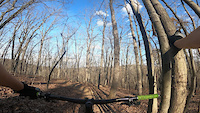
Photos of Lynchburg Mountain Bike
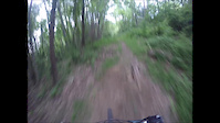
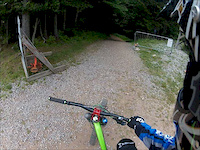
Videos of Lynchburg Mountain Bike
trail: Happy Face
0:03 |
165 |
Apr 12, 2021

trail: Upper Psycho-Pathé
0:19 |
278 |
Nov 22, 2020

trail: Upper Psycho-Pathé
0:24 |
44347 |
Sep 27, 2016

trail: Upper Psycho-Pathé
0:21 |
|
Sep 26, 2016

trail: Upper Psycho-Pathé
0:21 |
|
Sep 26, 2016

trail: Upper Psycho-Pathé
0:29 |
749 |
Sep 26, 2016
trail: Downhill Run
0:10 |
133 |
Jan 15, 2016
trail: Fire Road
3:11 |
2619 |
Jun 18, 2012
Recent Trail Reports
| status | trail | date | condition | info | user |
|---|---|---|---|---|---|
| Mimosa Trail | Apr 15, 2026 @ 11:40am (America/New_York) Apr 15, 2026 | Dry | jasonkendall GLOC | ||
| Bottom Out | Apr 15, 2026 @ 11:40am (America/New_York) Apr 15, 2026 | Dry | jasonkendall GLOC | ||
| Roller Coaster | Apr 15, 2026 @ 11:40am (America/New_York) Apr 15, 2026 | Ideal | jasonkendall GLOC | ||
| Slick Rock | Apr 15, 2026 @ 11:40am (America/New_York) Apr 15, 2026 | Ideal | jasonkendall GLOC | ||
| Trailhead I Trail | Apr 15, 2026 @ 11:40am (America/New_York) Apr 15, 2026 | Ideal | jasonkendall GLOC | ||
| Jump Line - Beginner | Apr 15, 2026 @ 11:40am (America/New_York) Apr 15, 2026 | Ideal | jasonkendall GLOC | ||
| Jump Line - Advanced | Apr 15, 2026 @ 11:40am (America/New_York) Apr 15, 2026 | Ideal | jasonkendall GLOC | ||
| Flow/Pump Trail | Apr 15, 2026 @ 11:40am (America/New_York) Apr 15, 2026 | Ideal | jasonkendall GLOC | ||
| Expert Jump Line | Apr 15, 2026 @ 11:40am (America/New_York) Apr 15, 2026 | Ideal | jasonkendall GLOC | ||
| Rock Pile | Apr 15, 2026 @ 11:40am (America/New_York) Apr 15, 2026 | Dry | jasonkendall GLOC |
Activity Feed
| username | action | type | title | date |
|---|---|---|---|---|
| Jjergens | wishlist | route | activity #96431936 and 1 more | Jun 6, 2026 @ 10:53pm Jun 6, 2026 |
| Jjergens | wishlist | region | activity #96431876 | Jun 6, 2026 @ 10:49pm Jun 6, 2026 |
| KevinDdFBEU | wishlist | region | activity #95677005 | May 27, 2026 @ 6:23pm May 27, 2026 |
| KevinDdFBEU | wishlist | region | activity #95676906 | May 27, 2026 @ 6:22pm May 27, 2026 |
| puddlesplasher77 | wishlist | route | activity #95540643 | May 25, 2026 @ 8:02pm May 25, 2026 |
Recent Comments
| username | type | title | comment | date |
|---|---|---|---|---|
| trail | Huge tree down in the trail after first... | Jul 24, 2025 @ 5:19pm Jul 24, 2025 | ||
| trail | dd | Nov 1, 2024 @ 2:40pm Nov 1, 2024 | ||
| trail | Mid | Nov 1, 2024 @ 2:01pm Nov 1, 2024 | ||
| report | Preach. This neglected area has huge potential. | Mar 22, 2022 @ 7:05am Mar 22, 2022 | ||
| trail | As others have said, needs some love. As do... | Mar 21, 2022 @ 5:16pm Mar 21, 2022 |
Local Badges
-

10 Green Trails70 awarded -

10 Blue Trails105 awarded -

Epic Ride Climb 2k14 awarded -

Climbing 10k Badge51 awarded -

Climbing 100k Badge13 awarded -

Epic Ride Descent 2k13 awarded
Local Mountain Biking Directory
-
Greater Lynchburg Off-Road CyclistsClub
![Greater Lynchburg Off-Road Cyclists]()
-
Blackwater Bike ShopBike Shop
![Blackwater Bike Shop]()
-
Bikes UnlimitedBike Shop
Local Trail Supporters
- Liberty University
Activity Type Stats
| activitytype | trails | distance | descent | descent distance | total vertical | rating | global rank | state rank | photos | reports | routes | ridelogs |
|---|---|---|---|---|---|---|---|---|---|---|---|---|
| Mountain Bike | 113 | 83 miles | 17,881 ft | 43 miles | 807 ft | #774 | #300 | 108 | 2,461 | 9 | 13,764 | |
| E-Bike | 25 | 18 miles | 3,996 ft | 9 miles | 807 ft | #5,184 | #1,614 | 2,222 | 1 | 54 | ||
| Hike | 109 | 83 miles | 17,717 ft | 43 miles | 807 ft | #1,711 | #756 | 29 | 2,458 | 1 | 451 | |
| Trail Running | 109 | 83 miles | 17,717 ft | 43 miles | 807 ft | #2,344 | #718 | 2,458 | 1 | 1,205 |
Frequently Asked Questions About Lynchburg
▼
What are the best places to ride in Lynchburg?
Lynchburg has 4 areas to explore for mountain biking. The top rated areas are:
▼
What are the highest rated mountain biking trails in Lynchburg?
The highest rated mountain biking trails in Lynchburg are:
- Upper Psycho-Pathé (4.4/5)
- Steve's Bowl-A-Rama (4.4/5)
- Tom Cat (4.3/5)
- Split Decision (4.3/5)
- Hamster Kitty (4.3/5)
▼
What is the best time of the year to ride in Lynchburg?
Based on ride log data, the most popular months to ride in Lynchburg are:
- October (90 activities)
- August (78 activities)
- December (77 activities)
▼
Where can I park to ride in Lynchburg?
Activities
Trails
Points of Interest
- By brenthillier
 NSMBA TRAILFORKS & contributors
 - Admins: MAH, More - Master, GLOC
- #11697 - 8,325 views
- lynchburg activity log | embed map of Lynchburg mountain bike trails | lynchburg mountain biking points of interest
Downloading of trail gps tracks in kml & gpx formats is enabled for Lynchburg.
You must login to download files.