close
-
Layers w
- Weather Layers
- Pro
- Pro
- Pro
- Pro
- Pro
- Pro
- More Layers
- Pro
- Pro
- Pro
- Pro
-
Upgrade to

3D
Trail Conditions
- Unknown
- Snow Groomed
- Snow Packed
- Snow Covered
- Snow Cover Partial
- Freeze/thaw Cycle
- Icy
- Prevalent Mud
- Wet
- Variable
- Ideal
- Dry
- Very Dry
Trail Flow (Ridden Direction)
Trailforks scans users ridelogs to determine the most popular direction each trail is ridden. A good flowing trail network will have most trails flowing in a single direction according to their intension.
The colour categories are based on what percentage of riders are riding a trail in its intended direction.
The colour categories are based on what percentage of riders are riding a trail in its intended direction.
- > 96%
- > 90%
- > 80%
- > 70%
- > 50%
- < 50%
- bi-directional trail
- no data
Trail Last Ridden
Trailforks scans ridelogs to determine the last time a trail was ridden.
- < 2 days
- < 1 week
- < 2 weeks
- < 1 month
- < 6 months
- > 6 months
Trail Ridden Direction
The intended direction a trail should be ridden.
- Downhill Only
- Downhill Primary
- Both Directions
- Uphill Primary
- Uphill Only
- One Direction
Contribute Details
Colors indicate trail is missing specified detail.
- Description
- Photos
- Description & Photos
- Videos
Trail Popularity ?
Trailforks scans ridelogs to determine which trails are ridden the most in the last 9 months.
Trails are compared with nearby trails in the same city region with a possible 25 colour shades.
Think of this as a heatmap, more rides = more kinetic energy = warmer colors.
- most popular
- popular
- less popular
- not popular
ATV/ORV/OHV Filter
Max Vehicle Width
inches
US Cell Coverage
Legend

Radar Time
Activity Recordings
Trailforks uses anonymized public activity data.
?
Activity Recordings
Trailforks uses anonymized public activity data.
?
Personal Heatmap
▶
Activity Types
all
/
none
▶
Options
2
Date range
month
–
Winter Trails
Warning
A routing network for winter maps does not exist. Selecting trails using the winter trails layer has been disabled.
Missing Trails
Most Popular
Least Popular
Trails are colored based on popularity. The more popular a trail is, the more red. Less popular trails trend towards green.
Jump Magnitude Heatmap
Heatmap of where riders jump on trails. Zoom in to see individual jumps, click circles to view jump details.
BC Backroad Status
![map legend]()
Service Road Atlas is a free to use, community-driven service for viewing and creating reports on the numerous back-country service roads around B.C. and Alberta.

Slope Aspect
Direction the slope faces
Trails Deemphasized
Trails are shown in grey.
Only show trails with no bike usage.
Suggested Layers
Based on selected activity type
Save the current map location and zoom level as your default home location whenever this page is loaded.
SaveNorsk
Lyngseidet er administrasjonssenteret i Lyngen kommune og har rett i underkant av 800 innbyggere. Tettstedet er omkranset av Lyngsalpene og ligger ved Lyngenfjorden som er den største fjorden i Troms.
English
Lyngseiden is the administrative center of Lyngen municipality and has a population of just under 800. The settlement he surrounded from the Lyngen Alps and is located on the Lyngenfjord, the most disturbed fjord in Troms.
Links
- https://no.wikipedia.org/wiki/Lyngseidet
- https://en.wikipedia.org/wiki/Lyngseidet
- https://www.visit-lyngenfjord.com/no/lyngseidet
This region uses the Uk/Euro style trail grading system.
Activities Click to view
- Mountain Bike
41 trails
- E-Bike
38 trails
- Gravel Bike
0 trails
- Adaptive Bike
0 trails
- Winter Fat Bike
0 trails
- Hike
38 trails
- Trail Running
37 trails
Region Details
- 7
- 11
- 9
- 6
- 5
- 1
Region Status
Caution as of Jul 13, 2025Stats
- Avg Trail Rating
- Trails (view details)
- 46
- Trails Mountain Bike
- 44
- Trails E-Bike
- 38
- Trails Hike
- 38
- Trails Trail Running
- 37
- Trails ATV/ORV/OHV
- 1
- Trails Snowshoe
- 2
- Trails Downhill Ski
- 1
- Trails Backcountry Ski
- 3
- Total Distance
- 44 miles
- Total Descent Distance
- 14 miles
- Total Descent
- 9,037 ft
- Total Vertical
- 4,176 ft
- Highest Trailhead
- 4,179 ft
- Reports
- 67
- Photos
- 54
- Ridden Counter
- 585
Sub Regions
-
Lyngen Trail Center
- 7
- 12
- 8
- 3
- 1
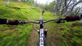
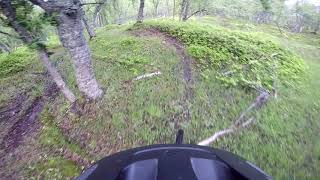
Popular Lyngseidet Mountain Biking Trails
• 90 ★ 4.9 • 1 mile • 79 ft • 58 •
Classic trail, with fantastic flow. The best option is to start with Trail and turn left on . Basically a blue trail until the narrow end section with some rocks and roots.
• 100 ★ 4.4 • 2,999 ft • 51 ft • 47 •
A few nice very berms finished off by a steep bananashape. After this the trail devide in three: , via 3 m or Gulruta.
• 55 ★ 3.9 • 4,636 ft • 5 ft • 35 •
Start riding down the same way as you came up. Cross the bridge and continue to your right. You will meet another trail but choose the one on your right and ride down to the road. Turn right and ride down to the hydropower station. You...
• 100 ★ 4.0 • 1,352 ft • 16 ft • 34 •
Fun Shapes! A challenging gap but quite easy for beginners in low speed also. A play with gravity. Going this using Traktorveien, and and you just did a lap. Once more? Proper built trail with just a few roots in the end.
• 75 ★ 5.0 • 2,385 ft • 14 ft • 31 •
With natural jumps and berms in beautiful forest this is one of our new favorites. Good also in wet conditions.
• 85 ★ 4.0 • 2,021 ft • 236 ft • 30 •
Turn left from at 180 m.a.s. start at with the T-cup where trail is closed by logs. Tip! Do another lap to try Ruta 40. This starts on Felix 100 m before . Look for a yellow drop sign.
• 85 ★ 5.0 • 1,896 ft • 2 ft • 30 •
Nice flow trail in the middle of the woods. There are three steep rollers in the trail, you might want to check these before first ride. Please be aware, at the end of the trail there is two sheep fences that you need to cross.
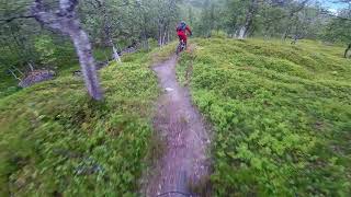
Photos of Lyngseidet Mountain Bike
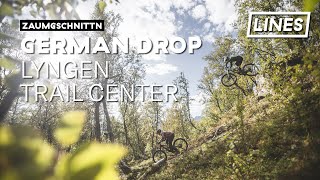
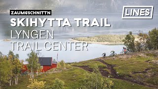
Videos of Lyngseidet Mountain Bike

trail: Rollercoaster
3:43 |
220 |
Aug 20, 2016
trail: Waterfall down
9:35 |
667 |
Jun 19, 2021 , Lyngseidet
trail: Gullruta
4:22 |
329 |
Jun 19, 2021 , Lyngseidet
youtuber
![Biken am Lyngenfjord | Lyngen Trail Center -...]()
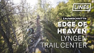
trail: Edge of Heaven
0:56 |
279 |
Jun 19, 2021 , Lyngseidet

trail: Edge of Heaven
2:41 |
364 |
Jun 19, 2021 , Lyngseidet
Recent Trail Reports
| status | trail | date | condition | info | user |
|---|---|---|---|---|---|
| Traktorveien | Jul 23, 2025 @ 8:42am Jul 23, 2025 | Ideal | moeldozer LTCB | ||
| Dead Dolly | Jul 13, 2025 @ 1:46am Jul 13, 2025 | Ideal | moeldozer LTCB | ||
| Felix Traverse | Jul 13, 2025 @ 1:41am Jul 13, 2025 | Ideal | moeldozer LTCB | ||
| Waterfall down | Jul 13, 2025 @ 1:41am Jul 13, 2025 | Ideal | moeldozer LTCB | ||
| Helmersen | Jul 13, 2025 @ 1:41am Jul 13, 2025 | Ideal | moeldozer LTCB | ||
| Edge of Heaven | Jul 13, 2025 @ 1:41am Jul 13, 2025 | Ideal | moeldozer LTCB | ||
| Sattareveien | Jul 13, 2025 @ 1:41am Jul 13, 2025 | Ideal | moeldozer LTCB | ||
| Fjellveien nedre | Jul 13, 2025 @ 1:41am Jul 13, 2025 | Ideal | moeldozer LTCB | ||
| Chaga | Jul 13, 2025 @ 1:41am Jul 13, 2025 | Ideal | moeldozer LTCB | ||
| Rollercoaster | Jul 13, 2025 @ 1:41am Jul 13, 2025 | Ideal | moeldozer LTCB |
Activity Feed
| username | action | type | title | date |
|---|---|---|---|---|
| moeldozer | add | poi | activity #97824056 | Jun 26, 2026 @ 3:47am 3 days |
| moeldozer | add | trail | activity #97823907 | Jun 26, 2026 @ 3:41am 3 days |
| moeldozer | update | trail | activity #97822955 and 5 more | Jun 26, 2026 @ 3:01am 3 days |
| LauricxkTQ9 | wishlist | trail | activity #97204529 | Jun 17, 2026 @ 12:53pm Jun 17, 2026 |
| Cykeljohan | update | trail | activity #92167265 and 1 more | Apr 8, 2026 @ 12:02am Apr 8, 2026 |
Recent Comments
| username | type | title | comment | date |
|---|---|---|---|---|
| trail | Pure gold super flow and fast trail. Love it | Jul 22, 2023 @ 12:31pm Jul 22, 2023 | ||
| trail | Beautiful trail! Rather steep and technical in... | Jul 21, 2022 @ 7:56am Jul 21, 2022 | ||
| trail | Fantastic trail! The upper crux near the... | Jun 27, 2022 @ 12:05am Jun 27, 2022 |
Local Badges
-

Completionist0 awarded -

Epic Mountain Bike Climb 2k3 awarded -

Climbing 10k Badge0 awarded -

Mountain Biking 100k Badge0 awarded -

Epic Ride Descent 2k3 awarded -

Descent 10k Badge0 awarded
Local Products
Activity Type Stats
| activitytype | trails | distance | descent | descent distance | total vertical | rating | global rank | state rank | photos | reports | routes | ridelogs |
|---|---|---|---|---|---|---|---|---|---|---|---|---|
| Mountain Bike | 41 | 31 miles | 8,606 ft | 13 miles | 3,819 ft | #2,673 | #28 | 53 | 67 | 432 | ||
| E-Bike | 38 | 24 miles | 8,346 ft | 12 miles | 1,936 ft | #2,738 | #36 | 1 | 65 | 52 | ||
| Hike | 38 | 33 miles | 6,378 ft | 11 miles | 3,848 ft | #4,131 | #44 | 47 | 362 | |||
| Trail Running | 37 | 33 miles | 6,378 ft | 11 miles | 3,848 ft | #3,735 | #45 | 47 | 26 | |||
| ATV/ORV/OHV | 1 | 1,093 ft | 164 ft | 12 | ||||||||
| Snowshoe | 2 | 5 miles | 404 ft | 2,789 ft | 3,481 ft | 14 | ||||||
| Downhill Ski | 1 | 2 miles | 3,281 ft | 13 | ||||||||
| Backcountry Ski | 3 | 7 miles | 30 ft | 577 ft | 4,124 ft | 1,240 |
Frequently Asked Questions About Lyngseidet
▼
What are the best places to ride in Lyngseidet?
Lyngseidet has 1 areas to explore for mountain biking. The top rated areas are:
▼
What are the highest rated mountain biking trails in Lyngseidet?
The highest rated mountain biking trails in Lyngseidet are:
- Gullruta (4.5/5)
- Dead Dolly (4.4/5)
- Edge of Heaven (4.4/5)
- Chaga (4.3/5)
- Rollercoaster (4.2/5)
▼
What is the best time of the year to ride in Lyngseidet?
Based on ride log data, the most popular months to ride in Lyngseidet are:
- June (14 activities)
- July (4 activities)
- October (4 activities)
▼
Where can I park to ride in Lyngseidet?
Activities
Trails
Points of Interest
- By valdovv & contributors
- Admins: maristam
- #39477 - 2,207 views
- lyngseidet activity log | embed map of Lyngseidet mountain bike trails | lyngseidet mountain biking points of interest
Downloading of trail gps tracks in kml & gpx formats is enabled for Lyngseidet.
You must login to download files.