close
-
Layers w
- Weather Layers
- Pro
- Pro
- Pro
- Pro
- Pro
- Pro
- More Layers
- Pro
- Pro
- Pro
- Pro
-
Upgrade to

3D
Trail Conditions
- Unknown
- Snow Groomed
- Snow Packed
- Snow Covered
- Snow Cover Partial
- Freeze/thaw Cycle
- Icy
- Prevalent Mud
- Wet
- Variable
- Ideal
- Dry
- Very Dry
Trail Flow (Ridden Direction)
Trailforks scans users ridelogs to determine the most popular direction each trail is ridden. A good flowing trail network will have most trails flowing in a single direction according to their intension.
The colour categories are based on what percentage of riders are riding a trail in its intended direction.
The colour categories are based on what percentage of riders are riding a trail in its intended direction.
- > 96%
- > 90%
- > 80%
- > 70%
- > 50%
- < 50%
- bi-directional trail
- no data
Trail Last Ridden
Trailforks scans ridelogs to determine the last time a trail was ridden.
- < 2 days
- < 1 week
- < 2 weeks
- < 1 month
- < 6 months
- > 6 months
Trail Ridden Direction
The intended direction a trail should be ridden.
- Downhill Only
- Downhill Primary
- Both Directions
- Uphill Primary
- Uphill Only
- One Direction
Contribute Details
Colors indicate trail is missing specified detail.
- Description
- Photos
- Description & Photos
- Videos
Trail Popularity ?
Trailforks scans ridelogs to determine which trails are ridden the most in the last 9 months.
Trails are compared with nearby trails in the same city region with a possible 25 colour shades.
Think of this as a heatmap, more rides = more kinetic energy = warmer colors.
- most popular
- popular
- less popular
- not popular
ATV/ORV/OHV Filter
Max Vehicle Width
inches
US Cell Coverage
Legend

Radar Time
Activity Recordings
Trailforks uses anonymized public activity data.
?
Activity Recordings
Trailforks uses anonymized public activity data.
?
Personal Heatmap
▶
Activity Types
all
/
none
▶
Options
2
Date range
month
–
Winter Trails
Warning
A routing network for winter maps does not exist. Selecting trails using the winter trails layer has been disabled.
Missing Trails
Most Popular
Least Popular
Trails are colored based on popularity. The more popular a trail is, the more red. Less popular trails trend towards green.
Jump Magnitude Heatmap
Heatmap of where riders jump on trails. Zoom in to see individual jumps, click circles to view jump details.
BC Backroad Status
![map legend]()
Service Road Atlas is a free to use, community-driven service for viewing and creating reports on the numerous back-country service roads around B.C. and Alberta.

Slope Aspect
Direction the slope faces
Trails Deemphasized
Trails are shown in grey.
Only show trails with no bike usage.
Suggested Layers
Based on selected activity type
Save the current map location and zoom level as your default home location whenever this page is loaded.
Save
No description for Macerata has been added yet!
Login or register to submit one.
This region uses the Uk/Euro style trail grading system.
Activities Click to view
- Mountain Bike
852 trails
- E-Bike
847 trails
- Horse
366 trails
- Hike
819 trails
- Trail Running
821 trails
- Dirtbike/Moto
467 trails
- Observed Trials
44 trails
- ATV/ORV/OHV
11 trails
- Downhill Ski
9 trails
- Nordic Ski
9 trails
Region Details
- 289
- 34
- 324
- 150
- 6
- 2
Stats
- Avg Trail Rating
- Trails (view details)
- 859
- Trails Mountain Bike
- 852
- Trails E-Bike
- 847
- Trails Horse
- 366
- Trails Hike
- 819
- Trails Trail Running
- 821
- Trails Dirtbike/Moto
- 467
- Trails Observed Trials
- 44
- Trails ATV/ORV/OHV
- 11
- Trails Snowmobile
- 2
- Trails Snowshoe
- 3
- Trails Downhill Ski
- 9
- Trails Backcountry Ski
- 2
- Trails Nordic Ski
- 9
- Total Distance
- 921 miles
- Total Descent Distance
- 449 miles
- Total Descent
- 249,073 ft
- Total Vertical
- 8,083 ft
- Highest Trailhead
- 8,083 ft
- Reports
- 1,362
- Photos
- 341
- Ridden Counter
- 10,924
Sub Regions
- Apiro (15)
- Caldarola (48)
- Camerino (47)
- Castelraimondo (14)
- Castelsantangelo Sul Nera (36)
- Cingoli (52)
- Cingoli trail park (41)
- Civitanova Marche (1)
- Esanatoglia (73)
- Fiastra (77)
- Fiuminata (7)
- Matelica (38)
- Monte Cavallo (25)
- Muccia (56)
- Pioraco (10)
- San Severino Marche (46)
- Sarnano (5)
- Sefro (17)
- Serrapetrona (11)
- Serravalle Del Chienti (57)
- Treia (34)
- Urbisaglia (34)
- Ussita (60)
- Valfornace (39)
- Visso (55)
Popular Macerata Mountain Biking Trails
• 100 ★ 3.0 • 4,865 ft • 0 ft • 116 •
A single-track in San Lorenzo, Treia. A stage of the enduro local race. Compact ground in first part, gravelly and rocky in the second.
• 100 ★ 3.4 • 1,286 ft • 0 ft • 100 •
is the fnal section of the Frontignano Bike Park's runs. It offers a funny northshore, big wooden ramps and an amazing wall ride. The structures can be bypassed by the beginners using a lateral steep but easy chicken line on the grass.
• 90 ★ 4.8 • 1 mile • 9 ft • 93 •
Popular black difficulty singletrack. This mountain bike primary trail can be used downhill only. It features jump, gap jump, rock face and rock garden. Trail visibility is always easy to follow. On average it takes 7 minutes to complete this trail.
• 85 ★ 4.0 • 1 mile • 0 ft • 92 •
Popular red difficulty singletrack. This mountain bike primary trail can be used downhill only and has a moderate overall physical rating. It features berm, jump and rock face. Trail visibility is always easy to follow. On average it takes 6 minutes to complete this trail.
• 95 ★ 4.2 • 1,516 ft • 0 ft • 91 •
Connection between and the last section of the Frontignano Bike Park. There are two funny wooden ramps on this speed straight section running half-coast on the open fields. The ramps have a chicken line.
• 75 ★ 4.0 • 3,048 ft • 0 ft • 87 •
hard to find, some gnarly steep sections with roots, a couple of turn are exposed and unprotected near the end.
• 85 ★ 4.7 • 2,372 ft • 0 ft • 86 •
is the most popular and flowy run of the Frontignano Bike Park. Very appreciated from the speed riders for its flow and wooden ramps. All the jumps have a chicken line. This is a lift-served run.
Macerata Mountain Bike Routes
★ 5.0 • 12 miles • 2,949 ft • 4 • Loop •
Anello enduro che sale per strade, carraie e forestali, e scende per le linee più ripide e dirette di...
★ 4.0 • 5 miles • 1,244 ft • 3 • Loop •
Toccata e fuga per provare le due piste storiche del Frontignano Bike Park. Sneak peek to the two main...
18 miles • 4,157 ft • 9 • Loop •
Cingoli Enduro Classic route, best trails in area. Not too hard rideable in every season. - Percorsi...
15 miles • 4,268 ft • 11 •
. . ..................................................................................................
15 miles • 2,979 ft • 4 • Loop •
1000 metri di dislivello in discesa, quasi interamente su single track e solo su discese classificate...
6 miles • 1,816 ft • 5 • Loop •
Questo itinerario ricompone antichi tratti di sentiero ed è adatto alle E-Bike, poiché la seconda parte...
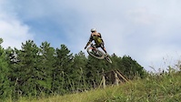
Photos of Macerata Mountain Bike
Videos of Macerata Mountain Bike
featured
![Frontignano Bike Park]()
trail: Pino Torto Reloaded
3:47 |
80 |
May 16, 2021
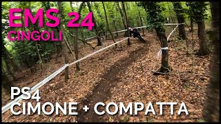
trail: Cimone
4:47 |
70 |
Sep 14, 2024 , Cingoli
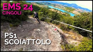
trail: Scoiattolo Discordia
3:45 |
101 |
Sep 14, 2024 , Cingoli
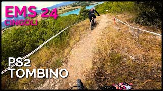
trail: Tombino
3:13 |
85 |
Sep 14, 2024 , Cingoli

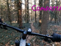
trail: Compatta
4:47 |
79 |
Sep 14, 2024 , Cingoli
trail: Esse trail
5:08 |
89 |
Sep 14, 2024 , Cingoli
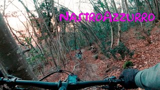
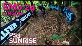
trail: Nastro Azzurro
5:22 |
158 |
Jan 5, 2024 , Cingoli
trail: Compatta
84 |
Jan 4, 2024 , Cingoli
Current Trail Warnings
| status | trail | date | condition | user | info |
|---|---|---|---|---|---|
| Pintura Di Bolognola to Rifugio Del Fargno Fiastra | Jun 6, 2026 @ 8:32pm (Europe/Rome) Jun 6, 2026 | Variable | fabioooo | la strada é percorribile, noi la abbiamo... | |
| Pintura To Rifugio Vallecaprina Sarnano | Jun 6, 2026 @ 8:28pm (Europe/Rome) Jun 6, 2026 | Unknown | fabioooo | alberi in mezzo alla strada portati da... | |
| Fosso di Salvazzano Camerino | May 21, 2026 @ 3:50pm (Europe/Rome) May 21, 2026 | Ideal | Smilzo80 |
Recent Trail Reports
Activity Feed
| username | action | type | title | date |
|---|---|---|---|---|
| Enricoclimb | add | report | activity #96987616 and 1 more | Jun 14, 2026 @ 11:04am Jun 14, 2026 |
| GIUSEPPEBORDONI38 | ridden | trail | activity #96697478 | Jun 10, 2026 @ 2:53pm Jun 10, 2026 |
| fabioooo | vote | trail | activity #96392132 | Jun 6, 2026 @ 11:35am Jun 6, 2026 |
| fabioooo | vote | trail | activity #96392097 | Jun 6, 2026 @ 11:34am Jun 6, 2026 |
| fabioooo | add | report | activity #96392086 | Jun 6, 2026 @ 11:34am Jun 6, 2026 |
Recent Comments
| username | type | title | comment | date |
|---|---|---|---|---|
| trail | Ein bisschen enttäuscht, eher ein sehr... | Sep 16, 2024 @ 9:29am Sep 16, 2024 | ||
| trail | Ciao, inserisci il commento come “trail... | Aug 27, 2024 @ 2:35pm Aug 27, 2024 | ||
| trail | Purtroppo molto scavato dalle piogge e un po'... | Aug 27, 2024 @ 10:11am Aug 27, 2024 | ||
| report | Praticamente chiuso purtroppo | Aug 4, 2024 @ 12:39pm Aug 4, 2024 | ||
| trail | Sentiero molto tecnico, anche questo come le... | Mar 24, 2024 @ 1:50pm Mar 24, 2024 |
Local Badges
-

Epic Ride 50k7 awarded -
Epic Ride 50k14 awarded -
Epic Ride 50k0 awarded -
Epic Ride 50k5 awarded -

Completionist0 awarded -
Completionist0 awarded
Bike & Skill Parks
| name | type | city | rating |
|---|---|---|---|
| Frontignano Bike Park | bike park | Ussita | |
| Crossdromo B. Tittoni (Cingoli) | skill park | Cingoli | |
| Esanatoglia | skill park | Esanatoglia |
Local Trail Supporters
![]()
- Hotel Felycita
![]()
![]()
![]()
Activity Type Stats
| activitytype | trails | distance | descent | descent distance | total vertical | rating | global rank | state rank | photos | reports | routes | ridelogs |
|---|---|---|---|---|---|---|---|---|---|---|---|---|
| Mountain Bike | 852 | 907 miles | 245,495 ft | 443 miles | 7,008 ft | 334 | 1,360 | 14 | 9,640 | |||
| E-Bike | 847 | 905 miles | 245,935 ft | 443 miles | 7,008 ft | 6 | 1,327 | 9 | 2,679 | |||
| Horse | 366 | 413 miles | 90,016 ft | 191 miles | 6,381 ft | 136 | 2 | |||||
| Hike | 819 | 890 miles | 229,393 ft | 424 miles | 8,084 ft | 1,179 | 3 | 750 | ||||
| Trail Running | 821 | 893 miles | 231,145 ft | 427 miles | 8,084 ft | 1,187 | 3 | 103 | ||||
| Dirtbike/Moto | 467 | 504 miles | 117,559 ft | 239 miles | 6,204 ft | 65 | ||||||
| Observed Trials | 44 | 28 miles | 4,380 ft | 12 miles | 5,377 ft | 1 | ||||||
| ATV/ORV/OHV | 11 | 16 miles | 1,125 ft | 3 miles | 4,797 ft | 45 | 1 | |||||
| Snowmobile | 2 | 3 miles | 26 ft | 768 ft | 1,378 ft | 2 | ||||||
| Snowshoe | 3 | 3 miles | 180 ft | 2,703 ft | 1,480 ft | 57 | 5 | |||||
| Downhill Ski | 9 | 11 miles | 2,201 ft | 7 miles | 1,503 ft | 54 | 54 | |||||
| Backcountry Ski | 2 | 4,554 ft | 180 ft | 2,703 ft | 1,480 ft | 53 | 58 | |||||
| Nordic Ski | 9 | 13 miles | 2,047 ft | 6 miles | 1,503 ft | 2 | 19 |
Frequently Asked Questions About Macerata
▼
What are the best places to ride in Macerata?
Macerata has 4 areas to explore for mountain biking. The top rated areas are:
▼
What are the highest rated mountain biking trails in Macerata?
The highest rated mountain biking trails in Macerata are:
- PS3 - Frontignano (4.3/5)
- DH Treia (4.3/5)
- Pino Torto Variante (4.3/5)
- Monte Coglia (4.2/5)
- Costa dell'Asino (4.2/5)
▼
What is the best time of the year to ride in Macerata?
Based on ride log data, the most popular months to ride in Macerata are:
- August (25 activities)
- July (20 activities)
- June (13 activities)
▼
What is the longest trail in Macerata?
The longest trail in Macerata is Parco Fluviale Del Chienti at 13.4 miles. View all trails sorted by distance.
Activities
Trails
- By denitopia
 TRAILFORKS VTA & contributors
 - Admins: denitopia, marcoangeletti, cemoorelife, rew187
- #11690 - 3,254 views
- macerata activity log | embed map of Macerata mountain bike trails | macerata mountain biking points of interest
Downloading of trail gps tracks in kml & gpx formats is enabled for Macerata.
You must login to download files.