close
-
Layers w
- Weather Layers
- Pro
- Pro
- Pro
- Pro
- Pro
- Pro
- More Layers
- Pro
- Pro
- Pro
- Pro
-
Upgrade to

3D
Trail Conditions
- Unknown
- Snow Groomed
- Snow Packed
- Snow Covered
- Snow Cover Partial
- Freeze/thaw Cycle
- Icy
- Prevalent Mud
- Wet
- Variable
- Ideal
- Dry
- Very Dry
Trail Flow (Ridden Direction)
Trailforks scans users ridelogs to determine the most popular direction each trail is ridden. A good flowing trail network will have most trails flowing in a single direction according to their intension.
The colour categories are based on what percentage of riders are riding a trail in its intended direction.
The colour categories are based on what percentage of riders are riding a trail in its intended direction.
- > 96%
- > 90%
- > 80%
- > 70%
- > 50%
- < 50%
- bi-directional trail
- no data
Trail Last Ridden
Trailforks scans ridelogs to determine the last time a trail was ridden.
- < 2 days
- < 1 week
- < 2 weeks
- < 1 month
- < 6 months
- > 6 months
Trail Ridden Direction
The intended direction a trail should be ridden.
- Downhill Only
- Downhill Primary
- Both Directions
- Uphill Primary
- Uphill Only
- One Direction
Contribute Details
Colors indicate trail is missing specified detail.
- Description
- Photos
- Description & Photos
- Videos
Trail Popularity ?
Trailforks scans ridelogs to determine which trails are ridden the most in the last 9 months.
Trails are compared with nearby trails in the same city region with a possible 25 colour shades.
Think of this as a heatmap, more rides = more kinetic energy = warmer colors.
- most popular
- popular
- less popular
- not popular
ATV/ORV/OHV Filter
Max Vehicle Width
inches
US Cell Coverage
Legend

Radar Time
Activity Recordings
Trailforks uses anonymized public activity data.
?
Activity Recordings
Trailforks uses anonymized public activity data.
?
Personal Heatmap
▶
Activity Types
all
/
none
▶
Options
2
Date range
month
–
Winter Trails
Warning
A routing network for winter maps does not exist. Selecting trails using the winter trails layer has been disabled.
Missing Trails
Most Popular
Least Popular
Trails are colored based on popularity. The more popular a trail is, the more red. Less popular trails trend towards green.
Jump Magnitude Heatmap
Heatmap of where riders jump on trails. Zoom in to see individual jumps, click circles to view jump details.
BC Backroad Status
![map legend]()
Service Road Atlas is a free to use, community-driven service for viewing and creating reports on the numerous back-country service roads around B.C. and Alberta.

Slope Aspect
Direction the slope faces
Trails Deemphasized
Trails are shown in grey.
Only show trails with no bike usage.
Suggested Layers
Based on selected activity type
Save the current map location and zoom level as your default home location whenever this page is loaded.
Save
No description for Macon has been added yet!
Login or register to submit one.
Activities Click to view
- Mountain Bike
51 trails
- E-Bike
48 trails
- Hike
75 trails
- Trail Running
75 trails
Region Details
- 7
- 27
- 15
Region Status
Open as of Apr 9, 2026Stats
- Avg Trail Rating
- Trails (view details)
- 49
- Trails Mountain Bike
- 51
- Trails E-Bike
- 48
- Trails Hike
- 75
- Trails Trail Running
- 75
- Total Distance
- 35 miles
- Total Descent Distance
- 11 miles
- Total Descent
- 2,353 ft
- Total Vertical
- 196 ft
- Highest Trailhead
- 482 ft
- Reports
- 179
- Photos
- 156
- Ridden Counter
- 2,938
Sub Regions
-
Arrowhead Park
- 7
- 9
-
Macon Children's Home
- 3
- 2
-
MGSU - Macon Campus
- 1
-
Ocmulgee Heritage Trail
- 10
-
Thomson Trails
- 2
- 5
Popular Macon Mountain Biking Trails
• 80 ★ 4.0 • 6 miles • 481 ft • 161 •
This is part of the 10 miles of Mountain Bike Trail, The main loop is 9 miles with 722 ft of elevation gain, 10 miles with the flow trail and there is a 5 mile loop that uses the center of the main loop. The terrain is intermediate with...
• 80 ★ 4.0 • 2 miles • 208 ft • 159 •
Popular blue difficulty singletrack. This multi-use trail can be used both directions. On average it takes 19 minutes to complete this trail.
• 75 ★ 4.0 • 4,695 ft • 133 ft • 150 •
Popular blue difficulty singletrack. This multi-use trail can be used one direction. On average it takes 12 minutes to complete this trail.
• 85 ★ 4.0 • 2,221 ft • 70 ft • 148 •
Popular blue difficulty singletrack. This multi-use trail can be used both directions. On average it takes 3 minutes to complete this trail.
• 100 ★ 4.5 • 4,829 ft • 74 ft • 105 •
Popular blue difficulty singletrack. This multi-use trail can be used both directions and has a moderate overall physical rating with a 74 ft blue climb. On average it takes 32 minutes to complete this trail.
• 95 ★ 3.0 • 1,811 ft • 0 ft • 88 •
Popular green difficulty singletrack. This multi-use trail can be used both directions. On average it takes 2 minutes to complete this trail.
• 85 ★ 3.7 • 1 mile • 75 ft • 77 •
machine cut flow trail with lots of little jumps and rollers
• 90 ★ 4.0 • 8 miles • 553 ft • 77 •
Nice little trail through the woods at the Georgia Industrial Children's Home. Mostly flat and a little bit bumpy in places with some roots and a few spots that are washed out a bit. Many many tight turns will have you testing your...
Macon Mountain Bike Routes
Thomson Full Black Loop Featured
★ 4.0 • 6 miles • 367 ft • 8 • Loop •
Thomson Black Loop. Follows the Black Arrows and its the entire trail system. Trail rating is actually...
Sandbox (Blue Loop) Featured
★ 5.0 • 4 miles • 248 ft • 5 • Loop •
Thomson Blue Loop. Follows the blue arrows
Pig Trail Yellow Loop Featured
5 miles • 251 ft • 3 •
Yellow Loop at Pig Trail. This route takes parts of the balck, blue, and green loops to make an enjoyable...
Thomson Black Loop Featured
5 miles • 306 ft • 9 • Loop •
The is the black loop minus Jake n Brake. This is kinda the OG black loop that most of the locals ride....
Green Loop Featured
★ 5.0 • 1 mile • 55 ft • 2 •
Green Loop @ Thomson. This is a 1 mile loop that is easy for beginners.
The Piggie Featured
12 miles • 592 ft • 7 • Loop •
This route incorporates the Green Loop with the and the entire Black Loop. This route starts off easy by...
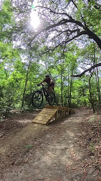
Photos of Macon Mountain Bike
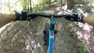
Videos of Macon Mountain Bike
trail: Sandbox #1
0:08 |
73 |
Jun 7, 2024

trail: Arrowhead West
39:56 |
378 |
Dec 14, 2020 , Macon

trail: Arrowhead Flow Trail
7:04 |
595 |
Oct 7, 2020 , Macon

trail: Arrowhead East
9:06 |
345 |
Oct 7, 2020 , Macon

trail: Sandbox #1
30:39 |
712 |
Sep 29, 2020 , Macon
trail: The Pig Trail
23:22 |
1258 |
Jan 30, 2018 , Macon
Recent Trail Reports
| status | trail | date | condition | info | user |
|---|---|---|---|---|---|
| Sandbox #1 | Apr 9, 2026 @ 6:06pm (America/New_York) Apr 9, 2026 | Ideal | MikeyMcBikey OMBA SORBA | ||
| Jake-N-Brake | Mar 18, 2026 @ 9:14pm (America/New_York) Mar 18, 2026 | Ideal | MikeyMcBikey OMBA SORBA | ||
| Brass Monkey | Oct 8, 2025 @ 8:19am (America/New_York) Oct 8, 2025 | Dry | tacobravo OMBA SORBA | ||
| Brass Monkey | Oct 8, 2025 @ 8:19am (America/New_York) Oct 8, 2025 | Dry | tacobravo OMBA SORBA | ||
| Radar Loop | Oct 8, 2025 @ 8:18am (America/New_York) Oct 8, 2025 | Dry | tacobravo OMBA SORBA | ||
| Sandbox #2 | Oct 8, 2025 @ 8:17am (America/New_York) Oct 8, 2025 | Dry | tacobravo OMBA SORBA | ||
| Sandbox #3 | Oct 8, 2025 @ 8:17am (America/New_York) Oct 8, 2025 | Dry | tacobravo OMBA SORBA | ||
| The Spiral | Oct 8, 2025 @ 8:16am (America/New_York) Oct 8, 2025 | Dry | tacobravo OMBA SORBA | ||
| Express Lane | Oct 8, 2025 @ 8:16am (America/New_York) Oct 8, 2025 | Dry | tacobravo OMBA SORBA | ||
| Ronnie's Way | Oct 8, 2025 @ 8:16am (America/New_York) Oct 8, 2025 | Dry | tacobravo OMBA SORBA |
Activity Feed
| username | action | type | title | date |
|---|---|---|---|---|
| MikeyMcBikey | add | report | activity #92281289 | Apr 9, 2026 @ 3:06pm Apr 9, 2026 |
| MikeyMcBikey | comment | report | activity #92281237 | Apr 9, 2026 @ 3:06pm Apr 9, 2026 |
| MikeyMcBikey | add | report | activity #92089976 | Apr 6, 2026 @ 5:43pm Apr 6, 2026 |
| tacobravo | add | trail | activity #92068332 | Apr 6, 2026 @ 11:45am Apr 6, 2026 |
| tacobravo | add | route | activity #92068105 and 1 more | Apr 6, 2026 @ 11:41am Apr 6, 2026 |
Recent Comments
| username | type | title | comment | date |
|---|---|---|---|---|
| report | Tree cleared | Apr 9, 2026 @ 3:06pm Apr 9, 2026 | ||
| trail | This trail is well maintained and is... | Sep 7, 2025 @ 8:39am Sep 7, 2025 | ||
| report | The as pm I’m Li was ohm. The one I am... | May 3, 2025 @ 10:42am May 3, 2025 | ||
| report | Tree has been cleared as of 1 Oct. | Oct 1, 2022 @ 6:18pm Oct 1, 2022 | ||
| trail | Fun fast trail in very nice condition. | Dec 2, 2021 @ 6:03pm Dec 2, 2021 |
Local Badges
-

Epic Mountain Bike Climb 2k4 awarded -

Climbing 10k Badge11 awarded -

Mountain Biking 100k Badge0 awarded -

Epic Ride Descent 2k4 awarded -

Descent 10k Badge11 awarded -

Descent 100k Badge0 awarded
Bike & Skill Parks
| name | type | city | rating |
|---|---|---|---|
| Echeconnee MX | skill park | Macon | |
| Thomson Dirt Jump Skill Area | skill park | Macon | |
| Arrowhead Skill Park | skill park | Macon |
Activity Type Stats
| activitytype | trails | distance | descent | descent distance | total vertical | rating | global rank | state rank | photos | reports | routes | ridelogs |
|---|---|---|---|---|---|---|---|---|---|---|---|---|
| Mountain Bike | 51 | 35 miles | 2,352 ft | 11 miles | 197 ft | #3,887 | #1,303 | 159 | 190 | 9 | 2,885 | |
| E-Bike | 48 | 33 miles | 2,221 ft | 10 miles | 197 ft | #3,067 | #1,125 | 149 | 12 | 195 | ||
| Hike | 75 | 33 miles | 2,162 ft | 10 miles | 197 ft | #1,283 | #587 | 202 | 1 | 135 | ||
| Trail Running | 75 | 33 miles | 2,162 ft | 10 miles | 197 ft | #4,093 | #1,245 | 202 | 1 | 75 |
Frequently Asked Questions About Macon
▼
What are the best places to ride in Macon?
Macon has 5 areas to explore for mountain biking. The top rated areas are:
▼
What are the highest rated mountain biking trails in Macon?
The highest rated mountain biking trails in Macon are:
- Sandbox #1 (4.1/5)
- The Pig Trail (4/5)
- Arrowhead West (4/5)
- Arrowhead East (4/5)
- Lake Climbs (4/5)
▼
What is the best time of the year to ride in Macon?
Based on ride log data, the most popular months to ride in Macon are:
- October (28 activities)
- September (25 activities)
- August (22 activities)
▼
Where can I park to ride in Macon?
There are 13 parking locations listed in Macon. The most popular parking spots are: View all parking and trailhead locations on the map to plan your visit.
Activities
Trails
- By WillieJacobsz
 Trailforks SBP SWW & contributors
 - Admins: apply
- #15071 - 6,922 views
- macon activity log | embed map of Macon mountain bike trails | macon mountain biking points of interest
Downloading of trail gps tracks in kml & gpx formats is enabled for Macon.
You must login to download files.