close
-
Layers w
- Weather Layers
- Pro
- Pro
- Pro
- Pro
- Pro
- Pro
- More Layers
- Pro
- Pro
- Pro
- Pro
-
Upgrade to

3D
Trail Conditions
- Unknown
- Snow Groomed
- Snow Packed
- Snow Covered
- Snow Cover Partial
- Freeze/thaw Cycle
- Icy
- Prevalent Mud
- Wet
- Variable
- Ideal
- Dry
- Very Dry
Trail Flow (Ridden Direction)
Trailforks scans users ridelogs to determine the most popular direction each trail is ridden. A good flowing trail network will have most trails flowing in a single direction according to their intension.
The colour categories are based on what percentage of riders are riding a trail in its intended direction.
The colour categories are based on what percentage of riders are riding a trail in its intended direction.
- > 96%
- > 90%
- > 80%
- > 70%
- > 50%
- < 50%
- bi-directional trail
- no data
Trail Last Ridden
Trailforks scans ridelogs to determine the last time a trail was ridden.
- < 2 days
- < 1 week
- < 2 weeks
- < 1 month
- < 6 months
- > 6 months
Trail Ridden Direction
The intended direction a trail should be ridden.
- Downhill Only
- Downhill Primary
- Both Directions
- Uphill Primary
- Uphill Only
- One Direction
Contribute Details
Colors indicate trail is missing specified detail.
- Description
- Photos
- Description & Photos
- Videos
Trail Popularity ?
Trailforks scans ridelogs to determine which trails are ridden the most in the last 9 months.
Trails are compared with nearby trails in the same city region with a possible 25 colour shades.
Think of this as a heatmap, more rides = more kinetic energy = warmer colors.
- most popular
- popular
- less popular
- not popular
ATV/ORV/OHV Filter
Max Vehicle Width
inches
US Cell Coverage
Legend

Radar Time
Activity Recordings
Trailforks uses anonymized public activity data.
?
Activity Recordings
Trailforks uses anonymized public activity data.
?
Personal Heatmap
▶
Activity Types
all
/
none
▶
Options
2
Date range
month
–
Winter Trails
Warning
A routing network for winter maps does not exist. Selecting trails using the winter trails layer has been disabled.
Missing Trails
Most Popular
Least Popular
Trails are colored based on popularity. The more popular a trail is, the more red. Less popular trails trend towards green.
Jump Magnitude Heatmap
Heatmap of where riders jump on trails. Zoom in to see individual jumps, click circles to view jump details.
BC Backroad Status
![map legend]()
Service Road Atlas is a free to use, community-driven service for viewing and creating reports on the numerous back-country service roads around B.C. and Alberta.

Slope Aspect
Direction the slope faces
Trails Deemphasized
Trails are shown in grey.
Only show trails with no bike usage.
Suggested Layers
Based on selected activity type
Save the current map location and zoom level as your default home location whenever this page is loaded.
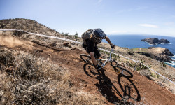
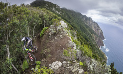
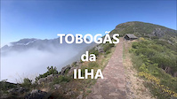
SaveIlha de origem vulcânica muito montanhosa, ideal para os Riders de BTT, tem trilhos descendentes a começar nos 1800 metros até ao nível do mar, muitos trilhos pela ilha toda com todo o tipo de terreno para a vertente do BTT, desde o fácil ao mais hardcore, desde aberto a florestas de vegetação densas, tem perto de 6 firmas de passeios de btt, que fazem a elevação dos Riders ao topo das montanhas em carrinhas. È um paraiso. Fora poo BTT á muito para desfrutar na Ilha.
AKA: Perola do Atlantico
Links
This region uses the Uk/Euro style trail grading system.
Activities Click to view
- Mountain Bike
36 trails
- E-Bike
10 trails
- Gravel Bike
0 trails
- Adaptive Bike
0 trails
- Winter Fat Bike
0 trails
- Hike
38 trails
- Trail Running
35 trails
Region Details
- 2
- 1
- 14
- 15
- 4
Region Status
Caution as of Jun 1, 2026Stats
- Avg Trail Rating
- Trails (view details)
- 46
- Trails Mountain Bike
- 36
- Trails E-Bike
- 10
- Trails Hike
- 38
- Trails Trail Running
- 35
- Total Distance
- 65 miles
- Total Descent
- 49,531 ft
- Total Vertical
- 5,659 ft
- Highest Trailhead
- 5,710 ft
- Reports
- 701
- Photos
- 1,534
- Ridden Counter
- 14,478
Articles
Race Report: Trans Madeira Summer 2026 - Days 5 & 6
May 25, 2026 from pinkbike.com
6 days, 35 blind stages, and an island-hopping finale. German elites sweep the overall titles as the gruelling multi-day gauntlet wraps up on the...
Mud, Dust, & 'Gamble': Trans Madeira Delivers Epic Contrast in First Two Days
May 20, 2026 from pinkbike.com
From a Day 1 mud bath to racing above the clouds on Day 2, German elites Christian Textor and Helen Weber open up massive gaps in the Atlantic.
Race Report: Trans Madeira Autumn 2025 - Days 6
Sep 30, 2025 from pinkbike.com
Race Report: Trans Madeira Autumn 2025 - Days 1 & 2
Sep 24, 2025 from pinkbike.com
Thirteen editions later, the excitement remains as fresh as day one.
Sub Regions
-
Porto Santo
- 4
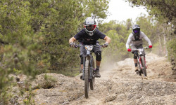
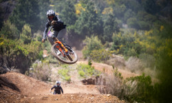
Popular Madeira Mountain Biking Trails
• 100 ★ 4.4 • 2,287 ft • 24 ft • 1,050 •
Primeira parte do Trilho enquadrado nas Zonas Altas do Funchal - São Roque, depois entramos nas arvores de eucaliptos, tem que ir pelo trilho sempre há direita. Trilho longo e um pouco puxado fisicamente, parte inicial com muitos Rock...
• 100 ★ 4.0 • 1,617 ft • 3 ft • 558 •
Primeira parte do Trilho enquadrado nas Zonas Altas do Funchal - São Roque, depois entramos nas arvores de eucaliptos, tem que ir pelo trilho sempre há direita. Trilho longo e um pouco puxado fisicamente, parte inicial com muitos Rock...
• 95 ★ 4.0 • 1,289 ft • 3 ft • 544 •
Segunda parte do Trilho enquadrado nas Zonas Altas do Funchal - São Roque, depois entramos nas arvores de eucaliptos, tem que ir pelo trilho sempre há direita. Trilho longo e um pouco puxado fisicamente, parte inicial com muitos Rock...
• 95 ★ 4.2 • 1 mile • 9 ft • 427 •
Começa por pedal numa levada, cerca de 2.5 km, depois temos muitas passadas para descer, nível Hard, muito inclinadas e quando molhadas, perigosas, aconselho a levar a bike na mão nas passadas mais agressivas, depois tem mais um...
• 90 ★ 4.4 • 1 mile • 4 ft • 312 •
Probably the most beautiful alpine trail on the island, with magnificent views. The trail is also very good, with a difficulty level suitable for average to experienced riders.
• 90 ★ 4.8 • 1 mile • 15 ft • 258 •
Pista muito inclinada, técnica, piso de terra e raízes, varios drop ao longo do trilho de nivel Hard. Pista de prova DH na Ilha da Madeira. Passeio divertido, é vir do trilho de crosscountry da Bica da Cana até os Estanquinhos,...
• 80 ★ 0.0 • 4,862 ft • 0 ft • 77 •
Popular blue difficulty singletrack. This mountain bike primary trail can be used downhill only. It features berm.
Madeira Mountain Bike Routes
★ 5.0 • 10 miles • 239 ft • 8 • Point to Point •
Começando no Pico do Arieiro para acabar no Funchal, pouco pedal, muita descida, com bike de DH vai bem...
★ 5.0 • 17 miles • 3,691 ft • 9 • Point to Point •
LIGAÇÃO 1 Saída das lareiras ao pé da champery entrar no estradão por baixo da pista de motocross e...
★ 5.0 • 20 miles • 2,142 ft • 11 • Point to Point •
Muito puxado fisicamente, muita descida, muito pedal em plano e pouca subida, vários níveis técnicos ao...
10 miles • 2,052 ft • 4 •
Desde o Portão Norte do Chão da Lagoa até à Adega do Paraíso. Com passagem pelo parque ecológico,...
★ 2.0 • 23 miles • 2,900 ft • 8 • Point to Point •
Team Carqueja Bike Trip through the various trails near Funchal
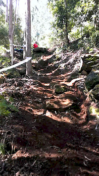
Photos of Madeira Mountain Bike
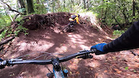
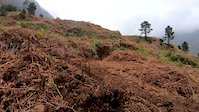
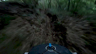
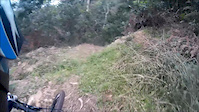
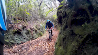
Videos of Madeira Mountain Bike
trail: Folhadal - Rosário
2:21 |
92 |
Jun 6, 2022

trail: Estaca Trail 1
6:48 |
286 |
Feb 15, 2022
trail: lha Trail PR1
7:03 |
1002 |
Jul 1, 2020
trail: Lombo's track
0:07 |
64 |
Feb 27, 2020
trail: Folhadal - Rosário
4:41 |
109 |
Dec 28, 2019
trail: Ginjas
0:08 |
210 |
May 24, 2016
trail: Parque empresarial Santana
2:21 |
81 |
Dec 21, 2015
trail: Pista dos Cedros
3:50 |
171 |
Dec 21, 2015
Recent Trail Reports
| status | trail | date | condition | info | user |
|---|---|---|---|---|---|
| Lambe Lambe | May 23, 2026 @ 1:56pm (Atlantic/Madeira) May 23, 2026 | Ideal | Reonaydo | ||
| Estaca Trail 3 | Apr 30, 2026 @ 9:42am (Atlantic/Madeira) Apr 30, 2026 | Ideal | montogeek | ||
| Estaca Trail 2 | Apr 30, 2026 @ 9:42am (Atlantic/Madeira) Apr 30, 2026 | Ideal | montogeek | ||
| Estaca Trail 1 | Apr 30, 2026 @ 9:42am (Atlantic/Madeira) Apr 30, 2026 | Ideal | montogeek | ||
| Folhadal - Rosário | Apr 18, 2026 @ 10:31am (Atlantic/Madeira) Apr 18, 2026 | Wet | architrepa TFSPAIN | ||
| Pico do Cedro | Feb 10, 2026 @ 2:31pm (Atlantic/Madeira) Feb 10, 2026 | Dry | OdysseyMTB | ||
| Caminho Real da Encumeada | Jan 14, 2026 @ 7:21pm (Europe/Lisbon) Jan 14, 2026 | Unknown | amcclaran | ||
| Bica da Cana / Chão das Poças | Oct 12, 2025 @ 6:23pm (Europe/Lisbon) Oct 12, 2025 | Wet | noisyriver | ||
| Ginjas | Oct 12, 2025 @ 6:16pm (Europe/Lisbon) Oct 12, 2025 | Dry | noisyriver | ||
| Pista da Canoa | Apr 18, 2025 @ 3:54am Apr 18, 2025 | Ideal | SEE5dM |
Activity Feed
| username | action | type | title | date |
|---|---|---|---|---|
| trailforks | add | article_links | activity #95523310 | May 25, 2026 @ 2:23pm May 25, 2026 |
| dfreihofner | ridden | trail | activity #95352863 and 1 more | May 23, 2026 @ 1:57pm May 23, 2026 |
| Reonaydo | add | report | activity #95320488 | May 23, 2026 @ 8:21am May 23, 2026 |
| dfreihofner | ridden | trail | activity #95241446 and 1 more | May 22, 2026 @ 7:38am May 22, 2026 |
| muerte | ridden | trail | activity #95155468 | May 20, 2026 @ 9:42pm May 20, 2026 |
Recent Comments
| username | type | title | comment | date |
|---|---|---|---|---|
| report | first bit nearly unrideable stairs, then a... | Apr 20, 2026 @ 11:02am Apr 20, 2026 | ||
| trail | Top trail! | Aug 20, 2025 @ 12:04am Aug 20, 2025 | ||
| report | It's fantastic for the last 2 to 3 kilometers.... | Jan 25, 2025 @ 1:52am Jan 25, 2025 | ||
| trail | recomendo, tinha merda e um rato morto na... | Oct 14, 2024 @ 5:00am Oct 14, 2024 | ||
| trail | Our favorite trail ridden in Madeira! Great... | Jan 23, 2024 @ 6:11pm Jan 23, 2024 |
Local Badges
-

10 Blue Trails259 awarded -

10 Black Trails10 awarded -

Epic Ride Climb 2k1,269 awarded -

Climbing 10k Badge178 awarded -

Climbing 100k Badge6 awarded -

Epic Ride Descent 2k2,380 awarded
Bike & Skill Parks
| name | type | city | rating |
|---|---|---|---|
| Bike Park Porto Moniz | skill park | Madeira | |
| Skate/BMX Park Agua de Pena | skill park | Madeira | |
| Skatepark do Funchal | skill park | Madeira |
Activity Type Stats
| activitytype | trails | distance | descent | descent distance | total vertical | rating | global rank | state rank | photos | reports | routes | ridelogs |
|---|---|---|---|---|---|---|---|---|---|---|---|---|
| Mountain Bike | 36 | 45 miles | 39,938 ft | 34 miles | 5,659 ft | #1,157 | #4 | 1,506 | 672 | 15 | 8,056 | |
| E-Bike | 10 | 7 miles | 5,377 ft | 6 miles | 4,304 ft | #1,264 | #12 | 609 | 2 | 307 | ||
| Hike | 38 | 61 miles | 46,053 ft | 40 miles | 5,482 ft | #359 | #3 | 28 | 637 | 1,294 | ||
| Trail Running | 35 | 50 miles | 44,236 ft | 37 miles | 5,482 ft | #996 | #2 | 638 | 64 |
Frequently Asked Questions About Madeira
▼
What are the best places to ride in Madeira?
Madeira has 1 areas to explore for mountain biking. The top rated areas are:
▼
What are the highest rated mountain biking trails in Madeira?
The highest rated mountain biking trails in Madeira are:
- Ginjas (4.4/5)
- Antenas (4.3/5)
- Kanga (4.3/5)
- Caminho Real da Encumeada (4.3/5)
- Estaca Trail 1 (4.2/5)
▼
What is the best time of the year to ride in Madeira?
Based on ride log data, the most popular months to ride in Madeira are:
- November (45 activities)
- September (36 activities)
- October (25 activities)
▼
Where can I park to ride in Madeira?
There are 1 parking locations listed in Madeira. The most popular parking spots are:
Activities
Trails
Points of Interest
- By cyt59 & contributors
- Admins: elyari, AMG, marcossantamaria, bikulture, ATBM
- #4111 - 76,706 views
- madeira activity log | embed map of Madeira mountain bike trails | madeira mountain biking points of interest
Downloading of trail gps tracks in kml & gpx formats is enabled for Madeira.
You must login to download files.