close
-
Layers w
- Weather Layers
- Pro
- Pro
- Pro
- Pro
- Pro
- Pro
- More Layers
- Pro
- Pro
- Pro
- Pro
-
Upgrade to

3D
Trail Conditions
- Unknown
- Snow Groomed
- Snow Packed
- Snow Covered
- Snow Cover Partial
- Freeze/thaw Cycle
- Icy
- Prevalent Mud
- Wet
- Variable
- Ideal
- Dry
- Very Dry
Trail Flow (Ridden Direction)
Trailforks scans users ridelogs to determine the most popular direction each trail is ridden. A good flowing trail network will have most trails flowing in a single direction according to their intension.
The colour categories are based on what percentage of riders are riding a trail in its intended direction.
The colour categories are based on what percentage of riders are riding a trail in its intended direction.
- > 96%
- > 90%
- > 80%
- > 70%
- > 50%
- < 50%
- bi-directional trail
- no data
Trail Last Ridden
Trailforks scans ridelogs to determine the last time a trail was ridden.
- < 2 days
- < 1 week
- < 2 weeks
- < 1 month
- < 6 months
- > 6 months
Trail Ridden Direction
The intended direction a trail should be ridden.
- Downhill Only
- Downhill Primary
- Both Directions
- Uphill Primary
- Uphill Only
- One Direction
Contribute Details
Colors indicate trail is missing specified detail.
- Description
- Photos
- Description & Photos
- Videos
Trail Popularity ?
Trailforks scans ridelogs to determine which trails are ridden the most in the last 9 months.
Trails are compared with nearby trails in the same city region with a possible 25 colour shades.
Think of this as a heatmap, more rides = more kinetic energy = warmer colors.
- most popular
- popular
- less popular
- not popular
ATV/ORV/OHV Filter
Max Vehicle Width
inches
US Cell Coverage
Legend

Radar Time
Activity Recordings
Trailforks uses anonymized public activity data.
?
Activity Recordings
Trailforks uses anonymized public activity data.
?
Personal Heatmap
▶
Activity Types
all
/
none
▶
Options
2
Date range
month
–
Winter Trails
Warning
A routing network for winter maps does not exist. Selecting trails using the winter trails layer has been disabled.
Missing Trails
Most Popular
Least Popular
Trails are colored based on popularity. The more popular a trail is, the more red. Less popular trails trend towards green.
Jump Magnitude Heatmap
Heatmap of where riders jump on trails. Zoom in to see individual jumps, click circles to view jump details.
BC Backroad Status
![map legend]()
Service Road Atlas is a free to use, community-driven service for viewing and creating reports on the numerous back-country service roads around B.C. and Alberta.

Slope Aspect
Direction the slope faces
Trails Deemphasized
Trails are shown in grey.
Only show trails with no bike usage.
Suggested Layers
Based on selected activity type
Save the current map location and zoom level as your default home location whenever this page is loaded.
Save
No description for Maidstone has been added yet!
Login or register to submit one.
This region uses the Uk/Euro style trail grading system.
Activities Click to view
- Mountain Bike
25 trails
- E-Bike
3 trails
- Gravel Bike
0 trails
- Adaptive Bike
0 trails
- Winter Fat Bike
0 trails
- Horse
0 trails
- Hike
25 trails
- Trail Running
25 trails
Region Details
- 10
- 9
- 1
- 1
Region Status
Caution as of 2 daysStats
- Avg Trail Rating
- Trails (view details)
- 25
- Trails Mountain Bike
- 25
- Trails E-Bike
- 3
- Trails Hike
- 25
- Trails Trail Running
- 25
- Total Distance
- 12 miles
- Total Descent
- 4,238 ft
- Total Vertical
- 623 ft
- Highest Trailhead
- 638 ft
- Reports
- 192
- Photos
- 41
- Ridden Counter
- 2,366
Sub Regions
-
Little Monk Wood
Popular Maidstone Mountain Biking Trails
• 100 ★ 4.0 • 1 mile • 114 ft • 144 •
Popular green difficulty singletrack. This multi-use trail can be used both directions. On average it takes 8 minutes to complete this trail.
• 95 ★ 4.7 • 3,523 ft • 71 ft • 104 •
Popular blue difficulty singletrack. This mountain bike primary trail can be used both directions. On average it takes 4 minutes to complete this trail.
• 70 ★ 4.0 • 720 ft • 0 ft • 87 •
Head towards the gully in front of you, but turn right then drop into the gully further down, so you ride down the gully, get it? Good!
• 90 ★ 4.0 • 3,023 ft • 54 ft • 83 •
Popular blue difficulty singletrack. This mountain bike primary trail can be used both directions. It features drop, jump and gap jump. On average it takes 6 minutes to complete this trail.
• 60 ★ 4.7 • 2,671 ft • 51 ft • 79 •
Moderately popular red difficulty singletrack. This mountain bike primary trail can be used both directions. On average it takes 5 minutes to complete this trail.
• 55 ★ 4.5 • 1,297 ft • 11 ft • 77 •
Moderately popular blue difficulty singletrack. This mountain bike primary trail can be used both directions. It features berm, drop, jump and gap jump. On average it takes 3 minutes to complete this trail.
• 75 ★ 5.0 • 2,680 ft • 53 ft • 76 •
Nice forest trail, quite easy with the biggest challenge being navigation between trees and branches
• 40 ★ 3.0 • 3,415 ft • 10 ft • 61 • • hike
Moderately popular green difficulty family friendly singletrack. This hike primary trail can be used both directions. On average it takes 3 minutes to complete this trail.
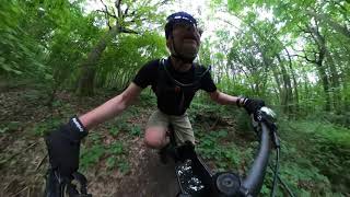
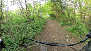
Photos of Maidstone Mountain Bike
Videos of Maidstone Mountain Bike
trail: John the Log Dropper
15:33 |
389 |
Jul 3, 2021 , Maidstone
trail: Monkey Breath
16:52 |
630 |
Jun 30, 2021 , Maidstone
Recent Trail Reports
| status | trail | date | condition | info | user |
|---|---|---|---|---|---|
| John the Log Dropper | Jun 24, 2024 @ 11:16am Jun 24, 2024 | Ideal | Urbanlung | ||
| Inferno | Nov 19, 2022 @ 11:01am Nov 19, 2022 | Variable | daverallye | ||
| North Downs Way | Oct 11, 2022 @ 8:00am Oct 11, 2022 | Ideal | HuggyHotspur | ||
| Peppermint Rush | Sep 7, 2021 @ 11:13am Sep 7, 2021 | Variable | Urbanlung | ||
| Lost & Found | Jul 27, 2021 @ 12:11am Jul 27, 2021 | Wet | owen6116 | ||
| Django | Jul 22, 2021 @ 8:49am Jul 22, 2021 | Ideal | Poggs38 | ||
| Double Flush | Jul 22, 2021 @ 8:49am Jul 22, 2021 | Ideal | Poggs38 | ||
| Run Rabbit Run | Apr 30, 2021 @ 1:42am Apr 30, 2021 | Dry | YTJeffsy2018 | ||
| Banana Ridge | Apr 25, 2021 @ 3:28am Apr 25, 2021 | Dry | MartinG5000 | ||
| Dave's Descent | Apr 4, 2021 @ 3:43am Apr 4, 2021 | Dry | YTJeffsy2018 |
Activity Feed
| username | action | type | title | date |
|---|---|---|---|---|
| Daniel5dbN1z | difficultyvote | trail | activity #92664807 | Apr 15, 2026 @ 9:16am Apr 15, 2026 |
| Sam2KbgxD | ridden | trail | activity #82933223 | Oct 24, 2025 @ 11:06am Oct 24, 2025 |
| Sunandstella | ridden | trail | activity #79868125 | Sep 7, 2025 @ 1:20pm Sep 7, 2025 |
| NyssaiKy4Z2 | ridden | trail | activity #76163233 | Jul 18, 2025 @ 9:33am Jul 18, 2025 |
| jamiesTQKvA | wishlist | trail | activity #75540816 | Jul 9, 2025 @ 11:57am Jul 9, 2025 |
Recent Comments
| username | type | title | comment | date |
|---|---|---|---|---|
| trail | I got lost in the woodland here trying to find... | Feb 1, 2023 @ 4:27am Feb 1, 2023 | ||
| trail | Boggy swamp trail today this one! | Dec 6, 2020 @ 9:20am Dec 6, 2020 | ||
| trail | Rode today very muddy and greasy | Dec 5, 2020 @ 2:03pm Dec 5, 2020 | ||
| trail | Muddy, quite flat, some wooden steps midway is... | Nov 29, 2020 @ 4:37am Nov 29, 2020 | ||
| report | Wet | Nov 2, 2020 @ 8:03am Nov 2, 2020 |
Local Badges
-

10 Blue Trails56 awarded -

Epic Ride Climb 2k7 awarded -

Climbing 10k Badge34 awarded -

Climbing 100k Badge0 awarded -

Epic Ride Descent 2k7 awarded -

Descent 10k Badge35 awarded
Activity Type Stats
| activitytype | trails | distance | descent | descent distance | total vertical | rating | global rank | state rank | photos | reports | routes | ridelogs |
|---|---|---|---|---|---|---|---|---|---|---|---|---|
| Mountain Bike | 25 | 12 miles | 4,239 ft | 8 miles | 623 ft | #2,900 | #94 | 41 | 192 | 5,832 | ||
| E-Bike | 3 | 1 mile | 256 ft | 3,360 ft | 623 ft | #4,650 | #190 | 133 | 1,255 | |||
| Hike | 25 | 12 miles | 4,239 ft | 8 miles | 623 ft | #6,100 | #150 | 192 | 120 | |||
| Trail Running | 25 | 12 miles | 4,239 ft | 8 miles | 623 ft | #5,651 | #142 | 192 | 117 |
Frequently Asked Questions About Maidstone
▼
What are the best places to ride in Maidstone?
Maidstone has 1 areas to explore for mountain biking.
▼
What are the highest rated mountain biking trails in Maidstone?
The highest rated mountain biking trails in Maidstone are:
- John the Log Dropper (4.2/5)
- Monkey Breath (4.2/5)
- Dave's Descent (4.2/5)
- Lost & Found (4.1/5)
- Hell's Staircase (4.1/5)
▼
What is the best time of the year to ride in Maidstone?
Based on ride log data, the most popular months to ride in Maidstone are:
- July (84 activities)
- June (63 activities)
- August (58 activities)
▼
Where can I park to ride in Maidstone?
Check the Maidstone trail map for trailhead and parking information. Community members regularly update access and parking details for trails in the area.
- By mat-g
 & contributors
 - Admins: wisey, MathieuC, cemoorelife
- #5392 - 10,687 views
- maidstone activity log | embed map of Maidstone mountain bike trails |
Downloading of trail gps tracks in kml & gpx formats is enabled for Maidstone.
You must login to download files.