close
-
Layers w
- Weather Layers
- Pro
- Pro
- Pro
- Pro
- Pro
- Pro
- More Layers
- Pro
- Pro
- Pro
- Pro
-
Upgrade to

3D
Trail Conditions
- Unknown
- Snow Groomed
- Snow Packed
- Snow Covered
- Snow Cover Partial
- Freeze/thaw Cycle
- Icy
- Prevalent Mud
- Wet
- Variable
- Ideal
- Dry
- Very Dry
Trail Flow (Ridden Direction)
Trailforks scans users ridelogs to determine the most popular direction each trail is ridden. A good flowing trail network will have most trails flowing in a single direction according to their intension.
The colour categories are based on what percentage of riders are riding a trail in its intended direction.
The colour categories are based on what percentage of riders are riding a trail in its intended direction.
- > 96%
- > 90%
- > 80%
- > 70%
- > 50%
- < 50%
- bi-directional trail
- no data
Trail Last Ridden
Trailforks scans ridelogs to determine the last time a trail was ridden.
- < 2 days
- < 1 week
- < 2 weeks
- < 1 month
- < 6 months
- > 6 months
Trail Ridden Direction
The intended direction a trail should be ridden.
- Downhill Only
- Downhill Primary
- Both Directions
- Uphill Primary
- Uphill Only
- One Direction
Contribute Details
Colors indicate trail is missing specified detail.
- Description
- Photos
- Description & Photos
- Videos
Trail Popularity ?
Trailforks scans ridelogs to determine which trails are ridden the most in the last 9 months.
Trails are compared with nearby trails in the same city region with a possible 25 colour shades.
Think of this as a heatmap, more rides = more kinetic energy = warmer colors.
- most popular
- popular
- less popular
- not popular
ATV/ORV/OHV Filter
Max Vehicle Width
inches
US Cell Coverage
Legend

Radar Time
Activity Recordings
Trailforks uses anonymized public activity data.
?
Activity Recordings
Trailforks uses anonymized public activity data.
?
Personal Heatmap
▶
Activity Types
all
/
none
▶
Options
2
Date range
month
–
Winter Trails
Warning
A routing network for winter maps does not exist. Selecting trails using the winter trails layer has been disabled.
Missing Trails
Most Popular
Least Popular
Trails are colored based on popularity. The more popular a trail is, the more red. Less popular trails trend towards green.
Jump Magnitude Heatmap
Heatmap of where riders jump on trails. Zoom in to see individual jumps, click circles to view jump details.
BC Backroad Status
![map legend]()
Service Road Atlas is a free to use, community-driven service for viewing and creating reports on the numerous back-country service roads around B.C. and Alberta.

Slope Aspect
Direction the slope faces
Trails Deemphasized
Trails are shown in grey.
Only show trails with no bike usage.
Suggested Layers
Based on selected activity type
Save the current map location and zoom level as your default home location whenever this page is loaded.
Save
No description for Maniago has been added yet!
Login or register to submit one.
This region uses the Uk/Euro style trail grading system.
Activities Click to view
- Mountain Bike
52 trails
- E-Bike
2 trails
- Gravel Bike
0 trails
- Adaptive Bike
0 trails
- Winter Fat Bike
0 trails
- Hike
52 trails
- Trail Running
52 trails
Region Details
- 10
- 10
- 27
- 3
- 1
Region Status
Open as of May 16, 2026Stats
- Avg Trail Rating
- Trails (view details)
- 52
- Trails Mountain Bike
- 52
- Trails E-Bike
- 2
- Trails Hike
- 52
- Trails Trail Running
- 52
- Total Distance
- 47 miles
- Total Descent
- 24,483 ft
- Total Vertical
- 4,195 ft
- Highest Trailhead
- 5,158 ft
- Reports
- 312
- Photos
- 56
- Ridden Counter
- 2,187
Sub Regions
-
Monte Fara
- 2
- 2
- 1
-
Monte Jouf
- 8
- 21
- 3
Popular Maniago Mountain Biking Trails
• 95 ★ 4.7 • 2,704 ft • 3 ft • 138 •
The masterpiece! Berms, rocks, swichbacks and flow. Enjoy!
• 80 ★ 4.5 • 2,482 ft • 10 ft • 84 •
Popular blue difficulty singletrack. This mountain bike primary trail can be used downhill primary and has a moderate overall physical rating. It features berm, drop and jump. On average it takes 5 minutes to complete this trail.
• 85 ★ 5.0 • 4,020 ft • 114 ft • 78 •
Beautiful am-enduro trail with tech stuff, high speed flow sections, hand shaped berms and jumps.
• 50 ★ 4.0 • 873 ft • 0 ft • 74 •
Moderately popular blue difficulty singletrack. This mountain bike primary trail can be used downhill only. On average it takes 3 minutes to complete this trail.
• 100 ★ 4.7 • 2,712 ft • 17 ft • 72 •
Popular blue difficulty singletrack. This mountain bike primary trail can be used downhill primary and has a moderate overall physical rating. It features berm. On average it takes 5 minutes to complete this trail.
• 75 ★ 4.5 • 3,968 ft • 6 ft • 62 •
Popular red difficulty singletrack. This mountain bike primary trail can be used downhill only and has a moderate overall physical rating. It features berm and jump. On average it takes 4 minutes to complete this trail.
• 65 ★ 4.0 • 1,495 ft • 0 ft • 55 •
Moderately popular blue difficulty alpine singletrack. This mountain bike primary trail can be used downhill primary and has a moderate overall physical rating. On average it takes 2 minutes to complete this trail.
• 55 ★ 3.5 • 1,686 ft • 16 ft • 54 •
Moderately popular blue difficulty alpine singletrack. This mountain bike primary trail can be used downhill only and has a easy overall physical rating. On average it takes 2 minutes to complete this trail.
Maniago Mountain Bike Routes
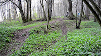
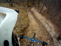
Photos of Maniago Mountain Bike
Videos of Maniago Mountain Bike
trail: New
0:06 |
309 |
May 4, 2014
trail: Kraken
3:29 |
764 |
Jan 12, 2014
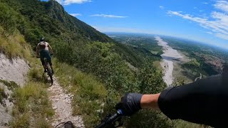
trail: Panorama Trail
11:06 |
92 |
Aug 11, 2025 , Maniago

trail: North Side Trail
11:06 |
68 |
Aug 11, 2025 , Maniago
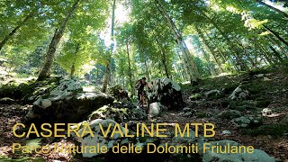
trail: Casera Valine Di Selva
11:05 |
342 |
Jul 7, 2022 , Maniago
trail: North Side Trail
5:18 |
747 |
Oct 15, 2019 , Maniago
Recent Trail Reports
| status | trail | date | condition | info | user |
|---|---|---|---|---|---|
| Da Piazzale Jouf a Croce | May 16, 2026 @ 10:27am (Europe/Rome) May 16, 2026 | Ideal | Articolo18 | ||
| Orcolat 300/2 (parte bassa) | Mar 6, 2026 @ 9:09am (Europe/Rome) Mar 6, 2026 | Ideal | Maurozanier | ||
| Tagliafuoco valpiccola | Mar 6, 2026 @ 9:09am (Europe/Rome) Mar 6, 2026 | Dry | Maurozanier | ||
| verso Ravedis | Mar 6, 2026 @ 9:09am (Europe/Rome) Mar 6, 2026 | Dry | Maurozanier | ||
| Mithril | Dec 14, 2025 @ 7:00am (Europe/Rome) Dec 13, 2025 | Ideal | kakkio70 | ||
| Da cima Jouf | Oct 11, 2025 @ 10:26am (Europe/Rome) Oct 11, 2025 | Unknown | Rqx | ||
| Puerto escondido | Oct 11, 2025 @ 10:26am (Europe/Rome) Oct 11, 2025 | Variable | Rqx | ||
| Kraken | Oct 11, 2025 @ 10:25am (Europe/Rome) Oct 11, 2025 | Ideal | Rqx | ||
| Barbarossa | Oct 11, 2025 @ 10:25am (Europe/Rome) Oct 11, 2025 | Ideal | Rqx | ||
| Panorama Trail | Oct 11, 2025 @ 10:23am (Europe/Rome) Oct 11, 2025 | Ideal | Rqx |
Activity Feed
| username | action | type | title | date |
|---|---|---|---|---|
| Wulfkajak1 | ridden | trail | activity #97268885 | Jun 18, 2026 @ 12:16pm 8 hours |
| Wulfkajak1 | comment | trail | activity #97268766 | Jun 18, 2026 @ 12:15pm 8 hours |
| Wulfkajak1 | vote | trail | activity #97268698 and 1 more | Jun 18, 2026 @ 12:14pm 8 hours |
| Wulfkajak1 | wishlist | trail | activity #96295359 | Jun 5, 2026 @ 7:45am Jun 5, 2026 |
| RalfIxlmHF | wishlist | trail | activity #96141702 and 3 more | Jun 3, 2026 @ 2:02am Jun 3, 2026 |
Recent Comments
| username | type | title | comment | date |
|---|---|---|---|---|
| trail | Perfekt Trail S2 | Jun 18, 2026 @ 12:15pm 8 hours | ||
| trail | Qualche passaggio tecnico all'inizio poi super... | May 19, 2025 @ 6:19am May 19, 2025 | ||
| trail | Prima parte tecnica poi più fruibile | Jul 17, 2023 @ 4:17am Jul 17, 2023 | ||
| trail | Molto flow in alcuni tratti si fa ripido ma... | Jul 16, 2023 @ 6:21am Jul 16, 2023 | ||
| trail | Piccolo sentiere pendente,tecnico e roccioso,... | Jul 16, 2023 @ 6:19am Jul 16, 2023 |
Local Badges
-

10 Green Trails9 awarded -

10 Blue Trails22 awarded -

Epic Ride Climb 2k58 awarded -

Climbing 10k Badge19 awarded -

Climbing 100k Badge1 awarded -

Epic Ride Descent 2k58 awarded
Activity Type Stats
| activitytype | trails | distance | descent | descent distance | total vertical | rating | global rank | state rank | photos | reports | routes | ridelogs |
|---|---|---|---|---|---|---|---|---|---|---|---|---|
| Mountain Bike | 52 | 47 miles | 24,482 ft | 28 miles | 4,196 ft | #2,671 | #125 | 56 | 312 | 1 | 2,634 | |
| E-Bike | 2 | 11 miles | 2,822 ft | 5 miles | 2,149 ft | #5,414 | #530 | 200 | 416 | |||
| Hike | 52 | 47 miles | 24,482 ft | 28 miles | 4,196 ft | #4,241 | #170 | 312 | 161 | |||
| Trail Running | 52 | 47 miles | 24,482 ft | 28 miles | 4,196 ft | #3,675 | #145 | 312 | 69 |
Frequently Asked Questions About Maniago
▼
What are the best places to ride in Maniago?
Maniago has 2 areas to explore for mountain biking. The top rated areas are:
▼
What are the highest rated mountain biking trails in Maniago?
The highest rated mountain biking trails in Maniago are:
- North Side Trail (4.4/5)
- Kraken (4.3/5)
- Mithril (4.2/5)
- Full Gas (4.2/5)
- Barbarossa (4.2/5)
▼
What is the best time of the year to ride in Maniago?
Based on ride log data, the most popular months to ride in Maniago are:
- November (12 activities)
- December (8 activities)
- July (7 activities)
▼
Where can I park to ride in Maniago?
There are 5 parking locations listed in Maniago. The most popular parking spots are: View all parking and trailhead locations on the map to plan your visit.
Trails
- By freeCO & contributors
- Admins: maxmisdaris
- #14846 - 6,127 views
- maniago activity log | embed map of Maniago mountain bike trails | maniago mountain biking points of interest
Downloading of trail gps tracks in kml & gpx formats is enabled for Maniago.
You must login to download files.