close
-
Layers w
- Weather Layers
- Pro
- Pro
- Pro
- Pro
- Pro
- Pro
- More Layers
- Pro
- Pro
- Pro
- Pro
-
Upgrade to

3D
Trail Conditions
- Unknown
- Snow Groomed
- Snow Packed
- Snow Covered
- Snow Cover Partial
- Freeze/thaw Cycle
- Icy
- Prevalent Mud
- Wet
- Variable
- Ideal
- Dry
- Very Dry
Trail Flow (Ridden Direction)
Trailforks scans users ridelogs to determine the most popular direction each trail is ridden. A good flowing trail network will have most trails flowing in a single direction according to their intension.
The colour categories are based on what percentage of riders are riding a trail in its intended direction.
The colour categories are based on what percentage of riders are riding a trail in its intended direction.
- > 96%
- > 90%
- > 80%
- > 70%
- > 50%
- < 50%
- bi-directional trail
- no data
Trail Last Ridden
Trailforks scans ridelogs to determine the last time a trail was ridden.
- < 2 days
- < 1 week
- < 2 weeks
- < 1 month
- < 6 months
- > 6 months
Trail Ridden Direction
The intended direction a trail should be ridden.
- Downhill Only
- Downhill Primary
- Both Directions
- Uphill Primary
- Uphill Only
- One Direction
Contribute Details
Colors indicate trail is missing specified detail.
- Description
- Photos
- Description & Photos
- Videos
Trail Popularity ?
Trailforks scans ridelogs to determine which trails are ridden the most in the last 9 months.
Trails are compared with nearby trails in the same city region with a possible 25 colour shades.
Think of this as a heatmap, more rides = more kinetic energy = warmer colors.
- most popular
- popular
- less popular
- not popular
ATV/ORV/OHV Filter
Max Vehicle Width
inches
US Cell Coverage
Legend

Radar Time
Activity Recordings
Trailforks uses anonymized public activity data.
?
Activity Recordings
Trailforks uses anonymized public activity data.
?
Personal Heatmap
▶
Activity Types
all
/
none
▶
Options
2
Date range
month
–
Winter Trails
Warning
A routing network for winter maps does not exist. Selecting trails using the winter trails layer has been disabled.
Missing Trails
Most Popular
Least Popular
Trails are colored based on popularity. The more popular a trail is, the more red. Less popular trails trend towards green.
Jump Magnitude Heatmap
Heatmap of where riders jump on trails. Zoom in to see individual jumps, click circles to view jump details.
BC Backroad Status
![map legend]()
Service Road Atlas is a free to use, community-driven service for viewing and creating reports on the numerous back-country service roads around B.C. and Alberta.

Slope Aspect
Direction the slope faces
Trails Deemphasized
Trails are shown in grey.
Only show trails with no bike usage.
Suggested Layers
Based on selected activity type
Save the current map location and zoom level as your default home location whenever this page is loaded.
Save
No description for Manizales has been added yet!
Login or register to submit one.
Activities Click to view
- Mountain Bike
6 trails
- Hike
6 trails
- Trail Running
6 trails
Region Details
- 6
Region Status
Open as of May 9, 2026Stats
- Avg Trail Rating
- Trails (view details)
- 6
- Trails Mountain Bike
- 6
- Trails Hike
- 6
- Trails Trail Running
- 6
- Total Distance
- 6 miles
- Total Descent
- 6,711 ft
- Total Vertical
- 3,780 ft
- Highest Trailhead
- 7,558 ft
- Reports
- 11
- Photos
- 64
- Ridden Counter
- 226
Articles

Video: Remy Metailler Rides With 14-Year-Old Valentina Roa Sanchez in Colombia
Jan 31, 2020 from pinkbike.com
What's in a name? Another pinned Valentina to keep your eye on.
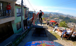
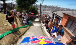
Video: Behind the Scenes at the Urban DH Race in Manizales, Colombia with Remy Metailler
Jan 24, 2020 from pinkbike.com
Tomas Slavik and Remy Metailler talk about the track, their bike settings, and the race lines.
Video: Tomas Slavik's Winning Run from the 2020 Manizales Urban Downhill
Jan 13, 2020 from pinkbike.com
Narrow Streets, big crowds and stair gaps, it can only be the return of the urban downhill season.
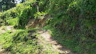
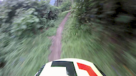
Popular Manizales Mountain Biking Trails
• 100 ★ 0.0 • 4,077 ft • 88 ft • 62 •
Moderate climbing and a fast and technical trail between a pine forest
• 85 ★ 5.0 • 4,705 ft • 26 ft • 50 •
Really fast trail in the middle of the Colombian mountanis, short but really fun and natural, not bike park type
• 5 ★ 0.0 • 4,944 ft • 271 ft • 36 •
Less popular blue difficulty singletrack. This mountain bike primary trail can be used downhill primary. On average it takes 9 minutes to complete this trail.
• 5 ★ 0.0 • 2 miles • 312 ft • 22 •
Fun switchbacks mixed with rock sessions and really fast natural trail.
Manizales Mountain Bike Routes
• 10 miles • 2,526 ft • 0 •
• 19 miles • 3,461 ft • 0 •
• 29 miles • 6,066 ft • 0 •
• 26 miles • 4,623 ft • 0 •
• 29 miles • 8,884 ft • 0 •
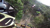
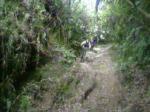
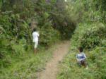
Photos of Manizales Mountain Bike
Recent Trail Reports
| status | trail | date | condition | info | user |
|---|---|---|---|---|---|
| Morenita | Aug 22, 2024 @ 8:43am Aug 22, 2024 | Very Dry | Mykimike | ||
| La Densa | Jan 11, 2024 @ 7:36am Jan 11, 2024 | Dry | allaroundjoe | ||
| Infernal 2 | Mar 8, 2019 @ 6:53am Mar 8, 2019 | Variable | Paredex | ||
| Infernal | Mar 8, 2019 @ 6:48am Mar 8, 2019 | Variable | Paredex |
Activity Feed
| username | action | type | title | date |
|---|---|---|---|---|
| EmmanuelaXNL4z | wishlist | trail | activity #84252069 and 1 more | Nov 16, 2025 @ 9:20am Nov 16, 2025 |
| Michael8rwtxJ | wishlist | trail | activity #77080639 | Jul 31, 2025 @ 4:27am Jul 31, 2025 |
| Flowfinder24 | wishlist | region | activity #65464667 | Jan 31, 2025 @ 8:12am Jan 31, 2025 |
| Mykimike | add | report | activity #57627205 | Aug 22, 2024 @ 8:43am Aug 22, 2024 |
| allaroundjoe | add | report | activity #48159726 and 1 more | Jan 12, 2024 @ 6:02am Jan 12, 2024 |
Activity Type Stats
| activitytype | trails | distance | descent | descent distance | total vertical | rating | global rank | state rank | photos | reports | routes | ridelogs |
|---|---|---|---|---|---|---|---|---|---|---|---|---|
| Mountain Bike | 6 | 6 miles | 6,713 ft | 5 miles | 3,780 ft | 64 | 11 | 1 | 7,272 | |||
| Hike | 6 | 6 miles | 6,713 ft | 5 miles | 3,780 ft | #2,622 | #10 | 11 | 98 | |||
| Trail Running | 6 | 6 miles | 6,713 ft | 5 miles | 3,780 ft | #2,120 | #10 | 11 | 1 |
Frequently Asked Questions About Manizales
▼
What are the highest rated mountain biking trails in Manizales?
The highest rated mountain biking trails in Manizales are:
- Morenita (4.2/5)
- Infernal (4.1/5)
- La Densa (0/5)
- Infernal 2 (0/5)
- Colibri (0/5)
▼
What is the best time of the year to ride in Manizales?
Based on ride log data, the most popular months to ride in Manizales are:
- November (4 activities)
- March (3 activities)
- July (2 activities)
▼
Where can I park to ride in Manizales?
Check the Manizales trail map for trailhead and parking information. Community members regularly update access and parking details for trails in the area.
▼
What is the longest trail in Manizales?
The longest trail in Manizales is Colibri at 1.5 miles. View all trails sorted by distance.
Trails
Points of Interest
- By tato77 & contributors
- Admins: apply
- #9253 - 5,625 views
- manizales activity log | embed map of Manizales mountain bike trails |
Downloading of trail gps tracks in kml & gpx formats is enabled for Manizales.
You must login to download files.