close
-
Layers w
- Weather Layers
- Pro
- Pro
- Pro
- Pro
- Pro
- Pro
- More Layers
- Pro
- Pro
- Pro
- Pro
-
Upgrade to

3D
Trail Conditions
- Unknown
- Snow Groomed
- Snow Packed
- Snow Covered
- Snow Cover Partial
- Freeze/thaw Cycle
- Icy
- Prevalent Mud
- Wet
- Variable
- Ideal
- Dry
- Very Dry
Trail Flow (Ridden Direction)
Trailforks scans users ridelogs to determine the most popular direction each trail is ridden. A good flowing trail network will have most trails flowing in a single direction according to their intension.
The colour categories are based on what percentage of riders are riding a trail in its intended direction.
The colour categories are based on what percentage of riders are riding a trail in its intended direction.
- > 96%
- > 90%
- > 80%
- > 70%
- > 50%
- < 50%
- bi-directional trail
- no data
Trail Last Ridden
Trailforks scans ridelogs to determine the last time a trail was ridden.
- < 2 days
- < 1 week
- < 2 weeks
- < 1 month
- < 6 months
- > 6 months
Trail Ridden Direction
The intended direction a trail should be ridden.
- Downhill Only
- Downhill Primary
- Both Directions
- Uphill Primary
- Uphill Only
- One Direction
Contribute Details
Colors indicate trail is missing specified detail.
- Description
- Photos
- Description & Photos
- Videos
Trail Popularity ?
Trailforks scans ridelogs to determine which trails are ridden the most in the last 9 months.
Trails are compared with nearby trails in the same city region with a possible 25 colour shades.
Think of this as a heatmap, more rides = more kinetic energy = warmer colors.
- most popular
- popular
- less popular
- not popular
ATV/ORV/OHV Filter
Max Vehicle Width
inches
US Cell Coverage
Legend

Radar Time
Activity Recordings
Trailforks uses anonymized public activity data.
?
Activity Recordings
Trailforks uses anonymized public activity data.
?
Personal Heatmap
▶
Activity Types
all
/
none
▶
Options
2
Date range
month
–
Winter Trails
Warning
A routing network for winter maps does not exist. Selecting trails using the winter trails layer has been disabled.
Missing Trails
Most Popular
Least Popular
Trails are colored based on popularity. The more popular a trail is, the more red. Less popular trails trend towards green.
Jump Magnitude Heatmap
Heatmap of where riders jump on trails. Zoom in to see individual jumps, click circles to view jump details.
BC Backroad Status
![map legend]()
Service Road Atlas is a free to use, community-driven service for viewing and creating reports on the numerous back-country service roads around B.C. and Alberta.

Slope Aspect
Direction the slope faces
Trails Deemphasized
Trails are shown in grey.
Only show trails with no bike usage.
Suggested Layers
Based on selected activity type
Save the current map location and zoom level as your default home location whenever this page is loaded.
SaveOne of Australia's most popular and ridden trails, Manly Dam and Bantry Bay are a suburban escape with a wide variety of trail - with plenty of fire/access trails, singletrack, technical descents and challenging climbs. Be sure to check out the views on Trig Track, smash rocks on Gahnia and try and find the flow on 19th Hole.
Join our Manly Dam MTB Trail Crew Volunteer Group to help contribute to maintenance of Manly Dam and surrounding trails.
Remember to be always on the lookout for hikers, dog walkers and local residents - with such close vicinity to suburbia, many trails are multi-use and to be ridden with awareness.
Primary Trail Type: Cross-Country
eBikes Allowed:
Yes
Land Status: City Managed
Land Manager: Northern Beaches Council
 google parking directions
Links
Files
- manlydamtrackandtrailmap.pdf (222 KB)
Activities Click to view
- Mountain Bike
63 trails
- E-Bike
63 trails
- Hike
81 trails
- Trail Running
81 trails
Region Details
- 13
- 3
- 12
- 23
- 8
Region Status
Open as of Jun 20, 2026Local Trail Association
Stats
- Avg Trail Rating
- Trails (view details)
- 86
- Trails Mountain Bike
- 64
- Trails E-Bike
- 63
- Trails Gravel Bike
- 1
- Trails Hike
- 81
- Trails Trail Running
- 81
- Total Distance
- 39 miles
- Total Descent
- 5,529 ft
- Total Vertical
- 511 ft
- Highest Trailhead
- 520 ft
- Reports
- 4,562
- Photos
- 441
- Ridden Counter
- 54,159
Popular Manly Dam Mountain Biking Trails
• 100 ★ 4.3 • 4,701 ft • 2 ft • 2,140 •
Highly rated popular blue difficulty singletrack. This mountain bike primary trail can be used downhill only. Trail visibility is always easy to follow. On average it takes 5 minutes to complete this trail.
• 100 ★ 4.2 • 1,729 ft • 8 ft • 2,073 •
Drop your seat for this super fun and flowy small section, with multiple fun features on a pretty simple section - but watch out for the . New berms added above drop section in 2024. Lines at drop - A line - riders left A/B line -...
• 90 ★ 3.7 • 1 mile • 103 ft • 1,977 •
Tight, windy singletrack full of rock gardens, berms and rock face climbs, which forms the Western side of the Manly Dam loop. Careful, the rock is sandstone, it stays slippery when wet. Trail direction is northbound only.
• 95 ★ 4.4 • 2,024 ft • 27 ft • 1,932 •
Olive Oyl runs northbound alongside the Wakehurst Parkway before popping out onto Firetrail and then leading up to Possums. Singletrack light climb with small technical turns and pinch climbs. While tempting to ride this southbound,...
• 95 ★ 3.5 • 2 miles • 187 ft • 1,587 •
Sandy downhill from Wakehurst Pkwy. Flat and then uphill from the creek. One big climb required
• 100 ★ 4.5 • 1 mile • 150 ft • 1,562 •
Slam your seat up, cut those handlebars down and have a crack at this fun single track full of tight trees, berms and rock rolls. Easy to incorporate into a longer Manly Dam loop, with a few different points along the way to bail out....
• 100 ★ 4.5 • 807 ft • 0 ft • 1,494 •
A fast single track connection from possum to or manly dam. There is a decent gap 2/3 of the way down, B line is left.
• 100 ★ 4.0 • 2,306 ft • 62 ft • 1,476 •
West section of Manly Dam loop, climbing up past Wakehurst Golf and Tennis Clubs. Note exit right to after the car park crossing, new flow trail added in 2024.
Manly Dam Mountain Bike Routes
★ 3.5 • 6 miles • 639 ft • 6 • Loop •
The official, Council Sanctioned Manly Dam route. Signposted and managed by Northern Beaches Council.
★ 3.7 • 7 miles • 430 ft • 14 • Loop •
The common Manly Dam loop, But now with Possums and ! (possums downhill) Common loop ridden by many.
★ 5.0 • 3 miles • 33 ft • 6 • Point to Point •
starting at "downhill to pipe" is the first downhill section with some fun berms and a sick gap. Continue...
★ 4.0 • 3 miles • 164 ft • 5 • Loop •
Starting from French Forest Anglican Church, go south through Bantry Bay Road and hop on all the way down....
★ 1.0 • 7 miles • 471 ft • 8 • Loop •
Extension of the official Manly Dam route to include: - and Possum Trails, when riding up along Wakehurst...
★ 5.0 • 25 miles • 2,147 ft • 11 • Out & Back •
Out and back thru portions of Manly Dam and then on to Cascades and St Ives. Not technical but lots of hills.
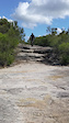
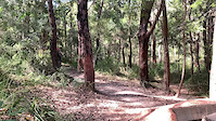
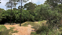
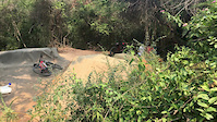
Photos of Manly Dam Mountain Bike
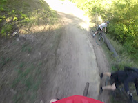
Videos of Manly Dam Mountain Bike
trail: Edward
0:04 |
448 |
Jan 4, 2022

trail: Curl Curl Track
0:08 |
147 |
Jun 30, 2021
trail: Jumping Jack
0:06 |
|
Mar 7, 2021
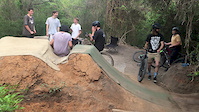
trail: The Grove Pump Track
0:12 |
281 |
Aug 16, 2020

trail: Lockdown
0:24 |
587 |
Apr 17, 2020
trail: The Grove Pump Track
0:05 |
695 |
Mar 2, 2020
trail: The Grove Pump Track
0:21 |
375 |
Mar 1, 2020
trail: The Grove Pump Track
0:12 |
286 |
Mar 1, 2020
Current Trail Warnings
| status | trail | date | condition | user | info |
|---|---|---|---|---|---|
| Yarraman Ave Nature Strip | Jun 1, 2026 @ 11:03pm (America/Los_Angeles) Jun 1, 2026 | Unknown | trailforks Trailforks | ||
| Possum Connector | Jun 1, 2026 @ 11:03pm (America/Los_Angeles) Jun 1, 2026 | Unknown | trailforks Trailforks |
Recent Trail Reports
| status | trail | date | condition | info | user |
|---|---|---|---|---|---|
| Magpies | Jun 21, 2026 @ 3:02pm (Australia/Sydney) Jun 20, 2026 | Ideal | Eddomak | ||
| South Trail | Jun 21, 2026 @ 3:02pm (Australia/Sydney) Jun 20, 2026 | Ideal | Eddomak | ||
| Dropout | Jun 21, 2026 @ 3:02pm (Australia/Sydney) Jun 20, 2026 | Ideal | Eddomak | ||
| 85 Bucks | Jun 21, 2026 @ 3:02pm (Australia/Sydney) Jun 20, 2026 | Ideal | Eddomak | ||
| Bangaroo Bypass | Jun 21, 2026 @ 3:02pm (Australia/Sydney) Jun 20, 2026 | Ideal | Eddomak | ||
| Lower Lockdown | Jun 21, 2026 @ 3:02pm (Australia/Sydney) Jun 20, 2026 | Ideal | Eddomak | ||
| South Trail | Jun 21, 2026 @ 3:02pm (Australia/Sydney) Jun 20, 2026 | Ideal | Eddomak | ||
| East Trail | Jun 21, 2026 @ 3:02pm (Australia/Sydney) Jun 20, 2026 | Ideal | Eddomak | ||
| Cootamundra Side Trail | Jun 21, 2026 @ 3:02pm (Australia/Sydney) Jun 20, 2026 | Ideal | Eddomak | ||
| 19th Hole | Jun 21, 2026 @ 3:02pm (Australia/Sydney) Jun 20, 2026 | Ideal | Eddomak |
Activity Feed
| username | action | type | title | date |
|---|---|---|---|---|
| Eddomak | add | report | activity #97458825 and 15 more | Jun 21, 2026 @ 12:18am Jun 21, 2026 |
| PetrMFypN5 | wishlist | route | activity #97454071 and 3 more | Jun 20, 2026 @ 9:07pm Jun 20, 2026 |
| Robjg7ka9 | wishlist | trail | activity #96863102 | Jun 13, 2026 @ 4:44am Jun 13, 2026 |
| uzr_shready | ridden | trail | activity #96523973 | Jun 7, 2026 @ 11:57pm Jun 7, 2026 |
| nefo | update | trail | activity #96335972 | Jun 5, 2026 @ 6:37pm Jun 5, 2026 |
Recent Comments
| username | type | title | comment | date |
|---|---|---|---|---|
| trail | It will be a dark blue trail when the first... | Jun 3, 2026 @ 11:23pm Jun 3, 2026 | ||
| trail | Trail has received significant repairs and... | Jun 3, 2026 @ 11:21pm Jun 3, 2026 | ||
| trail | Super fun, hit it hard and fast. One technical... | Nov 16, 2025 @ 10:25pm Nov 16, 2025 | ||
| trail | Super fun, lots of rock features, bit of... | Nov 16, 2025 @ 10:23pm Nov 16, 2025 | ||
| trail | I love a bit of a climb as much as the next... | Nov 16, 2025 @ 10:22pm Nov 16, 2025 |
Nearby Areas
| name | distance | ||||
|---|---|---|---|---|---|
| North Curl Curl | 1 | 1 | 2.2 km | ||
| Red Hill Reserve | 7 | 14 | 11 | 1 | 2.8 km |
| Belrose Bowl | 3 | 5 | 5 | 2.8 km | |
| Oxford Falls | 7 | 4 | 4 | 3.6 km | |
| Cascades | 2 | 15 | 12 | 6 | 4.2 km |
Local Badges
-

Completionist32 awarded
Bike & Skill Parks
| name | type | city | rating |
|---|---|---|---|
| The Grove | skill park | Sydney |
Activity Type Stats
| activitytype | trails | distance | descent | descent distance | total vertical | rating | global rank | state rank | photos | reports | routes | ridelogs |
|---|---|---|---|---|---|---|---|---|---|---|---|---|
| Mountain Bike | 63 | 24 miles | 2,710 ft | 10 miles | 512 ft | #89 | #9 | 424 | 4,582 | 14 | 49,457 | |
| E-Bike | 63 | 24 miles | 2,710 ft | 10 miles | 512 ft | #101 | #33 | 19 | 4,520 | 3 | 5,388 | |
| Gravel Bike | 1 | #105 | #13 | 15 | 69 | |||||||
| Hike | 81 | 35 miles | 4,852 ft | 16 miles | 512 ft | #499 | #24 | 2 | 4,392 | 1 | 1,211 | |
| Trail Running | 81 | 35 miles | 4,852 ft | 16 miles | 512 ft | #1,013 | #32 | 4,393 | 1 | 3,291 |
Frequently Asked Questions About Manly Dam
▼
What are the highest rated mountain biking trails in Manly Dam?
The highest rated mountain biking trails in Manly Dam are:
- Possum Trail (4.4/5)
- Popeye (4.4/5)
- Possum Side Trail (4.3/5)
- Jumping Jack (4.3/5)
- The Mistress (4.3/5)
▼
What is the best time of the year to ride in Manly Dam?
Based on ride log data, the most popular months to ride in Manly Dam are:
- August (369 activities)
- September (344 activities)
- July (320 activities)
▼
Where can I park to ride in Manly Dam?
There are 11 parking locations listed in Manly Dam. The most popular parking spots are:
- Wakehurst Parkway Parking
- Manly Vale Public School Parking
- Nyrang Road Car Park
- Manly Dam Parking (Hydro Lab)
- Allambie Heights Parking
▼
What is the longest trail in Manly Dam?
The longest trail in Manly Dam is North Trail at 2.8 km. View all trails sorted by distance.
Activities
Trails
- By brenthillier
 NSMBA TRAILFORKS & contributors
 - Admins: nefo, TrailCare
- #3788 - 59,406 views
- manly dam activity log | embed map of Manly Dam mountain bike trails | manly dam mountain biking points of interest
Downloading of trail gps tracks in kml & gpx formats is enabled for Manly Dam.
You must login to download files.