close
-
Layers w
- Weather Layers
- Pro
- Pro
- Pro
- Pro
- Pro
- Pro
- More Layers
- Pro
- Pro
- Pro
- Pro
-
Upgrade to

3D
Trail Conditions
- Unknown
- Snow Groomed
- Snow Packed
- Snow Covered
- Snow Cover Partial
- Freeze/thaw Cycle
- Icy
- Prevalent Mud
- Wet
- Variable
- Ideal
- Dry
- Very Dry
Trail Flow (Ridden Direction)
Trailforks scans users ridelogs to determine the most popular direction each trail is ridden. A good flowing trail network will have most trails flowing in a single direction according to their intension.
The colour categories are based on what percentage of riders are riding a trail in its intended direction.
The colour categories are based on what percentage of riders are riding a trail in its intended direction.
- > 96%
- > 90%
- > 80%
- > 70%
- > 50%
- < 50%
- bi-directional trail
- no data
Trail Last Ridden
Trailforks scans ridelogs to determine the last time a trail was ridden.
- < 2 days
- < 1 week
- < 2 weeks
- < 1 month
- < 6 months
- > 6 months
Trail Ridden Direction
The intended direction a trail should be ridden.
- Downhill Only
- Downhill Primary
- Both Directions
- Uphill Primary
- Uphill Only
- One Direction
Contribute Details
Colors indicate trail is missing specified detail.
- Description
- Photos
- Description & Photos
- Videos
Trail Popularity ?
Trailforks scans ridelogs to determine which trails are ridden the most in the last 9 months.
Trails are compared with nearby trails in the same city region with a possible 25 colour shades.
Think of this as a heatmap, more rides = more kinetic energy = warmer colors.
- most popular
- popular
- less popular
- not popular
ATV/ORV/OHV Filter
Max Vehicle Width
inches
US Cell Coverage
Legend

Radar Time
Activity Recordings
Trailforks uses anonymized public activity data.
?
Activity Recordings
Trailforks uses anonymized public activity data.
?
Personal Heatmap
▶
Activity Types
all
/
none
▶
Options
2
Date range
month
–
Winter Trails
Warning
A routing network for winter maps does not exist. Selecting trails using the winter trails layer has been disabled.
Missing Trails
Most Popular
Least Popular
Trails are colored based on popularity. The more popular a trail is, the more red. Less popular trails trend towards green.
Jump Magnitude Heatmap
Heatmap of where riders jump on trails. Zoom in to see individual jumps, click circles to view jump details.
BC Backroad Status
![map legend]()
Service Road Atlas is a free to use, community-driven service for viewing and creating reports on the numerous back-country service roads around B.C. and Alberta.

Slope Aspect
Direction the slope faces
Trails Deemphasized
Trails are shown in grey.
Only show trails with no bike usage.
Suggested Layers
Based on selected activity type
Save the current map location and zoom level as your default home location whenever this page is loaded.
Save
No description for Margaret River has been added yet!
Login or register to submit one.
Activities Click to view
- Mountain Bike
121 trails
- E-Bike
65 trails
- Gravel Bike
24 trails
- Adaptive Bike
28 trails
- Winter Fat Bike
6 trails
- Hike
88 trails
- Trail Running
88 trails
- Dirtbike/Moto
6 trails
Region Details
- 31
- 2
- 23
- 57
- 7
Region Status
Open as of Jun 12, 2026Stats
- Avg Trail Rating
- Trails (view details)
- 146
- Trails Mountain Bike
- 121
- Trails E-Bike
- 65
- Trails Gravel Bike
- 24
- Trails Adaptive Bike
- 28
- Trails Winter Fat Bike
- 6
- Trails Hike
- 88
- Trails Trail Running
- 88
- Trails Dirtbike/Moto
- 6
- Total Distance
- 164 miles
- Total Descent
- 13,226 ft
- Total Vertical
- 639 ft
- Highest Trailhead
- 640 ft
- Reports
- 1,315
- Photos
- 181
- Ridden Counter
- 68,097
Sub Regions
-
Boranup Forest
- 5
-
Compartment 10
-
Creek Trails
- 17
- 1
-
Greater Margaret River
- 1
- 6
- 1
-
Return of the Jedi
- 8
-
The Pines
-
Wooditjup Trails
- 1
- 17
- 25
- 6
Popular Margaret River Mountain Biking Trails
• 95 ★ 4.7 • 1,844 ft • 0 ft • 1,633 •
Fun and quite long downhill, linking up to Rock and Root (uphill). Easy Wallride and a couple jumps.
• 95 ★ 4.6 • 2,641 ft • 13 ft • 1,543 •
Highly rated popular blue difficulty singletrack. This mountain bike primary trail can be used one direction and has a moderate overall physical rating with a 13 ft blue climb. It features berm, jump, log ride and rock garden. On average it takes 2 minutes to complete this trail.
• 80 ★ 3.5 • 1,345 ft • 52 ft • 1,451 •
Popular blue difficulty singletrack. This mountain bike primary trail can be used one direction. On average it takes 2 minutes to complete this trail.
• 100 ★ 4.3 • 1,060 ft • 66 ft • 1,431 •
Relatively Easy Up-Hill. Option for 2 log rides, with 'B' Lines to go around. When you get up to the top, make sure that you head to the left and check out the tree with lots of mountain bike parts (chain, brakes, drivetrains, reflectors).
• 100 ★ 4.9 • 1,709 ft • 5 ft • 1,420 •
Jumps Jumps and More Jumps. Doubles, tables, hips, step ups and step downs. Does require a lot of speed and skill to clear most.
• 95 ★ 4.0 • 2,133 ft • 88 ft • 1,412 •
Highly rated popular blue difficulty singletrack. This mountain bike primary trail can be used one direction and has a moderate overall physical rating with a 88 ft blue climb. On average it takes 4 minutes to complete this trail.
• 90 ★ 4.3 • 906 ft • 0 ft • 1,283 •
Cash & Karri represents Margaret Rivers biggest jump line flow trail. It is short and fast, making use of the steeper side of the hill, with many jumps/berms and a token boner log to begin the trail. The emphasis for flow is on the...
Margaret River Mountain Bike Routes
11 miles • 745 ft • 1 • Loop •
From Rotary Park follow the bitumen trail east. It becomes dirt after about 100m. After about 1km the...
17 miles • 1,330 ft • 15 •
Starting at Yahava Koffeewords on the Bussell Hwy, this 28km loop takes in the Wadandi trail and the creek...
★ 2.0 • 9 miles • 382 ft • 2 •
Starting at the Hairy Marron Bike Shop, this 15km loop takes in the trails of South Carters and then takes...
★ 3.0 • 6 miles • 470 ft • 19 • Loop •
A great loop with a relatively easy climb at the start that is rewarded with great natural single track...
6 miles • 742 ft • 32 •
it is a nice route going through all the good downhills in the pines and on some not so bad uphills
Photos of Margaret River Mountain Bike
Videos of Margaret River Mountain Bike
trail: Line Manager
0:10 |
44 |
Jan 29, 2025
trail: Line Manager
0:06 |
9 |
Jan 29, 2025
trail: Big Pine
0:08 |
29 |
Jan 29, 2025

trail: Pugsley
0:43 |
35 |
Dec 21, 2024

trail: Line Manager
0:19 |
27 |
Dec 21, 2024
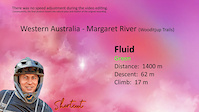
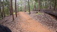
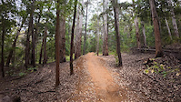
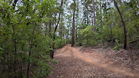
trail: Fluid
4:27 |
44 |
Dec 21, 2024
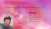
trail: Bluega
0:06 |
39 |
Dec 21, 2024

trail: Black Pearl
0:01 |
50 |
Dec 21, 2024
Recent Trail Reports
| status | trail | date | condition | info | user |
|---|---|---|---|---|---|
| 10 Mile Brook Trail | Jun 13, 2026 @ 8:32am (Australia/Perth) Jun 12, 2026 | Unknown | Yl0Qeg | ||
| Gulliver's Travels | Mar 17, 2026 @ 1:39pm (Australia/Perth) Mar 16, 2026 | Dry | Alfie0042 | ||
| Fluid Climb | Mar 17, 2026 @ 1:39pm (Australia/Perth) Mar 16, 2026 | Ideal | Alfie0042 | ||
| Fluid Shortcut | Mar 17, 2026 @ 1:39pm (Australia/Perth) Mar 16, 2026 | Ideal | Alfie0042 | ||
| Cut Cork link | Mar 16, 2026 @ 3:26pm (Australia/Perth) Mar 16, 2026 | Dry | Alfie0042 | ||
| Pugsley | Mar 16, 2026 @ 3:26pm (Australia/Perth) Mar 16, 2026 | Ideal | Alfie0042 | ||
| High Horse | Mar 16, 2026 @ 3:26pm (Australia/Perth) Mar 16, 2026 | Ideal | Alfie0042 | ||
| Bender | Mar 16, 2026 @ 3:26pm (Australia/Perth) Mar 16, 2026 | Ideal | Alfie0042 | ||
| Thumper | Feb 23, 2026 @ 1:56pm (Australia/Perth) Feb 22, 2026 | Dry | Dsgibson1960 | ||
| Fluid Carpark link | Feb 23, 2026 @ 1:54pm (Australia/Perth) Feb 22, 2026 | Ideal | Dsgibson1960 |
Activity Feed
| username | action | type | title | date |
|---|---|---|---|---|
| sweatytechie | update | trail | activity #97156145 | Jun 16, 2026 @ 7:11pm Jun 16, 2026 |
| sweatytechie | update | region | activity #97155254 | Jun 16, 2026 @ 6:53pm Jun 16, 2026 |
| sweatytechie | update | region | activity #97155202 | Jun 16, 2026 @ 6:52pm Jun 16, 2026 |
| sweatytechie | update | region | activity #97155167 | Jun 16, 2026 @ 6:51pm Jun 16, 2026 |
| sweatytechie | update | region | activity #97155112 | Jun 16, 2026 @ 6:50pm Jun 16, 2026 |
Recent Comments
| username | type | title | comment | date |
|---|---|---|---|---|
| trail | Nice jump line, but can't see what makes this... | Apr 14, 2026 @ 4:12pm Apr 14, 2026 | ||
| trail | This might be slightly controversial. But... | Apr 14, 2026 @ 4:08pm Apr 14, 2026 | ||
| trail | Soooooo good | Jan 22, 2026 @ 4:38am Jan 22, 2026 | ||
| trail | Tree down over trail. Trail blocked. Possible... | Aug 5, 2025 @ 3:54am Aug 5, 2025 | ||
| trail | Berms are not in great shape with lots of... | Mar 13, 2025 @ 6:13am Mar 13, 2025 |
Local Badges
-

Completionist17 awarded -

Epic Ride 50k922 awarded -

Top 10 Trails12 awarded -
Completionist2 awarded -
Completionist0 awarded -

10 Green Trails360 awarded
Activity Type Stats
| activitytype | trails | distance | descent | descent distance | total vertical | rating | global rank | state rank | photos | reports | routes | ridelogs |
|---|---|---|---|---|---|---|---|---|---|---|---|---|
| Mountain Bike | 121 | 95 miles | 7,083 ft | 44 miles | 630 ft | #302 | #18 | 181 | 1,306 | 13 | 21,682 | |
| E-Bike | 65 | 61 miles | 4,278 ft | 29 miles | 630 ft | #1,093 | #68 | 1,192 | 4 | 1,405 | ||
| Gravel Bike | 24 | 26 miles | 1,362 ft | 11 miles | 236 ft | #110 | #84 | 100 | 1 | 39 | ||
| Adaptive Bike | 28 | 49 miles | 1,978 ft | 23 miles | 266 ft | #62 | #120 | 144 | ||||
| Winter Fat Bike | 6 | 2 miles | 226 ft | 3,291 ft | 190 ft | #133 | #76 | 182 | ||||
| Hike | 88 | 138 miles | 9,741 ft | 62 miles | 640 ft | #1,099 | #37 | 1,197 | 685 | |||
| Trail Running | 88 | 138 miles | 9,741 ft | 62 miles | 640 ft | #876 | #35 | 1,197 | 1 | 483 | ||
| Dirtbike/Moto | 6 | 10 miles | 1,299 ft | 6 miles | 630 ft | #362 | #17 | 143 | 30 |
Frequently Asked Questions About Margaret River
▼
What are the best places to ride in Margaret River?
Margaret River has 7 areas to explore for mountain biking. The top rated areas are:
▼
What are the highest rated mountain biking trails in Margaret River?
The highest rated mountain biking trails in Margaret River are:
- Line Manager (4.6/5)
- Pugsley (4.4/5)
- Bluega (4.4/5)
- Pineocchio (4.4/5)
- Big Pine (4.4/5)
▼
What is the best time of the year to ride in Margaret River?
Based on ride log data, the most popular months to ride in Margaret River are:
- October (307 activities)
- January (295 activities)
- December (247 activities)
▼
Where can I park to ride in Margaret River?
There are 27 parking locations listed in Margaret River. The most popular parking spots are: View all parking and trailhead locations on the map to plan your visit.
Activities
Trails
Points of Interest
- By Jake-Hannah
 MPTA & contributors
 - Admins: MTBWA, MRORCA
- #5958 - 33,771 views
- margaret river activity log | embed map of Margaret River mountain bike trails | margaret river mountain biking points of interest
Downloading of trail gps tracks in kml & gpx formats is enabled for Margaret River.
You must login to download files.