close
-
Layers w
- Weather Layers
- Pro
- Pro
- Pro
- Pro
- Pro
- Pro
- More Layers
- Pro
- Pro
- Pro
- Pro
-
Upgrade to

3D
Trail Conditions
- Unknown
- Snow Groomed
- Snow Packed
- Snow Covered
- Snow Cover Partial
- Freeze/thaw Cycle
- Icy
- Prevalent Mud
- Wet
- Variable
- Ideal
- Dry
- Very Dry
Trail Flow (Ridden Direction)
Trailforks scans users ridelogs to determine the most popular direction each trail is ridden. A good flowing trail network will have most trails flowing in a single direction according to their intension.
The colour categories are based on what percentage of riders are riding a trail in its intended direction.
The colour categories are based on what percentage of riders are riding a trail in its intended direction.
- > 96%
- > 90%
- > 80%
- > 70%
- > 50%
- < 50%
- bi-directional trail
- no data
Trail Last Ridden
Trailforks scans ridelogs to determine the last time a trail was ridden.
- < 2 days
- < 1 week
- < 2 weeks
- < 1 month
- < 6 months
- > 6 months
Trail Ridden Direction
The intended direction a trail should be ridden.
- Downhill Only
- Downhill Primary
- Both Directions
- Uphill Primary
- Uphill Only
- One Direction
Contribute Details
Colors indicate trail is missing specified detail.
- Description
- Photos
- Description & Photos
- Videos
Trail Popularity ?
Trailforks scans ridelogs to determine which trails are ridden the most in the last 9 months.
Trails are compared with nearby trails in the same city region with a possible 25 colour shades.
Think of this as a heatmap, more rides = more kinetic energy = warmer colors.
- most popular
- popular
- less popular
- not popular
ATV/ORV/OHV Filter
Max Vehicle Width
inches
US Cell Coverage
Legend

Radar Time
Activity Recordings
Trailforks uses anonymized public activity data.
?
Activity Recordings
Trailforks uses anonymized public activity data.
?
Personal Heatmap
▶
Activity Types
all
/
none
▶
Options
2
Date range
month
–
Winter Trails
Warning
A routing network for winter maps does not exist. Selecting trails using the winter trails layer has been disabled.
Missing Trails
Most Popular
Least Popular
Trails are colored based on popularity. The more popular a trail is, the more red. Less popular trails trend towards green.
Jump Magnitude Heatmap
Heatmap of where riders jump on trails. Zoom in to see individual jumps, click circles to view jump details.
BC Backroad Status
![map legend]()
Service Road Atlas is a free to use, community-driven service for viewing and creating reports on the numerous back-country service roads around B.C. and Alberta.

Slope Aspect
Direction the slope faces
Trails Deemphasized
Trails are shown in grey.
Only show trails with no bike usage.
Suggested Layers
Based on selected activity type
Save the current map location and zoom level as your default home location whenever this page is loaded.
Save
No description for Maroon Mountain has been added yet!
Login or register to submit one.
 google parking directions
Primary Trail Type: All-Mountain & Downhill
google parking directions Activities Click to view
- Mountain Bike
1 trails
- E-Bike
1 trails
- Hike
3 trails
- Trail Running
3 trails
Region Details
- 1
Region Status
Open as of Sep 1, 2025Stats
- Avg Trail Rating
- Trails (view details)
- 1
- Trails Mountain Bike
- 1
- Trails E-Bike
- 1
- Trails Hike
- 3
- Trails Trail Running
- 3
- Total Distance
- 5 miles
- Total Descent Distance
- 3,314 ft
- Total Descent
- 219 ft
- Total Vertical
- 3,416 ft
- Highest Trailhead
- 4,842 ft
- Reports
- 33
- Photos
- 91
- Ridden Counter
- 136
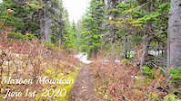
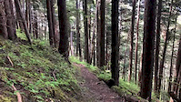
Popular Maroon Mountain Mountain Biking Trails
• 70 ★ 5.0 • 5 miles • 3,503 ft • 85 •
This is an epic out-and-back alpine adventure. Budget half a day to really take in the views and a dip in either of the 2 lakes at the end of the trail. Sections of the trail are very steep so expect to be pushing or carrying your bike...
Photos of Maroon Mountain Mountain Bike
Videos of Maroon Mountain Mountain Bike
trail: Maroon Mountain
0:04 |
95 |
Jun 13, 2020
trail: Maroon Mountain
0:55 |
102 |
May 31, 2020

trail: Maroon Mountain
15:55 |
120 |
Jul 19, 2024 , Terrace
youtuber
![Sometimes the Only Way up Is to Hike......]()

10:26 |
309 |
Sep 16, 2021
trail: Maroon Mountain
718 |
Jul 14, 2020 , Terrace
Recent Trail Reports
| status | trail | date | condition | info | user |
|---|---|---|---|---|---|
| Maroon Mountain | Sep 1, 2025 @ 2:06pm Sep 1, 2025 | Ideal | wilkez TORCA |
Activity Feed
| username | action | type | title | date |
|---|---|---|---|---|
| Gremmen | wishlist | trail | activity #96649814 | Jun 9, 2026 @ 7:56pm Jun 9, 2026 |
| wilkez | add | report | activity #79443702 | Sep 1, 2025 @ 2:06pm Sep 1, 2025 |
| brogankk | add | report | activity #78390925 | Aug 17, 2025 @ 10:11pm Aug 17, 2025 |
| trailbagger | add | photo | activity #76266908 and 3 more | Jul 19, 2025 @ 6:54pm Jul 19, 2025 |
| trailbagger | ridden | trail | activity #76266812 | Jul 19, 2025 @ 6:37pm Jul 19, 2025 |
Recent Comments
| username | type | title | comment | date |
|---|---|---|---|---|
| report | Misty air for the most part, trail slick but... | Aug 26, 2019 @ 8:52am Aug 26, 2019 |
Nearby Areas
| name | distance | ||||
|---|---|---|---|---|---|
| Oliver Creek | 16.4 km | ||||
| Seven Sisters | 1 | 16.5 km | |||
| Terrace Mountain | 7 | 11 | 9 | 1 | 18.4 km |
| Copper Mountain | 2 | 8 | 12 | 4 | 23.5 km |
Activity Type Stats
| activitytype | trails | distance | descent | descent distance | total vertical | rating | global rank | state rank | photos | reports | routes | ridelogs |
|---|---|---|---|---|---|---|---|---|---|---|---|---|
| Mountain Bike | 1 | 5 miles | 220 ft | 3,314 ft | 3,415 ft | #4,396 | #188 | 91 | 33 | 176 | ||
| E-Bike | 1 | 5 miles | 220 ft | 3,314 ft | 3,415 ft | #7,587 | #283 | 29 | 3 | |||
| Hike | 3 | 5 miles | 220 ft | 3,314 ft | 3,415 ft | #13,111 | #463 | 34 | 116 | |||
| Trail Running | 3 | 5 miles | 220 ft | 3,314 ft | 3,415 ft | #12,690 | #448 | 34 | 19 |
- By brenthillier
 NSMBA TRAILFORKS & contributors
 - Admins: TORCA, aleksa, tashpapa, larissacb, NBC, PGBRS, aleksa
- #4615 - 4,894 views
- maroon mountain activity log | embed map of Maroon Mountain mountain bike trails | maroon mountain mountain biking points of interest
Downloading of trail gps tracks in kml & gpx formats is enabled for Maroon Mountain.
You must login to download files.