close
-
Layers w
- Weather Layers
- Pro
- Pro
- Pro
- Pro
- Pro
- Pro
- More Layers
- Pro
- Pro
- Pro
- Pro
-
Upgrade to

3D
Trail Conditions
- Unknown
- Snow Groomed
- Snow Packed
- Snow Covered
- Snow Cover Partial
- Freeze/thaw Cycle
- Icy
- Prevalent Mud
- Wet
- Variable
- Ideal
- Dry
- Very Dry
Trail Flow (Ridden Direction)
Trailforks scans users ridelogs to determine the most popular direction each trail is ridden. A good flowing trail network will have most trails flowing in a single direction according to their intension.
The colour categories are based on what percentage of riders are riding a trail in its intended direction.
The colour categories are based on what percentage of riders are riding a trail in its intended direction.
- > 96%
- > 90%
- > 80%
- > 70%
- > 50%
- < 50%
- bi-directional trail
- no data
Trail Last Ridden
Trailforks scans ridelogs to determine the last time a trail was ridden.
- < 2 days
- < 1 week
- < 2 weeks
- < 1 month
- < 6 months
- > 6 months
Trail Ridden Direction
The intended direction a trail should be ridden.
- Downhill Only
- Downhill Primary
- Both Directions
- Uphill Primary
- Uphill Only
- One Direction
Contribute Details
Colors indicate trail is missing specified detail.
- Description
- Photos
- Description & Photos
- Videos
Trail Popularity ?
Trailforks scans ridelogs to determine which trails are ridden the most in the last 9 months.
Trails are compared with nearby trails in the same city region with a possible 25 colour shades.
Think of this as a heatmap, more rides = more kinetic energy = warmer colors.
- most popular
- popular
- less popular
- not popular
ATV/ORV/OHV Filter
Max Vehicle Width
inches
US Cell Coverage
Legend

Radar Time
Activity Recordings
Trailforks uses anonymized public activity data.
?
Activity Recordings
Trailforks uses anonymized public activity data.
?
Personal Heatmap
▶
Activity Types
all
/
none
▶
Options
2
Date range
month
–
Winter Trails
Warning
A routing network for winter maps does not exist. Selecting trails using the winter trails layer has been disabled.
Missing Trails
Most Popular
Least Popular
Trails are colored based on popularity. The more popular a trail is, the more red. Less popular trails trend towards green.
Jump Magnitude Heatmap
Heatmap of where riders jump on trails. Zoom in to see individual jumps, click circles to view jump details.
BC Backroad Status
![map legend]()
Service Road Atlas is a free to use, community-driven service for viewing and creating reports on the numerous back-country service roads around B.C. and Alberta.

Slope Aspect
Direction the slope faces
Trails Deemphasized
Trails are shown in grey.
Only show trails with no bike usage.
Suggested Layers
Based on selected activity type
Save the current map location and zoom level as your default home location whenever this page is loaded.
Save
No description for Martigues has been added yet!
Login or register to submit one.
This region uses the Uk/Euro style trail grading system.
Activities Click to view
- Mountain Bike
52 trails
- E-Bike
51 trails
- Adaptive Bike
0 trails
- Winter Fat Bike
0 trails
- Hike
45 trails
- Trail Running
44 trails
Region Details
- 21
- 6
- 14
- 10
- 1
Region Status
Caution as of Mar 5, 2026Stats
- Avg Trail Rating
- Trails (view details)
- 52
- Trails Mountain Bike
- 52
- Trails E-Bike
- 51
- Trails Hike
- 45
- Trails Trail Running
- 44
- Total Distance
- 30 miles
- Total Descent Distance
- 16 miles
- Total Descent
- 5,969 ft
- Total Vertical
- 644 ft
- Highest Trailhead
- 656 ft
- Reports
- 44
- Photos
- 6
- Ridden Counter
- 842
Sub Regions
-
Parc de Figuerolles
- 5
- 10
- 9
- 1
Popular Martigues Mountain Biking Trails
• 95 ★ 5.0 • 2,165 ft • 0 ft • 56 •
Popular red difficulty singletrack. This mountain bike primary trail can be used downhill only and has a moderate overall physical rating. Trail visibility is sometimes hard to follow. On average it takes 3 minutes to complete this trail.
• 90 ★ 0.0 • 1,217 ft • 0 ft • 44 •
Popular red difficulty singletrack. This mountain bike primary trail can be used downhill only and has a moderate overall physical rating. Trail visibility is always easy to follow. On average it takes 1 minutes to complete this trail.
• 55 ★ 3.0 • 1,706 ft • 0 ft • 21 •
Moderately popular red difficulty singletrack. This mountain bike primary trail can be used downhill primary and has a moderate overall physical rating. Trail visibility is always easy to follow. On average it takes 9 minutes to complete this trail.
• 85 ★ 4.5 • 3,225 ft • 0 ft • 20 •
Popular red difficulty singletrack. This mountain bike primary trail can be used downhill only and has a moderate overall physical rating. Trail visibility is always easy to follow. On average it takes 3 minutes to complete this trail.
• 65 ★ 5.0 • 1,886 ft • 0 ft • 20 •
Moderately popular red difficulty singletrack. This mountain bike primary trail can be used downhill primary and has a moderate overall physical rating. Trail visibility is always easy to follow. On average it takes 8 minutes to complete this trail.
• 100 ★ 5.0 • 1,982 ft • 0 ft • 17 •
Popular blue difficulty singletrack. This mountain bike primary trail can be used downhill only and has a moderate overall physical rating. Trail visibility is always easy to follow. On average it takes 4 minutes to complete this trail.
• 95 ★ 3.0 • 3,484 ft • 0 ft • 13 •
Popular blue difficulty singletrack. This mountain bike primary trail can be used downhill primary and has a moderate overall physical rating. Trail visibility is always easy to follow. On average it takes 4 minutes to complete this trail.
Martigues Mountain Bike Routes
★ 5.0 • 24 miles • 3,934 ft • 11 • Loop •
Trace 40km de l'édition 2019 de la Randonnée vtt du Rove organisée par le club local. Parcours...
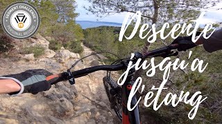
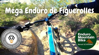
Photos of Martigues Mountain Bike
Videos of Martigues Mountain Bike
trail: Francky's
5:11 |
148 |
Jan 8, 2022 , Martigues
trail: Romaniacs
13:30 |
136 |
Jan 8, 2022 , Martigues

trail: Massane Blue
13:30 |
134 |
Jan 8, 2022 , Martigues

trail: Francky's
16:52 |
107 |
Jan 8, 2022 , Martigues

trail: Le Tube
16:52 |
289 |
Jan 8, 2022 , Martigues

trail: Luna Park
16:52 |
158 |
Jan 8, 2022 , Martigues

trail: Blindspot
16:52 |
153 |
Jan 8, 2022 , Martigues

trail: Frontliner
16:52 |
94 |
Jan 8, 2022 , Martigues
Recent Trail Reports
| status | trail | date | condition | info | user |
|---|---|---|---|---|---|
| DFCI CT 101 | Mar 5, 2026 @ 2:35pm (Europe/Paris) Mar 5, 2026 | Unknown | Kvinbbw8eS | ||
| Luna Park | Sep 25, 2024 @ 3:36pm Sep 25, 2024 | Dry | mrallankey | ||
| Tour d'Observation | Jun 2, 2023 @ 3:25am Jun 2, 2023 | Ideal | EMMANUEL2NVKsN | ||
| GHI | Jun 2, 2023 @ 3:25am Jun 2, 2023 | Unknown | EMMANUEL2NVKsN | ||
| Francky's | May 26, 2023 @ 11:19am May 26, 2023 | Ideal | DavidClaval | ||
| Le Tube | May 26, 2023 @ 11:15am May 26, 2023 | Ideal | DavidClaval | ||
| Romaniacs | May 26, 2023 @ 2:40am May 26, 2023 | Ideal | DavidClaval | ||
| Massane Steep | May 26, 2023 @ 2:40am May 26, 2023 | Prevalent Mud | DavidClaval | ||
| Piste de l'Anse Figuerolles | Feb 26, 2022 @ 6:09am Feb 26, 2022 | Ideal | alekksz | ||
| Micro Connector | Feb 26, 2022 @ 6:09am Feb 26, 2022 | Ideal | alekksz |
Activity Feed
| username | action | type | title | date |
|---|---|---|---|---|
| Kvinbbw8eS | add | report | activity #90003548 | Mar 5, 2026 @ 5:35am Mar 5, 2026 |
| Josxh | wishlist | route | activity #85546679 | Dec 14, 2025 @ 3:12pm Dec 14, 2025 |
| Nepalou | vote | trail | activity #83600510 | Nov 4, 2025 @ 8:17pm Nov 4, 2025 |
| mrallankey | vote | trail | activity #71888943 | May 18, 2025 @ 1:37am May 18, 2025 |
| mrallankey | vote | trail | activity #71834868 and 1 more | May 17, 2025 @ 8:13am May 17, 2025 |
Local Badges
-

10 Blue Trails6 awarded -

10 Black Trails0 awarded -

Epic Ride Climb 2k0 awarded -

Climbing 10k Badge3 awarded -

Climbing 100k Badge0 awarded -

Epic Ride Descent 2k0 awarded
Bike & Skill Parks
| name | type | city | rating |
|---|---|---|---|
| Bikepark Parc de Figuerolles | skill park | Martigues |
Activity Type Stats
| activitytype | trails | distance | descent | descent distance | total vertical | rating | global rank | state rank | photos | reports | routes | ridelogs |
|---|---|---|---|---|---|---|---|---|---|---|---|---|
| Mountain Bike | 52 | 30 miles | 5,971 ft | 16 miles | 643 ft | #5,993 | #246 | 6 | 44 | 2 | 653 | |
| E-Bike | 51 | 30 miles | 5,912 ft | 16 miles | 643 ft | #705 | #57 | 41 | 2 | 158 | ||
| Hike | 45 | 28 miles | 4,692 ft | 14 miles | 446 ft | #5,703 | #190 | 44 | 26 | |||
| Trail Running | 44 | 28 miles | 4,652 ft | 14 miles | 446 ft | #5,157 | #179 | 44 | 18 |
Frequently Asked Questions About Martigues
▼
What are the best places to ride in Martigues?
Martigues has 1 areas to explore for mountain biking. The top rated areas are:
▼
What are the highest rated mountain biking trails in Martigues?
The highest rated mountain biking trails in Martigues are:
- Luna Park (4.3/5)
- Frontliner (4.1/5)
- Massane Blue (4.1/5)
- Kaiju (4.1/5)
- V10 (4.1/5)
▼
What is the best time of the year to ride in Martigues?
Based on ride log data, the most popular months to ride in Martigues are:
- November (14 activities)
- December (11 activities)
- May (9 activities)
▼
Where can I park to ride in Martigues?
There are 11 parking locations listed in Martigues. The most popular parking spots are: View all parking and trailhead locations on the map to plan your visit.
Activities
Trails
Points of Interest
- By hpman83
 TRAILFORKS TFFRANCE & contributors
 - Admins: tomzaniroli, alekksz
- #24659 - 2,144 views
- martigues activity log | embed map of Martigues mountain bike trails | martigues mountain biking points of interest
Downloading of trail gps tracks in kml & gpx formats is enabled for Martigues.
You must login to download files.