close
-
Layers w
- Weather Layers
- Pro
- Pro
- Pro
- Pro
- Pro
- Pro
- More Layers
- Pro
- Pro
- Pro
- Pro
-
Upgrade to

3D
Trail Conditions
- Unknown
- Snow Groomed
- Snow Packed
- Snow Covered
- Snow Cover Partial
- Freeze/thaw Cycle
- Icy
- Prevalent Mud
- Wet
- Variable
- Ideal
- Dry
- Very Dry
Trail Flow (Ridden Direction)
Trailforks scans users ridelogs to determine the most popular direction each trail is ridden. A good flowing trail network will have most trails flowing in a single direction according to their intension.
The colour categories are based on what percentage of riders are riding a trail in its intended direction.
The colour categories are based on what percentage of riders are riding a trail in its intended direction.
- > 96%
- > 90%
- > 80%
- > 70%
- > 50%
- < 50%
- bi-directional trail
- no data
Trail Last Ridden
Trailforks scans ridelogs to determine the last time a trail was ridden.
- < 2 days
- < 1 week
- < 2 weeks
- < 1 month
- < 6 months
- > 6 months
Trail Ridden Direction
The intended direction a trail should be ridden.
- Downhill Only
- Downhill Primary
- Both Directions
- Uphill Primary
- Uphill Only
- One Direction
Contribute Details
Colors indicate trail is missing specified detail.
- Description
- Photos
- Description & Photos
- Videos
Trail Popularity ?
Trailforks scans ridelogs to determine which trails are ridden the most in the last 9 months.
Trails are compared with nearby trails in the same city region with a possible 25 colour shades.
Think of this as a heatmap, more rides = more kinetic energy = warmer colors.
- most popular
- popular
- less popular
- not popular
ATV/ORV/OHV Filter
Max Vehicle Width
inches
US Cell Coverage
Legend

Radar Time
Activity Recordings
Trailforks uses anonymized public activity data.
?
Activity Recordings
Trailforks uses anonymized public activity data.
?
Personal Heatmap
▶
Activity Types
all
/
none
▶
Options
2
Date range
month
–
Winter Trails
Warning
A routing network for winter maps does not exist. Selecting trails using the winter trails layer has been disabled.
Missing Trails
Most Popular
Least Popular
Trails are colored based on popularity. The more popular a trail is, the more red. Less popular trails trend towards green.
Jump Magnitude Heatmap
Heatmap of where riders jump on trails. Zoom in to see individual jumps, click circles to view jump details.
BC Backroad Status
![map legend]()
Service Road Atlas is a free to use, community-driven service for viewing and creating reports on the numerous back-country service roads around B.C. and Alberta.

Slope Aspect
Direction the slope faces
Trails Deemphasized
Trails are shown in grey.
Only show trails with no bike usage.
Suggested Layers
Based on selected activity type
Save the current map location and zoom level as your default home location whenever this page is loaded.
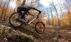
SaveMassachusetts is a mountain bikers paradise There are mountain biking trails in virtually every corner of the state with trails suitable for absolute beginners to some of the gnarliest trails you will find anywhere on the planet. While New England is notorious for its technical riding, we also have some of the smoothest flow trails anywhere.
If you want to find riding opportunities near you there are several ways to go abut it. First of course is to search Trailforks for local riding areas near you. The second alternative is to find your nearest NEMBA chapter. We have added links to all of NEMBA's websites below, where you can find your local chapter as well as contact details. The third option is to look for your nearest bike shop in the Trailforks directory and to chat to them about local riding opportunities.
Also, what sets the mountain biking community in New England apart, is the fact that we have NEMBA with all of its local Chapters. NEMBA believes that mountain bikers care about the trails they ride—that's why we are a chapter-based organization. NEMBA has 29 chapters throughout New England, each offering a wide variety of rides, events and ways to give back to the trails. Join your local NEMBA chapter and become part of our community of mountain bikers!
Region Details
- 3,876
- 504
- 7,022
- 6,115
- 1,359
- 140
- 8
Stats
- Avg Trail Rating
- Trails (view details)
- 21,746
- Trails Mountain Bike
- 19,039
- Trails E-Bike
- 2,766
- Trails Gravel Bike
- 621
- Trails Adaptive Bike
- 883
- Trails Winter Fat Bike
- 4,469
- Trails Horse
- 2,647
- Trails Hike
- 21,059
- Trails Trail Running
- 20,859
- Trails Dirtbike/Moto
- 810
- Trails Observed Trials
- 53
- Trails ATV/ORV/OHV
- 237
- Trails Snowmobile
- 298
- Trails Snowshoe
- 7,995
- Trails Downhill Ski
- 263
- Trails Backcountry Ski
- 514
- Trails Nordic Ski
- 3,733
- Total Distance
- 9,534 miles
- Total Descent
- 854,098 ft
- Total Vertical
- 3,491 ft
- Highest Trailhead
- 3,491 ft
- Reports
- 70,311
- Photos
- 14,034
- Ridden Counter
- 2,169,721
Articles
Video & Race Report: Eastern States Cup DH Finals - Jiminy Peak, MA
Oct 29, 2025 from pinkbike.com
After six months of racing, it's time to crown the 2025 Maxxis ESC Intense Cycles DH series champions.

Video & Race Report: Eastern States Cup Showdown #1 - Jiminy Peak, MA
Jun 24, 2025 from pinkbike.com
This past weekend marked our first Thule Showdown of 2025, and what better place to kick things off than the raw, rugged slopes of Jiminy Peak.

Three Epic Cross-Country Road Trips to Start Planning Now
Feb 26, 2025 from outsideonline.com
From a music-centric journey across the northern U.S. to a national park-studded road trip through the heartland, we’ve got itineraries to get...
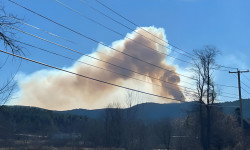
Massachusetts Wildfire Closes Part of Appalachian Trail
Nov 20, 2024 from backpacker.com
More than 80 firefighters and emergency personnel are currently working on the Butternut Fire in Great Barrington, Massachusetts.
Popular Trail Networks
view all areas »Sub Regions
- Berkshire County (397)
- Cape Cod (Barnstable County) (2,524)
- Lower Cape (279)
- Mid Cape (685)
- Outer Cape (142)
- Upper Cape (1,429)
- Essex County (2,544)
- North Shore (2,543)
- Greater Boston (1,336)
- Middlesex County (East) (949)
- Suffolk County (378)
- Martha's Vineyard (296)
- Middlesex County (Northwest) (1,016)
- Merrimack Valley NEMBA (613)
- Nantucket County (142)
- Pioneer Valley (1,517)
- Franklin County (584)
- Hampden County (411)
- Hampshire County (516)
- Southeast Massachusetts (5,797)
- Bristol County (882)
- Norfolk County (2,934)
- Plymouth County (1,922)
- Worcester County (3,499)
- Blackstone Valley (1,990)
- South Central Mass Region (334)
- Wachusett Area (786)
- Ware River Watershed (129)
Popular Massachusetts Mountain Biking Trails
• 95 ★ 0.0 • 4,006 ft • 82 ft • 2,983 •
Popular blue difficulty mixed. This multi-use trail can be used both directions and has a moderate overall physical rating with a 82 ft black diamond climb. Trail visibility is always easy to follow. On average it takes 7 minutes to complete this trail.
• 100 ★ 3.8 • 1,535 ft • 45 ft • 2,547 •
is the old way to get from the area over to the southern part of Vietnam, as well as the land. It is an old school double track with many baby head rocks and calls for good line choice. There is one steep river crossing on the trail
• 100 ★ 3.8 • 1,093 ft • 27 ft • 2,526 •
This easy green trail starts in the Adams Street parking lot and curves all the way up to the intersection with the .
• 75 ★ 4.0 • 4,738 ft • 0 ft • 2,475 •
Great flow trail with big wide flowing berms. May be in between easy and intermediate. some of the berms have some embedded rocks. Nice little air out spots between the turns. With the ride speed a bit of hangtime is possible. It gets a...
• 95 ★ 4.7 • 4,022 ft • 0 ft • 2,443 •
One of the two blue trails to get you to the “Octo” intersection, the largest intersection of trails on the mountain. Nothing that difficult compared to some other blue trails here, but definitely a fun trail to work up some speed on.
• 100 ★ 4.5 • 1 mile • 0 ft • 2,381 •
Easiest jump line at Thunder Mountain, no gaps and everything is rollable. A great trail to build confidence on or to take a break from the more intense riding. Most of this trail is skiable in the winter, IF snow conditions are firm /...
• 100 ★ 3.0 • 561 ft • 10 ft • 2,153 •
A short fun trail that winds up the low ridge and back down to the , right where starts. It is an easy trail with a short off-camber section, a few tight turns as well as a few small rock obstacles that can be jumped. A fun way to ride...
• 95 ★ 3.8 • 2,297 ft • 18 ft • 2,115 •
The is a very technical trail in places on account of the many challenging rock obstacles. But done slowly is very doable for intermediate riders.
Massachusetts Mountain Bike Routes
Vietnam Hall of Fame Featured
★ 3.9 • 8 miles • 628 ft • 32 • Loop •
This route is designed as a good introduction to everything Vietnam has to offer.It passes through the...
Yellow Diamond Route Featured
★ 4.4 • 3 miles • 245 ft • 6 • Point to Point •
This is a challenging intermediate route suitable for solid intermediate and advanced riders. The trails...
Great Blue Hill Loop Featured
★ 5.0 • 22 miles • 1,853 ft • 34 • Loop •
Great tour of the entire Blue Hills system. This includes the white and yellow trails as well as the...
Total Ames Challenge - Featured
★ 4.7 • 11 miles • 574 ft • 61 • Loop •
EXPERT RIDERS ONLY. Technically challenging route with rock rollers, drops, ledges, TTF. No water. No...
WSF Sampler Featured
★ 5.0 • 4 miles • 357 ft • 5 • Loop •
This is a short mountain biking loop that includes some of the fun side trails in the state forest. You...
The Diamond Hunter @ Foxy Featured
★ 4.0 • 8 miles • 724 ft • 37 • Loop •
Tie all the Black Diamond trials in Foxy together with fast flowy singletrack in between. Minimal fire...
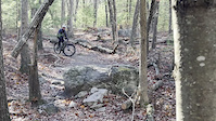
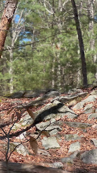
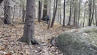
Photos of Massachusetts Mountain Bike
Videos of Massachusetts Mountain Bike

trail: Cliff Claven
0:18 |
2 |
Jun 21, 2026
trail: Cliff Claven
0:13 |
3 |
Jun 21, 2026
trail: Refrigerator Door
0:08 |
15 |
May 11, 2026
trail: Milk-Crate
0:08 |
22 |
May 3, 2026
trail: WSXC
0:04 |
10 |
May 1, 2026
trail: Bald Hill
0:05 |
9 |
Apr 23, 2026
trail: Rocksanne
0:06 |
41 |
Apr 16, 2026
National Scenic Trails & Official Routes
-
Robert Frost Trail
- Mountain Bike
- Hike
- Trail Running
Activity Feed
| username | action | type | title | date |
|---|---|---|---|---|
| spolay | wishlist | route | activity #97950518 | Jun 27, 2026 @ 5:43pm 8 hours |
| patenr | wishlist | region | activity #97948440 | Jun 27, 2026 @ 5:08pm 8 hours |
| Dmfields | wishlist | route | activity #97944783 | Jun 27, 2026 @ 4:12pm 9 hours |
| Jlperras | ridden | trail | activity #97940569 | Jun 27, 2026 @ 3:09pm 10 hours |
| bikesnbooks329 | add | karma | activity #97938420 | Jun 27, 2026 @ 2:39pm 11 hours |
Recent Comments
| username | type | title | comment | date |
|---|---|---|---|---|
| trail | Trail is pretty brush chocked in many spots.... | Jun 27, 2026 @ 9:04am 16 hours | ||
| report | Tree removed | Jun 26, 2026 @ 2:28pm 1 day | ||
| report | Tree removed | Jun 26, 2026 @ 2:28pm 1 day | ||
| report | Cleared! | Jun 26, 2026 @ 9:36am 2 days | ||
| report | big tree fall hard ! | Jun 25, 2026 @ 8:18am 3 days |
Local Badges
-
The VVinter Blackstone '25 - The River & The Gate5 awarded -
The VVinter Blackstone '25 - The Lost Compass5 awarded -

The VVinter Blackstone '25 - The Western Wall71 awarded -
The VVinter Blackstone '25 - The Commons6 awarded -

West Hill Superstar104 awarded -

The VVinter Blackstone '25 - The Horned Deity13 awarded
Bike & Skill Parks
| name | type | city | rating |
|---|---|---|---|
| Thunder Mountain Bike Park | bike park | Charlemont | |
| Jiminy Peak Mountain Resort | bike park | Hancock | |
| Wachusett Mountain Ski Resort | bike park | Princeton | |
| Berkshire East Mountain Ski Resort | bike park | Charlemont | |
| Allston Pumptrack | skill park | Boston |
Upcoming Local Events
Activity Type Stats
| activitytype | trails | distance | descent | descent distance | total vertical | rating | global rank | state rank | photos | reports | routes | ridelogs |
|---|---|---|---|---|---|---|---|---|---|---|---|---|
| Mountain Bike | 19,038 | 8,083 miles | 635,046 ft | 2,938 miles | 3,471 ft | #7 | 12,490 | 69,987 | 904 | 1,202,082 | ||
| E-Bike | 2,766 | 1,434 miles | 136,736 ft | 531 miles | 3,471 ft | #24 | 34 | 50,884 | 86 | 26,137 | ||
| Gravel Bike | 621 | 483 miles | 26,742 ft | 191 miles | 2,352 ft | #22 | 36 | 3,526 | 70 | 7,682 | ||
| Adaptive Bike | 883 | 624 miles | 28,468 ft | 231 miles | 1,824 ft | #17 | 5 | 2,513 | 17 | 50 | ||
| Winter Fat Bike | 4,469 | 2,500 miles | 155,456 ft | 891 miles | 2,339 ft | #5 | 2 | 2,065 | 32 | 571 | ||
| Horse | 2,647 | 1,412 miles | 103,668 ft | 516 miles | 2,789 ft | #14 | 19 | 14,868 | 18 | 1,120 | ||
| Hike | 21,059 | 9,272 miles | 778,107 ft | 3,401 miles | 3,491 ft | #8 | 1,208 | 69,762 | 222 | 82,806 | ||
| Trail Running | 20,859 | 9,218 miles | 772,303 ft | 3,376 miles | 3,491 ft | #9 | 116 | 69,733 | 185 | 75,712 | ||
| Dirtbike/Moto | 810 | 581 miles | 47,789 ft | 229 miles | 2,343 ft | #16 | 14 | 8,000 | 3 | 846 | ||
| Observed Trials | 53 | 42 miles | 4,380 ft | 18 miles | 2,270 ft | #15 | 19 | 165 | 1 | 516 | ||
| ATV/ORV/OHV | 237 | 187 miles | 17,343 ft | 75 miles | 2,349 ft | #21 | 6 | 7,561 | 348 | |||
| Snowmobile | 298 | 216 miles | 17,208 ft | 84 miles | 2,303 ft | #22 | 810 | 2 | 87 | |||
| Snowshoe | 7,995 | 3,670 miles | 272,159 ft | 1,328 miles | 3,491 ft | #3 | 35 | 12,357 | 56 | 2,867 | ||
| Downhill Ski | 263 | 61 miles | 40,843 ft | 54 miles | 2,707 ft | #22 | 2 | 404 | 8,875 | |||
| Backcountry Ski | 514 | 190 miles | 17,067 ft | 71 miles | 3,107 ft | #17 | 31 | 2,341 | 7 | 4,233 | ||
| Nordic Ski | 3,733 | 1,529 miles | 109,820 ft | 545 miles | 2,293 ft | #11 | 8 | 8,203 | 37 | 6,803 |
Activities
- Massachusetts Mountain Biking Trails
- Massachusetts E-Biking Trails
- Massachusetts Gravel Biking Trails
- Massachusetts Adaptive Biking Trails
- Massachusetts Winter Fat Biking Trails
- Massachusetts Horseback Trails
- Massachusetts Hiking Trails
- Massachusetts Trail Running Trails
- Massachusetts Dirtbiking Trails
- Massachusetts Observed Trials Trails
- Massachusetts ATVing/Offroading Trails
- Massachusetts Snowmobiling Trails
- Massachusetts Snowshoeing Trails
- Massachusetts Skiing Trails
- Massachusetts Backcountry Skiing Trails
- Massachusetts Nordic Skiing Trails
Trails
- By canadaka
 Trailforks & contributors
 - Admins: Map Team, IMBA, chuktA, msmcfate, WillieJacobsz, PlumbBobM, ReckitRolley, colinreuter, NEMBAEXEC, BCT
- #3125 - 155,863 views
- massachusetts activity log | embed map of Massachusetts mountain bike trails | massachusetts mountain biking points of interest polygons
Downloading of trail gps tracks in kml & gpx formats is enabled for Massachusetts.
You must login to download files.