close
-
Layers w
- Weather Layers
- Pro
- Pro
- Pro
- Pro
- Pro
- Pro
- More Layers
- Pro
- Pro
- Pro
- Pro
-
Upgrade to

3D
Trail Conditions
- Unknown
- Snow Groomed
- Snow Packed
- Snow Covered
- Snow Cover Partial
- Freeze/thaw Cycle
- Icy
- Prevalent Mud
- Wet
- Variable
- Ideal
- Dry
- Very Dry
Trail Flow (Ridden Direction)
Trailforks scans users ridelogs to determine the most popular direction each trail is ridden. A good flowing trail network will have most trails flowing in a single direction according to their intension.
The colour categories are based on what percentage of riders are riding a trail in its intended direction.
The colour categories are based on what percentage of riders are riding a trail in its intended direction.
- > 96%
- > 90%
- > 80%
- > 70%
- > 50%
- < 50%
- bi-directional trail
- no data
Trail Last Ridden
Trailforks scans ridelogs to determine the last time a trail was ridden.
- < 2 days
- < 1 week
- < 2 weeks
- < 1 month
- < 6 months
- > 6 months
Trail Ridden Direction
The intended direction a trail should be ridden.
- Downhill Only
- Downhill Primary
- Both Directions
- Uphill Primary
- Uphill Only
- One Direction
Contribute Details
Colors indicate trail is missing specified detail.
- Description
- Photos
- Description & Photos
- Videos
Trail Popularity ?
Trailforks scans ridelogs to determine which trails are ridden the most in the last 9 months.
Trails are compared with nearby trails in the same city region with a possible 25 colour shades.
Think of this as a heatmap, more rides = more kinetic energy = warmer colors.
- most popular
- popular
- less popular
- not popular
ATV/ORV/OHV Filter
Max Vehicle Width
inches
US Cell Coverage
Legend

Radar Time
Activity Recordings
Trailforks uses anonymized public activity data.
?
Activity Recordings
Trailforks uses anonymized public activity data.
?
Personal Heatmap
▶
Activity Types
all
/
none
▶
Options
2
Date range
month
–
Winter Trails
Warning
A routing network for winter maps does not exist. Selecting trails using the winter trails layer has been disabled.
Missing Trails
Most Popular
Least Popular
Trails are colored based on popularity. The more popular a trail is, the more red. Less popular trails trend towards green.
Jump Magnitude Heatmap
Heatmap of where riders jump on trails. Zoom in to see individual jumps, click circles to view jump details.
BC Backroad Status
![map legend]()
Service Road Atlas is a free to use, community-driven service for viewing and creating reports on the numerous back-country service roads around B.C. and Alberta.

Slope Aspect
Direction the slope faces
Trails Deemphasized
Trails are shown in grey.
Only show trails with no bike usage.
Suggested Layers
Based on selected activity type
Save the current map location and zoom level as your default home location whenever this page is loaded.
Save
No description for Maui has been added yet!
Login or register to submit one.
Links
Region Supporters & Maintainers
![]()
Eric Hendren
since 2000Maintainer
Region Details
- 3
- 4
- 5
- 11
- 8
Stats
- Avg Trail Rating
- Trails (view details)
- 56
- Trails Mountain Bike
- 35
- Trails E-Bike
- 23
- Trails Horse
- 1
- Trails Hike
- 61
- Trails Trail Running
- 55
- Total Distance
- 114 miles
- Total Descent
- 23,904 ft
- Total Vertical
- 9,896 ft
- Highest Trailhead
- 9,898 ft
- Reports
- 278
- Photos
- 357
- Ridden Counter
- 8,230
Sub Regions
- Makawao Forest Reserve (10)
- Makawao (10)
- Kapalua (8)
- Kula (13)
- Kula Forest Reserve (13)
Popular Maui Mountain Biking Trails
• 70 ★ 4.8 • 2 miles • 0 ft • 562 •
Berms and Jumps. Hard packed clay with thick layer of leaves, sticks and branches. Winter is the wet season and the hard packed clay is slick, AKA Hawaiian ice.
• 100 ★ 3.4 • 994 ft • 39 ft • 561 •
Secret trail starts at top of the lower gravel lot and is a fast fun route to the jump zone, pump track, Tweener trail, main trail intersection. Mostly uphill on the way back to the parking lot. Wetter than the main trail which is...
• 90 ★ 3.0 • 1,215 ft • 130 ft • 524 •
Tweener trail is the preferred downhill route from the loop trail due to the heavy hiker traffic on the main trail. Steeper climbing route than main trail. Viewing of the bottom section of the trail is also possible in few spots.
• 80 ★ 3.0 • 2 miles • 959 ft • 301 •
Kahakapao West Loop Trail. This is the easier way to the top and connects with the Kahakapao East Loop Trail, /Downhill Flow Trail and the Renegade Trail. The West Loop Trail climbs just over 2 miles and includes single track and plenty...
• 45 ★ 4.5 • 2 miles • 784 ft • 257 •
. This trail has the added level of difficulty of roots, tight switchback corners and an average of just over a seven-percent grade. It’s just a bit shorter than the West Loop Trail but more technical. Also one of Makawao Forest...
• 95 ★ 4.4 • 1 mile • 0 ft • 249 •
The upper end is access via the Waipoli doubletrack to . It beings in low shrubs and grass slopes with lots of whoops and turns. The fun factor is high with plenty of opportunities to catch air. The middle section of the trail...
• 35 ★ 3.0 • 1 mile • 79 ft • 148 •
The is a two-way traffic trail and is as challenging to climb as it is to descend. There’s a lot of exposed off-camber roots, narrow trail sections, and hair-pin turns. One section borders the gulch and is extra challenging. Renegade...
Maui Mountain Bike Routes
17 miles • 137 ft • 1 • Point to Point •
Drive up at 3am to see the sunrise - it's a long drive. You have to reserve a slot to access this National...
10 miles • 1,975 ft • 6 • Loop •
Makawao Forest reserve that hits , , and
• 7 miles • 1,065 ft • 5 •
• 13 miles • 3,230 ft • 3 •
• 9 miles • 1,951 ft • 5 •
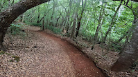
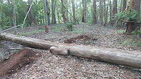
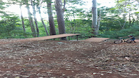
Photos of Maui Mountain Bike
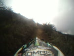
Videos of Maui Mountain Bike
trail: Pineapple Express
0:16 |
|
May 31, 2022

trail: Pineapple Express
0:10 |
183 |
May 8, 2022
trail: Renegade Trail
0:05 |
201 |
Nov 3, 2021
trail: Pineapple Express
0:08 |
214 |
Nov 28, 2020
trail: Mamane
4:29 |
586 |
Nov 26, 2010

trail: Skyline
4:18 |
1006 |
Nov 26, 2010
trail: Skyline
7:37 |
1178 |
Nov 26, 2010

28:27 |
337 |
Sep 9, 2022
Recent Trail Reports
| status | trail | date | condition | info | user |
|---|---|---|---|---|---|
| South Maui Greenway Maui | Mar 16, 2026 @ 2:08pm (Pacific/Honolulu) Mar 16, 2026 | Prevalent Mud | whiskytangofox | ||
| Pineapple Express Kahakapao Recreation Area | Mar 26, 2025 @ 6:53pm Mar 26, 2025 | Ideal | PhilipZMTuxR | ||
| Kahakapao East Loop Trail Kahakapao Recreation Area | Mar 26, 2025 @ 6:51pm Mar 26, 2025 | Ideal | PhilipZMTuxR | ||
| Fong Ridge Road Kahakapao Recreation Area | Jan 19, 2025 @ 8:17am Jan 19, 2025 | Variable | JamesAgepoguyiu | ||
| Upper Waiohuli Kula Forest Reserve | Jan 18, 2025 @ 12:06pm Jan 18, 2025 | Ideal | JamesAgepoguyiu | ||
| Upper Waiohuli to gate Kula Forest Reserve | Jan 18, 2025 @ 12:06pm Jan 18, 2025 | Ideal | JamesAgepoguyiu | ||
| Waiakoa Loop Kula Forest Reserve | Dec 16, 2024 @ 2:30pm Dec 16, 2024 | Ideal | WillieJacobsz Trailforks | ||
| Boundary Kula Forest Reserve | Nov 3, 2024 @ 1:34am Nov 3, 2024 | Dry | ooolongT | ||
| Renegade Trail Kahakapao Recreation Area | Sep 3, 2024 @ 7:34pm Sep 3, 2024 | Dry | docjas13 | ||
| Waiakoa Access Road Kula Forest Reserve | Jun 23, 2024 @ 6:32pm Jun 23, 2024 | Dry | ChipC |
Activity Feed
| username | action | type | title | date |
|---|---|---|---|---|
| skibikeJunkie | wishlist | trail | activity #96636771 | Jun 9, 2026 @ 4:24pm Jun 9, 2026 |
| WDNcNH | wishlist | route | activity #96526284 | Jun 8, 2026 @ 1:30am Jun 8, 2026 |
| bfruge | wishlist | route | activity #96336648 | Jun 5, 2026 @ 6:53pm Jun 5, 2026 |
| YekaiLuke | ridden | trail | activity #95534858 and 5 more | May 25, 2026 @ 5:27pm May 25, 2026 |
| P6MJ65iy | add | photo | activity #94769264 and 2 more | May 15, 2026 @ 2:29pm May 15, 2026 |
Recent Comments
| username | type | title | comment | date |
|---|---|---|---|---|
| trail | Recommend renting an emtn bike from Krank and... | Oct 14, 2025 @ 5:28pm Oct 14, 2025 | ||
| trail | More of an access road but the views are... | Sep 2, 2025 @ 11:52pm Sep 2, 2025 | ||
| trail | Fun, easy trails. Some lips let you catch some... | Sep 2, 2025 @ 11:45pm Sep 2, 2025 | ||
| trail | Real well made trail with some cracking... | Jul 8, 2024 @ 7:49pm Jul 8, 2024 | ||
| trail | Pedally but pretty good fun. Nice berms and... | Jul 8, 2024 @ 7:46pm Jul 8, 2024 |
Local Badges
-

Epic Mountain Bike Climb 2k1 awarded -

Climbing 10k Badge0 awarded -

Mountain Biking 100k Badge0 awarded -

Epic Ride Descent 2k1 awarded -

Descent 10k Badge0 awarded -

Descent 100k Badge0 awarded
Bike & Skill Parks
| name | type | city | rating |
|---|---|---|---|
| Akamai Skills Area | skill park | Makawao | |
| ‘Akahi Akahi Skills Area | skill park | Makawao | |
| Akamai Skills Area | skill park | Makawao | |
| Pauma Skills Area | skill park | Makawao | |
| Pauma Skills Area | skill park | Makawao |
Local Mountain Biking Directory
-
Maui Mountain Bike Coalition
![Maui Mountain Bike Coalition]()
-
Mountain Bike Maui
![Mountain Bike Maui]()
-
Na Ala Hele
![Na Ala Hele]()
-
Krank CyclesBike Shop
![Krank Cycles]()
-
West Maui CyclesBike Shop
![West Maui Cycles]()
-
Boss Frogs CyclesBike Shop
Activity Type Stats
| activitytype | trails | distance | descent | descent distance | total vertical | rating | global rank | state rank | photos | reports | routes | ridelogs |
|---|---|---|---|---|---|---|---|---|---|---|---|---|
| Mountain Bike | 35 | 46 miles | 11,496 ft | 24 miles | 9,895 ft | 270 | 270 | 3 | 13,929 | |||
| E-Bike | 23 | 11 miles | 102 ft | 4 miles | 112 ft | 180 | 1,557 | |||||
| Horse | 1 | 1 mile | 702 ft | 108 | 15 | |||||||
| Hike | 61 | 111 miles | 22,526 ft | 53 miles | 9,895 ft | 83 | 243 | 7,146 | ||||
| Trail Running | 55 | 96 miles | 21,289 ft | 47 miles | 9,895 ft | 9 | 239 | 568 |
Activities
Trails
Points of Interest
- Kipahulu Visitors Center Information
- [cave] Piilani Trail Cave Other
- Wai’ānapanapa State Park Campground Camping
- Makahiku Overlook Viewpoint
- Upper Falls Sight
- Haleakalā Visitor Center Information
- Polipoli Springs State Recreation Area Camping Site
- Hosmer Grove Camping
- Birds on the Edge Viewpoint
- Seven Sacred Pools of 'Ohe'o Sight
- Magnetic Peak (3,051 m)
- Kolekole (3,050 m)
- Kalepeamoa (2,768 m)
- By brenthillier
 NSMBA TRAILFORKS & contributors
 - Admins: MMBC
- #4634 - 24,236 views
- maui activity log | embed map of Maui mountain bike trails | maui mountain biking points of interest
Downloading of trail gps tracks in kml & gpx formats is enabled for Maui.
You must login to download files.