close
-
Layers w
- Weather Layers
- Pro
- Pro
- Pro
- Pro
- Pro
- Pro
- More Layers
- Pro
- Pro
- Pro
- Pro
-
Upgrade to

3D
Trail Conditions
- Unknown
- Snow Groomed
- Snow Packed
- Snow Covered
- Snow Cover Partial
- Freeze/thaw Cycle
- Icy
- Prevalent Mud
- Wet
- Variable
- Ideal
- Dry
- Very Dry
Trail Flow (Ridden Direction)
Trailforks scans users ridelogs to determine the most popular direction each trail is ridden. A good flowing trail network will have most trails flowing in a single direction according to their intension.
The colour categories are based on what percentage of riders are riding a trail in its intended direction.
The colour categories are based on what percentage of riders are riding a trail in its intended direction.
- > 96%
- > 90%
- > 80%
- > 70%
- > 50%
- < 50%
- bi-directional trail
- no data
Trail Last Ridden
Trailforks scans ridelogs to determine the last time a trail was ridden.
- < 2 days
- < 1 week
- < 2 weeks
- < 1 month
- < 6 months
- > 6 months
Trail Ridden Direction
The intended direction a trail should be ridden.
- Downhill Only
- Downhill Primary
- Both Directions
- Uphill Primary
- Uphill Only
- One Direction
Contribute Details
Colors indicate trail is missing specified detail.
- Description
- Photos
- Description & Photos
- Videos
Trail Popularity ?
Trailforks scans ridelogs to determine which trails are ridden the most in the last 9 months.
Trails are compared with nearby trails in the same city region with a possible 25 colour shades.
Think of this as a heatmap, more rides = more kinetic energy = warmer colors.
- most popular
- popular
- less popular
- not popular
ATV/ORV/OHV Filter
Max Vehicle Width
inches
US Cell Coverage
Legend

Radar Time
Activity Recordings
Trailforks uses anonymized public activity data.
?
Activity Recordings
Trailforks uses anonymized public activity data.
?
Personal Heatmap
▶
Activity Types
all
/
none
▶
Options
2
Date range
month
–
Winter Trails
Warning
A routing network for winter maps does not exist. Selecting trails using the winter trails layer has been disabled.
Missing Trails
Most Popular
Least Popular
Trails are colored based on popularity. The more popular a trail is, the more red. Less popular trails trend towards green.
Jump Magnitude Heatmap
Heatmap of where riders jump on trails. Zoom in to see individual jumps, click circles to view jump details.
BC Backroad Status
![map legend]()
Service Road Atlas is a free to use, community-driven service for viewing and creating reports on the numerous back-country service roads around B.C. and Alberta.

Slope Aspect
Direction the slope faces
Trails Deemphasized
Trails are shown in grey.
Only show trails with no bike usage.
Suggested Layers
Based on selected activity type
Save the current map location and zoom level as your default home location whenever this page is loaded.
Save
No description for Mauricie has been added yet!
Login or register to submit one.
Region Details
- 9
- 3
- 49
- 74
- 45
- 18
- 6
Local Trail Association
Stats
- Avg Trail Rating
- Trails (view details)
- 285
- Trails Mountain Bike
- 204
- Trails E-Bike
- 72
- Trails Horse
- 8
- Trails Hike
- 144
- Trails Trail Running
- 144
- Trails Snowmobile
- 1
- Trails Snowshoe
- 28
- Trails Backcountry Ski
- 3
- Trails Nordic Ski
- 36
- Total Distance
- 461 miles
- Total Descent
- 48,269 ft
- Total Vertical
- 1,542 ft
- Highest Trailhead
- 1,575 ft
- Reports
- 1,200
- Photos
- 271
- Ridden Counter
- 45,280
Sub Regions
- La Tuque (43)
- Mauricycle (41)
- Saint-Mathieu-Du-Parc (70)
- Mont SM (47)
- Parc Récréoforestier St-Mathieu (23)
- Saint-Paulin (7)
- Le Baluchon (7)
- Saint-Stanislas-de-Champlain (17)
- Shawinigan (42)
- Trois-Rivières (37)
- Parc national de la Mauricie (2)
- Parc Récréotouristique Héritage Carcajou (0)
Popular Mauricie Mountain Biking Trails
• 95 ★ 4.8 • 1,916 ft • 0 ft • 1,055 •
Trail à rouler brake less!!! La pente est parfaite pour se laisser aller sans trop réfléchir. Elle est la meilleur option pour se rendre rapidement à (monter sommet 3) et à La Tricoline (partie 2).
• 90 ★ 4.7 • 2,785 ft • 11 ft • 1,016 •
La Tricoline, tricote du sommet 3 trois jusqu'à la base de la montagne. Cette trail est la plus longue et smooth descente du MSM. Du gros fun pour tous les niveaux de rider. Elle est le meilleur choix de descente pour les riders débutants
• 100 ★ 4.2 • 1,995 ft • 33 ft • 1,001 •
Section intermédiaire de la monter vers le sommet 3. Permet au rider de rester sur un sentier bleu en sortant de .
• 85 ★ 4.7 • 3,645 ft • 3 ft • 917 •
est la descente la plus populaire de la montagne. ENDURO :Si vous suivez les indications pour le short-cut, une drop d'environ 6 pieds vous y attend. (Allez voir avant de dropper, il faut tourner légèrement à droite)
• 90 ★ 5.0 • 509 ft • 0 ft • 877 •
Cette trail offre une option supplémentaire lorsque l'on ride la . La descente commence en escalier dans le lit d'un ruisseau, elle se poursuit dans un bench cut étroit et exposé. À ne pas manqué, elle vaut le détour.
Mauricie Mountain Bike Routes
10 miles • 779 ft • 1 •
Excellente piste pour intermédiaire, pas trop technique, se roule bien avec quelques petits obstacles, à...
13 miles • 1,919 ft • 7 • Loop •
Monté par la Descente, c'est don bien bizarre. La Malade Mental porte bien son nom. Elle va vous amener...
8 miles • 910 ft • 3 • Loop •
Circuit facile. Beaucoup de monter pour les gens habitué au Downhill ou des trails plus plat.
Videos of Mauricie Mountain Bike
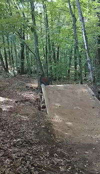
trail: Les Sauts
0:08 |
71 |
Aug 20, 2025
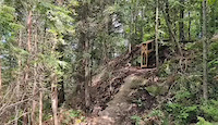
trail: La Double D
0:06 |
32 |
Oct 29, 2024
trail: La Double D
0:07 |
55 |
Oct 29, 2024

trail: Les Sauts
0:07 |
34 |
Oct 29, 2024
trail: Riviere Milette
6:39 |
51 |
Jun 25, 2023
trail: Riviere Milette
2:20 |
15 |
Jun 25, 2023
trail: Riviere Milette
0:49 |
36 |
Jun 25, 2023
0:13 |
71 |
Sep 13, 2022
Recent Trail Reports
Activity Feed
| username | action | type | title | date |
|---|---|---|---|---|
| ericmtb77 | add | trail | activity #96579407 | Jun 8, 2026 @ 6:55pm Jun 8, 2026 |
| mikulic | vote | trail | activity #96268423 | Jun 4, 2026 @ 6:35pm Jun 4, 2026 |
| trailforks | add | report | activity #95880790 | May 30, 2026 @ 1:03pm May 30, 2026 |
| flirette22 | wishlist | region | activity #95785398 | May 29, 2026 @ 9:59am May 29, 2026 |
| trailforks | add | video | activity #95499141 | May 25, 2026 @ 10:00am May 25, 2026 |
Recent Comments
| username | type | title | comment | date |
|---|---|---|---|---|
| trail | This is a newer (2024) trail. Not very... | Oct 16, 2025 @ 2:43pm Oct 16, 2025 | ||
| trail | Fun little section with some technical areas | Oct 15, 2025 @ 11:49am Oct 15, 2025 | ||
| trail | A little Flo section | Oct 15, 2025 @ 11:45am Oct 15, 2025 | ||
| trail | A cross country style trail, but with some... | Oct 15, 2025 @ 11:41am Oct 15, 2025 | ||
| trail | This one was a lot of fun | Oct 15, 2025 @ 10:56am Oct 15, 2025 |
Local Badges
-

10 Blue Trails569 awarded -

Top 10 Trails0 awarded -
Top 10 Trails135 awarded -

Completionist0 awarded -

Epic Ride 50k52 awarded -
Top 10 Trails4 awarded
Bike & Skill Parks
| name | type | city | rating |
|---|---|---|---|
| BMX Pointe-du-Lac | skill park | Trois-Rivières | |
| BMX La Tuque | skill park | La Tuque | |
| BMX Cap-de-la-Madeleine | skill park | Trois-Rivières | |
| Dirt Jump Énergie CMB | skill park | Trois-Rivières | |
| Pumptrack Énergie CMB | skill park | Trois-Rivières |
Activity Type Stats
| activitytype | trails | distance | descent | descent distance | total vertical | rating | global rank | state rank | photos | reports | routes | ridelogs |
|---|---|---|---|---|---|---|---|---|---|---|---|---|
| Mountain Bike | 204 | 184 miles | 23,091 ft | 68 miles | 1,115 ft | 267 | 1,163 | 10 | 30,277 | |||
| E-Bike | 72 | 60 miles | 9,173 ft | 27 miles | 1,070 ft | 1,043 | 6 | 1,404 | ||||
| Horse | 8 | 18 miles | 1,201 ft | 6 miles | 564 ft | 339 | 4 | |||||
| Hike | 144 | 249 miles | 26,952 ft | 91 miles | 1,539 ft | 2 | 1,094 | 1,601 | ||||
| Trail Running | 144 | 249 miles | 26,952 ft | 91 miles | 1,539 ft | 1,094 | 740 | |||||
| Snowmobile | 1 | 66 miles | 3,520 ft | 24 miles | 850 ft | 1 | 11 | |||||
| Snowshoe | 28 | 87 miles | 10,781 ft | 38 miles | 1,463 ft | 20 | 1 | 285 | ||||
| Backcountry Ski | 3 | 5 miles | 308 ft | 2 miles | 190 ft | 6 | 370 | |||||
| Nordic Ski | 36 | 90 miles | 5,377 ft | 32 miles | 1,083 ft | 20 | 1,578 |
Activities
Trails
- By brenthillier
 NSMBA TRAILFORKS & contributors
 - Admins: VQ, bigjay, StephaneMarceau, Canadmos
- #7332 - 8,563 views
- mauricie activity log | embed map of Mauricie mountain bike trails | mauricie mountain biking points of interest
Downloading of trail gps tracks in kml & gpx formats is enabled for Mauricie.
You must login to download files.