close
-
Layers w
- Weather Layers
- Pro
- Pro
- Pro
- Pro
- Pro
- Pro
- More Layers
- Pro
- Pro
- Pro
- Pro
-
Upgrade to

3D
Trail Conditions
- Unknown
- Snow Groomed
- Snow Packed
- Snow Covered
- Snow Cover Partial
- Freeze/thaw Cycle
- Icy
- Prevalent Mud
- Wet
- Variable
- Ideal
- Dry
- Very Dry
Trail Flow (Ridden Direction)
Trailforks scans users ridelogs to determine the most popular direction each trail is ridden. A good flowing trail network will have most trails flowing in a single direction according to their intension.
The colour categories are based on what percentage of riders are riding a trail in its intended direction.
The colour categories are based on what percentage of riders are riding a trail in its intended direction.
- > 96%
- > 90%
- > 80%
- > 70%
- > 50%
- < 50%
- bi-directional trail
- no data
Trail Last Ridden
Trailforks scans ridelogs to determine the last time a trail was ridden.
- < 2 days
- < 1 week
- < 2 weeks
- < 1 month
- < 6 months
- > 6 months
Trail Ridden Direction
The intended direction a trail should be ridden.
- Downhill Only
- Downhill Primary
- Both Directions
- Uphill Primary
- Uphill Only
- One Direction
Contribute Details
Colors indicate trail is missing specified detail.
- Description
- Photos
- Description & Photos
- Videos
Trail Popularity ?
Trailforks scans ridelogs to determine which trails are ridden the most in the last 9 months.
Trails are compared with nearby trails in the same city region with a possible 25 colour shades.
Think of this as a heatmap, more rides = more kinetic energy = warmer colors.
- most popular
- popular
- less popular
- not popular
ATV/ORV/OHV Filter
Max Vehicle Width
inches
US Cell Coverage
Legend

Radar Time
Activity Recordings
Trailforks uses anonymized public activity data.
?
Activity Recordings
Trailforks uses anonymized public activity data.
?
Personal Heatmap
▶
Activity Types
all
/
none
▶
Options
2
Date range
month
–
Winter Trails
Warning
A routing network for winter maps does not exist. Selecting trails using the winter trails layer has been disabled.
Missing Trails
Most Popular
Least Popular
Trails are colored based on popularity. The more popular a trail is, the more red. Less popular trails trend towards green.
Jump Magnitude Heatmap
Heatmap of where riders jump on trails. Zoom in to see individual jumps, click circles to view jump details.
BC Backroad Status
![map legend]()
Service Road Atlas is a free to use, community-driven service for viewing and creating reports on the numerous back-country service roads around B.C. and Alberta.

Slope Aspect
Direction the slope faces
Trails Deemphasized
Trails are shown in grey.
Only show trails with no bike usage.
Suggested Layers
Based on selected activity type
Save the current map location and zoom level as your default home location whenever this page is loaded.
Save
No description for Maydena has been added yet!
Login or register to submit one.
Region Supporters & Maintainers
trail builderSponsor
Activities Click to view
- Mountain Bike
163 trails
- E-Bike
152 trails
- Gravel Bike
0 trails
- Adaptive Bike
0 trails
- Horse
40 trails
- Hike
160 trails
- Trail Running
154 trails
- Dirtbike/Moto
38 trails
- Observed Trials
6 trails
- ATV/ORV/OHV
41 trails
- Snowshoe
4 trails
- Backcountry Ski
5 trails
Region Details
- 29
- 31
- 53
- 29
- 15
Region Status
Caution as of Apr 14, 2026Stats
- Avg Trail Rating
- Trails (view details)
- 241
- Trails Mountain Bike
- 164
- Trails E-Bike
- 152
- Trails Horse
- 40
- Trails Hike
- 160
- Trails Trail Running
- 154
- Trails Dirtbike/Moto
- 38
- Trails Observed Trials
- 6
- Trails ATV/ORV/OHV
- 41
- Trails Snowmobile
- 1
- Trails Snowshoe
- 4
- Trails Backcountry Ski
- 5
- Trails Nordic Ski
- 3
- Total Distance
- 602 miles
- Total Descent Distance
- 263 miles
- Total Descent
- 89,629 ft
- Total Vertical
- 4,561 ft
- Highest Trailhead
- 4,571 ft
- Reports
- 1,353
- Photos
- 2,278
- Ridden Counter
- 81,865
Articles
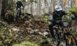
Photo Epic: Practice - Red Bull Hardline Tasmania 2026
Feb 5, 2026 from pinkbike.com
A rapidly evolving course is keeping things interesting down south.

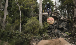
Video: The Wild First Hits of Red Bull Hardline Tasmania 2026
Feb 4, 2026 from pinkbike.com
Day one had no shortage of rowdy moments as riders got up to speed on the track.
Video: Redbull Hardline Tasmania First Looks With Mille Johnset
Feb 3, 2026 from pinkbike.com
Mille Johnset takes us along for the pre-race action, kit reveals, and the first "real-person" look at the massive features.
Red Bull Confirms Details for Third Annual Hardline Tasmania in 2026
Sep 16, 2025 from pinkbike.com
Hardline returns to Maydena with new course sections and full spectator access.
Sub Regions
-
Hartz Mountains National Park
-
Maydena Bike Park
- 23
- 38
- 26
- 16
- 5
-
Southwest National Park
- 1
- 1
- 1
Popular Maydena Mountain Biking Trails
• 100 ★ 4.2 • 974 ft • 0 ft • 1,937 •
Your lap is nearly over, but it’s ! Advanced riders can finish their lap with a number of larger table top jumps leading right to our base hub.
• 85 ★ 4.2 • 2,037 ft • 36 ft • 1,724 •
Dont't let the green circle fool you. Scandanavia is one of the most fun flow trails on our hill. It is ideal for beginners progressing from , or for the more advanced rider looking to cut some shapes on more steep corners and...
• 100 ★ 3.1 • 1,283 ft • 9 ft • 1,671 •
got a renovation in 2022 turning into a blue jump trail. Table top jumps and fast, free-flowing berms make this one of the most fun trails in the park .This trail is a great blue jump option to finish your lap of the park.
• 95 ★ 4.4 • 3,619 ft • 0 ft • 1,660 •
weaves through its namesake Plant the world’s tallest heath plant, offering another flow/technical blend. The trail features dolerite soils, which make for a technical ride through some sections. Another trail with plenty of side hits...
• 90 ★ 4.3 • 1,181 ft • 14 ft • 1,576 •
An MBP classic, features seemingly endless berms and rollers. Beginning at our Lower Mountain Trailhead, riders can continue on down a black diamond lower section called , or transfer over to neighbouring green trail .
• 95 ★ 4.5 • 1,014 ft • 3 ft • 1,443 •
For riders with advanced jump skills, offers a number of large hip jumps and high-speed berms. While the jumps are rollable, this trail is only suitable for advanced riders.
• 25 ★ 4.0 • 3,770 ft • 7 ft • 1,430 •
It all starts with ! Weaving through the snow gums, is a flow/technical blend trail, which acts as a perfect warm up for the park. Keep an eye out for side hits and locals lines, or just work your way through the berms.
• 90 ★ 4.2 • 1,565 ft • 3 ft • 1,400 •
is well known for its big flowing berms, multiple line choices and jumps that vary from small to large with lips that change depending on your line choice.
Maydena Mountain Bike Routes
★ 5.0 • 30 miles • 7,517 ft • 35 •
a fun weekend of riding. nothing to technical. all fun and flowy.
4 miles • 748 ft • 11 •
the tas gravity endro at maydena bike park the challenge event.
4 miles • 114 ft • 14 •
Im just wanting to copy parts of this for my other routes lol
34 miles • 9,473 ft • 43 • Loop •
In March 2023, the inaugural UCI Enduro World Cup and Enduro of Maydena will take place in Tasmania...
★ 5.0 • 68 miles • 4,848 ft • 0 • Point to Point •
The Southwest National Park is a 6,182.67-square-kilometre (2,387.14 sq mi) national park located in the...
★ 2.0 • 33 miles • 4,416 ft • 1 • Out & Back •
Goes to stunning Tim Shea Mtn and then visited the cave “Growling Swallet” where the Junne River...
Photos of Maydena Mountain Bike
Videos of Maydena Mountain Bike
trail: Express Lane
0:06 |
108 |
Jan 29, 2025

trail: Maydena Hits
0:09 |
8634 |
Mar 7, 2024
trail: Seager Lookout Trail
0:31 |
9 |
Feb 7, 2023
trail: Super Funk
0:15 |
36 |
Jan 29, 2023
trail: Maydena Hits
0:00 |
64 |
Feb 18, 2022

trail: Thrash Horse
0:58 |
84 |
Jan 30, 2022
trail: Midline
0:05 |
|
Apr 29, 2021
trail: Yeah Gnar
0:43 |
899 |
Mar 4, 2020
Recent Trail Reports
| status | trail | date | condition | info | user |
|---|---|---|---|---|---|
| Flight School | Apr 2, 2026 @ 4:36pm (Australia/Hobart) Apr 1, 2026 | Unknown | rfphotographics MBP | ||
| Marriotts | Mar 23, 2026 @ 6:41pm (Australia/Hobart) Mar 23, 2026 | Unknown | TeamOaky | ||
| Waratah | Mar 23, 2026 @ 6:39pm (Australia/Hobart) Mar 23, 2026 | Prevalent Mud | TeamOaky | ||
| Pandani | Mar 23, 2026 @ 6:36pm (Australia/Hobart) Mar 23, 2026 | Unknown | TeamOaky | ||
| Lower Dirt Circus | Dec 31, 2025 @ 10:35am (Australia/Hobart) Dec 30, 2025 | Unknown | rfphotographics MBP | ||
| Pinball | Dec 31, 2025 @ 10:34am (Australia/Hobart) Dec 30, 2025 | Unknown | rfphotographics MBP | ||
| Old Moss | Dec 31, 2025 @ 10:34am (Australia/Hobart) Dec 30, 2025 | Unknown | rfphotographics MBP | ||
| Westside | Dec 31, 2025 @ 10:33am (Australia/Hobart) Dec 30, 2025 | Unknown | rfphotographics MBP | ||
| Dirt Circus | Oct 19, 2025 @ 11:28am (Australia/Hobart) Oct 18, 2025 | Variable | torbenthK42S | ||
| Moss Boss | Mar 9, 2025 @ 4:09pm Mar 9, 2025 | Dry | rfphotographics MBP |
Activity Feed
| username | action | type | title | date |
|---|---|---|---|---|
| benmalar | wishlist | region | activity #97455959 | Jun 20, 2026 @ 10:29pm 2 days |
| maloneyrick | add | video | activity #97024046 and 20 more | Jun 14, 2026 @ 10:46pm Jun 14, 2026 |
| Caskey | wishlist | route | activity #97017994 | Jun 14, 2026 @ 6:43pm Jun 14, 2026 |
| mjamesm | ridden | trail | activity #96142909 | Jun 3, 2026 @ 2:59am Jun 3, 2026 |
| Naukai79 | ridden | trail | activity #95220430 and 13 more | May 21, 2026 @ 8:25pm May 21, 2026 |
Recent Comments
| username | type | title | comment | date |
|---|---|---|---|---|
| trail | Closed | Mar 28, 2026 @ 6:26pm Mar 28, 2026 | ||
| trail | There are some very interesting corners that... | Jan 8, 2026 @ 3:58pm Jan 8, 2026 | ||
| trail | Very fun. Easier than some of the blacks if... | Oct 27, 2025 @ 5:33pm Oct 27, 2025 | ||
| trail | Not really rideable in any months other than... | May 16, 2025 @ 1:25am May 16, 2025 | ||
| trail | Brand new jump trail. Super flowy with amazing... | Nov 22, 2024 @ 12:44pm Nov 22, 2024 |
Local Badges
-

10 Blue Trails1,040 awarded -

Epic Ride Climb 2k938 awarded -

Climbing 10k Badge123 awarded -

Climbing 100k Badge5 awarded -

Epic Ride Descent 2k2,131 awarded -

Descent 10k Badge314 awarded
Bike & Skill Parks
| name | type | city | rating |
|---|---|---|---|
| Maydena Bike Park | bike park | Maydena | |
| Dirt Jumps | skill park | Maydena | |
| Pump Track | skill park | Maydena |
Local Trail Supporters
- Maydena Bike Park
- Maydena Bike Path
Activity Type Stats
| activitytype | trails | distance | descent | descent distance | total vertical | rating | global rank | state rank | photos | reports | routes | ridelogs |
|---|---|---|---|---|---|---|---|---|---|---|---|---|
| Mountain Bike | 163 | 292 miles | 42,044 ft | 143 miles | 3,228 ft | #171 | #13 | 2,102 | 1,351 | 20 | 16,587 | |
| E-Bike | 152 | 292 miles | 39,239 ft | 141 miles | 3,228 ft | #124 | #31 | 3 | 1,165 | 7 | 901 | |
| Horse | 40 | 179 miles | 17,713 ft | 79 miles | 3,809 ft | #86 | #12 | 247 | 1 | |||
| Hike | 160 | 531 miles | 65,246 ft | 226 miles | 4,560 ft | #144 | #11 | 168 | 995 | 1 | 2,034 | |
| Trail Running | 154 | 525 miles | 64,606 ft | 224 miles | 4,560 ft | #157 | #11 | 1 | 996 | 2 | 231 | |
| Dirtbike/Moto | 38 | 187 miles | 14,344 ft | 88 miles | 3,100 ft | #82 | #3 | 244 | 2 | 3 | ||
| Observed Trials | 6 | 28 miles | 1,227 ft | 11 miles | 1,841 ft | #42 | #2 | 4 | ||||
| ATV/ORV/OHV | 41 | 215 miles | 15,846 ft | 103 miles | 3,097 ft | #27 | #3 | 3 | 244 | 2 | 1 | |
| Snowmobile | 1 | 1 mile | 446 ft | 1 mile | 443 ft | |||||||
| Snowshoe | 4 | 7 miles | 1,644 ft | 5 miles | 1,404 ft | #151 | #6 | 111 | 2 | |||
| Backcountry Ski | 5 | 7 miles | 1,634 ft | 5 miles | 2,264 ft | #189 | #7 | 23 | ||||
| Nordic Ski | 3 | 6 miles | 1,184 ft | 3 miles | 2,264 ft | 111 | 10 |
Frequently Asked Questions About Maydena
▼
What are the best places to ride in Maydena?
Maydena has 3 areas to explore for mountain biking. The top rated areas are:
▼
What are the highest rated mountain biking trails in Maydena?
The highest rated mountain biking trails in Maydena are:
- Thrash Horse (4.5/5)
- The Local (4.4/5)
- Beach Babe (4.4/5)
- OTT (4.4/5)
- Beef Chief (4.4/5)
▼
What is the best time of the year to ride in Maydena?
Based on ride log data, the most popular months to ride in Maydena are:
- February (191 activities)
- January (163 activities)
- December (153 activities)
▼
Where can I park to ride in Maydena?
There are 25 parking locations listed in Maydena. The most popular parking spots are:
- MBP Parking at the Base
- Lynn Woods Parking
- Summer Street Trailhead
- Junee Cave Track
- Carpark, Lake Dobson
Activities
Trails
Points of Interest
- Huts Cabin
- Sinkhole, 650m Other
- Sinkhole, 635m Other
- Sinkhole, 605m Other
- Sinkhole, 595m Other
- Sinkhole, 485m Other
- Sinkhole, 935m -42.67025 146.51472 Other
- Sinkhole, 445m -42.64932 146.4818 Other
- Sinkhole, 518m -42.65335 146.48971 Other
- Sinkhole, 525m -42.67488 146.49447 Other
- Naturalist Peak (4,669 ft)
- Snowy South (4,570 ft)
- Mount Field West (4,537 ft)
- By SchrodingersGat
 MRTG & contributors
 - Admins: Sekt, SchrodingersGat
- #21704 - 19,729 views
- maydena activity log | embed map of Maydena mountain bike trails | maydena mountain biking points of interest
Downloading of trail gps tracks in kml & gpx formats is enabled for Maydena.
You must login to download files.