close
-
Layers w
- Weather Layers
- Pro
- Pro
- Pro
- Pro
- Pro
- Pro
- More Layers
- Pro
- Pro
- Pro
- Pro
-
Upgrade to

3D
Trail Conditions
- Unknown
- Snow Groomed
- Snow Packed
- Snow Covered
- Snow Cover Partial
- Freeze/thaw Cycle
- Icy
- Prevalent Mud
- Wet
- Variable
- Ideal
- Dry
- Very Dry
Trail Flow (Ridden Direction)
Trailforks scans users ridelogs to determine the most popular direction each trail is ridden. A good flowing trail network will have most trails flowing in a single direction according to their intension.
The colour categories are based on what percentage of riders are riding a trail in its intended direction.
The colour categories are based on what percentage of riders are riding a trail in its intended direction.
- > 96%
- > 90%
- > 80%
- > 70%
- > 50%
- < 50%
- bi-directional trail
- no data
Trail Last Ridden
Trailforks scans ridelogs to determine the last time a trail was ridden.
- < 2 days
- < 1 week
- < 2 weeks
- < 1 month
- < 6 months
- > 6 months
Trail Ridden Direction
The intended direction a trail should be ridden.
- Downhill Only
- Downhill Primary
- Both Directions
- Uphill Primary
- Uphill Only
- One Direction
Contribute Details
Colors indicate trail is missing specified detail.
- Description
- Photos
- Description & Photos
- Videos
Trail Popularity ?
Trailforks scans ridelogs to determine which trails are ridden the most in the last 9 months.
Trails are compared with nearby trails in the same city region with a possible 25 colour shades.
Think of this as a heatmap, more rides = more kinetic energy = warmer colors.
- most popular
- popular
- less popular
- not popular
ATV/ORV/OHV Filter
Max Vehicle Width
inches
US Cell Coverage
Legend

Radar Time
Activity Recordings
Trailforks uses anonymized public activity data.
?
Activity Recordings
Trailforks uses anonymized public activity data.
?
Personal Heatmap
▶
Activity Types
all
/
none
▶
Options
2
Date range
month
–
Winter Trails
Warning
A routing network for winter maps does not exist. Selecting trails using the winter trails layer has been disabled.
Missing Trails
Most Popular
Least Popular
Trails are colored based on popularity. The more popular a trail is, the more red. Less popular trails trend towards green.
Jump Magnitude Heatmap
Heatmap of where riders jump on trails. Zoom in to see individual jumps, click circles to view jump details.
BC Backroad Status
![map legend]()
Service Road Atlas is a free to use, community-driven service for viewing and creating reports on the numerous back-country service roads around B.C. and Alberta.

Slope Aspect
Direction the slope faces
Trails Deemphasized
Trails are shown in grey.
Only show trails with no bike usage.
Suggested Layers
Based on selected activity type
Save the current map location and zoom level as your default home location whenever this page is loaded.
Save
No description for McHenry has been added yet!
Login or register to submit one.
Activities Click to view
- Mountain Bike
33 trails
- E-Bike
27 trails
- Adaptive Bike
0 trails
- Hike
30 trails
- Trail Running
31 trails
- Snowmobile
4 trails
- Snowshoe
4 trails
- Downhill Ski
35 trails
- Backcountry Ski
4 trails
Region Details
- 2
- 1
- 7
- 17
- 4
Region Status
Open as of Jun 14, 2026Local Trail Association
Stats
- Avg Trail Rating
- Trails (view details)
- 33
- Trails Mountain Bike
- 33
- Trails E-Bike
- 27
- Trails Hike
- 31
- Trails Trail Running
- 31
- Trails Snowmobile
- 4
- Trails Snowshoe
- 4
- Trails Downhill Ski
- 35
- Trails Backcountry Ski
- 5
- Trails Nordic Ski
- 1
- Total Distance
- 43 miles
- Total Descent
- 7,227 ft
- Total Vertical
- 761 ft
- Highest Trailhead
- 3,095 ft
- Reports
- 252
- Photos
- 80
- Ridden Counter
- 4,940
Sub Regions
-
Deep Creek Lake State Park
- 1
- 6
- 2
-
Fork Run Recreation Area
- 3
- 4
-
Meshach Browning Trail System
- 2
- 1
-
Savage River State Forest
- 5
-
Wisp Resort
- 1
- 1
- 2
Popular McHenry Mountain Biking Trails
• 100 ★ 4.7 • 3 miles • 427 ft • 317 •
Going clockwise from the top, the first section winds through a forest and doesn't change elevation a lot, but it flows well over large rocks in some places. There are a few spots where you'll want to watch your bars on the trees and...
• 95 ★ 4.5 • 4 miles • 263 ft • 314 •
This is a multi-use singletrack trail that intersects with and . Ridden clockwise, it starts with a somewhat technical rock garden. Once you get a little higher, the surface smooths out a lot, but there are large rocks scattered about...
• 90 ★ 4.6 • 1 mile • 118 ft • 236 •
More Deep Creek goodness. Rocky and flowy.
• 90 ★ 4.0 • 2 miles • 295 ft • 235 •
Popular blue difficulty singletrack. This multi-use trail can be used both directions. On average it takes 19 minutes to complete this trail.
• 85 ★ 4.5 • 1 mile • 161 ft • 187 •
Highly rated popular blue difficulty singletrack. This multi-use trail can be used both directions and has a moderate overall physical rating with a 161 ft blue climb. On average it takes 16 minutes to complete this trail.
• 75 ★ 5.0 • 2 miles • 310 ft • 136 •
Popular blue difficulty singletrack. This multi-use trail can be used downhill primary. On average it takes 16 minutes to complete this trail.
• 65 ★ 4.0 • 2,296 ft • 51 ft • 132 •
Moderately popular green difficulty singletrack. This multi-use trail can be used downhill primary. On average it takes 5 minutes to complete this trail.
McHenry Mountain Bike Routes
10 miles • 1,303 ft • 5 •
This was a pretty solid full tour of Fork Run with an additional climb and descent built into it. I...
16 miles • 1,863 ft • 6 • Loop •
A little bit of everything at Deep Creek State Park
★ 1.0 • 17 miles • 1,758 ft • 22 • Loop •
This is a good route for your first time through Deep Creek Lake State Park. Start at the parking area and...
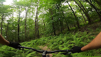
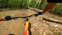
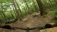
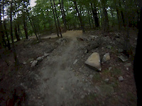
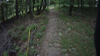
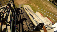
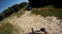
Photos of McHenry Mountain Bike
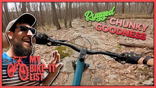
Videos of McHenry Mountain Bike
trail: Thayer Trace Trail
5:15 |
149 |
Aug 8, 2023
trail: Beckman's Trail
2:02 |
51 |
Jul 25, 2023
trail: Indian Turnip Trail
3:35 |
102 |
Jul 19, 2023
trail: Smooth Operator
5:08 |
668 |
Aug 27, 2012
trail: Easy Does It
3:31 |
191 |
Aug 13, 2011
trail: High Roller
2:46 |
358 |
Jul 31, 2011
trail: Easy Does It
3:21 |
171 |
Jul 31, 2011
9:34 |
187 |
May 12, 2023
Recent Trail Reports
| status | trail | date | condition | info | user |
|---|---|---|---|---|---|
| Cherry Creek Access | Jun 14, 2026 @ 12:56pm (America/New_York) Jun 14, 2026 | Dry | bigbearWV BBLTC | ||
| Thayer Trace Trail | Jun 14, 2026 @ 12:56pm (America/New_York) Jun 14, 2026 | Variable | bigbearWV BBLTC | ||
| Smooth Operator | Sep 10, 2025 @ 8:22am Sep 10, 2025 | Unknown | mpingle2 | ||
| Lookout Trail | Nov 11, 2024 @ 1:12pm Nov 11, 2024 | Ideal | PaddyOOHH | ||
| Cherry Creek Phase 2 | Oct 31, 2024 @ 2:48pm Oct 31, 2024 | Dry | bigbearWV BBLTC | ||
| Indian Turnip Trail | Oct 31, 2024 @ 2:48pm Oct 31, 2024 | Dry | bigbearWV BBLTC | ||
| Beckman's Trail | Oct 24, 2024 @ 3:21pm Oct 24, 2024 | Dry | bigbearWV BBLTC | ||
| Crosscut Trail | Oct 12, 2024 @ 12:23pm Oct 12, 2024 | Ideal | leviathan1976 | ||
| Cherry Creek Loop | Oct 12, 2024 @ 12:23pm Oct 12, 2024 | Ideal | leviathan1976 | ||
| IMBA Trainer | Sep 22, 2024 @ 10:13am Sep 22, 2024 | Ideal | kbfrank MORE-GUMBO |
Activity Feed
| username | action | type | title | date |
|---|---|---|---|---|
| bigbearWV | add | report | activity #97002017 and 1 more | Jun 14, 2026 @ 1:46pm Jun 14, 2026 |
| Danish8999 | ridden | trail | activity #96151697 | Jun 3, 2026 @ 6:47am Jun 3, 2026 |
| jaharv | wishlist | trail | activity #95788169 | May 29, 2026 @ 10:37am May 29, 2026 |
| Joseph8PkDl | wishlist | region | activity #92992023 | Apr 19, 2026 @ 4:56pm Apr 19, 2026 |
| kconnolly44 | wishlist | route | activity #92148534 | Apr 7, 2026 @ 4:21pm Apr 7, 2026 |
Recent Comments
| username | type | title | comment | date |
|---|---|---|---|---|
| trail | This trail is NOT a trail. Stay away. | Sep 10, 2025 @ 8:21am Sep 10, 2025 | ||
| trail | From what I read on the sign at the trailhead,... | Dec 12, 2024 @ 6:09pm Dec 12, 2024 | ||
| trail | Tree down on beckman | Nov 6, 2023 @ 10:49am Nov 6, 2023 | ||
| report | Treee down on Beckmann | Nov 6, 2023 @ 10:48am Nov 6, 2023 | ||
| trail | Why would you want to ride this up? There are... | Sep 2, 2023 @ 1:31pm Sep 2, 2023 |
Local Badges
-

Epic Ride Climb 2k36 awarded -

Climbing 10k Badge16 awarded -

Climbing 100k Badge0 awarded -

Epic Ride Descent 2k38 awarded -

Descent 10k Badge16 awarded -

Descent 100k Badge0 awarded
Bike & Skill Parks
| name | type | city | rating |
|---|---|---|---|
| Wisp Resort | bike park | McHenry |
Activity Type Stats
| activitytype | trails | distance | descent | descent distance | total vertical | rating | global rank | state rank | photos | reports | routes | ridelogs |
|---|---|---|---|---|---|---|---|---|---|---|---|---|
| Mountain Bike | 33 | 43 miles | 7,211 ft | 22 miles | 761 ft | #3,860 | #1,296 | 75 | 252 | 3 | 4,533 | |
| E-Bike | 27 | 43 miles | 7,211 ft | 22 miles | 761 ft | #3,406 | #1,203 | 4 | 236 | 176 | ||
| Hike | 30 | 41 miles | 5,876 ft | 20 miles | 748 ft | #5,748 | #2,021 | 1 | 248 | 779 | ||
| Trail Running | 31 | 41 miles | 5,876 ft | 20 miles | 748 ft | #5,357 | #1,687 | 248 | 166 | |||
| Snowmobile | 4 | #489 | #275 | |||||||||
| Snowshoe | 4 | 1,811 ft | 33 ft | 594 ft | 39 ft | #746 | #331 | 2 | ||||
| Downhill Ski | 35 | #470 | #190 | 669 | ||||||||
| Backcountry Ski | 4 | 1,811 ft | 33 ft | 594 ft | 39 ft | #465 | #115 | 59 | ||||
| Nordic Ski | 1 | 1,811 ft | 33 ft | 594 ft | 39 ft | 40 |
Frequently Asked Questions About McHenry
▼
What are the best places to ride in McHenry?
McHenry has 5 areas to explore for mountain biking. The top rated areas are:
▼
What are the highest rated mountain biking trails in McHenry?
The highest rated mountain biking trails in McHenry are:
- Thayer Trace Trail (4.4/5)
- Cherry Creek Loop (4.3/5)
- Cherry Creek Phase 2 (4.3/5)
- Indian Turnip Trail (4.2/5)
- Silver Trail (4.1/5)
▼
What is the best time of the year to ride in McHenry?
Based on ride log data, the most popular months to ride in McHenry are:
- July (108 activities)
- June (68 activities)
- September (64 activities)
▼
Where can I park to ride in McHenry?
There are 9 parking locations listed in McHenry. The most popular parking spots are: View all parking and trailhead locations on the map to plan your visit.
Activities
Trails
- By brenthillier
 NSMBA TRAILFORKS & contributors
 - Admins: apply
- #14841 - 2,514 views
- mchenry activity log | embed map of McHenry mountain bike trails | mchenry mountain biking points of interest
Downloading of trail gps tracks in kml & gpx formats is enabled for McHenry.
You must login to download files.