close
-
Layers w
- Weather Layers
- Pro
- Pro
- Pro
- Pro
- Pro
- Pro
- More Layers
- Pro
- Pro
- Pro
- Pro
-
Upgrade to

3D
Trail Conditions
- Unknown
- Snow Groomed
- Snow Packed
- Snow Covered
- Snow Cover Partial
- Freeze/thaw Cycle
- Icy
- Prevalent Mud
- Wet
- Variable
- Ideal
- Dry
- Very Dry
Trail Flow (Ridden Direction)
Trailforks scans users ridelogs to determine the most popular direction each trail is ridden. A good flowing trail network will have most trails flowing in a single direction according to their intension.
The colour categories are based on what percentage of riders are riding a trail in its intended direction.
The colour categories are based on what percentage of riders are riding a trail in its intended direction.
- > 96%
- > 90%
- > 80%
- > 70%
- > 50%
- < 50%
- bi-directional trail
- no data
Trail Last Ridden
Trailforks scans ridelogs to determine the last time a trail was ridden.
- < 2 days
- < 1 week
- < 2 weeks
- < 1 month
- < 6 months
- > 6 months
Trail Ridden Direction
The intended direction a trail should be ridden.
- Downhill Only
- Downhill Primary
- Both Directions
- Uphill Primary
- Uphill Only
- One Direction
Contribute Details
Colors indicate trail is missing specified detail.
- Description
- Photos
- Description & Photos
- Videos
Trail Popularity ?
Trailforks scans ridelogs to determine which trails are ridden the most in the last 9 months.
Trails are compared with nearby trails in the same city region with a possible 25 colour shades.
Think of this as a heatmap, more rides = more kinetic energy = warmer colors.
- most popular
- popular
- less popular
- not popular
ATV/ORV/OHV Filter
Max Vehicle Width
inches
US Cell Coverage
Legend

Radar Time
Activity Recordings
Trailforks uses anonymized public activity data.
?
Activity Recordings
Trailforks uses anonymized public activity data.
?
Personal Heatmap
▶
Activity Types
all
/
none
▶
Options
2
Date range
month
–
Winter Trails
Warning
A routing network for winter maps does not exist. Selecting trails using the winter trails layer has been disabled.
Missing Trails
Most Popular
Least Popular
Trails are colored based on popularity. The more popular a trail is, the more red. Less popular trails trend towards green.
Jump Magnitude Heatmap
Heatmap of where riders jump on trails. Zoom in to see individual jumps, click circles to view jump details.
BC Backroad Status
![map legend]()
Service Road Atlas is a free to use, community-driven service for viewing and creating reports on the numerous back-country service roads around B.C. and Alberta.

Slope Aspect
Direction the slope faces
Trails Deemphasized
Trails are shown in grey.
Only show trails with no bike usage.
Suggested Layers
Based on selected activity type
Save the current map location and zoom level as your default home location whenever this page is loaded.
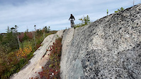
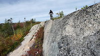
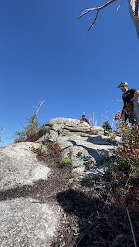
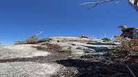
SaveA system of trails spanning granite rock faces, pine and lichen barrens, and lush Acadian forest in the McIntosh Run watershed.
Much of the area burned in a forest fire in 2008, providing a unique, stark trail experience characterized by grippy granite bedrock, views that reach the ocean, and challenging ledges and drops.
If you are driving to the trails, the recommended starting locations with parking are
- Hartlen Park;
- Lions Rink (2 blocks from Clark Kent trail); and
- Long Pond parking near In-N-Out trail.
At other trailheads the parking is on-street and minimal, and streets in the residential neighbourhoods are too narrow for 2-way traffic. To maintain a positive relationship with the local residents, please consider parking at the aforementioned locations. At trailheads please keep down the noise, keep dogs on leash, and don't change in public.
As of 2023, the sanctioned network consists of about 26km of trails. 20km of this has been built since 2016 under land-use agreements by MRWA. 2km are adopted historical and fishing footpaths, and about 4km are adopted older trails from what some MTBers called the 'fight trail system', with all structures replaced and most drainage issues addressed. Roughly 5km of unauthorized trails on private land still connect to the sanctioned system, including Flat Lake-loop and Gords. Caution signs are posted on trails that cross into private land, and these trails are not maintained or promoted by MRWA.
For more information about the trails, and to contribute the maintaining and growing the network, please see Singletrack Information.
Primary Trail Type: Cross-Country
eBikes Allowed:
No
AKA: Fight Trail
Land Status: Conservation Reserve
 google parking directions
Links
- http://mcintoshrun.ca/
- https://www.facebook.com/McIntoshRunWatershedAssociation/
- https://www.instagram.com/mcintoshrun/
Region Supporters & Maintainers
![]()
Cyclesmith
since 2019Sponsor- Nova Scotia
since 2019Sponsor ![]()
Ducks Unlimited (Atlantic)
since 2019Sponsor- Patagonia Halifax
since 2021Sponsor ![]()
Giant Bicycle Halifax
since 2020Sponsor- Custom Clean Atlantic
trail builderSponsor ![]()
MEC Halifax
2017 - 2020Sponsor![]()
Mountain Bike Halifax
2018 - 2020Sponsor![]()
Bicycle Nova Scotia
2016 - 2017Sponsor
Activities Click to view
- Mountain Bike
40 trails
- Hike
42 trails
- Trail Running
42 trails
- Snowshoe
34 trails
Region Details
- 2
- 7
- 18
- 9
- 2
Region Status
Open as of May 20, 2026Stats
- Avg Trail Rating
- Global Ranking
- #484
- State Ranking
- #3
- Trails (view details)
- 40
- Trails Mountain Bike
- 40
- Trails Hike
- 42
- Trails Trail Running
- 42
- Trails Snowshoe
- 34
- Total Distance
- 21 miles
- Total Descent
- 1,705 ft
- Total Vertical
- 195 ft
- Highest Trailhead
- 223 ft
- Reports
- 1,922
- Photos
- 777
- Ridden Counter
- 16,958
Popular McIntosh Run Mountain Biking Trails
• 100 ★ 3.8 • 646 ft • 2 ft • 644 •
Short entrance trail to the McIntosh Run system. It leads from the trailhead at the Alabaster Way cul-de-sac, to .
• 100 ★ 4.6 • 2,838 ft • 16 ft • 602 •
is a mix of dirt, granite bedrock and built rock work that is mostly downhill from the Alabaster Way cul-de-sac trailhead. This is a two-way, busy trail with lots of hikers and bikers. Look out for climbers and hikers if descending and...
• 100 ★ 4.8 • 3,396 ft • 27 ft • 592 •
is an entrance trail to the system that starts/finishes at a narrow grass park parcel on Alabaster Way, between #146 and #138. The trail approximately follows the between the Colpitt Lake and McIntosh Run watersheds, and affords great...
• 95 ★ 4.6 • 1 mile • 138 ft • 563 •
Popular blue difficulty singletrack. This multi-use trail can be used both directions and has a moderate overall physical rating with a 138 ft blue climb. It features drop, ladder bridge and rock face. On average it takes 15 minutes to complete this trail.
• 100 ★ 4.6 • 3,071 ft • 58 ft • 525 •
is a mild mannered super hero that starts at Hartlen Park ballfield (on Lois Lane) and extends to Trail. Clark Kent is smooth, has banked turns in places, and has no big climbs. Use it as an entrance to the trail system, or just as a...
• 95 ★ 4.9 • 2 miles • 115 ft • 508 •
Highly rated popular blue difficulty singletrack. This multi-use trail can be used both directions and has a moderate overall physical rating with a 115 ft blue climb. It features berm, bridge, drop, jump, gap jump, ladder bridge and rock face. Trail visibility is always easy to follow. On average it takes 19 minutes to complete this trail.
• 95 ★ 4.5 • 1,535 ft • 11 ft • 488 •
ecmtb.net presents The , a fun little trail using exposed granite segments linked together to create a flat loop. With no real elevation change but lots of undulations, allows you to push the pace if you want -- in either direction....
• 95 ★ 4.5 • 220 ft • 0 ft • 428 •
is an alternate line to the top of trail. In the downhill direction, M&C starts with a short smooth granite descent (the milk) followed by a few roots, then a 30cm wide elevated skinny (the cookies). The cookies are only about 30cm...
McIntosh Run Mountain Bike Routes
Blue Granite Tour Featured
★ 4.0 • 5 miles • 331 ft • 8 • Loop •
This lollipop route tours the most popular front-country granite trails, with a warm-up/cool down on the...
Granite Fondo 2021 - full monte Featured
★ 4.0 • 21 miles • 1,269 ft • 24 •
Full route for 2021 Granite Fondo * --> --> * Lower Attic --> --> downhill --> straight on...
Granite Fondo Middle Distance 2021 Featured
14 miles • 810 ft • 10 •
Middle distance blue trail route for 2021 Granite Fondo.
Blue/Black Granite Tour Featured
11 miles • 712 ft • 13 • Loop •
This lollipop route tours the front-country granite trails, with a warm-up/cool down on the green trail....
Granite Fondo 2021 - 10km route Featured
6 miles • 388 ft • 9 •
2021 Granite Fondo at McIntosh Run trails. 10km route. There are separate routes for ~22 and ~34km distances)
★ 5.0 • 6 miles • 406 ft • 5 • Point to Point •
One of the longer point to point routes at the Mac. Brings in most of what the Mac has to offer for Medium...
Photos of McIntosh Run Mountain Bike
Videos of McIntosh Run Mountain Bike

trail: Duck 'n Run
0:05 |
147 |
May 3, 2024
trail: Lou's Basement
0:09 |
125 |
May 3, 2024
trail: Lou's Basement
0:09 |
|
May 3, 2024
trail: Gord's Gold
0:07 |
285 |
May 3, 2024
trail: Gord's Gold
0:07 |
|
May 3, 2024

trail: Osprey
4:15 |
69 |
Nov 11, 2021
trail: Clark Kent
0:09 |
80 |
Mar 5, 2021
trail: Clark Kent
0:52 |
323 |
Nov 10, 2020
Recent Trail Reports
| status | trail | date | condition | info | user |
|---|---|---|---|---|---|
| Chimney | May 20, 2026 @ 11:44am (America/Halifax) May 20, 2026 | Variable | PcDodge MRWA | ||
| Milk and Cookies | May 17, 2026 @ 4:15pm (America/Halifax) May 17, 2026 | Ideal | nsducati | ||
| Osprey | May 17, 2026 @ 4:15pm (America/Halifax) May 17, 2026 | Ideal | nsducati | ||
| I/O | May 17, 2026 @ 4:15pm (America/Halifax) May 17, 2026 | Ideal | nsducati | ||
| The Attic | May 17, 2026 @ 4:15pm (America/Halifax) May 17, 2026 | Ideal | nsducati | ||
| Divide | May 17, 2026 @ 4:15pm (America/Halifax) May 17, 2026 | Ideal | nsducati | ||
| Clark Kent | May 17, 2026 @ 4:15pm (America/Halifax) May 17, 2026 | Ideal | nsducati | ||
| Orange Jelly | Mar 19, 2026 @ 3:26pm (America/Halifax) Mar 19, 2026 | Variable | PcDodge MRWA | ||
| Boulderama | Mar 6, 2026 @ 2:15pm (America/Halifax) Mar 6, 2026 | Unknown | PcDodge MRWA | ||
| McIntosh Run Community Trail | Jan 13, 2026 @ 8:55am (America/Halifax) Jan 13, 2026 | Icy | Chrislee97 |
Activity Feed
| username | action | type | title | date |
|---|---|---|---|---|
| foysr | wishlist | region | activity #97029498 | Jun 15, 2026 @ 2:45am Jun 15, 2026 |
| dinahmite | wishlist | route | activity #96577325 | Jun 8, 2026 @ 6:11pm Jun 8, 2026 |
| Schuey65 | wishlist | route | activity #96192188 | Jun 3, 2026 @ 5:15pm Jun 3, 2026 |
| ElliotP7 | add | photo | activity #95210275 | May 21, 2026 @ 5:07pm May 21, 2026 |
| lplug | like | report | activity #95190426 | May 21, 2026 @ 11:34am May 21, 2026 |
Recent Comments
| username | type | title | comment | date |
|---|---|---|---|---|
| trail | Great flow trail!! | Sep 14, 2025 @ 5:18pm Sep 14, 2025 | ||
| trail | Thank you - those guys have been extremely... | Mar 15, 2025 @ 4:50pm Mar 15, 2025 | ||
| trail | ... | Mar 14, 2025 @ 2:11pm Mar 14, 2025 | ||
| trail | Anyone know a good shop to rent a capable bike... | Mar 14, 2025 @ 11:12am Mar 14, 2025 | ||
| report | Notification will also be posted on socials... | Jul 24, 2024 @ 9:39am Jul 24, 2024 |
Nearby Areas
| name | distance | ||||
|---|---|---|---|---|---|
| Point Pleasant Park | 1.9 km | ||||
| Sir Sandford Fleming Park | 4 | 2.4 km | |||
| Long Lake Provincial Park | 1 | 26 | 2 | 3.6 km | |
| Hail Pond Community Park | 3.7 km | ||||
| Deer Trails | 1 | 6 | 4.8 km |
Local Badges
-

Completionist18 awardedearned
Local Products
Local Trail Supporters
![]()
![]()
![Oxford @8]()
- Sportwheels Sports Excellence
- Nacora Insurance Brokers
Activity Type Stats
| activitytype | trails | distance | descent | descent distance | total vertical | rating | global rank | state rank | photos | reports | routes | ridelogs |
|---|---|---|---|---|---|---|---|---|---|---|---|---|
| Mountain Bike | 40 | 21 miles | 1,693 ft | 8 miles | 194 ft | #484 | #3 | 768 | 1,918 | 14 | 20,808 | |
| Hike | 42 | 21 miles | 1,706 ft | 8 miles | 194 ft | #5,400 | #16 | 5 | 1,911 | 7 | 665 | |
| Trail Running | 42 | 21 miles | 1,706 ft | 8 miles | 194 ft | #4,326 | #10 | 1,911 | 6 | 834 | ||
| Snowshoe | 34 | 16 miles | 1,230 ft | 6 miles | 184 ft | #355 | #8 | 4 | 915 | 3 | 42 |
Frequently Asked Questions About McIntosh Run
▼
What are the highest rated mountain biking trails in McIntosh Run?
The highest rated mountain biking trails in McIntosh Run are:
- Fire Escape (4.5/5)
- Divide (4.4/5)
- Osprey (4.4/5)
- Duck 'n Run (4.4/5)
- The Attic (4.4/5)
▼
What is the best time of the year to ride in McIntosh Run?
Based on ride log data, the most popular months to ride in McIntosh Run are:
- July (447 activities)
- June (422 activities)
- May (418 activities)
▼
Where can I park to ride in McIntosh Run?
There are 7 parking locations listed in McIntosh Run. The most popular parking spots are:
- Limited on-street parking on Norawarren Drive
- Esso Road Parking
- Hartlen Field Parking
- Parking at Roach's Pond
- Long Pond parking, near Norawarren Trailhead
▼
What is the longest trail in McIntosh Run?
The longest trail in McIntosh Run is McIntosh Run Community Trail at 2.7 km. View all trails sorted by distance.
Activities
Trails
- By canadaka
 Trailforks & contributors
 - Admins: MRWA
- #4710 - 50,361 views
- mcintosh run activity log | embed map of McIntosh Run mountain bike trails | mcintosh run mountain biking points of interest polygons
Downloading of trail gps tracks in kml & gpx formats is enabled for McIntosh Run.
You must login to download files.