close
-
Layers w
- Weather Layers
- Pro
- Pro
- Pro
- Pro
- Pro
- Pro
- More Layers
- Pro
- Pro
- Pro
- Pro
-
Upgrade to

3D
Trail Conditions
- Unknown
- Snow Groomed
- Snow Packed
- Snow Covered
- Snow Cover Partial
- Freeze/thaw Cycle
- Icy
- Prevalent Mud
- Wet
- Variable
- Ideal
- Dry
- Very Dry
Trail Flow (Ridden Direction)
Trailforks scans users ridelogs to determine the most popular direction each trail is ridden. A good flowing trail network will have most trails flowing in a single direction according to their intension.
The colour categories are based on what percentage of riders are riding a trail in its intended direction.
The colour categories are based on what percentage of riders are riding a trail in its intended direction.
- > 96%
- > 90%
- > 80%
- > 70%
- > 50%
- < 50%
- bi-directional trail
- no data
Trail Last Ridden
Trailforks scans ridelogs to determine the last time a trail was ridden.
- < 2 days
- < 1 week
- < 2 weeks
- < 1 month
- < 6 months
- > 6 months
Trail Ridden Direction
The intended direction a trail should be ridden.
- Downhill Only
- Downhill Primary
- Both Directions
- Uphill Primary
- Uphill Only
- One Direction
Contribute Details
Colors indicate trail is missing specified detail.
- Description
- Photos
- Description & Photos
- Videos
Trail Popularity ?
Trailforks scans ridelogs to determine which trails are ridden the most in the last 9 months.
Trails are compared with nearby trails in the same city region with a possible 25 colour shades.
Think of this as a heatmap, more rides = more kinetic energy = warmer colors.
- most popular
- popular
- less popular
- not popular
ATV/ORV/OHV Filter
Max Vehicle Width
inches
US Cell Coverage
Legend

Radar Time
Activity Recordings
Trailforks uses anonymized public activity data.
?
Activity Recordings
Trailforks uses anonymized public activity data.
?
Personal Heatmap
▶
Activity Types
all
/
none
▶
Options
2
Date range
month
–
Winter Trails
Warning
A routing network for winter maps does not exist. Selecting trails using the winter trails layer has been disabled.
Missing Trails
Most Popular
Least Popular
Trails are colored based on popularity. The more popular a trail is, the more red. Less popular trails trend towards green.
Jump Magnitude Heatmap
Heatmap of where riders jump on trails. Zoom in to see individual jumps, click circles to view jump details.
BC Backroad Status
![map legend]()
Service Road Atlas is a free to use, community-driven service for viewing and creating reports on the numerous back-country service roads around B.C. and Alberta.

Slope Aspect
Direction the slope faces
Trails Deemphasized
Trails are shown in grey.
Only show trails with no bike usage.
Suggested Layers
Based on selected activity type
Save the current map location and zoom level as your default home location whenever this page is loaded.
SaveA BearTown is place on mountain called Sljeme. And there are for now 3 downhill trails. We have something for everyone
Primary Trail Type: All-Mountain & Downhill
Shuttleable: YES
Land Status: National Park
 google parking directions
 Access Info:
gornji lukšiči
This region uses the Uk/Euro style trail grading system.
Activities Click to view
- Mountain Bike
34 trails
- E-Bike
12 trails
- Hike
23 trails
- Trail Running
23 trails
Region Details
- 5
- 7
- 9
- 7
- 3
Region Status
Caution as of Jun 11, 2026Stats
- Avg Trail Rating
- Trails (view details)
- 34
- Trails Mountain Bike
- 34
- Trails E-Bike
- 12
- Trails Hike
- 23
- Trails Trail Running
- 23
- Total Distance
- 44 miles
- Total Descent
- 20,041 ft
- Total Vertical
- 2,844 ft
- Highest Trailhead
- 3,369 ft
- Reports
- 1,358
- Photos
- 110
- Ridden Counter
- 3,179
Popular Medvedgrad Mountain Biking Trails
• 90 ★ 4.8 • 4 miles • 116 ft • 269 •
Enduro trail built by local bike club " BK ". The trail has two small uphills. Enjoy!
• 85 ★ 4.9 • 2,707 ft • 0 ft • 120 •
New line on trail no. 15. Connects trail no. 15 with trail. If you ride 57 (new line) - 15 (new line) and then , you will be 95% on singletrack instead of gravel road (because the old 57 is mostly gravel). And this is a new trail so you...
• 70 ★ 4.5 • 2,801 ft • 0 ft • 120 •
Connects trail number 52 with "Opusteno" trail
• 45 ★ 5.0 • 4,490 ft • 135 ft • 80 •
Trail called HPD (in translation "Croatian hikiers association" trail) or number 52 on some maps. Very narrow singletrack with some technical parts, rocks and roots. Watch out for hikers because this is their trail. Can be used as...
• 70 ★ 3.7 • 2 miles • 45 ft • 77 •
Hiking trail popular among mountainbikers. Higher frequency of hikers during weekends.
• 100 ★ 5.0 • 2,300 ft • 3 ft • 71 •
Popular red difficulty singletrack. This mountain bike primary trail can be used downhill primary.
• 100 ★ 5.0 • 1,503 ft • 0 ft • 69 •
Good alternative to get to the start of Enduro trail from the gondola. Twisty singletrack with off-camber and many small uphills
Medvedgrad Mountain Bike Routes
★ 4.0 • 10 miles • 2,605 ft • 3 • Out & Back •
Cool little loop in which climb ends on Mountain home Risnjak where there is always something nice to eat...
★ 5.0 • 8 miles • 2,355 ft • 0 • Point to Point •
Ascent is done over hikers favourite trail Lojstek (so slow down even if you are going uphill). Few...
6 miles • 2,277 ft • 0 • Point to Point •
My personal favorite. Uphill is on hikers trail Lojstek so be nice to hikers. When almost on top, at the...
6 miles • 2,277 ft • 0 • Point to Point •
Long and slow climb over Lojstek trail (this one is a hikers favourite, so slow down if you are going fast...
• 5 miles • 2,648 ft • 2 •
• 4 miles • 799 ft • 1 •
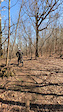
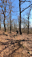
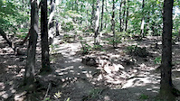
Photos of Medvedgrad Mountain Bike
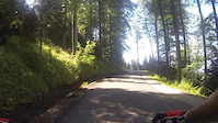
Videos of Medvedgrad Mountain Bike
trail: Stribor
3:11 |
8 |
Feb 27, 2026
trail: Regoč
2:10 |
12 |
Feb 26, 2026

3:10 |
153 |
Nov 15, 2020
trail: Opušteno
0:08 |
486 |
Sep 9, 2020
trail: Muco
3:11 |
5 |
Jul 5, 2018
trail: Grma TROJKA
0:19 |
738 |
Dec 27, 2012
trail: Utopia
5:35 |
32 |
Jan 6, 2026 , Zagreb

trail: Rodeo drive
49:58 |
21 |
Jan 6, 2026 , Zagreb
Current Trail Warnings
| status | trail | date | condition | user | info |
|---|---|---|---|---|---|
| Grma TROJKA | Jun 11, 2026 @ 9:46am (Europe/Zagreb) Jun 11, 2026 | Variable | Jahavwk | ||
| Pilana downhill | May 30, 2026 @ 5:58pm (Europe/Zagreb) May 30, 2026 | Very Dry | adkarzen | Multiple large trees down across trail,... | |
| Leustekova staza | May 24, 2026 @ 11:46pm (Europe/Zagreb) May 24, 2026 | Ideal | adkarzen | Unpassable due to multiple downed trees... |
Recent Trail Reports
| status | trail | date | condition | info | user |
|---|---|---|---|---|---|
| 57 ( new line - Osinjak ) | May 25, 2026 @ 12:47pm (Europe/Zagreb) May 25, 2026 | Dry | adkarzen | ||
| Muhara | May 25, 2026 @ 12:47pm (Europe/Zagreb) May 25, 2026 | Dry | adkarzen | ||
| MSU | Mar 25, 2026 @ 2:13pm (Europe/Zagreb) Mar 25, 2026 | Ideal | adkarzen | ||
| Leustek - Runolist | Feb 28, 2026 @ 7:25am (Europe/Zagreb) Feb 27, 2026 | Variable | MajaZmaja | ||
| Kustošijanski makadam do Risnjaka | Feb 28, 2026 @ 7:25am (Europe/Zagreb) Feb 27, 2026 | Variable | MajaZmaja | ||
| HPD 52 | Feb 14, 2026 @ 9:18am (Europe/Zagreb) Feb 14, 2026 | Prevalent Mud | ijergovi | ||
| Sljeme vidikovac | Feb 14, 2026 @ 9:18am (Europe/Zagreb) Feb 14, 2026 | Ideal | ijergovi | ||
| Sopotski makadam - Gornje Vrapče | Jan 4, 2026 @ 5:32pm (Europe/Zagreb) Jan 4, 2026 | Wet | BikeTravelVlog | ||
| Regoč | Dec 3, 2025 @ 5:52pm (Europe/Zagreb) Dec 3, 2025 | Ideal | Gogs79 | ||
| Opušteno | Nov 15, 2025 @ 12:25pm (Europe/Zagreb) Nov 15, 2025 | Ideal | Skappy86 |
Activity Feed
| username | action | type | title | date |
|---|---|---|---|---|
| Darko5mvfdA | wishlist | trail | activity #97099156 | Jun 16, 2026 @ 4:21am 3 days |
| Darko5mvfdA | wishlist | trail | activity #97055560 | Jun 15, 2026 @ 11:33am Jun 15, 2026 |
| Jahavwk | add | report | activity #96722542 | Jun 11, 2026 @ 12:46am Jun 11, 2026 |
| Michael1OaWUI | difficultyvote | trail | activity #96671392 | Jun 10, 2026 @ 7:26am Jun 10, 2026 |
| MarkoJObCMt | add | report | activity #96227994 | Jun 4, 2026 @ 7:59am Jun 4, 2026 |
Recent Comments
| username | type | title | comment | date |
|---|---|---|---|---|
| trail | Unrideable after the strorm, a lot of fallen... | May 11, 2026 @ 11:42am May 11, 2026 | ||
| trail | Dosta zahtjevna staza, puno korijenja, rock... | Oct 16, 2025 @ 5:02am Oct 16, 2025 | ||
| trail | Really great trail. Plenty of different lines... | Sep 29, 2025 @ 1:06pm Sep 29, 2025 | ||
| trail | Da sam bar ranije tvoj komentar pročitao. | Jun 5, 2025 @ 12:42am Jun 5, 2025 | ||
| trail | staza treba ljubavi…kanali od vode po stazi,... | Aug 24, 2024 @ 3:00am Aug 24, 2024 |
Nearby Areas
| name | distance | ||||
|---|---|---|---|---|---|
| Savski nasip | 2.3 km | ||||
| Markuševac | 7 | 3 km | |||
| Dotka | 3.7 km | ||||
| Zelena Magistrala | 2 | 4.3 km | |||
| Maksimir | 2 | 4.5 km |
Local Badges
-

Completionist1 awarded
Activity Type Stats
| activitytype | trails | distance | descent | descent distance | total vertical | rating | global rank | state rank | photos | reports | routes | ridelogs |
|---|---|---|---|---|---|---|---|---|---|---|---|---|
| Mountain Bike | 34 | 41 miles | 18,255 ft | 25 miles | 2,844 ft | #865 | #2 | 108 | 1,357 | 4 | 7,353 | |
| E-Bike | 12 | 7 miles | 3,035 ft | 4 miles | 2,562 ft | #1,098 | #14 | 2 | 1,228 | 3 | 1,878 | |
| Hike | 23 | 36 miles | 14,173 ft | 21 miles | 2,844 ft | #1,166 | #8 | 1,289 | 1,283 | |||
| Trail Running | 23 | 36 miles | 14,173 ft | 21 miles | 2,844 ft | #672 | #7 | 1,289 | 217 |
Frequently Asked Questions About Medvedgrad
▼
What are the highest rated mountain biking trails in Medvedgrad?
The highest rated mountain biking trails in Medvedgrad are:
- Opušteno (4.6/5)
- Rodeo drive (4.5/5)
- 15 (new line) (4.5/5)
- Grma TROJKA (4.4/5)
- Muhara (4.3/5)
▼
What is the best time of the year to ride in Medvedgrad?
Based on ride log data, the most popular months to ride in Medvedgrad are:
- July (47 activities)
- October (42 activities)
- August (37 activities)
▼
Where can I park to ride in Medvedgrad?
There are 2 parking locations listed in Medvedgrad. The most popular parking spots are:
▼
What is the longest trail in Medvedgrad?
The longest trail in Medvedgrad is 8ica at 5.0 miles. View all trails sorted by distance.
Activities
- By nidjozg & contributors
- Admins: BKO
- #5596 - 13,043 views
- medvedgrad activity log | embed map of Medvedgrad mountain bike trails | medvedgrad mountain biking points of interest
Downloading of trail gps tracks in kml & gpx formats is enabled for Medvedgrad.
You must login to download files.