close
-
Layers w
- Weather Layers
- Pro
- Pro
- Pro
- Pro
- Pro
- Pro
- More Layers
- Pro
- Pro
- Pro
- Pro
-
Upgrade to

3D
Trail Conditions
- Unknown
- Snow Groomed
- Snow Packed
- Snow Covered
- Snow Cover Partial
- Freeze/thaw Cycle
- Icy
- Prevalent Mud
- Wet
- Variable
- Ideal
- Dry
- Very Dry
Trail Flow (Ridden Direction)
Trailforks scans users ridelogs to determine the most popular direction each trail is ridden. A good flowing trail network will have most trails flowing in a single direction according to their intension.
The colour categories are based on what percentage of riders are riding a trail in its intended direction.
The colour categories are based on what percentage of riders are riding a trail in its intended direction.
- > 96%
- > 90%
- > 80%
- > 70%
- > 50%
- < 50%
- bi-directional trail
- no data
Trail Last Ridden
Trailforks scans ridelogs to determine the last time a trail was ridden.
- < 2 days
- < 1 week
- < 2 weeks
- < 1 month
- < 6 months
- > 6 months
Trail Ridden Direction
The intended direction a trail should be ridden.
- Downhill Only
- Downhill Primary
- Both Directions
- Uphill Primary
- Uphill Only
- One Direction
Contribute Details
Colors indicate trail is missing specified detail.
- Description
- Photos
- Description & Photos
- Videos
Trail Popularity ?
Trailforks scans ridelogs to determine which trails are ridden the most in the last 9 months.
Trails are compared with nearby trails in the same city region with a possible 25 colour shades.
Think of this as a heatmap, more rides = more kinetic energy = warmer colors.
- most popular
- popular
- less popular
- not popular
ATV/ORV/OHV Filter
Max Vehicle Width
inches
US Cell Coverage
Legend

Radar Time
Activity Recordings
Trailforks uses anonymized public activity data.
?
Activity Recordings
Trailforks uses anonymized public activity data.
?
Personal Heatmap
▶
Activity Types
all
/
none
▶
Options
2
Date range
month
–
Winter Trails
Warning
A routing network for winter maps does not exist. Selecting trails using the winter trails layer has been disabled.
Missing Trails
Most Popular
Least Popular
Trails are colored based on popularity. The more popular a trail is, the more red. Less popular trails trend towards green.
Jump Magnitude Heatmap
Heatmap of where riders jump on trails. Zoom in to see individual jumps, click circles to view jump details.
BC Backroad Status
![map legend]()
Service Road Atlas is a free to use, community-driven service for viewing and creating reports on the numerous back-country service roads around B.C. and Alberta.

Slope Aspect
Direction the slope faces
Trails Deemphasized
Trails are shown in grey.
Only show trails with no bike usage.
Suggested Layers
Based on selected activity type
Save the current map location and zoom level as your default home location whenever this page is loaded.
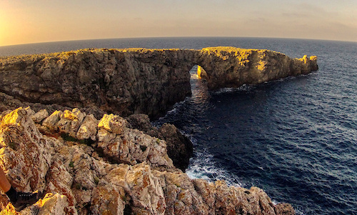
SaveMenorca (Minorca) is one of Spain’s Balearic islands in the Mediterranean Sea. Traditionally more low-key than its neighbors, Mallorca (Majorca) and Ibiza, it’s known for its endless beaches, from miles-long sandy crescents to rocky, turquoise-watered bays called “calas.” Pine trees fringe the coast. The capital, Mahon, is on a bluff overlooking a large harbor, with Georgian mansions and a church with 13th-century roots.
This region uses the Uk/Euro style trail grading system.
Activities Click to view
- Mountain Bike
26 trails
- E-Bike
5 trails
- Horse
18 trails
- Hike
26 trails
- Trail Running
26 trails
Region Details
- 20
- 1
- 5
Stats
- Avg Trail Rating
- Trails (view details)
- 26
- Trails Mountain Bike
- 26
- Trails E-Bike
- 5
- Trails Horse
- 18
- Trails Hike
- 26
- Trails Trail Running
- 26
- Total Distance
- 120 miles
- Total Descent
- 13,713 ft
- Total Vertical
- 643 ft
- Highest Trailhead
- 645 ft
- Reports
- 17
- Photos
- 9
- Ridden Counter
- 1,586
Sub Regions
- Ciudadela (2)
- Cala Galdana (2)
Popular Menorca Mountain Biking Trails
• 50 ★ 4.0 • 7 miles • 957 ft • 89 •
Part of the famous loop around the island. Stage 14 is from Cala Galdana to Sant Tomàs. Local info: Cal un bon nivell físic i bicis en bon estat, a ser possible doble suspensió. El Camí de Cavalls és ciclable en un 95% per a gent...
• ★ 5.0 • 5 miles • 608 ft • 71 •
Part of the famous loop around the island. Stage 16 between Son Bou and Cala en Porter is hard for bikes; especially the part around Cala Llucalari. Expect to carry your bike at times - or consider skipping that part.
• ★ 5.0 • 6 miles • 885 ft • 65 •
Etapa 7. Els Alocs - Algaiarens The Camí de Cavalls is an ancient path of 186 km (116 miles) that encircles the island of Menorca. This long-distance walking / cycling / horse riding route is the GR 223 of the Senderos de Gran...
• ★ 5.0 • 8 miles • 546 ft • 49 •
Etapa 12. Cap d’Artrutx - Cala en Turqueta. Easy. The Camí de Cavalls is an ancient path of 186 km (116 miles) that encircles the island of Menorca. This long-distance walking / cycling / horse riding route is the GR 223 of the...
• ★ 5.0 • 6 miles • 941 ft • 45 •
Etapa 5. Cala Tirant - Playa de Binimel·là The Camí de Cavalls is an ancient path of 186 km (116 miles) that encircles the island of Menorca. This long-distance walking / cycling / horse riding route is the GR 223 of the Senderos de...
• ★ 5.0 • 5 miles • 1,496 ft • 43 •
Etapa 6 - Binimel·là to Els Alocs 8.9 km (5.5 miles) Hiking: 5 h rated Difficult ! The Camí de Cavalls is an ancient path of 186 km (116 miles) that encircles the island of Menorca. This long-distance walking / cycling / horse riding...
Menorca Mountain Bike Routes
★ 3.0 • 115 miles • 9,644 ft • 15 • Loop •
The Camí de Cavalls is an ancient path of 186 km (116 miles) that encircles the island of Menorca, Spain....
39 miles • 2,686 ft • 3 • Point to Point •
Epic Cami de Cavalls Etapa 3 2023
43 miles • 4,916 ft • 1 • Point to Point •
Epic Cami de Cavalls Etapa 1 2023
36 miles • 3,046 ft • 2 • Point to Point •
Epic Cami de Cavalls Etapa 2 2023
Photos of Menorca Mountain Bike
Recent Trail Reports
| status | trail | date | condition | info | user |
|---|---|---|---|---|---|
| Cami de Cavalls - stage 14 Cala Galdana | Jul 12, 2025 @ 7:47am Jul 12, 2025 | Very Dry | pacoUExCZm | ||
| Cami de Cavalls - stage 01 Menorca | Jul 26, 2023 @ 12:38am Jul 26, 2023 | Ideal | ToniMenor | ||
| Cami de Cavalls - stage 02 Menorca | Jul 26, 2023 @ 12:38am Jul 26, 2023 | Ideal | ToniMenor | ||
| Cami de Cavalls - stage 13 Cala Galdana | May 27, 2023 @ 1:32am May 27, 2023 | Dry | Bikingo | ||
| Cami de Cavalls - stage 11 Menorca | Oct 7, 2021 @ 12:08pm Oct 7, 2021 | Dry | CarinaA | ||
| Cami de Cavalls - stage 17 Menorca | Aug 27, 2021 @ 11:17pm Aug 27, 2021 | Very Dry | Agrpictel | ||
| Cami de Sa Barrerassa Menorca | Aug 27, 2021 @ 11:17pm Aug 27, 2021 | Very Dry | Agrpictel | ||
| Barranc Calan Porter Menorca | Aug 27, 2021 @ 11:17pm Aug 27, 2021 | Very Dry | Agrpictel | ||
| Cami de Cavalls - stage 19 Menorca | Aug 21, 2021 @ 12:12am Aug 21, 2021 | Dry | Agrpictel | ||
| Cami de Cavalls - stage 10 Menorca | Oct 3, 2020 @ 12:38am Oct 3, 2020 | Very Dry | kaxarrillos |
National Scenic Trails & Official Routes
-
GR 223 Cami des Cavalls
- Mountain Bike
- Hike
Activity Feed
| username | action | type | title | date |
|---|---|---|---|---|
| mikkie110 | wishlist | trail | activity #94990946 | May 18, 2026 @ 11:46am May 18, 2026 |
| Fredo666 | ridden | trail | activity #89937623 | Mar 4, 2026 @ 12:04am Mar 4, 2026 |
| dmborg5 | wishlist | trail | activity #80557873 and 2 more | Sep 17, 2025 @ 2:46pm Sep 17, 2025 |
| luisuriza | wishlist | trail | activity #79804738 and 1 more | Sep 6, 2025 @ 9:27pm Sep 6, 2025 |
| luisuriza | wishlist | trail | activity #79804618 and 15 more | Sep 6, 2025 @ 9:23pm Sep 6, 2025 |
Activity Type Stats
| activitytype | trails | distance | descent | descent distance | total vertical | rating | global rank | state rank | photos | reports | routes | ridelogs |
|---|---|---|---|---|---|---|---|---|---|---|---|---|
| Mountain Bike | 26 | 120 miles | 13,714 ft | 54 miles | 643 ft | 9 | 17 | 4 | 3,874 | |||
| E-Bike | 5 | 4 miles | 400 ft | 2 miles | 233 ft | 14 | 4 | 504 | ||||
| Horse | 18 | 86 miles | 10,000 ft | 38 miles | 417 ft | 2 | ||||||
| Hike | 26 | 120 miles | 13,714 ft | 54 miles | 643 ft | 17 | 1 | 661 | ||||
| Trail Running | 26 | 120 miles | 13,714 ft | 54 miles | 643 ft | 17 | 1 | 89 |
Frequently Asked Questions About Menorca
▼
What are the best places to ride in Menorca?
Menorca has 1 areas to explore for mountain biking. The top rated areas are:
▼
What are the highest rated mountain biking trails in Menorca?
The highest rated mountain biking trails in Menorca are:
- Cami de Cavalls - stage 16 (4.1/5)
- Cami de Cavalls - stage 06 (4.1/5)
- Cami de Cavalls - stage 12 (4.1/5)
- Cami de Cavalls - stage 07 (4.1/5)
- Cami de Cavalls - stage 05 (4.1/5)
▼
What is the best time of the year to ride in Menorca?
Based on ride log data, the most popular months to ride in Menorca are:
- August (16 activities)
- July (8 activities)
- October (4 activities)
▼
What is the longest trail in Menorca?
The longest trail in Menorca is Cami de Cavalls - stage 12 at 13.7 km. View all trails sorted by distance.
- By brenthillier
 NSMBA TRAILFORKS & contributors
 - Admins: mul0w, elyari, AMG, juanx, Angelreing
- #8870 - 8,238 views
- menorca activity log | embed map of Menorca mountain bike trails |
Downloading of trail gps tracks in kml & gpx formats is enabled for Menorca.
You must login to download files.